Juno, Georgia
Submit your own pictures of this place and show them to the world
- OSM Map
- General Map
- Google Map
- MSN Map

| Males: 7,558 | |
| Females: 7,505 |
| Median resident age: | 34.7 years |
| Georgia median age: | 33.4 years |
Zip code: 30534
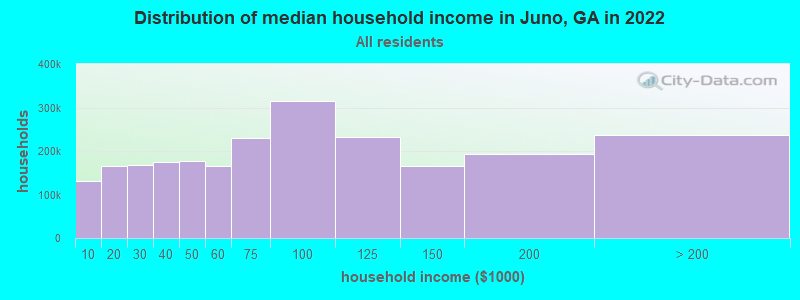
| Juno: | $89,591 |
| GA: | $72,837 |
Estimated per capita income in 2022: $40,030 (it was $21,626 in 2000)
Juno CCD income, earnings, and wages data
Estimated median house or condo value in 2022: $355,147 (it was $125,500 in 2000)
| Juno: | $355,147 |
| GA: | $297,400 |
Mean prices in 2022: all housing units: $431,850; detached houses: $456,221; townhouses or other attached units: $432,165; mobile homes: $79,902
Detailed information about poverty and poor residents in Juno, GA


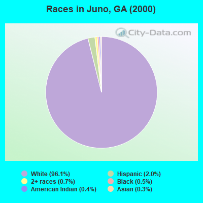
- 10,92396.1%White alone
- 2322.0%Hispanic
- 850.7%Two or more races
- 520.5%Black alone
- 410.4%American Indian alone
- 320.3%Asian alone
- 40.04%Other race alone
Races in Juno detailed stats: ancestries, foreign born residents, place of birth
 Recent articles from our blog. Our writers, many of them Ph.D. graduates or candidates, create easy-to-read articles on a wide variety of topics.
Current Local Time: EST time zone
Elevation: 1513 feet
Land area: 93.4 square miles.
Population density: 161 people per square mile (very low).

| Juno CCD: | 0.7% ($836) |
| Georgia: | 0.9% ($919) |
Nearest city with pop. 50,000+: Johns Creek, GA (24.6 miles  , pop. 76,728).
Nearest city with pop. 200,000+: Atlanta, GA (46.5 miles , pop. 416,474).
Nearest city with pop. 1,000,000+: Chicago, IL (553.2 miles , pop. 2,896,016).
Nearest cities:
), ), ), )Latitude: 34.37 N, Longitude: 84.05 W

| Here: | 2.3% |
| Georgia: | 2.9% |
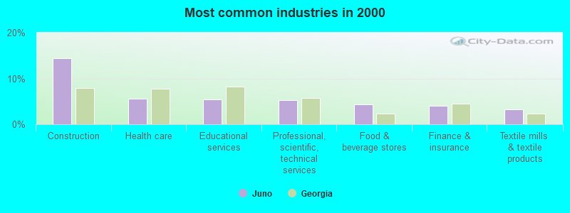
- Construction (14.5%)
- Health care (5.6%)
- Educational services (5.4%)
- Professional, scientific, technical services (5.2%)
- Food & beverage stores (4.4%)
- Finance & insurance (4.0%)
- Textile mills & textile products (3.3%)
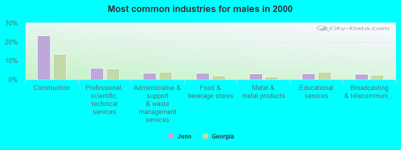
- Construction (23.3%)
- Professional, scientific, technical services (6.0%)
- Administrative & support & waste management services (3.5%)
- Food & beverage stores (3.4%)
- Metal & metal products (3.3%)
- Educational services (3.1%)
- Broadcasting & telecommunications (3.0%)

- Health care (10.6%)
- Educational services (8.4%)
- Social assistance (6.0%)
- Food & beverage stores (5.7%)
- Finance & insurance (5.6%)
- Professional, scientific, technical services (4.2%)
- Real estate & rental & leasing (3.9%)

- Other sales and related occupations, including supervisors (5.7%)
- Other management occupations, except farmers and farm managers (5.4%)
- Other production occupations, including supervisors (3.7%)
- Other office and administrative support workers, including supervisors (3.5%)
- Computer specialists (3.1%)
- Material recording, scheduling, dispatching, and distributing workers (3.0%)
- Driver/sales workers and truck drivers (2.9%)
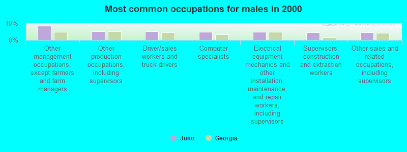
- Other management occupations, except farmers and farm managers (8.6%)
- Other production occupations, including supervisors (5.2%)
- Driver/sales workers and truck drivers (5.1%)
- Computer specialists (4.8%)
- Electrical equipment mechanics and other installation, maintenance, and repair workers, including supervisors (4.7%)
- Supervisors, construction and extraction workers (4.6%)
- Other sales and related occupations, including supervisors (4.6%)
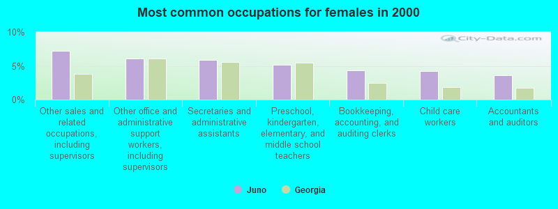
- Other sales and related occupations, including supervisors (7.2%)
- Other office and administrative support workers, including supervisors (6.1%)
- Secretaries and administrative assistants (5.9%)
- Preschool, kindergarten, elementary, and middle school teachers (5.1%)
- Bookkeeping, accounting, and auditing clerks (4.3%)
- Child care workers (4.2%)
- Accountants and auditors (3.6%)
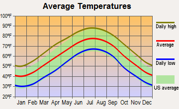
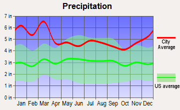
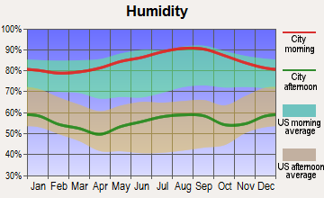
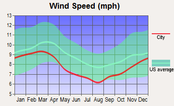
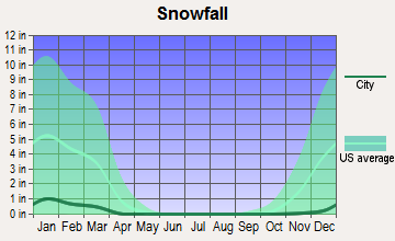
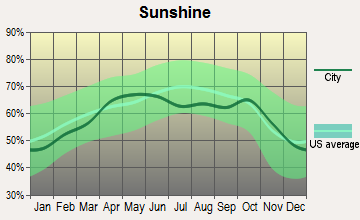
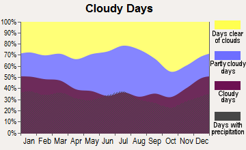
Average climate in Juno, Georgia
Based on data reported by over 4,000 weather stations
(lower is better)
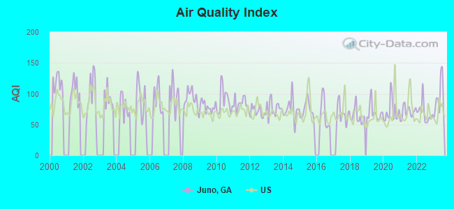
Air Quality Index (AQI) level in 2023 was 93.0. This is worse than average.
| City: | 93.0 |
| U.S.: | 72.6 |
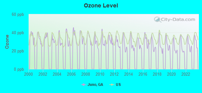
Ozone [ppb] level in 2022 was 27.0. This is better than average. Closest monitor was 0.7 miles away from the city center.
| City: | 27.0 |
| U.S.: | 33.3 |
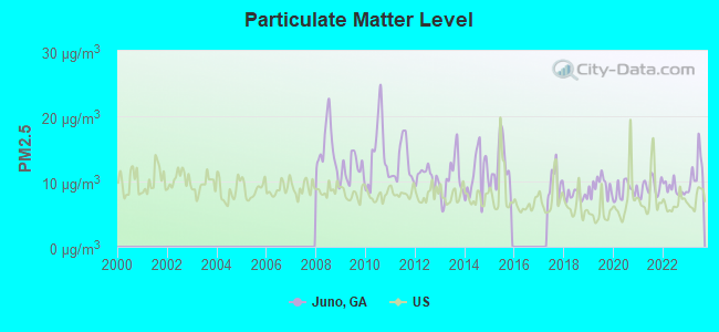
Particulate Matter (PM2.5) [µg/m3] level in 2023 was 11.5. This is significantly worse than average. Closest monitor was 14.5 miles away from the city center.
| City: | 11.5 |
| U.S.: | 8.1 |
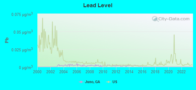
Lead (Pb) [µg/m3] level in 2015 was 0.00139. This is significantly better than average. Closest monitor was 0.7 miles away from the city center.
| City: | 0.00139 |
| U.S.: | 0.00931 |
Tornado activity:
Juno-area historical tornado activity is slightly above Georgia state average. It is 45% greater than the overall U.S. average.
On 4/3/1974, a category F4 (max. wind speeds 207-260 mph) tornado 11.9 miles away from the Juno place center killed 6 people and injured 30 people and caused between $500,000 and $5,000,000 in damages.
On 3/27/1994, a category F4 tornado 14.7 miles away from the place center killed 3 people and injured 20 people and caused between $5,000,000 and $50,000,000 in damages.
Earthquake activity:
Juno-area historical earthquake activity is significantly above Georgia state average. It is 57% greater than the overall U.S. average.On 4/29/2003 at 08:59:39, a magnitude 4.9 (4.4 MB, 4.6 MW, 4.9 LG, Class: Light, Intensity: IV - V) earthquake occurred 90.3 miles away from Juno center
On 8/2/1974 at 08:52:09, a magnitude 4.9 (4.3 MB, 4.9 LG) earthquake occurred 96.0 miles away from the city center
On 11/30/1973 at 07:48:41, a magnitude 4.7 (4.7 MB, 4.6 ML) earthquake occurred 99.2 miles away from Juno center
On 4/29/2003 at 08:59:39, a magnitude 4.6 (4.6 MW, Depth: 12.3 mi) earthquake occurred 90.3 miles away from Juno center
On 8/9/2020 at 12:07:37, a magnitude 5.1 (5.1 MW, Depth: 4.7 mi, Class: Moderate, Intensity: VI - VII) earthquake occurred 221.6 miles away from the city center
On 12/12/2018 at 09:14:43, a magnitude 4.4 (4.4 MW, Depth: 4.9 mi) earthquake occurred 94.3 miles away from the city center
Magnitude types: regional Lg-wave magnitude (LG), body-wave magnitude (MB), local magnitude (ML), moment magnitude (MW)
Natural disasters:
The number of natural disasters in Dawson County (12) is smaller than the US average (15).Major Disasters (Presidential) Declared: 7
Emergencies Declared: 4
Causes of natural disasters: Winter Storms: 4, Hurricanes: 3, Floods: 2, Storms: 2, Tornadoes: 2, Drought: 1, Snowfall: 1, Other: 1 (Note: some incidents may be assigned to more than one category).
Hospitals and medical centers near Juno:
- UNITED HOME CARE OF CUMMING (Home Health Center, about 11 miles away; CUMMING, GA)
- CHESTATEE REGIONAL HOSPITAL Acute Care Hospitals (about 12 miles away; DAHLONEGA, GA)
- LAKESHORE HEIGHTS NH (Nursing Home, about 12 miles away; GAINESVILLE, GA)
- RCG LAKE LANIER (Dialysis Facility, about 13 miles away; GAINESVILLE, GA)
- COMPASSIONATE HEALTHCARE (Hospital, about 13 miles away; GAINESVILLE, GA)
- CUMMING CONVALESCENT HOME (Nursing Home, about 13 miles away; CUMMING, GA)
- CHESTNUT RIDGE NSG AND REHAB CTR (Nursing Home, about 13 miles away; CUMMING, GA)
Colleges/universities with over 2000 students nearest to Juno:
- University of North Georgia (about 12 miles; Dahlonega, GA; Full-time enrollment: 12,445)
- Brenau University (about 15 miles; Gainesville, GA; FT enrollment: 2,341)
- Lanier Technical College (about 15 miles; Oakwood, GA; FT enrollment: 2,435)
- Georgia Gwinnett College (about 27 miles; Lawrenceville, GA; FT enrollment: 7,993)
- Gwinnett Technical College (about 28 miles; Lawrenceville, GA; FT enrollment: 5,138)
- Piedmont College (about 33 miles; Demorest, GA; FT enrollment: 2,251)
- The Art Institute of Atlanta (about 35 miles; Atlanta, GA; FT enrollment: 3,140)
Points of interest:
Notable locations in Juno: War Hill Park (A), Thompson Creek Access Point (B), Blacks Mill (C), Lumpkin Campground (D), Hightower State Nursery (E), Dawson County Fire Department Station 3 (F), Dawson County Fire Department Station 5 (G), Dawson County Fire Department Station 2 (H). Display/hide their locations on the map
Churches in Juno include: Bethel Church (A), Kilough Church (B), Dawsonville Church of God (C), Harmony Church (D), Lebanon Church (E), Liberty Church (F), Mount Vernon Church (G), Pleasant Grove Church (H), Pleasant Hill Church (I). Display/hide their locations on the map
Cemeteries: Salem Church Cemetery (1), Martin Cemetery (2), Byrd Cemetery (3), Palmer Cemetery (4). Display/hide their locations on the map
Reservoirs: Kents Lake (A), Bruce Lake (B), Vandiver Lake (C), Brice Lake (D), Head Lake (E), Girl Scout Camp Echo Lake (F), Thomas Lake (G). Display/hide their locations on the map
Streams, rivers, and creeks: Yellow Creek (A), Amicalola Creek (B), Toto Creek (C), Thompson Creek (D), Sweetwater Creek (E), Snow Creek (F), Shoal Creek (G), Mill Creek (H), Palmer Creek (I). Display/hide their locations on the map
| This place: | 2.7 people |
| Georgia: | 2.6 people |
| This place: | 64.3% |
| Whole state: | 70.7% |
| This place: | 4.7% |
| Whole state: | 4.8% |
Likely homosexual households (counted as self-reported same-sex unmarried-partner households)
- Lesbian couples: 0.2% of all households
- Gay men: 0.3% of all households
| This place: | 7.0% |
| Whole state: | 13.0% |
| This place: | 3.5% |
| Whole state: | 6.1% |
For population 15 years and over in Juno:
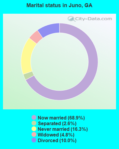
- Never married: 16.3%
- Now married: 68.9%
- Separated: 2.6%
- Widowed: 4.8%
- Divorced: 10.0%
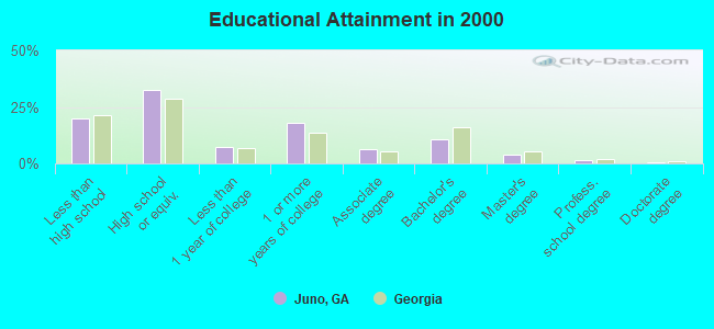
For population 25 years and over in Juno:
- High school or higher: 80.2%
- Bachelor's degree or higher: 16.0%
- Graduate or professional degree: 5.5%
- Unemployed: 3.6%
- Mean travel time to work (commute): 32.6 minutes
| Here: | 10.6 |
| Georgia average: | 13.3 |
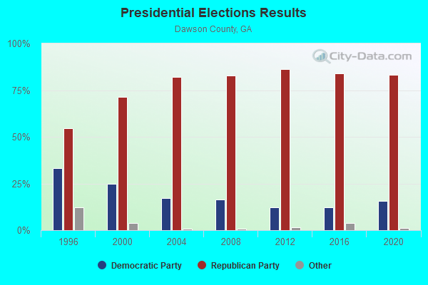
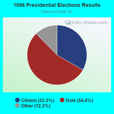
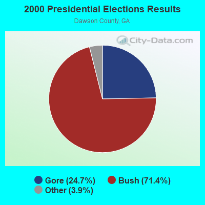

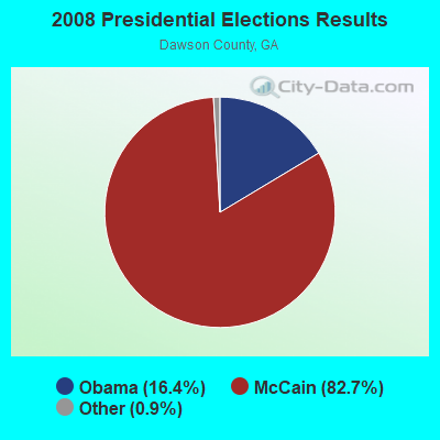
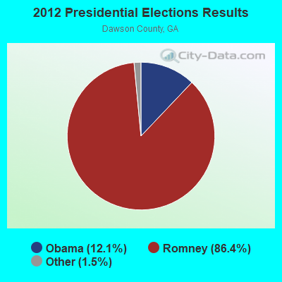
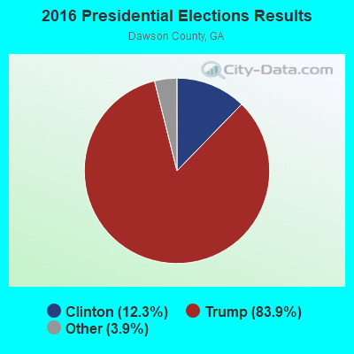
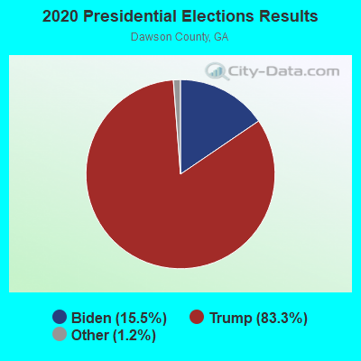
Graphs represent county-level data. Detailed 2008 Election Results
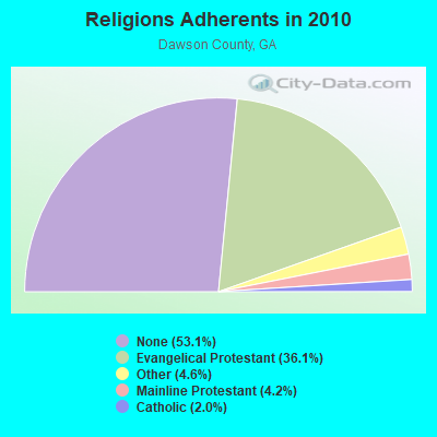
Religion statistics for Juno, GA (based on Dawson County data)
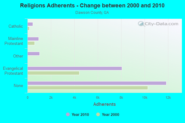
| Religion | Adherents | Congregations |
|---|---|---|
| Evangelical Protestant | 8,060 | 32 |
| Other | 1,035 | 3 |
| Mainline Protestant | 935 | 5 |
| Catholic | 447 | 1 |
| None | 11,853 | - |
Food Environment Statistics:
| This county: | 1.40 / 10,000 pop. |
| Georgia: | 1.91 / 10,000 pop. |
| This county: | 0.93 / 10,000 pop. |
| Georgia: | 0.86 / 10,000 pop. |
| Dawson County: | 2.79 / 10,000 pop. |
| Georgia: | 5.12 / 10,000 pop. |
| This county: | 9.32 / 10,000 pop. |
| State: | 7.41 / 10,000 pop. |
| Dawson County: | 9.4% |
| Georgia: | 10.4% |
| Dawson County: | 26.2% |
| State: | 27.8% |
| Here: | 12.9% |
| State: | 14.6% |
Strongest AM radio stations in Juno:
- WCNN (680 AM; 50 kW; NORTH ATLANTA, GA; Owner: DICKEY BROADCASTING COMPANY)
- WDUN (550 AM; 10 kW; GAINESVILLE, GA; Owner: JWJ PROPERTIRS, INC.)
- WDGR (1210 AM; daytime; 10 kW; DAHLONEGA, GA; Owner: SMALL TOWN RADIO OF GEORGIA, INC.)
- WSB (750 AM; 50 kW; ATLANTA, GA; Owner: CXR HOLDINGS, INC.)
- WGST (640 AM; 50 kW; ATLANTA, GA; Owner: CITICASTERS LICENSES, L.P.)
- WLBA (1130 AM; daytime; 10 kW; GAINESVILLE, GA)
- WFTD (1080 AM; daytime; 50 kW; MARIETTA, GA; Owner: PRIETO ENTERPRISES, INC.)
- WGUN (1010 AM; 50 kW; ATLANTA, GA; Owner: WGUN, INC.)
- WGTJ (1330 AM; 1 kW; MURRAYVILLE, GA; Owner: VISION COMMUNICATIONS, INC.)
- WQXI (790 AM; 28 kW; ATLANTA, GA; Owner: JEFFERSON-PILOT COMMUNICATIONS COMPANY OF GEORGIA)
- WAZX (1550 AM; 50 kW; SMYRNA, GA; Owner: GA-MEX BROADCASTING, INC.)
- WMLB (1160 AM; 50 kW; EAST POINT, GA; Owner: ATLANTA AREA BROADCASTING, INC.)
- WAOK (1380 AM; 50 kW; ATLANTA, GA; Owner: INFINITY BROADCASTING OPERATIONS, INC.)
Strongest FM radio stations in Juno:
- WWEV-FM (91.5 FM; CUMMING, GA; Owner: CURRICULUM DEVELOPMENT FOUNDATION)
- WFOX (97.1 FM; GAINESVILLE, GA; Owner: COX RADIO, INC.)
- WYAY (106.7 FM; GAINESVILLE, GA; Owner: ABC, INC.)
- WNGC (106.1 FM; TOCCOA, GA; Owner: SOUTHERN BROADCASTING OF PENSACOLA, INC)
- WNGU (89.5 FM; DAHLONEGA, GA; Owner: GEORGIA PUBLIC TELECOMMUNICATIONS COMMISSION)
- WBCX (89.1 FM; GAINESVILLE, GA; Owner: BRENAU COLLEGE)
- W221AW (92.1 FM; NORTH CANTON, GA; Owner: IMMANUEL BROADCASTING NETWORK, INC.)
- W214AS (90.7 FM; WALESKA, GA; Owner: CALVARY CHAPEL OF TWIN FALLS, INC.)
- WFSH-FM (104.7 FM; ATHENS, GA; Owner: SOUTH TEXAS BROADCASTING, INC.)
- WCON-FM (99.3 FM; CORNELIA, GA; Owner: HABERSHAM BROADCASTING CO.)
- WKHC (104.3 FM; DAHLONEGA, GA; Owner: WILLIAMS COMMUNICATIONS, INC.)
- W234AG (94.7 FM; CHATSWORTH, GA; Owner: IMMANUEL BROADCASTING NETWORK, INC.)
- WBTS (95.5 FM; ATHENS, GA; Owner: CXR HOLDINGS, INC.)
- WFQS (91.3 FM; FRANKLIN, NC; Owner: WESTERN NORTH CAROLINA PUBLIC RADIO)
- WPPR (88.3 FM; DEMOREST, GA; Owner: GEORGIA PUBLIC TELECOMMUNICATIONS COMMISSION)
- WLKQ-FM (102.3 FM; BUFORD, GA; Owner: LAKE RADIO, INC.)
- WLCL (105.7 FM; CANTON, GA; Owner: CHEROKEE BROADCASTING CO., INC.)
- WCVP-FM (95.9 FM; ROBBINSVILLE, NC; Owner: CHEROKEE BROADCASTING COMPANY, INC.)
- W265BD (100.9 FM; WOODSTOCK, GA; Owner: IMMANUEL BROADCASTING NETWORK, INC.)
- WKHX-FM (101.5 FM; MARIETTA, GA; Owner: ABC, INC.)
TV broadcast stations around Juno:
- W50AB (Channel 50; HIAWASSEE, GA; Owner: GEORGIA PUBLIC TELECOMMUNICATIONS COMMISSION)
- WUVG (Channel 34; ATHENS, GA; Owner: UNIVISION ATLANTA LLC)
- WAGA (Channel 5; ATLANTA, GA; Owner: FOX TELEVISION STATIONS, INC.)
- WSKC-LP (Channel 59; ATLANTA, GA; Owner: KM LPTV OF ATLANTA, L.L.C.)
- WTBS (Channel 17; ATLANTA, GA; Owner: SUPERSTATION, INC.)
- WATL (Channel 36; ATLANTA, GA; Owner: WATL, LLC)
- WGCL-TV (Channel 46; ATLANTA, GA; Owner: MEREDITH CORPORATION)
- WPXA (Channel 14; ROME, GA; Owner: PAXSON ATLANTA LICENSE, INC.)
- WHSG (Channel 63; MONROE, GA; Owner: TRINITY BROADCASTING NETWORK)
- WPBA (Channel 30; ATLANTA, GA; Owner: BOARD OF EDUCATION OF THE CITY OF ATLANTA)
Juno fatal accident list:
FCC Registered Broadcast Land Mobile Towers:
3- 1 1/2 Mi N Of Hwy 52 Amicalola Falls State Park (Lat: 34.569528 Lon: -84.239083), Structure height: 3 m, Call Sign: WNYW373,
Assigned Frequencies: 173.287 MHz, Grant Date: 02/23/2022, Expiration Date: 03/24/2032, Registrant: Gta-Dnr-Amicalola Falls Sp, 2600 Hwy 155 Sw, Stockbridge, GA 30281, Phone: (706) 878-4737, Email:
- Pump House Amicalola Falls State Park (Lat: 34.570639 Lon: -84.245472), Call Sign: WXF896,
Assigned Frequencies: 31.1000 MHz, 31.1400 MHz, Grant Date: 01/13/2015, Expiration Date: 03/28/2025, Registrant: Gta- Dnr Amicalola State Park, 47 Trinity Ave Sw 3rd Floor, Atlanta, GA 30334, Phone: (404) 656-2042, Fax: (404) 657-0320, Email:
- Lat: 34.446639 Lon: -84.176917, Call Sign: KFG428,
Assigned Frequencies: 158.947 MHz, Grant Date: 05/18/2023, Expiration Date: 06/11/2033, Certifier: Wray Hall, Registrant: Gta Dps Coal Mntn Post #37, 47 Trinity Ave Sw 4th Floor, Atlanta, GA 30334, Phone: (404) 656-2042, Fax: (404) 657-0320, Email:
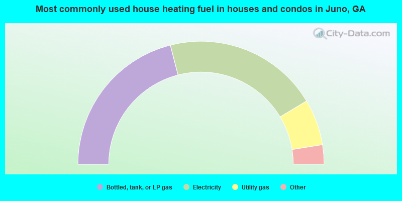
- 42.0%Bottled, tank, or LP gas
- 40.8%Electricity
- 12.1%Utility gas
- 2.6%Fuel oil, kerosene, etc.
- 2.3%Wood
- 0.2%Other fuel
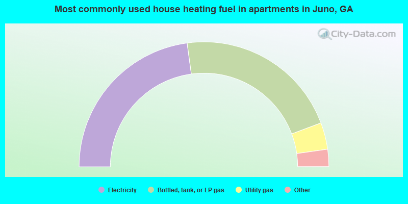
- 45.7%Electricity
- 42.9%Bottled, tank, or LP gas
- 6.9%Utility gas
- 3.7%Fuel oil, kerosene, etc.
- 0.8%Wood
Juno compared to Georgia state average:
- Unemployed percentage significantly below state average.
- Black race population percentage significantly below state average.
- Hispanic race population percentage significantly below state average.
- Median age below state average.
- Foreign-born population percentage significantly below state average.
- Renting percentage significantly below state average.
- Length of stay since moving in significantly above state average.
- Number of rooms per house significantly below state average.
- House age significantly below state average.
- Number of college students below state average.
Juno on our top lists:
- #8 on the list of "Top 101 cities with largest percentage of females in occupations: printing workers (population 5,000+)"
- #8 on the list of "Top 101 cities with largest percentage of females in occupations: woodworkers (population 5,000+)"
- #18 on the list of "Top 101 cities with largest percentage of females in occupations: bus drivers (population 5,000+)"
- #20 on the list of "Top 101 cities with largest percentage of females in industries: wood products (population 5,000+)"
- #22 on the list of "Top 101 cities with largest percentage of males in occupations: supervisors of construction and extraction workers (population 5,000+)"
- #28 on the list of "Top 101 cities with largest percentage of males in industries: lumber and other construction materials merchant wholesalers (population 5,000+)"
- #31 on the list of "Top 101 cities with largest percentage of females in occupations: accountants and auditors (population 5,000+)"
- #46 on the list of "Top 101 cities with largest percentage of females in industries: textile mills and textile products (population 5,000+)"
- #47 on the list of "Top 101 cities with largest percentage of females in industries: fuel dealers (population 5,000+)"
- #51 on the list of "Top 101 cities with largest percentage of females in occupations: other sales and related workers including supervisors (population 5,000+)"
- #54 on the list of "Top 101 cities with largest percentage of males in industries: clothing and accessories, including shoe, stores (population 5,000+)"
- #58 on the list of "Top 101 cities with largest percentage of females in industries: electrical and electronic goods merchant wholesalers (population 5,000+)"
- #59 on the list of "Top 101 cities with largest percentage of females in industries: motor vehicle and parts dealers (population 5,000+)"
- #61 on the list of "Top 101 cities with largest percentage of females in industries: retail florists (population 5,000+)"
- #64 on the list of "Top 101 cities with largest percentage of males in industries: textile mills and textile products (population 5,000+)"
- #74 on the list of "Top 101 cities with largest percentage of males in industries: private households (population 5,000+)"
- #80 on the list of "Top 101 cities with largest percentage of females in industries: food and beverage stores (population 5,000+)"
- #82 on the list of "Top 101 cities with largest percentage of males in industries: furniture and home furnishings, and household appliance stores (population 5,000+)"
- #87 on the list of "Top 101 cities with largest percentage of males in industries: miscellaneous durable goods merchant wholesalers (population 5,000+)"
- #99 on the list of "Top 101 cities with largest percentage of females in industries: social assistance (population 5,000+)"
- #11 on the list of "Top 101 counties with the lowest lead air pollution readings in 2012 (µg/m3)"
- #18 on the list of "Top 101 counties with the highest lead air pollution readings in 2012 (µg/m3)"
- #52 on the list of "Top 101 counties with highest percentage of residents voting for Romney (Republican) in the 2012 Presidential Election"