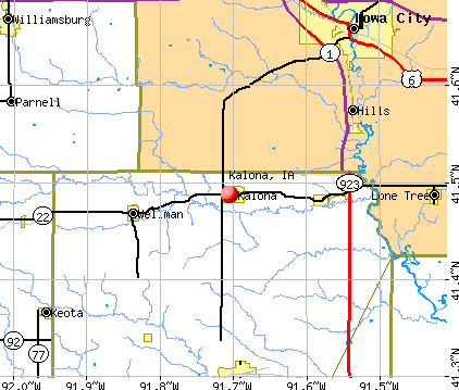
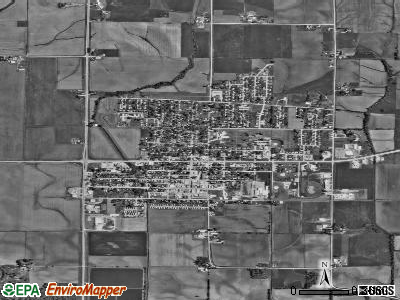
Kalona, Iowa
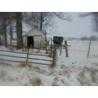
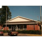
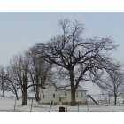
Submit your own pictures of this city and show them to the world
- OSM Map
- General Map
- Google Map
- MSN Map
Population change since 2000: +18.1%
 |
| Males: 1,355 | |
| Females: 1,354 |
| Median resident age: | 41.6 years |
| Iowa median age: | 38.9 years |
Zip codes: 52247.
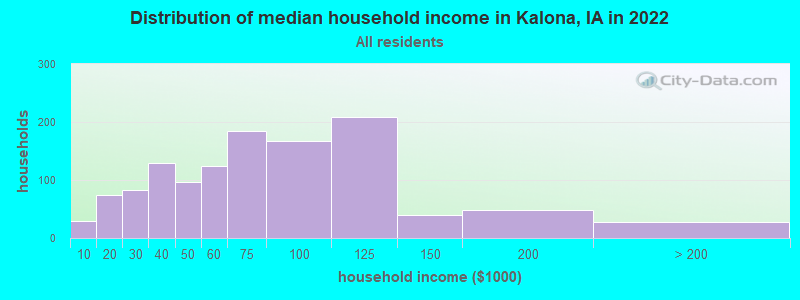
| Kalona: | $66,868 |
| IA: | $69,588 |
Estimated per capita income in 2022: $39,029 (it was $22,474 in 2000)
Kalona city income, earnings, and wages data
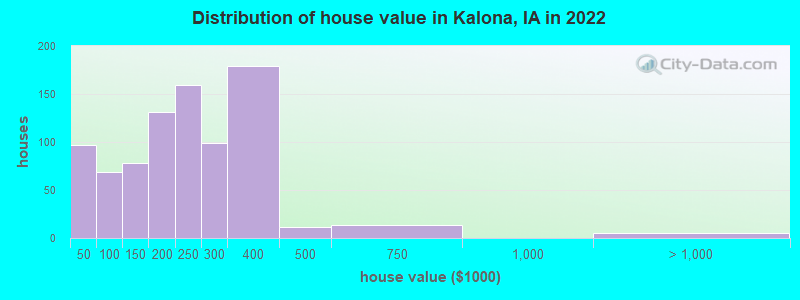
Estimated median house or condo value in 2022: $224,819 (it was $91,800 in 2000)
| Kalona: | $224,819 |
| IA: | $194,600 |
Mean prices in 2022: all housing units: $214,493; detached houses: $233,408; townhouses or other attached units: $213,203; in 2-unit structures: $141,923; mobile homes: $12,851
Median gross rent in 2022: $780.
(3.7% for White Non-Hispanic residents, 27.5% for Hispanic or Latino residents, 100.0% for other race residents)
Detailed information about poverty and poor residents in Kalona, IA
Compare current foreclosures near Kalona, IA:
| Photo | Address | Area | Beds / Baths | Price | Details |
|---|---|---|---|---|---|

|
#1
12th St
Kalona, IA 52247
|
2,114 sq. feet
|
2 baths 3 beds |
show details | |

|
#2
Howard St
Kalona, IA 52247
|
987 sq. feet
|
1 baths 2 beds |
show details | |

|
#3
Douglass St
Iowa City, IA 52246
|
924 sq. feet
|
1 baths 2 beds |
$189,900
|
show details |

|
#4
W Dougherty Dr
Lone Tree, IA 52755
|
1,844 sq. feet
|
3 baths 3 beds |
show details | |

|
#5
Burns Ave
Iowa City, IA 52240
|
1,044 sq. feet
|
2 baths 3 beds |
show details | |

|
#6
E Grantview Dr
Coralville, IA 52241
|
1,687 sq. feet
|
4 baths 4 beds |
show details | |

|
#7
James Blvd Nw, Apt 3
Oxford, IA 52322
|
931 sq. feet
|
1 baths 2 beds |
show details | |

|
#8
Holiday Rd Apt 3
Coralville, IA 52241
|
2,275 sq. feet
|
3 baths 4 beds |
show details | |

|
#9
Coral Ct Apt 104
Coralville, IA 52241
|
910 sq. feet
|
1 baths 2 beds |
show details | |

|
#10
Kimberlite St
Tiffin, IA 52340
|
1,235 sq. feet
|
2 baths 3 beds |
show details |
| Photo | Address | Area | Beds / Baths | Price | Details |
|---|---|---|---|---|---|

|
#11
14th Ave
Coralville, IA 52241
|
1,120 sq. feet
|
1 baths 3 beds |
show details | |

|
#12
11th Ave
Coralville, IA 52241
|
768 sq. feet
|
1 baths 2 beds |
show details | |

|
#13
Forest Edge Dr
Coralville, IA 52241
|
2,406 sq. feet
|
3 baths 3 beds |
show details | |

|
#14
Lloyd Ave SE
Iowa City, IA 52240
|
1,332 sq. feet
|
2 baths 3 beds |
show details | |

|
#15
S Avenue D
Washington, IA 52353
|
1,826 sq. feet
|
- baths 3 beds |
show details | |

|
#16
5th St
Wellman, IA 52356
|
660 sq. feet
|
- baths 2 beds |
show details | |

|
#17
Kimball Rd
Iowa City, IA 52245
|
988 sq. feet
|
- baths 8 beds |
show details | |

|
#18
2nd Ave
Iowa City, IA 52240
|
925 sq. feet
|
- baths 7 beds |
show details | |

|
#19
W 6th St
Washington, IA 52353
|
1,146 sq. feet
|
- baths 3 beds |
show details | |

|
#20
S Iowa Ave
Washington, IA 52353
|
1,181 sq. feet
|
- baths 3 beds |
show details |
| Photo | Address | Area | Beds / Baths | Price | Details |
|---|---|---|---|---|---|

|
#21
Grantwood St
Iowa City, IA 52240
|
1,040 sq. feet
|
- baths 6 beds |
show details | |

|
#22
E 3rd St
Washington, IA 52353
|
1,728 sq. feet
|
- baths 3 beds |
show details | |

|
#23
Hollywood Ct
Iowa City, IA 52240
|
828 sq. feet
|
- baths 5 beds |
show details | |

|
#24
Lexington Ave
Iowa City, IA 52246
|
2,508 sq. feet
|
- baths 8 beds |
show details | |

|
#25
E Jefferson St
Washington, IA 52353
|
1,503 sq. feet
|
- baths 3 beds |
show details | |

|
#26
Hemingway Ln
Iowa City, IA 52240
|
1,656 sq. feet
|
- baths 9 beds |
show details | |

|
#27
S 9th Ave
Washington, IA 52353
|
1,821 sq. feet
|
- baths 3 beds |
show details | |

|
#28
S C Ave
Washington, IA 52353
|
1,017 sq. feet
|
- baths 3 beds |
show details | |

|
#29
Regal Ln
Iowa City, IA 52240
|
913 sq. feet
|
- baths 6 beds |
show details | |

|
#30
Davis St
Iowa City, IA 52240
|
- sq. feet
|
- baths - beds |
show details |
| Photo | Address | Area | Beds / Baths | Price | Details |
|---|---|---|---|---|---|

|
#31
Melrose Ave
Iowa City, IA 52246
|
2,708 sq. feet
|
- baths - beds |
show details | |

|
#32
130th St
Riverside, IA 52327
|
- sq. feet
|
- baths - beds |
show details | |

|
#33
Scott Park Dr Apt 203
Iowa City, IA 52245
|
- sq. feet
|
- baths - beds |
show details | |

|
#34
Westwinds Dr Apt 1
Iowa City, IA 52246
|
- sq. feet
|
- baths - beds |
show details | |

|
#35
225th St
Williamsburg, IA 52361
|
- sq. feet
|
- baths - beds |
show details | |

|
#36
Highland Ave
Washington, IA 52353
|
- sq. feet
|
- baths - beds |
show details | |

|
#37
Oakcrest St Apt 1
Iowa City, IA 52246
|
- sq. feet
|
- baths - beds |
show details | |

|
#38
Rolling Hills Dr
Tiffin, IA 52340
|
- sq. feet
|
- baths - beds |
show details | |

|
#39
Bear Dr
Tiffin, IA 52340
|
1,597 sq. feet
|
- baths - beds |
show details | |

|
#40
Calla Lilly Way
Tiffin, IA 52340
|
- sq. feet
|
- baths - beds |
show details |
| Photo | Address | Area | Beds / Baths | Price | Details |
|---|---|---|---|---|---|

|
#41
Hotz Ave
Iowa City, IA 52245
|
- sq. feet
|
- baths - beds |
show details | |

|
#42
2nd St Trlr 66
Coralville, IA 52241
|
- sq. feet
|
- baths - beds |
show details | |

|
#43
Paddock Cir
Iowa City, IA 52240
|
- sq. feet
|
- baths - beds |
show details | |

|
#44
1st Ave Apt C-205n
Coralville, IA 52241
|
- sq. feet
|
- baths - beds |
show details | |

|
#45
S Dubuque St # 303
Iowa City, IA 52240
|
- sq. feet
|
- baths - beds |
show details | |

|
#46
14th St
Coralville, IA 52241
|
- sq. feet
|
- baths - beds |
show details | |

|
#47
Aniston St
Iowa City, IA 52240
|
- sq. feet
|
- baths - beds |
show details | |

|
#48
Apple Ct
Iowa City, IA 52240
|
- sq. feet
|
- baths - beds |
show details | |

|
#49
Highway 6 E Lot 20
Iowa City, IA 52240
|
- sq. feet
|
- baths - beds |
show details | |

|
Check over 1 million property listings on Foreclosure.com!
|
browse all offers | |||


- 2,42391.6%White alone
- 1495.6%Two or more races
- 722.7%Hispanic
- 20.08%Asian alone
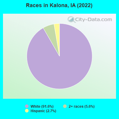
Races in Kalona detailed stats: ancestries, foreign born residents, place of birth
According to our research of Iowa and other state lists, there were 8 registered sex offenders living in Kalona, Iowa as of May 25, 2024.
The ratio of all residents to sex offenders in Kalona is 313 to 1.
 Recent articles from our blog. Our writers, many of them Ph.D. graduates or candidates, create easy-to-read articles on a wide variety of topics.

 | Driving I-80 across Iowa question (34 replies) |
| Dream town in Iowa (34 replies) |
| Is Eastern Iowa right for us? (28 replies) |
| Who carries Sauder Furniture? Inexpensive end tables? (18 replies) |
| Expansion of beer breweries in Eastern Iowa (3 replies) |
| From germany to iowa (6 replies) |
Latest news from Kalona, IA collected exclusively by city-data.com from local newspapers, TV, and radio stations
Ancestries: German (46.0%), European (7.1%), American (6.1%), Swedish (5.6%), Irish (5.2%), Norwegian (3.8%).
Current Local Time: CST time zone
Incorporated on 05/22/1890
Elevation: 662 feet
Land area: 2.05 square miles.
Population density: 1,323 people per square mile (low).
100 residents are foreign born (1.8% Europe, 1.8% Latin America).
| This city: | 3.8% |
| Iowa: | 5.6% |
Median real estate property taxes paid for housing units with mortgages in 2022: $2,782 (1.2%)
Median real estate property taxes paid for housing units with no mortgage in 2022: $3,464 (1.6%)
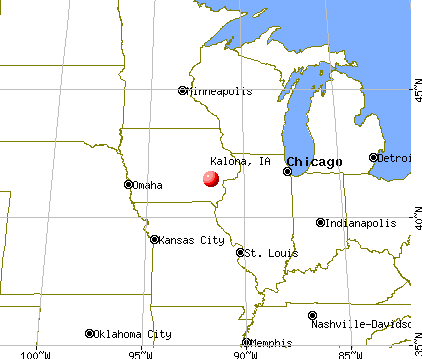
Nearest city with pop. 50,000+: Iowa City, IA  (15.0 miles , pop. 62,220).
Nearest city with pop. 200,000+: Madison, WI (161.4 miles , pop. 208,054).
Nearest city with pop. 1,000,000+: Chicago, IL (209.4 miles , pop. 2,896,016).
Nearest cities:
), ), ), Latitude: 41.49 N, Longitude: 91.71 W
Area code: 319
Single-family new house construction building permits:
- 2022: 20 buildings, average cost: $137,700
- 2021: 24 buildings, average cost: $137,700
- 2020: 23 buildings, average cost: $137,700
- 2019: 18 buildings, average cost: $137,700
- 2018: 19 buildings, average cost: $137,700
- 2017: 17 buildings, average cost: $137,700
- 2016: 16 buildings, average cost: $137,700
- 2015: 16 buildings, average cost: $137,700
- 2014: 14 buildings, average cost: $137,700
- 2013: 13 buildings, average cost: $137,700
- 2012: 11 buildings, average cost: $137,700
- 2011: 9 buildings, average cost: $137,700
- 2010: 10 buildings, average cost: $137,700
- 2009: 11 buildings, average cost: $137,700
- 2008: 14 buildings, average cost: $137,700
- 2007: 14 buildings, average cost: $150,600
- 2006: 11 buildings, average cost: $207,800
- 2005: 21 buildings, average cost: $138,200
- 2004: 4 buildings, average cost: $167,500
- 2003: 15 buildings, average cost: $144,000
- 2002: 8 buildings, average cost: $126,500
- 2001: 10 buildings, average cost: $148,900
- 2000: 14 buildings, average cost: $127,100
- 1999: 4 buildings, average cost: $101,300
- 1998: 8 buildings, average cost: $142,500
- 1997: 8 buildings, average cost: $129,900
| Here: | 2.1% |
| Iowa: | 2.7% |
- Health care (21.7%)
- Educational services (12.0%)
- Construction (9.9%)
- Finance & insurance (5.0%)
- Food & beverage stores (3.8%)
- Food (2.7%)
- Broadcasting & telecommunications (2.6%)
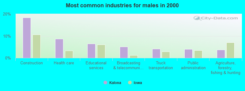
- Construction (18.3%)
- Health care (8.7%)
- Educational services (6.4%)
- Broadcasting & telecommunications (5.1%)
- Truck transportation (4.2%)
- Public administration (4.0%)
- Agriculture, forestry, fishing & hunting (3.8%)
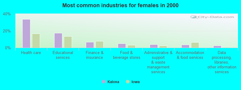
- Health care (33.7%)
- Educational services (17.2%)
- Finance & insurance (6.6%)
- Food & beverage stores (5.0%)
- Administrative & support & waste management services (3.8%)
- Accommodation & food services (3.7%)
- Data processing, libraries, other information services (2.6%)
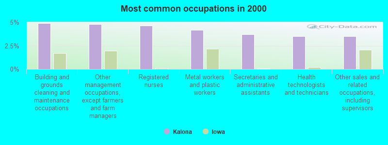
- Building and grounds cleaning and maintenance occupations (4.9%)
- Other management occupations, except farmers and farm managers (4.8%)
- Registered nurses (4.6%)
- Metal workers and plastic workers (4.2%)
- Secretaries and administrative assistants (3.7%)
- Health technologists and technicians (3.5%)
- Other sales and related occupations, including supervisors (3.5%)
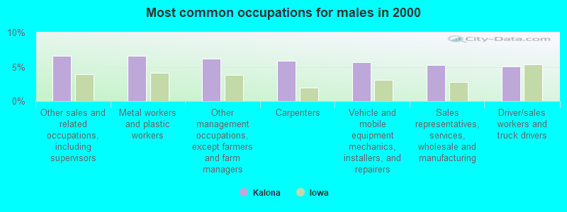
- Other sales and related occupations, including supervisors (6.6%)
- Metal workers and plastic workers (6.6%)
- Other management occupations, except farmers and farm managers (6.2%)
- Carpenters (5.8%)
- Vehicle and mobile equipment mechanics, installers, and repairers (5.7%)
- Sales representatives, services, wholesale and manufacturing (5.3%)
- Driver/sales workers and truck drivers (5.1%)
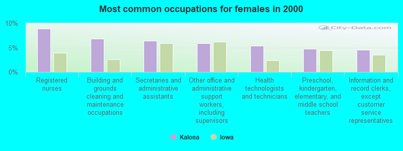
- Registered nurses (8.9%)
- Building and grounds cleaning and maintenance occupations (6.8%)
- Secretaries and administrative assistants (6.4%)
- Other office and administrative support workers, including supervisors (5.9%)
- Health technologists and technicians (5.4%)
- Preschool, kindergarten, elementary, and middle school teachers (4.7%)
- Information and record clerks, except customer service representatives (4.5%)
Average climate in Kalona, Iowa
Based on data reported by over 4,000 weather stations


|
|

(lower is better)
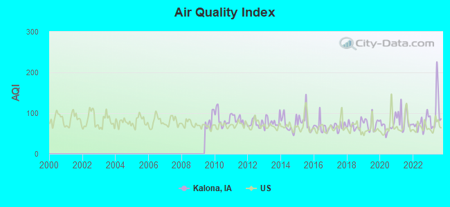
Air Quality Index (AQI) level in 2023 was 103. This is significantly worse than average.
| City: | 103 |
| U.S.: | 73 |
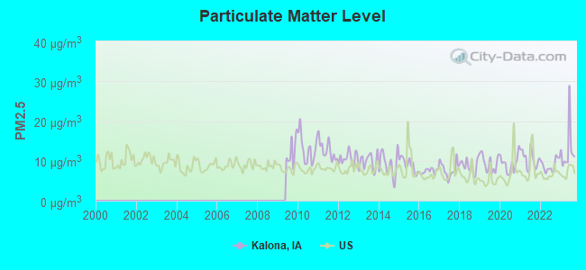
Particulate Matter (PM2.5) [µg/m3] level in 2023 was 12.8. This is significantly worse than average. Closest monitor was 15.7 miles away from the city center.
| City: | 12.8 |
| U.S.: | 8.1 |
Tornado activity:
Kalona-area historical tornado activity is near Iowa state average. It is 89% greater than the overall U.S. average.
On 6/7/1984, a category F4 (max. wind speeds 207-260 mph) tornado 9.9 miles away from the Kalona city center killed 3 people and injured 64 people and caused between $5,000,000 and $50,000,000 in damages.
On 8/12/1974, a category F4 tornado 30.6 miles away from the city center injured 2 people and caused between $50,000 and $500,000 in damages.
Earthquake activity:
Kalona-area historical earthquake activity is significantly above Iowa state average. It is 161% greater than the overall U.S. average.On 4/18/2008 at 09:36:59, a magnitude 5.4 (5.1 MB, 4.8 MS, 5.4 MW, 5.2 MW, Class: Moderate, Intensity: VI - VII) earthquake occurred 291.6 miles away from the city center
On 4/18/2008 at 09:36:59, a magnitude 5.2 (5.2 MW, Depth: 8.9 mi) earthquake occurred 291.6 miles away from the city center
On 6/10/1987 at 23:48:54, a magnitude 5.1 (4.9 MB, 4.4 MS, 4.6 MS, 5.1 LG) earthquake occurred 273.4 miles away from the city center
On 6/28/2004 at 06:10:52, a magnitude 4.2 (4.2 MW, Depth: 6.2 mi, Class: Light, Intensity: IV - V) earthquake occurred 145.4 miles away from Kalona center
On 9/3/2016 at 12:02:44, a magnitude 5.8 (5.8 MW, Depth: 3.5 mi) earthquake occurred 448.7 miles away from Kalona center
On 6/18/2002 at 17:37:15, a magnitude 5.0 (4.3 MB, 4.6 MW, 5.0 LG) earthquake occurred 319.6 miles away from Kalona center
Magnitude types: regional Lg-wave magnitude (LG), body-wave magnitude (MB), surface-wave magnitude (MS), moment magnitude (MW)
Natural disasters:
The number of natural disasters in Washington County (14) is near the US average (15).Major Disasters (Presidential) Declared: 12
Emergencies Declared: 1
Causes of natural disasters: Floods: 9, Storms: 7, Tornadoes: 5, Winter Storms: 2, Hurricane: 1, Wind: 1, Other: 1 (Note: some incidents may be assigned to more than one category).

Hospitals and medical centers in Kalona:
Other hospitals and medical centers near Kalona:
- VISITING NURSE ASSOCIATION OF JOHNSON COUNTY (Home Health Center, about 13 miles away; IOWA CITY, IA)
- HOSPICE OF WASHINGTON COUNTY (Hospital, about 13 miles away; WASHINGTON, IA)
- WASHINGTON CO. PUBLIC HEALTH (Home Health Center, about 13 miles away; WASHINGTON, IA)
- UNITED PRESBYTERIAN HOME (Nursing Home, about 14 miles away; WASHINGTON, IA)
- HALCYON HOUSE (Nursing Home, about 14 miles away; WASHINGTON, IA)
- WASHINGTON COUNTY HOSPITAL AND CLINICS Critical Access Hospitals (about 14 miles away; WASHINGTON, IA)
- UNIVERSITY OF IOWA HOSPITAL AND CLINICS - WASHINGTON (Dialysis Facility, about 14 miles away; WASHINGTON, IA)
College/University in Kalona:
Colleges/universities with over 2000 students nearest to Kalona:
- University of Iowa (about 15 miles; Iowa City, IA; Full-time enrollment: 24,735)
- Kirkwood Community College (about 30 miles; Cedar Rapids, IA; FT enrollment: 11,503)
- Indian Hills Community College (about 48 miles; Ottumwa, IA; FT enrollment: 4,034)
- Southeastern Community College (about 55 miles; West Burlington, IA; FT enrollment: 2,251)
- Saint Ambrose University (about 59 miles; Davenport, IA; FT enrollment: 3,053)
- Eastern Iowa Community College District (about 59 miles; Davenport, IA; FT enrollment: 5,507)
- Augustana College (about 60 miles; Rock Island, IL; FT enrollment: 2,555)
Private high schools in Kalona:
- IOWA MENNONITE SCHOOL (Students: 108, Location: 1421 540TH ST SW, Grades: 9-12)
- PATHWAY CHRISTIAN SCHOOL (Students: 59, Location: 5764 HIGHWAY 1 SW, Grades: KG-12)
Public elementary/middle schools in Kalona:
- MID-PRAIRIE MIDDLE SCHOOL (Students: 322, Location: 713 F AVE, Grades: 6-8)
- KALONA ELEMENTARY SCHOOL (Students: 244, Location: 702 6TH ST, Grades: PK-5)
- WASHINGTON TOWNSHIP ELEMENTARY SCHOOL (Students: 115, Location: 1592 ANGLE RD. SW, Grades: PK-5)
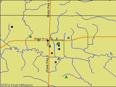
Points of interest:
Notable locations in Kalona: Kalona Historical Village (A), Kalona Public Library (B), Kalona City Community Center (C), Kalona City Hall (D), Kalona Volunteer Fire Department (E). Display/hide their locations on the map
Churches in Kalona include: Grace Fellowship Church (A), Sacred Heart Catholic Church (B), Methodist Church (C), Kalona Mennonite Church (D), Kalona Christian Fellowship (E), Sunnyside Mennonite Church (F), United Christian and Baptist Church (G), Full Gospel Revival Center (H). Display/hide their locations on the map
Cemetery: Sharon Hill Cemetery (1). Display/hide its location on the map
Park in Kalona: Kalona City Park (1). Display/hide its location on the map
Tourist attractions: Mennonite Museum & Archives (715 D Avenue), Kalona Kritters (Cultural Attractions- Events- & Facilities; 401 5th Street), Rainbow Balloonport (Amusement & Theme Parks; 2738 500th Street Southwest), Kalona Historical Society Tours (Tours & Charters; 2074 Highway 22).
Hotels: Pull'r Inn Motel (110 E Avenue), Motel-Pull'R Inn (110 E Avenue).
Drinking water stations with addresses in Kalona and their reported violations in the past:
TWIN COUNTIES DAIRY, LLC (Address: 2206 540TH ST SW , Population served: 262, Groundwater):Past health violations:UPPER DEER CREEK CHURCH (Address: 4995 WATERWAY LANE SW , Population served: 200, Groundwater):Past monitoring violations:
- MCL, Single Sample - In SEP-2010, Contaminant: Nitrite. Follow-up actions: St Public Notif requested (SEP-10-2010), St Formal NOV issued (SEP-10-2010), St Public Notif received (SEP-14-2010), St Compliance achieved (JAN-05-2011)
- MCL, Single Sample - Between JUL-2009 and JUN-2010, Contaminant: Nitrite. Follow-up actions: St Public Notif requested (APR-09-2010), St Formal NOV issued (APR-09-2010), St Public Notif received (APR-15-2010), St Compliance achieved (JAN-05-2011)
- One minor monitoring violation
- 2 regular monitoring violations
Past health violations:FRYTOWN WATER COOP (Address: 4995 WATERWAY LN SW , Population served: 87, Groundwater):
- MCL, Monthly (TCR) - Between OCT-2006 and DEC-2006, Contaminant: Coliform. Follow-up actions: St Violation/Reminder Notice (DEC-18-2006), St Public Notif requested (DEC-21-2006), St Formal NOV issued (DEC-21-2006), St Public Notif received (JAN-19-2007), St Compliance achieved (2 times from MAY-17-2007 to MAY-17-2007)
Past health violations:SYLVIA ROPP HOME (Address: 1024 IVY AVE , Population served: 47, Groundwater):Past monitoring violations:
- MCL, Monthly (TCR) - In JUN-2010, Contaminant: Coliform. Follow-up actions: St Violation/Reminder Notice (JUN-17-2010), St Public Notif requested (JUN-23-2010), St Formal NOV issued (JUN-23-2010), St Compliance achieved (NOV-10-2010), St Public Notif received (JUN-27-2011)
- MCL, Monthly (TCR) - In JUN-2008, Contaminant: Coliform. Follow-up actions: St Violation/Reminder Notice (JUN-16-2008), St Public Notif requested (NOV-24-2008), St Formal NOV issued (NOV-24-2008), St Public Notif received (DEC-05-2008), St Compliance achieved (DEC-16-2008)
- MCL, Monthly (TCR) - In AUG-2007, Contaminant: Coliform. Follow-up actions: St Violation/Reminder Notice (AUG-17-2007), St Public Notif requested (AUG-22-2007), St Formal NOV issued (AUG-22-2007), St Public Notif received (SEP-13-2007), St Compliance achieved (FEB-12-2008)
- MCL, Monthly (TCR) - In AUG-2006, Contaminant: Coliform. Follow-up actions: St Violation/Reminder Notice (AUG-25-2006), St Public Notif requested (AUG-30-2006), St Formal NOV issued (AUG-30-2006), St Public Notif received (SEP-30-2006), St Compliance achieved (FEB-21-2007)
- MCL, Monthly (TCR) - In NOV-2005, Contaminant: Coliform. Follow-up actions: St Violation/Reminder Notice (NOV-04-2005), St Formal NOV issued (NOV-14-2005), St Public Notif requested (NOV-14-2005), St Compliance achieved (MAY-25-2006)
- One routine major monitoring violation
Past monitoring violations:LACINA MEADOWS RESIDENTIAL SUBDIVISION (Address: 4995 WATERWAY LN , Population served: 42, Groundwater):
- 2 routine major monitoring violations
- One minor monitoring violation
Past health violations:STRINGTOWN GROCERY (Address: 2300 540TH ST , Population served: 39, Purch groundwater):Past monitoring violations:
- MCL, Average - Between JAN-2013 and MAR-2013, Contaminant: Combined Radium (-226 and -228). Follow-up actions: St BCA signed (NOV-14-2007), St AO (w/o penalty) issued (NOV-14-2007), St BCA signed (3 times from NOV-14-2007 to OCT-13-2008), St AO (w/o penalty) issued (OCT-13-2008), St Public Notif requested (MAR-22-2013), St Formal NOV issued (MAR-22-2013), St Public Notif received (APR-10-2013)
- MCL, Average - Between JAN-2013 and MAR-2013, Contaminant: Gross Alpha, Excl. Radon and U. Follow-up actions: St BCA signed (NOV-14-2007), St AO (w/o penalty) issued (NOV-14-2007), St BCA signed (3 times from NOV-14-2007 to OCT-13-2008), St AO (w/o penalty) issued (OCT-13-2008), St Public Notif requested (MAR-13-2013), St Formal NOV issued (MAR-13-2013), St Public Notif received (MAR-21-2013)
- MCL, Average - Between OCT-2012 and DEC-2012, Contaminant: Gross Alpha, Excl. Radon and U. Follow-up actions: St BCA signed (2 times from NOV-14-2007 to OCT-13-2008), St Public Notif requested (DEC-10-2012), St Formal NOV issued (DEC-10-2012), St Public Notif received (DEC-19-2012)
- MCL, Average - Between OCT-2012 and DEC-2012, Contaminant: Combined Radium (-226 and -228). Follow-up actions: St BCA signed (2 times from NOV-14-2007 to OCT-13-2008), St Public Notif requested (DEC-21-2012), St Formal NOV issued (DEC-21-2012), St Public Notif received (JAN-07-2013)
- MCL, Average - Between JUL-2012 and SEP-2012, Contaminant: Combined Radium (-226 and -228). Follow-up actions: St BCA signed (2 times from NOV-14-2007 to OCT-13-2008), St Public Notif requested (AUG-21-2012), St Formal NOV issued (AUG-21-2012), St Public Notif received (SEP-12-2012)
- MCL, Average - Between JUL-2012 and SEP-2012, Contaminant: Gross Alpha, Excl. Radon and U. Follow-up actions: St BCA signed (2 times from NOV-14-2007 to OCT-13-2008), St Formal NOV issued (AUG-22-2012), St Public Notif requested (AUG-22-2012), St Public Notif received (SEP-12-2012)
- 19 other older health violations
- One routine major monitoring violation
- 9 regular monitoring violations
Past monitoring violations:LOWER DEER CREEK MENNONITE CHURCH (Address: 1408 540TH ST SW , Population served: 36, Groundwater):
- 2 minor monitoring violations
Past health violations:
- MCL, Monthly (TCR) - Between APR-2013 and JUN-2013, Contaminant: Coliform. Follow-up actions: St Violation/Reminder Notice (APR-04-2013), St Public Notif requested (APR-08-2013), St Formal NOV issued (APR-08-2013), St Compliance achieved (MAY-03-2013), St Public Notif received (MAY-06-2013)
| This city: | 2.2 people |
| Iowa: | 2.4 people |
| This city: | 62.4% |
| Whole state: | 64.7% |
| This city: | 4.6% |
| Whole state: | 6.7% |
Likely homosexual households (counted as self-reported same-sex unmarried-partner households)
- Lesbian couples: 0.5% of all households
- Gay men: 0.3% of all households
96 people in nursing homes in 2000
Banks with branches in Kalona (2011 data):
- Freedom Security Bank: Kalona Branch at 402 B Avenue, branch established on 1999/09/27. Info updated 2006/11/03: Bank assets: $83.3 mil, Deposits: $68.7 mil, headquarters in Coralville, IA, positive income, 2 total offices, Holding Company: Central Bancshares, Inc.
- Hills Bank and Trust Company: Kalona Branch at 120 Fifth Street, branch established on 1996/09/19. Info updated 2012/02/07: Bank assets: $2,018.3 mil, Deposits: $1,528.4 mil, headquarters in Hills, IA, positive income, Commercial Lending Specialization, 18 total offices, Holding Company: Hills Bancorporation
For population 15 years and over in Kalona:
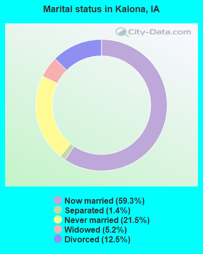
- Never married: 21.5%
- Now married: 59.3%
- Separated: 1.4%
- Widowed: 5.2%
- Divorced: 12.5%
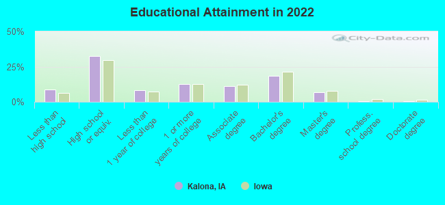
For population 25 years and over in Kalona:
- High school or higher: 89.8%
- Bachelor's degree or higher: 24.6%
- Graduate or professional degree: 7.2%
- Unemployed: 1.3%
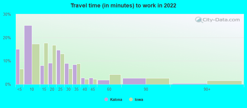
- Mean travel time to work (commute): 17.1 minutes
| Here: | 9.3 |
| Iowa average: | 10.5 |
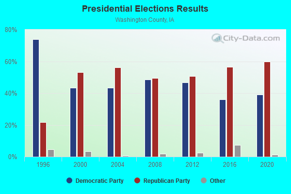
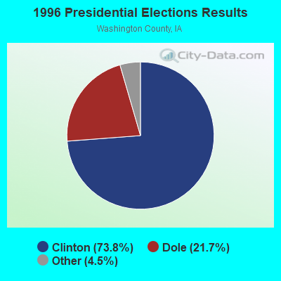
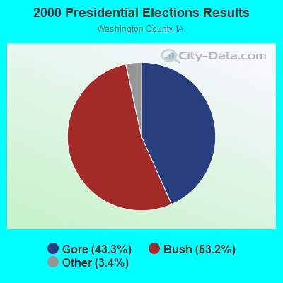

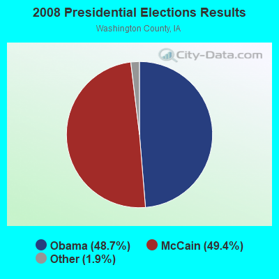


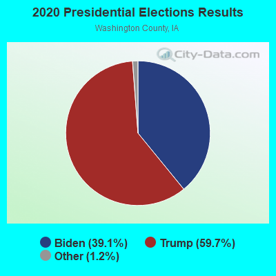
Graphs represent county-level data. Detailed 2008 Election Results
Religion statistics for Kalona, IA (based on Washington County data)
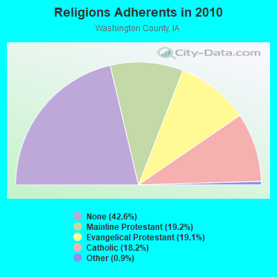
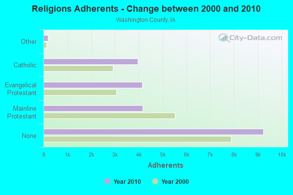
| Religion | Adherents | Congregations |
|---|---|---|
| Mainline Protestant | 4,170 | 20 |
| Evangelical Protestant | 4,150 | 30 |
| Catholic | 3,956 | 4 |
| Other | 189 | 3 |
| None | 9,239 | - |
Food Environment Statistics:
| Here: | 1.88 / 10,000 pop. |
| State: | 2.14 / 10,000 pop. |
| Washington County: | 0.94 / 10,000 pop. |
| Iowa: | 0.43 / 10,000 pop. |
| Here: | 5.65 / 10,000 pop. |
| Iowa: | 5.55 / 10,000 pop. |
| Here: | 8.48 / 10,000 pop. |
| State: | 8.01 / 10,000 pop. |
| This county: | 7.8% |
| Iowa: | 7.8% |
| This county: | 28.3% |
| Iowa: | 27.3% |
| This county: | 13.4% |
| Iowa: | 14.5% |
Health and Nutrition:
| Here: | 48.6% |
| State: | 49.5% |
| Here: | 42.9% |
| Iowa: | 46.1% |
| This city: | 28.5 |
| Iowa: | 28.6 |
| Kalona: | 19.0% |
| State: | 21.4% |
| This city: | 11.9% |
| State: | 10.4% |
| Kalona: | 6.8 |
| Iowa: | 6.8 |
| Kalona: | 35.1% |
| Iowa: | 33.8% |
| Kalona: | 53.0% |
| State: | 55.9% |
| Kalona: | 75.4% |
| Iowa: | 77.7% |
More about Health and Nutrition of Kalona, IA Residents
| Local government employment and payroll (March 2022) | |||||
| Function | Full-time employees | Monthly full-time payroll | Average yearly full-time wage | Part-time employees | Monthly part-time payroll |
|---|---|---|---|---|---|
| Local Libraries | 3 | $25,438 | $101,752 | 8 | $4,668 |
| Financial Administration | 3 | $16,326 | $65,304 | 0 | $0 |
| Streets and Highways | 2 | $18,538 | $111,228 | 0 | $0 |
| Sewerage | 1 | $4,726 | $56,712 | 0 | $0 |
| Water Supply | 1 | $4,452 | $53,424 | 0 | $0 |
| Totals for Government | 10 | $69,480 | $83,376 | 8 | $4,668 |
Kalona government finances - Expenditure in 2017 (per resident):
- Construction - Parks and Recreation: $396,000 ($146.18)
General - Other: $38,000 ($14.03)
- Current Operations - Regular Highways: $385,000 ($142.12)
General - Other: $359,000 ($132.52)
Water Utilities: $280,000 ($103.36)
Libraries: $250,000 ($92.28)
Parks and Recreation: $234,000 ($86.38)
Sewerage: $199,000 ($73.46)
Central Staff Services: $101,000 ($37.28)
Police Protection: $85,000 ($31.38)
Protective Inspection and Regulation - Other: $68,000 ($25.10)
Solid Waste Management: $59,000 ($21.78)
General Public Buildings: $50,000 ($18.46)
Local Fire Protection: $23,000 ($8.49)
Health - Other: $11,000 ($4.06)
Miscellaneous Commercial Activities - Other: $1,000 ($0.37)
Judicial and Legal Services: $1,000 ($0.37)
- General - Interest on Debt: $261,000 ($96.35)
- Total Salaries and Wages: $567,000 ($209.30)
- Water Utilities - Interest on Debt: $34,000 ($12.55)
Kalona government finances - Revenue in 2017 (per resident):
- Charges - Sewerage: $398,000 ($146.92)
Solid Waste Management: $65,000 ($23.99)
Parks and Recreation: $61,000 ($22.52)
Other: $34,000 ($12.55)
Natural Resources - Other: $26,000 ($9.60)
Miscellaneous Commercial Activities: $14,000 ($5.17)
- Local Intergovernmental - Other: $60,000 ($22.15)
- Miscellaneous - General Revenue - Other: $189,000 ($69.77)
Interest Earnings: $23,000 ($8.49)
Rents: $17,000 ($6.28)
Sale of Property: $8,000 ($2.95)
Donations From Private Sources: $6,000 ($2.21)
- Revenue - Water Utilities: $356,000 ($131.41)
- State Intergovernmental - Highways: $293,000 ($108.16)
- Tax - Property: $1,062,000 ($392.03)
General Sales and Gross Receipts: $274,000 ($101.14)
Other License: $20,000 ($7.38)
Public Utilities Sales: $14,000 ($5.17)
Kalona government finances - Debt in 2017 (per resident):
- Long Term Debt - Beginning Outstanding - Unspecified Public Purpose: $7,366,000 ($2719.08)
Outstanding Unspecified Public Purpose: $7,134,000 ($2633.44)
Retired Unspecified Public Purpose: $232,000 ($85.64)
Kalona government finances - Cash and Securities in 2017 (per resident):
- Other Funds - Cash and Securities: $7,309,000 ($2698.04)
| Businesses in Kalona, IA | ||||
| Name | Count | Name | Count | |
|---|---|---|---|---|
| Ace Hardware | 1 | RadioShack | 1 | |
| Ashley Furniture | 1 | Subway | 1 | |
| Curves | 1 | U-Haul | 1 | |
| Lane Furniture | 1 | |||
Strongest AM radio stations in Kalona:
- WSUI (910 AM; 5 kW; IOWA CITY, IA; Owner: THE UNIVERSITY OF IOWA)
- KCJJ (1630 AM; 10 kW; IOWA CITY, IA; Owner: RIVER CITY RADIO, INC.)
- KXEL (1540 AM; 50 kW; WATERLOO, IA; Owner: KXEL BROADCASTING COMPANY, INC.)
- WHO (1040 AM; 50 kW; DES MOINES, IA; Owner: CITICASTERS LICENSES, L.P.)
- WMT (600 AM; 5 kW; CEDAR RAPIDS, IA; Owner: CITICASTERS LICENSES, L.P.)
- KXIC (800 AM; 1 kW; IOWA CITY, IA; Owner: CITICASTERS LICENSES, L.P.)
- KCRG (1600 AM; 5 kW; CEDAR RAPIDS, IA; Owner: CEDAR RAPIDS TELEVISION CO.)
- KCII (1380 AM; 0 kW; WASHINGTON, IA; Owner: HOME BROADCASTING, INC.)
- WSCR (670 AM; 50 kW; CHICAGO, IL; Owner: INFINITY BROADCASTING OPERATIONS, INC.)
- WTMJ (620 AM; 50 kW; MILWAUKEE, WI; Owner: JOURNAL BROADCAST CORPORATION)
- WGN (720 AM; 50 kW; CHICAGO, IL; Owner: WGN CONTINENTAL BROADCASTING CO.)
- WBBM (780 AM; 50 kW; CHICAGO, IL; Owner: INFINITY BROADCASTING OPERATIONS, INC.)
- KPSZ (940 AM; 10 kW; DES MOINES, IA; Owner: SAGA COMMUNICATIONS OF IOWA, LLC)
Strongest FM radio stations in Kalona:
- KRNA (94.1 FM; IOWA CITY, IA; Owner: CUMULUS LICENSING CORP.)
- KSUI (91.7 FM; IOWA CITY, IA; Owner: THE UNIVERSITY OF IOWA)
- KCII-FM (106.1 FM; WASHINGTON, IA; Owner: HOME BROADCASTING, INC.)
- KKRQ (100.7 FM; IOWA CITY, IA; Owner: CITICASTERS LICENSES, L.P.)
- KBEA-FM (99.7 FM; MUSCATINE, IA; Owner: CUMULUS LICENSING CORP.)
- KUNI (90.9 FM; CEDAR FALLS, IA; Owner: UNIVERSITY OF NORTHERN IOWA)
- KDAT (104.5 FM; CEDAR RAPIDS, IA; Owner: CUMULUS LICENSING CORP.)
- KZIA (102.9 FM; CEDAR RAPIDS, IA; Owner: KZIA, INC.)
- K295AC (106.9 FM; IOWA CITY, IA; Owner: KIRKWOOD COMMUNITY COLLEGE)
TV broadcast stations around Kalona:
- KWKB (Channel 20; IOWA CITY, IA; Owner: KM TELEVISION OF IOWA, L.L.C.)
- KIIN (Channel 12; IOWA CITY, IA; Owner: IOWA PUBLIC BROADCASTING BOARD)
- KYOU-TV (Channel 15; OTTUMWA, IA; Owner: WAITT BROADCASTING, INC.)
- KFXA (Channel 28; CEDAR RAPIDS, IA; Owner: SECOND GENERATION OF IOWA, LTD.)
- KGAN (Channel 2; CEDAR RAPIDS, IA; Owner: KGAN LICENSEE, LLC)
- KCRG-TV (Channel 9; CEDAR RAPIDS, IA; Owner: CEDAR RAPIDS TELEVISION CO.)
- K64DG (Channel 64; IOWA CITY, IA; Owner: R B SHELDAHL)
- KRIN (Channel 32; WATERLOO, IA; Owner: IOWA PUBLIC BROADCASTING BOARD)
- K16EL (Channel 66; DAVENPORT, IA; Owner: THREE ANGELS BROADCASTING NETWORK)
- K13MN (Channel 13; WASHINGTON, IA; Owner: KGAN LICENSEE, LLC)
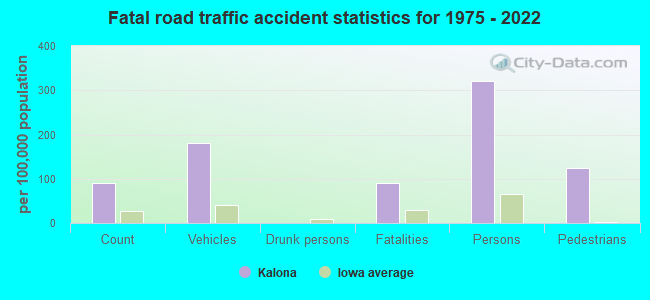
Kalona fatal accident list:
Feb 5, 1991 05:55 PM, 1, Vehicles: 2, Persons: 4, Fatalities: 1
- National Bridge Inventory (NBI) Statistics
- 28Number of bridges
- 207ft / 63.3mTotal length
- 27,793Total average daily traffic
- 2,967Total average daily truck traffic
- 27,793Total future (year 2039) average daily traffic
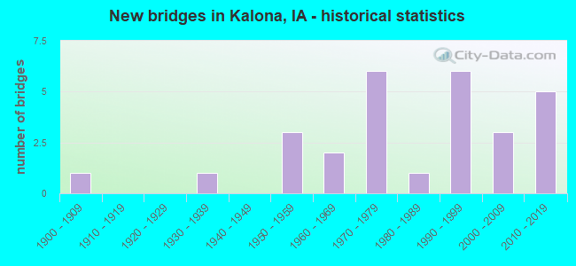
- New bridges - historical statistics
- 11900-1909
- 11930-1939
- 31950-1959
- 21960-1969
- 61970-1979
- 11980-1989
- 61990-1999
- 32000-2009
- 52010-2019
FCC Registered Antenna Towers: 39 (See the full list of FCC Registered Antenna Towers)
FCC Registered Private Land Mobile Towers: 1 (See the full list of FCC Registered Private Land Mobile Towers in Kalona, IA)
FCC Registered Broadcast Land Mobile Towers: 7 (See the full list of FCC Registered Broadcast Land Mobile Towers)
FCC Registered Microwave Towers: 10 (See the full list of FCC Registered Microwave Towers in this town)
FCC Registered Paging Towers: 1 (See the full list of FCC Registered Paging Towers)
FCC Registered Amateur Radio Licenses: 23 (See the full list of FCC Registered Amateur Radio Licenses in Kalona)
FAA Registered Aircraft Manufacturers and Dealers: 1 (See the full list of FAA Registered Manufacturers and Dealers in Kalona)
FAA Registered Aircraft: 7 (See the full list of FAA Registered Aircraft)
2002 - 2018 National Fire Incident Reporting System (NFIRS) incidents
- Fire incident types reported to NFIRS in Kalona, IA
- 22046.6%Outside Fires
- 19841.9%Structure Fires
- 459.5%Mobile Property/Vehicle Fires
- 91.9%Other
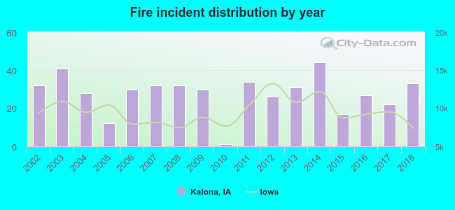 Based on the data from the years 2002 - 2018 the average number of fire incidents per year is 28. The highest number of reported fire incidents - 44 took place in 2014, and the least - 1 in 2010. The data has a rising trend.
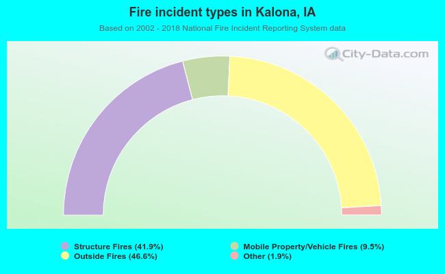 When looking into fire subcategories, the most incidents belonged to: Outside Fires (46.6%), and Structure Fires (41.9%).
| Most common first names in Kalona, IA among deceased individuals | ||
| Name | Count | Lived (average) |
|---|---|---|
| Mary | 49 | 82.2 years |
| John | 28 | 81.6 years |
| Anna | 21 | 85.6 years |
| Katie | 16 | 84.4 years |
| Emma | 14 | 88.3 years |
| Lydia | 13 | 88.5 years |
| Robert | 13 | 76.6 years |
| George | 12 | 87.0 years |
| Edna | 12 | 85.2 years |
| Raymond | 12 | 80.8 years |
| Most common last names in Kalona, IA among deceased individuals | ||
| Last name | Count | Lived (average) |
|---|---|---|
| Miller | 98 | 81.9 years |
| Yoder | 95 | 81.1 years |
| Gingerich | 52 | 82.8 years |
| Brenneman | 30 | 84.1 years |
| Swartzendrub | 30 | 83.4 years |
| Bender | 25 | 81.8 years |
| Hochstedler | 18 | 77.9 years |
| Marner | 18 | 84.0 years |
| Hershberger | 15 | 82.2 years |
| Bontrager | 15 | 78.3 years |
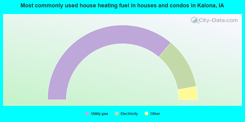
- 72.4%Utility gas
- 22.0%Electricity
- 3.6%Bottled, tank, or LP gas
- 2.1%Wood
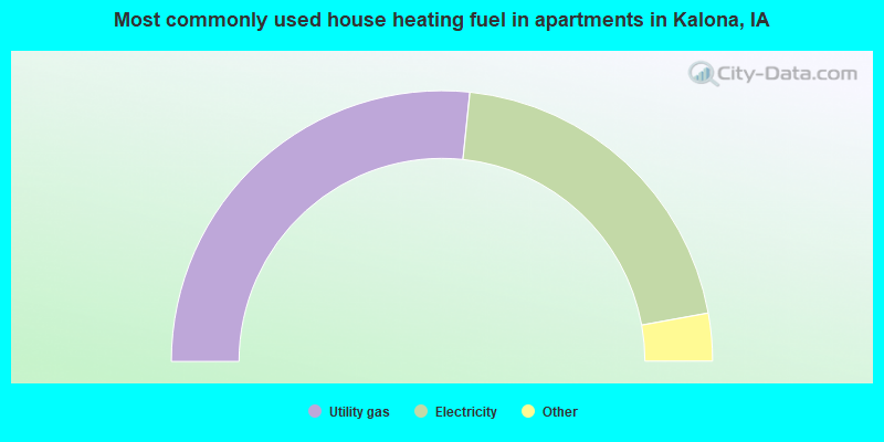
- 53.4%Utility gas
- 41.1%Electricity
- 3.4%Fuel oil, kerosene, etc.
- 2.0%Bottled, tank, or LP gas
Kalona compared to Iowa state average:
- Unemployed percentage significantly below state average.
- Black race population percentage significantly below state average.
- Hispanic race population percentage below state average.
- Number of college students below state average.

|
Total of 8 patent applications in 2008-2024.