Kensington, Georgia
Submit your own pictures of this place and show them to the world
- OSM Map
- General Map
- Google Map
- MSN Map

| Males: 1,627 | |
| Females: 1,557 |
| Median resident age: | 38.0 years |
| Georgia median age: | 33.4 years |
Zip code: 30707
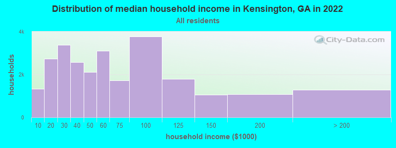
| Kensington: | $50,558 |
| GA: | $72,837 |
Estimated per capita income in 2022: $32,034 (it was $17,751 in 2000)
Kensington CCD income, earnings, and wages data
Estimated median house or condo value in 2022: $173,279 (it was $64,500 in 2000)
| Kensington: | $173,279 |
| GA: | $297,400 |
Mean prices in 2022: all housing units: $205,717; detached houses: $221,135; townhouses or other attached units: $174,404; in 2-unit structures: $100,864; in 5-or-more-unit structures: $240,901; mobile homes: $70,670
Detailed information about poverty and poor residents in Kensington, GA


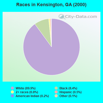
- 2,71189.9%White alone
- 2538.4%Black alone
- 230.8%Two or more races
- 150.5%Hispanic
- 60.2%American Indian alone
- 40.1%Other race alone
- 20.07%Asian alone
- 10.03%Native Hawaiian and Other
Pacific Islander alone
Races in Kensington detailed stats: ancestries, foreign born residents, place of birth
 Recent articles from our blog. Our writers, many of them Ph.D. graduates or candidates, create easy-to-read articles on a wide variety of topics.
Current Local Time: EST time zone
Land area: 128.6 square miles.
Population density: 25 people per square mile (very low).

| Kensington CCD: | 0.6% ($359) |
| Georgia: | 0.9% ($919) |
Nearest city with pop. 50,000+: Chattanooga, TN  (23.3 miles , pop. 155,554).
Nearest city with pop. 200,000+: Atlanta, GA (87.6 miles , pop. 416,474).
Nearest city with pop. 1,000,000+: Chicago, IL (507.5 miles , pop. 2,896,016).
Nearest cities:
), ), ), )Latitude: 34.72 N, Longitude: 85.40 W
Area code: 706

| Here: | 2.8% |
| Georgia: | 2.9% |
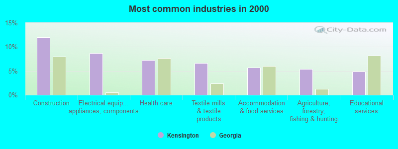
- Construction (12.0%)
- Electrical equipment, appliances, components (8.6%)
- Health care (7.3%)
- Textile mills & textile products (6.7%)
- Accommodation & food services (5.6%)
- Agriculture, forestry, fishing & hunting (5.4%)
- Educational services (4.8%)
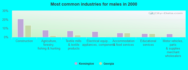
- Construction (20.6%)
- Agriculture, forestry, fishing & hunting (8.1%)
- Textile mills & textile products (7.1%)
- Electrical equipment, appliances, components (6.3%)
- Accommodation & food services (4.7%)
- Educational services (4.0%)
- Motor vehicles, parts & supplies merchant wholesalers (3.7%)
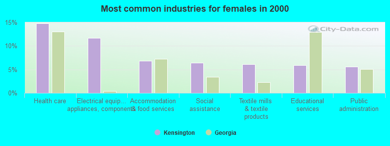
- Health care (14.8%)
- Electrical equipment, appliances, components (11.7%)
- Accommodation & food services (6.9%)
- Social assistance (6.4%)
- Textile mills & textile products (6.1%)
- Educational services (5.9%)
- Public administration (5.6%)
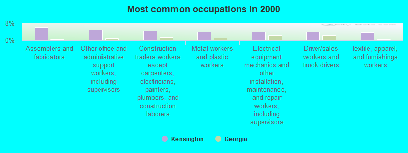
- Assemblers and fabricators (6.3%)
- Other office and administrative support workers, including supervisors (5.0%)
- Construction traders workers except carpenters, electricians, painters, plumbers, and construction laborers (4.6%)
- Metal workers and plastic workers (4.2%)
- Electrical equipment mechanics and other installation, maintenance, and repair workers, including supervisors (4.2%)
- Driver/sales workers and truck drivers (4.0%)
- Textile, apparel, and furnishings workers (3.9%)
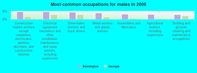
- Construction traders workers except carpenters, electricians, painters, plumbers, and construction laborers (7.5%)
- Electrical equipment mechanics and other installation, maintenance, and repair workers, including supervisors (7.5%)
- Driver/sales workers and truck drivers (7.1%)
- Metal workers and plastic workers (6.3%)
- Assemblers and fabricators (5.2%)
- Agricultural workers, including supervisors (4.9%)
- Building and grounds cleaning and maintenance occupations (4.6%)
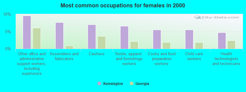
- Other office and administrative support workers, including supervisors (9.5%)
- Assemblers and fabricators (7.6%)
- Cashiers (7.0%)
- Textile, apparel, and furnishings workers (6.6%)
- Cooks and food preparation workers (5.5%)
- Child care workers (5.5%)
- Health technologists and technicians (4.7%)
Average climate in Kensington, Georgia
Based on data reported by over 4,000 weather stations


(lower is better)
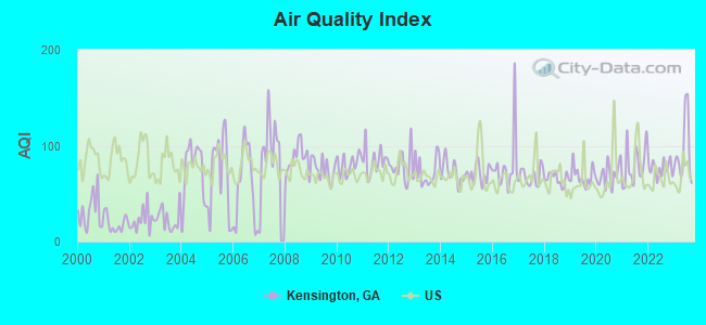
Air Quality Index (AQI) level in 2023 was 94.1. This is worse than average.
| City: | 94.1 |
| U.S.: | 72.6 |
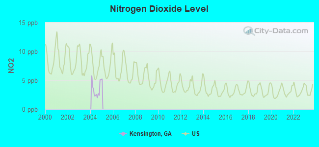
Nitrogen Dioxide (NO2) [ppb] level in 2004 was 3.44. This is significantly better than average. Closest monitor was 18.4 miles away from the city center.
| City: | 3.44 |
| U.S.: | 5.11 |

Sulfur Dioxide (SO2) [ppb] level in 2007 was 2.27. This is significantly worse than average. Closest monitor was 17.8 miles away from the city center.
| City: | 2.27 |
| U.S.: | 1.51 |
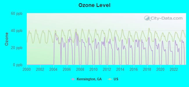
Ozone [ppb] level in 2022 was 21.5. This is significantly better than average. Closest monitor was 17.3 miles away from the city center.
| City: | 21.5 |
| U.S.: | 33.3 |
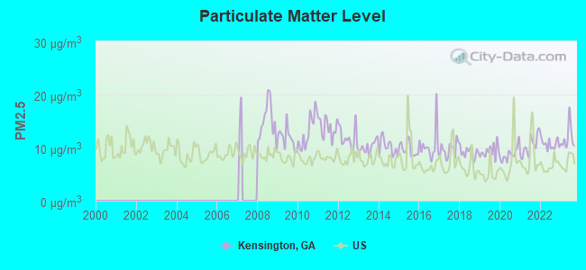
Particulate Matter (PM2.5) [µg/m3] level in 2023 was 11.8. This is significantly worse than average. Closest monitor was 18.4 miles away from the city center.
| City: | 11.8 |
| U.S.: | 8.1 |
Tornado activity:
Kensington-area historical tornado activity is slightly above Georgia state average. It is 79% greater than the overall U.S. average.
On 5/19/1973, a category F4 (max. wind speeds 207-260 mph) tornado 22.1 miles away from the Kensington place center injured 19 people and caused between $500,000 and $5,000,000 in damages.
On 4/3/1974, a category F4 tornado 25.1 miles away from the place center killed 9 people and injured 67 people and caused between $500,000 and $5,000,000 in damages.
Earthquake activity:
Kensington-area historical earthquake activity is significantly above Georgia state average. It is 113% greater than the overall U.S. average.On 4/29/2003 at 08:59:39, a magnitude 4.9 (4.4 MB, 4.6 MW, 4.9 LG, Class: Light, Intensity: IV - V) earthquake occurred 20.8 miles away from the city center
On 4/29/2003 at 08:59:39, a magnitude 4.6 (4.6 MW, Depth: 12.3 mi) earthquake occurred 20.8 miles away from the city center
On 11/30/1973 at 07:48:41, a magnitude 4.7 (4.7 MB, 4.6 ML) earthquake occurred 109.9 miles away from Kensington center
On 1/18/1999 at 07:00:53, a magnitude 4.8 (4.8 MB, 4.0 LG, Depth: 0.6 mi) earthquake occurred 140.3 miles away from the city center
On 12/12/2018 at 09:14:43, a magnitude 4.4 (4.4 MW, Depth: 4.9 mi) earthquake occurred 71.9 miles away from Kensington center
On 8/2/1974 at 08:52:09, a magnitude 4.9 (4.3 MB, 4.9 LG) earthquake occurred 176.3 miles away from Kensington center
Magnitude types: regional Lg-wave magnitude (LG), body-wave magnitude (MB), local magnitude (ML), moment magnitude (MW)
Natural disasters:
The number of natural disasters in Walker County (14) is near the US average (15).Major Disasters (Presidential) Declared: 9
Emergencies Declared: 4
Causes of natural disasters: Floods: 6, Storms: 5, Tornadoes: 5, Winter Storms: 4, Hurricanes: 2, Drought: 1, Snowfall: 1, Wind: 1, Other: 1 (Note: some incidents may be assigned to more than one category).
Hospitals and medical centers near Kensington:
- COUNTRYSIDE HOSPICE CARE (Hospital, about 6 miles away; LAFAYETTE, GA)
- HERITAGE HEALTHCARE OF LAFAYETTE (Nursing Home, about 7 miles away; LAFAYETTE, GA)
- DCI LAFAYETTE (Dialysis Facility, about 8 miles away; LA FAYETTE, GA)
- HERITAGE HEALTHCARE AT SHEPHERD HILLS (Nursing Home, about 8 miles away; LA FAYETTE, GA)
- SHEPHERD HILLS HEALTH CARE CENTER (Nursing Home, about 8 miles away; LA FAYETTE, GA)
- HARBIN CLINIC SUMMERVILLE DIALYSIS CENTER (Dialysis Facility, about 15 miles away; SUMMERVILLE, GA)
Airports located in Kensington:
- Mount Cove Airport (7GA5) (Runways: 1)
Colleges/universities with over 2000 students nearest to Kensington:
- Dalton State College (about 23 miles; Dalton, GA; Full-time enrollment: 3,846)
- The University of Tennessee-Chattanooga (about 24 miles; Chattanooga, TN; FT enrollment: 10,158)
- Chattanooga State Community College (about 28 miles; Chattanooga, TN; FT enrollment: 6,827)
- Southern Adventist University (about 30 miles; Collegedale, TN; FT enrollment: 2,898)
- Northeast Alabama Community College (about 32 miles; Rainsville, AL; FT enrollment: 2,409)
- Berry College (about 33 miles; Mount Berry, GA; FT enrollment: 2,102)
- Georgia Northwestern Technical College (about 37 miles; Rome, GA; FT enrollment: 4,629)
Points of interest:
Notable locations in Kensington: Camp Adahi (A), Mountain Cove Farms (B), Mountain View Farms (C), Valley View Ranch Camp (D), Lookout (E), Walker County Emergency Services Station 18 Dougherty Gap (F), Walker County Emergency Services Station 12 Cedar Grove (G), Walker County Emergency Services Station 9 Kensington (H). Display/hide their locations on the map
Churches in Kensington include: Lookout Baptist Church (A), Kensington United Methodist Church (B), High Church (C), Cassandra Church (D), Cassandra Baptist Church (E), Barretts Church (F), Mount Carmel Church (G), Mount Hermon Church (H), Pleasant Grove Church (I). Display/hide their locations on the map
Cemeteries: Anderson Cemetery (1), Bailey Cemetery (2), Shaw Cemetery (3), Cedar Grove Cemetery (4), Old Antioch Cemetery (5), Antioch Cemetery (6), Mount Carmel Cemetery (7). Display/hide their locations on the map
Reservoirs: Scott Lake (A), Gilbert Lake (B), Camp Adahi Lake (C), Harris Lake (D), Lloyds Lake (E), Mountain Cove Lake (F). Display/hide their locations on the map
Streams, rivers, and creeks: Milligan Branch (A), Wheeler Branch (B), Weathers Branch (C), Walden Branch (D), Voiles Creek (E), Trickum Branch (F), Strickland Branch (G), Hogjowl Creek (H), Hise Branch (I). Display/hide their locations on the map
Park in Kensington: Cloudland Canyon State Park (1). Display/hide its location on the map
Birthplace of: Whit Wyatt - Baseball player-coach.
| This place: | 2.5 people |
| Georgia: | 2.6 people |
| This place: | 73.8% |
| Whole state: | 68.5% |
| This place: | 5.5% |
| Whole state: | 5.9% |
Likely homosexual households (counted as self-reported same-sex unmarried-partner households)
- Lesbian couples: 0.5% of all households
- Gay men: 0.1% of all households
| This place: | 13.0% |
| Whole state: | 13.0% |
| This place: | 4.1% |
| Whole state: | 6.1% |
For population 15 years and over in Kensington:
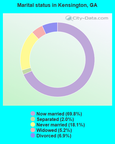
- Never married: 18.1%
- Now married: 69.8%
- Separated: 2.0%
- Widowed: 5.2%
- Divorced: 6.9%
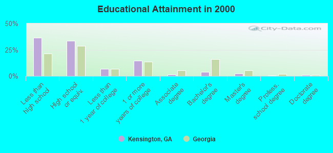
For population 25 years and over in Kensington:
- High school or higher: 63.7%
- Bachelor's degree or higher: 7.4%
- Graduate or professional degree: 3.6%
- Unemployed: 6.1%
- Mean travel time to work (commute): 35.5 minutes
| Here: | 13.2 |
| Georgia average: | 13.3 |
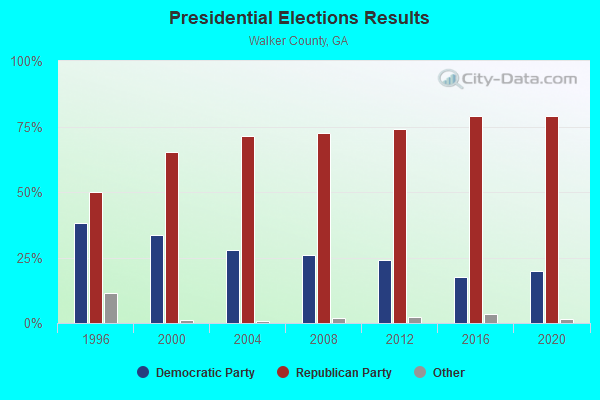
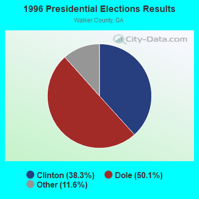
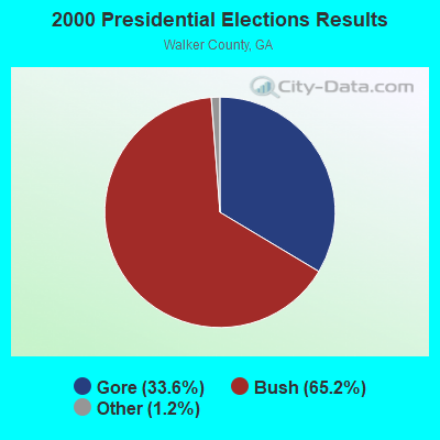
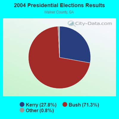
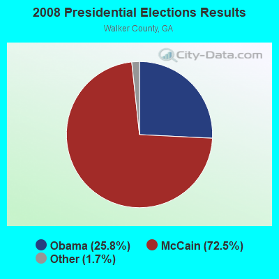
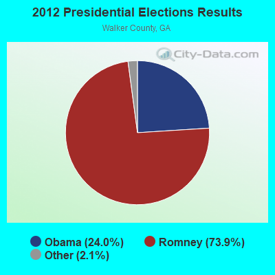
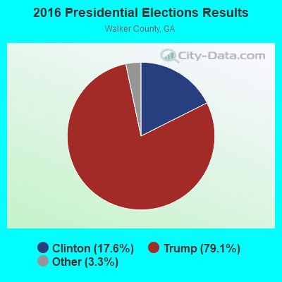
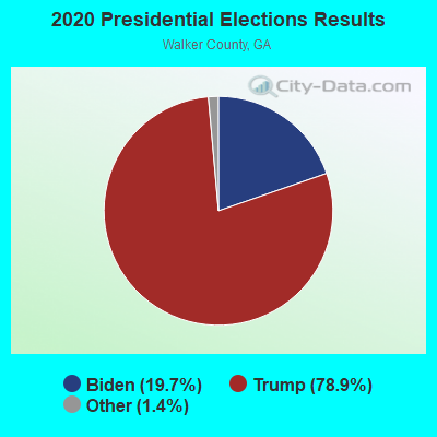
Graphs represent county-level data. Detailed 2008 Election Results
Religion statistics for Kensington, GA (based on Walker County data)
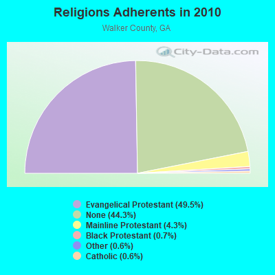
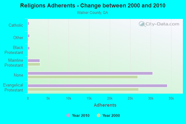
| Religion | Adherents | Congregations |
|---|---|---|
| Evangelical Protestant | 34,045 | 109 |
| Mainline Protestant | 2,948 | 16 |
| Black Protestant | 474 | 4 |
| Other | 419 | 3 |
| Catholic | 410 | 1 |
| None | 30,460 | - |
Food Environment Statistics:
| Walker County: | 1.71 / 10,000 pop. |
| State: | 1.91 / 10,000 pop. |
| This county: | 0.16 / 10,000 pop. |
| Georgia: | 0.15 / 10,000 pop. |
| Here: | 1.09 / 10,000 pop. |
| Georgia: | 0.86 / 10,000 pop. |
| This county: | 5.74 / 10,000 pop. |
| Georgia: | 5.12 / 10,000 pop. |
| Walker County: | 3.57 / 10,000 pop. |
| State: | 7.41 / 10,000 pop. |
| Walker County: | 11.7% |
| Georgia: | 10.4% |
| This county: | 28.4% |
| State: | 27.8% |
| Walker County: | 12.0% |
| State: | 14.6% |
Strongest AM radio stations in Kensington:
- WFLI (1070 AM; 50 kW; LOOKOUT MOUNTAIN, TN; Owner: WFLI, INC.)
- WWAM (820 AM; daytime; 50 kW; JASPER, TN; Owner: SHELTON BROADCASTING SYSTEM)
- WQCH (1590 AM; 5 kW; LAFAYETTE, GA; Owner: RADIX BROADCASTING, INC.)
- WQRX (870 AM; daytime; 10 kW; VALLEY HEAD, AL; Owner: BARINOWSKI INVESTMENT COMPANY)
- WTTI (1530 AM; daytime; 10 kW; DALTON, GA; Owner: PYE WILSON BROADCASTING, INC.)
- WGTA (950 AM; 5 kW; SUMMERVILLE, GA; Owner: AZTECA COMMUNICATIONS, INC.)
- WNSI (810 AM; 50 kW; JACKSONVILLE, AL; Owner: UNITED BROADCASTING NETWORK, INC.)
- WKWN (1420 AM; 2 kW; TRENTON, GA; Owner: RA-AD OF TRENTON, INC.)
- WZQZ (1180 AM; daytime; 5 kW; TRION, GA; Owner: BARINOWSKI INVESTMENT COMPANY)
- WFTD (1080 AM; daytime; 50 kW; MARIETTA, GA; Owner: PRIETO ENTERPRISES, INC.)
- WGST (640 AM; 50 kW; ATLANTA, GA; Owner: CITICASTERS LICENSES, L.P.)
- WCNN (680 AM; 50 kW; NORTH ATLANTA, GA; Owner: DICKEY BROADCASTING COMPANY)
- WKNG (1060 AM; daytime; 50 kW; TALLAPOOSA, GA; Owner: WKNG, INC.)
Strongest FM radio stations in Kensington:
- WBDX (102.7 FM; TRENTON, GA; Owner: PARTNERS FOR CHRISTIAN RADIO, INC.)
- WMBW (88.9 FM; CHATTANOOGA, TN; Owner: THE MOODY BIBLE INSTITUTE OF CHICAGO)
- W257AZ (99.3 FM; LOOKOUT MOUNTAIN, TN; Owner: CAPSTAR TX LIMITED PARTNERSHIP)
- WUSY (100.7 FM; CLEVELAND, TN; Owner: CAPSTAR TX LIMITED PARTNERSHIP)
- WAWL-FM (91.5 FM; RED BANK, TN; Owner: CHATTANOOGA STATE TECHNICAL COMMUNITY COLLEGE)
- WATG (95.7 FM; TRION, GA; Owner: TTA BROADCASTING, INC)
- WDEF-FM (92.3 FM; CHATTANOOGA, TN; Owner: JACKSON TELECASTERS, INC.)
- W234AG (94.7 FM; CHATSWORTH, GA; Owner: IMMANUEL BROADCASTING NETWORK, INC.)
- W284AE (104.7 FM; ORCHARD HILLS, GA; Owner: WAY-FM MEDIA GROUP, INC.)
- WDOD-FM (96.5 FM; CHATTANOOGA, TN; Owner: WDOD OF CHATTANOOGA, INC.)
- WSKZ (106.5 FM; CHATTANOOGA, TN; Owner: CITADEL BROADCASTING COMPANY)
- WLOV-FM1 (97.3 FM; CHATTANOOGA, TN; Owner: CAPSTAR TX LIMITED PARTNERSHIP)
- WKXJ (98.1 FM; SIGNAL MOUNTAIN, TN; Owner: CAPSTAR TX LIMITED PARTNERSHIP)
- WMXF-FM (97.3 FM; SOUTH PITTSBURG, TN; Owner: CAPSTAR TX LIMITED PARTNERSHIP)
- WRXR-FM (105.5 FM; ROSSVILLE, GA; Owner: CAPSTAR TX LIMITED PARTNERSHIP)
- WOGT (107.9 FM; EAST RIDGE, TN; Owner: CITADEL BROADCASTING COMPANY)
- WSGC-FM (101.9 FM; RINGGOLD, GA; Owner: CLEAR CHANNEL BROADCASTING LICENSES, INC.)
- W241AF (96.1 FM; ROSSVILLE, GA; Owner: IMMANUEL BROADCASTING NETWORK, INC.)
- WMXN-FM (101.7 FM; STEVENSON, AL; Owner: KEA RADIO, INC.)
- W278AC (103.5 FM; WALDEN, TN; Owner: CAPSTAR TX LIMITED PARTNERSHIP)
TV broadcast stations around Kensington:
- WFLI-TV (Channel 53; CLEVELAND, TN; Owner: CHATTANOOGA MEDIA HOLDINGS, L.L.C.)
- WELF (Channel 23; DALTON, GA; Owner: TRINITY BROADCASTING NETWORK)
- W64BJ (Channel 64; SCOTTSBORO, AL; Owner: TRINITY BROADCASTING NETWORK)
- WLFW-LP (Channel 41; LAFAYETTE, GA; Owner: NORTH GEORGIA TELEVISION)
- WDEF-TV (Channel 12; CHATTANOOGA, TN; Owner: MEDIA GENERAL COMMUNICATIONS, INC.)
- WSUT-LP (Channel 21; SUMMERVILLE/TRION, GA; Owner: NORTH GEORGIA TELEVISION/NGTV)
- W35AA (Channel 35; La FAYETTE, GA; Owner: GEORGIA PUBLIC TELECOMMUNICATIONS COMMISSION)
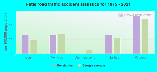
Kensington fatal accident list:
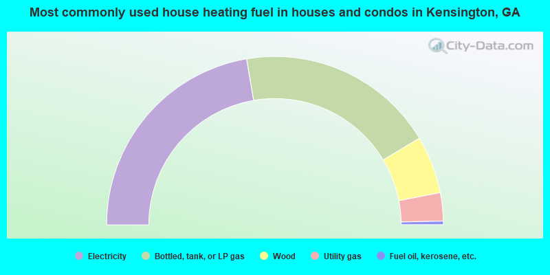
- 44.6%Electricity
- 38.2%Bottled, tank, or LP gas
- 11.1%Wood
- 5.4%Utility gas
- 0.7%Fuel oil, kerosene, etc.
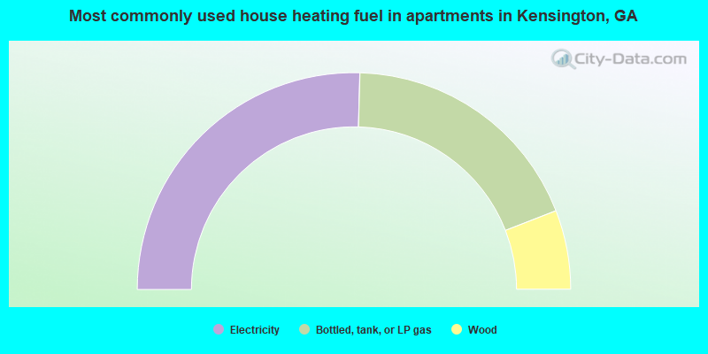
- 50.9%Electricity
- 37.3%Bottled, tank, or LP gas
- 11.8%Wood
Kensington compared to Georgia state average:
- Median house value below state average.
- Unemployed percentage below state average.
- Black race population percentage significantly below state average.
- Hispanic race population percentage significantly below state average.
- Foreign-born population percentage significantly below state average.
- Renting percentage below state average.
- Length of stay since moving in significantly above state average.
- Number of rooms per house significantly below state average.
- House age significantly below state average.
- Percentage of population with a bachelor's degree or higher significantly below state average.