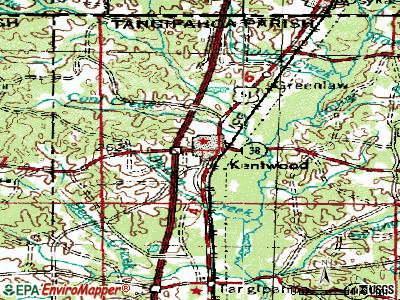
Kentwood, Louisiana
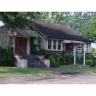
Kentwood: Kentwood Hiatorical and Cultural Museum and Office of the Clerk of court
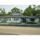
Kentwood: Kentwood Manor, The place I will always remember as the place where my father spent his last days on earth.
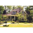
Kentwood: beautiful house in Kentwood

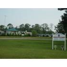
Kentwood: Paris Flea Market
Kentwood: Paris Flea Market
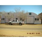
Kentwood: This is one of the oldest business in Kentwood, It was once "Collet's Flowers", it is now called "Glenda's, Glenda told me that after all these years it is still it is still a Collet family business.
- add
your
Submit your own pictures of this town and show them to the world
- OSM Map
- General Map
- Google Map
- MSN Map
Population change since 2000: -1.3%
 |
| Males: 1,114 | |
| Females: 1,062 |
| Median resident age: | 36.9 years |
| Louisiana median age: | 38.2 years |
Zip codes: 70444.
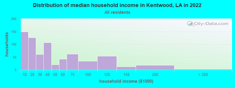
| Kentwood: | $29,919 |
| LA: | $55,416 |
Estimated per capita income in 2022: $20,101 (it was $11,171 in 2000)
Kentwood town income, earnings, and wages data
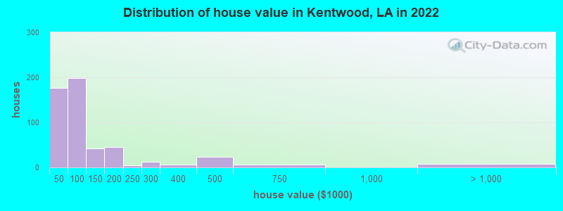
Estimated median house or condo value in 2022: $82,420 (it was $47,200 in 2000)
| Kentwood: | $82,420 |
| LA: | $209,200 |
Mean prices in 2022: all housing units: $150,329; detached houses: $203,545; mobile homes: $44,319
Median gross rent in 2022: $797.
(31.9% for White Non-Hispanic residents, 26.2% for Black residents, 12.1% for Hispanic or Latino residents, 29.4% for two or more races residents)
Detailed information about poverty and poor residents in Kentwood, LA


Compare current foreclosures near Kentwood, LA:
| Photo | Address | Area | Beds / Baths | Price | Details |
|---|---|---|---|---|---|

|
#1
St
Kentwood, LA 70444
|
- sq. feet
|
- baths - beds |
$6,000
|
show details |

|
#2
Ave B
Kentwood, LA 70444
|
- sq. feet
|
- baths - beds |
$6,000
|
show details |

|
#3
B Temple Rd
Kentwood, LA Array
|
- sq. feet
|
- baths - beds |
$5,095
|
show details |

|
#4
Orange St
Kentwood, LA 70444
|
- sq. feet
|
- baths - beds |
$6,000
|
show details |

|
#5
Miller Rd
Kentwood, LA 70444
|
- sq. feet
|
- baths - beds |
$6,000
|
show details |

|
#6
St
Kentwood, LA 70444
|
- sq. feet
|
- baths - beds |
$6,000
|
show details |

|
#7
St
Kentwood, LA 70444
|
- sq. feet
|
- baths - beds |
$6,000
|
show details |

|
#8
Eleventh St
Kentwood, LA 70444
|
- sq. feet
|
- baths - beds |
$6,000
|
show details |

|
#9
Strickland Ln
Kentwood, LA 70444
|
- sq. feet
|
- baths - beds |
show details | |

|
#10
Highway 1054
Kentwood, LA 70444
|
- sq. feet
|
- baths - beds |
show details |
| Photo | Address | Area | Beds / Baths | Price | Details |
|---|---|---|---|---|---|

|
#11
Monroe Stevens Rd
Kentwood, LA 70444
|
- sq. feet
|
- baths - beds |
show details | |

|
#12
Merle Dyson Rd
Kentwood, LA 70444
|
- sq. feet
|
- baths - beds |
show details | |

|
#13
Hookfin Rd
Kentwood, LA 70444
|
- sq. feet
|
- baths - beds |
show details | |

|
#14
M C Carter Rd
Kentwood, LA 70444
|
- sq. feet
|
- baths - beds |
show details | |

|
#15
M L Varnado Rd
Kentwood, LA 70444
|
- sq. feet
|
- baths - beds |
show details | |

|
#16
Oak Hill Rd
Kentwood, LA 70444
|
- sq. feet
|
- baths - beds |
show details | |

|
#17
Jackson Rd
Kentwood, LA 70444
|
- sq. feet
|
- baths - beds |
show details | |

|
#18
Oak Ridge Church Rd
Kentwood, LA 70444
|
- sq. feet
|
- baths - beds |
show details | |

|
#19
Hunt Rd
Kentwood, LA 70444
|
- sq. feet
|
- baths - beds |
show details | |

|
#20
J R Ln
Kentwood, LA 70444
|
- sq. feet
|
- baths - beds |
show details |
| Photo | Address | Area | Beds / Baths | Price | Details |
|---|---|---|---|---|---|

|
#21
M Williams Rd
Kentwood, LA 70444
|
- sq. feet
|
- baths - beds |
show details | |

|
#22
Avenue D
Kentwood, LA 70444
|
- sq. feet
|
- baths - beds |
show details | |

|
#23
Highway 38
Kentwood, LA 70444
|
- sq. feet
|
- baths - beds |
show details | |

|
#24
Newman Rd
Kentwood, LA 70444
|
- sq. feet
|
- baths - beds |
show details | |

|
#25
Avenue J
Kentwood, LA 70444
|
- sq. feet
|
- baths - beds |
show details | |

|
#26
Simmons Rd
Kentwood, LA 70444
|
- sq. feet
|
- baths - beds |
show details | |

|
#27
Rd
Roseland, LA 70456
|
- sq. feet
|
- baths - beds |
$6,000
|
show details |

|
#28
E Pine St
Amite, LA 70422
|
3,552 sq. feet
|
4 baths 4 beds |
show details | |

|
#29
Ave
Roseland, LA 70456
|
- sq. feet
|
- baths - beds |
$6,000
|
show details |

|
#30
Town Rd
Roseland, LA 70456
|
- sq. feet
|
- baths - beds |
$6,000
|
show details |
| Photo | Address | Area | Beds / Baths | Price | Details |
|---|---|---|---|---|---|

|
#31
Rd
Amite, LA 70422
|
- sq. feet
|
- baths - beds |
$6,000
|
show details |

|
#32
W Martin Luther King St
Amite, LA 70422
|
- sq. feet
|
- baths - beds |
$6,000
|
show details |

|
#33
Olive St
Amite, LA 70422
|
- sq. feet
|
- baths - beds |
$6,000
|
show details |

|
#34
Rd
Fluker, LA 70436
|
- sq. feet
|
- baths - beds |
$6,000
|
show details |

|
#35
St
Tangipahoa, LA 70465
|
- sq. feet
|
- baths - beds |
$6,000
|
show details |

|
#36
Ave B
Tangipahoa, LA 70465
|
- sq. feet
|
- baths - beds |
$6,000
|
show details |

|
#37
St
Tangipahoa, LA 70465
|
- sq. feet
|
- baths - beds |
$6,000
|
show details |

|
#38
W Martin Luther King St
Amite, LA 70422
|
- sq. feet
|
- baths - beds |
$6,000
|
show details |

|
#39
E Chestnut St
Amite, LA 70422
|
- sq. feet
|
- baths - beds |
$6,000
|
show details |

|
#40
Paul Honea Rd
Magnolia, MS 39652
|
1,495 sq. feet
|
1 baths - beds |
show details |
| Photo | Address | Area | Beds / Baths | Price | Details |
|---|---|---|---|---|---|

|
#41
Allen Ln
Magnolia, MS 39652
|
- sq. feet
|
- baths - beds |
show details | |

|
#42
Wilson Dr
Magnolia, MS 39652
|
- sq. feet
|
- baths - beds |
show details | |

|
#43
E Olive St
Amite, LA 70422
|
- sq. feet
|
- baths - beds |
show details | |

|
#44
W End Dr Apt B12
Magnolia, MS 39652
|
- sq. feet
|
- baths - beds |
show details | |

|
#45
Kelsey Dr
Amite, LA 70422
|
- sq. feet
|
- baths - beds |
show details | |

|
#46
Highway 16 Lot 18
Amite, LA 70422
|
- sq. feet
|
- baths - beds |
show details | |

|
#47
Wayne Stevens Rd
Amite, LA 70422
|
- sq. feet
|
- baths - beds |
show details | |

|
#48
Sycamore St
Amite, LA 70422
|
- sq. feet
|
- baths - beds |
show details | |

|
#49
Division St
Amite, LA 70422
|
- sq. feet
|
- baths - beds |
show details | |

|
Check over 1 million property listings on Foreclosure.com!
|
browse all offers | |||


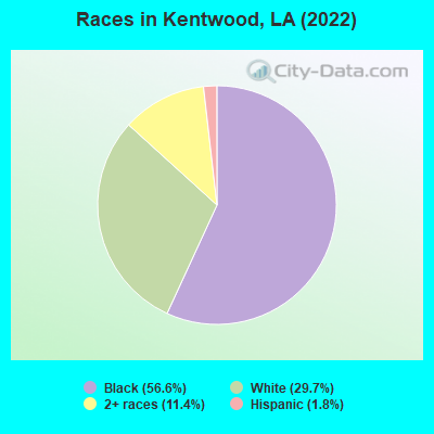
- 1,11856.6%Black alone
- 58729.7%White alone
- 22511.4%Two or more races
- 361.8%Hispanic
Races in Kentwood detailed stats: ancestries, foreign born residents, place of birth
According to our research of Louisiana and other state lists, there were 29 registered sex offenders living in Kentwood, Louisiana as of May 14, 2024.
The ratio of all residents to sex offenders in Kentwood is 83 to 1.
Type |
2009 |
2010 |
2011 |
2012 |
2013 |
2014 |
2015 |
2016 |
2017 |
2018 |
|---|---|---|---|---|---|---|---|---|---|---|
| Murders (per 100,000) | 0 (0.0) | 1 (45.5) | 0 (0.0) | 0 (0.0) | 0 (0.0) | 0 (0.0) | 0 (0.0) | 0 (0.0) | 1 (41.5) | 0 (0.0) |
| Rapes (per 100,000) | 1 (43.8) | 0 (0.0) | 1 (45.1) | 1 (44.7) | 2 (88.8) | 0 (0.0) | 4 (171.2) | 3 (126.7) | 2 (83.1) | 1 (41.1) |
| Robberies (per 100,000) | 4 (175.2) | 5 (227.5) | 7 (315.6) | 3 (134.0) | 4 (177.6) | 6 (261.4) | 11 (470.7) | 2 (84.5) | 8 (332.4) | 0 (0.0) |
| Assaults (per 100,000) | 22 (963.6) | 16 (727.9) | 11 (495.9) | 3 (134.0) | 23 (1,021) | 12 (522.9) | 29 (1,241) | 18 (760.1) | 15 (623.2) | 17 (698.4) |
| Burglaries (per 100,000) | 26 (1,139) | 78 (3,549) | 40 (1,803) | 36 (1,609) | 136 (6,039) | 44 (1,917) | 61 (2,610) | 44 (1,858) | 65 (2,700) | 25 (1,027) |
| Thefts (per 100,000) | 128 (5,607) | 128 (5,823) | 101 (4,554) | 115 (5,139) | 79 (3,508) | 115 (5,011) | 194 (8,301) | 121 (5,110) | 103 (4,279) | 82 (3,369) |
| Auto thefts (per 100,000) | 9 (394.2) | 3 (136.5) | 1 (45.1) | 3 (134.0) | 9 (399.6) | 3 (130.7) | 16 (684.6) | 5 (211.1) | 9 (373.9) | 2 (82.2) |
| Arson (per 100,000) | 0 (0.0) | 0 (0.0) | 0 (0.0) | 0 (0.0) | 0 (0.0) | 0 (0.0) | 0 (0.0) | 0 (0.0) | 0 (0.0) | 0 (0.0) |
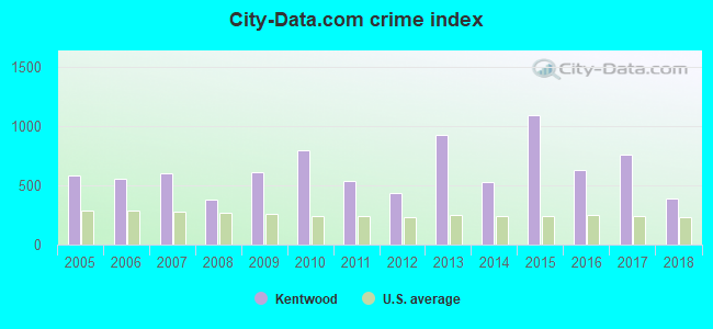
| City-Data.com crime index | 615.9 | 797.1 | 541.9 | 431.6 | 923.6 | 528.1 | 1095.8 | 630.1 | 764.0 | 385.8 |
The City-Data.com crime index weighs serious crimes and violent crimes more heavily. Higher means more crime, U.S. average is 246.1. It adjusts for the number of visitors and daily workers commuting into cities.
Crime rate in Kentwood detailed stats: murders, rapes, robberies, assaults, burglaries, thefts, arson
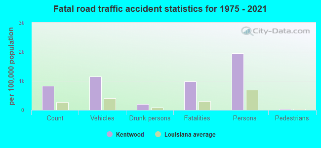
Full-time law enforcement employees in 2018, including police officers: 11 (10 officers - 7 male; 3 female).
| Officers per 1,000 residents here: | 4.11 |
| Louisiana average: | 3.31 |
 Recent articles from our blog. Our writers, many of them Ph.D. graduates or candidates, create easy-to-read articles on a wide variety of topics.

 | Is the Superdome the Most Significant Spots Venue in America? (16 replies) |
| Which town would you pick? (10 replies) |
| Getting a Job in New Orleans? (34 replies) |
| Baton Rouge Water (33 replies) |
| Recreation/Outdoors in or near New Orleans. (5 replies) |
| Tap water in NOLA (14 replies) |
Latest news from Kentwood, LA collected exclusively by city-data.com from local newspapers, TV, and radio stations
Ancestries: American (11.8%), English (5.0%), Irish (1.6%), Scottish (1.1%).
Current Local Time: CST time zone
Elevation: 225 feet
Land area: 6.92 square miles.
Population density: 314 people per square mile (very low).
10 residents are foreign born
| This town: | 0.5% |
| Louisiana: | 4.2% |
Median real estate property taxes paid for housing units with mortgages in 2022: $183 (0.2%)
Median real estate property taxes paid for housing units with no mortgage in 2022: $179 (0.3%)
Nearest city with pop. 50,000+: Baton Rouge, LA  (49.7 miles , pop. 227,818).
Nearest city with pop. 1,000,000+: Houston, TX (301.6 miles , pop. 1,953,631).
Nearest cities:
), ), )Latitude: 30.94 N, Longitude: 90.52 W
Area code: 985

Kentwood, Louisiana accommodation & food services - Economy and Business Data
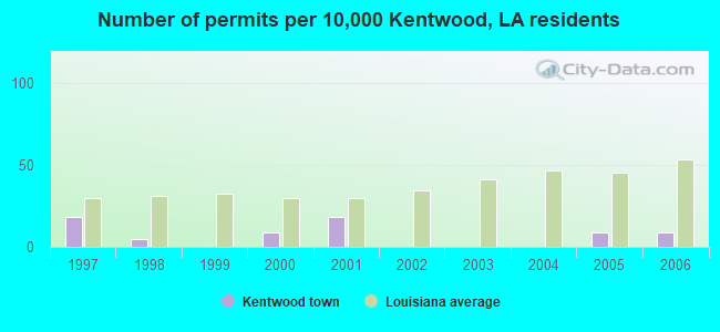
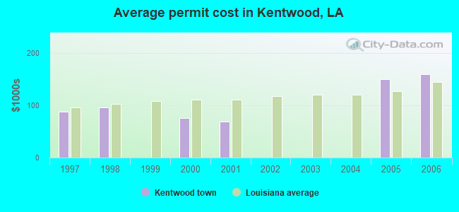
Single-family new house construction building permits:
- 2006: 2 buildings, average cost: $159,000
- 2005: 2 buildings, average cost: $148,500
- 2001: 4 buildings, average cost: $69,100
- 2000: 2 buildings, average cost: $75,000
- 1998: 1 building, cost: $95,700
- 1997: 4 buildings, average cost: $87,200
| Here: | 4.4% |
| Louisiana: | 3.8% |
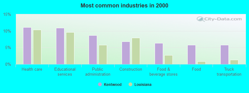
- Health care (11.0%)
- Educational services (10.9%)
- Public administration (8.7%)
- Construction (6.8%)
- Food & beverage stores (6.3%)
- Food (5.7%)
- Truck transportation (5.7%)
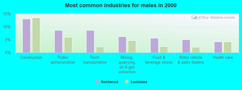
- Construction (13.0%)
- Public administration (8.6%)
- Truck transportation (8.6%)
- Mining, quarrying, oil & gas extraction (6.2%)
- Food & beverage stores (5.6%)
- Motor vehicle & parts dealers (5.0%)
- Health care (4.1%)
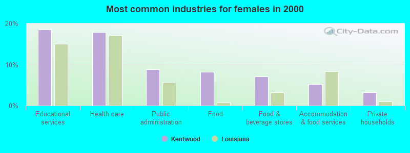
- Educational services (18.5%)
- Health care (17.9%)
- Public administration (8.8%)
- Food (8.2%)
- Food & beverage stores (7.0%)
- Accommodation & food services (5.3%)
- Private households (3.2%)
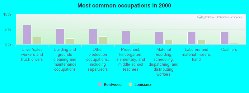
- Driver/sales workers and truck drivers (6.5%)
- Building and grounds cleaning and maintenance occupations (5.3%)
- Other production occupations, including supervisors (5.2%)
- Preschool, kindergarten, elementary, and middle school teachers (4.6%)
- Material recording, scheduling, dispatching, and distributing workers (4.3%)
- Laborers and material movers, hand (4.1%)
- Cashiers (4.1%)
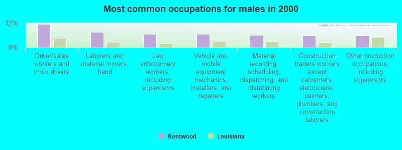
- Driver/sales workers and truck drivers (11.5%)
- Laborers and material movers, hand (7.7%)
- Law enforcement workers, including supervisors (6.5%)
- Vehicle and mobile equipment mechanics, installers, and repairers (6.5%)
- Material recording, scheduling, dispatching, and distributing workers (6.2%)
- Construction traders workers except carpenters, electricians, painters, plumbers, and construction laborers (5.9%)
- Other production occupations, including supervisors (5.9%)
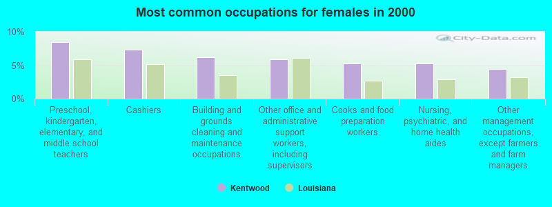
- Preschool, kindergarten, elementary, and middle school teachers (8.5%)
- Cashiers (7.3%)
- Building and grounds cleaning and maintenance occupations (6.2%)
- Other office and administrative support workers, including supervisors (5.9%)
- Cooks and food preparation workers (5.3%)
- Nursing, psychiatric, and home health aides (5.3%)
- Other management occupations, except farmers and farm managers (4.4%)
Average climate in Kentwood, Louisiana
Based on data reported by over 4,000 weather stations


|
|

Tornado activity:
Kentwood-area historical tornado activity is slightly above Louisiana state average. It is 94% greater than the overall U.S. average.
On 1/10/1975, a category F4 (max. wind speeds 207-260 mph) tornado 16.9 miles away from the Kentwood town center killed 9 people and injured 210 people and caused between $5,000,000 and $50,000,000 in damages.
On 12/13/1977, a category F3 (max. wind speeds 158-206 mph) tornado 11.2 miles away from the town center injured 2 people and caused between $5000 and $50,000 in damages.
Earthquake activity:
Kentwood-area historical earthquake activity is significantly above Louisiana state average. It is 127% greater than the overall U.S. average.On 10/24/1997 at 08:35:17, a magnitude 4.9 (4.8 MB, 4.2 MS, 4.9 LG, Depth: 6.2 mi, Class: Light, Intensity: IV - V) earthquake occurred 192.7 miles away from Kentwood center
On 5/17/2012 at 08:12:00, a magnitude 4.8 (4.8 MW, Depth: 3.1 mi) earthquake occurred 237.5 miles away from the city center
On 1/18/1999 at 07:00:53, a magnitude 4.8 (4.8 MB, 4.0 LG, Depth: 0.6 mi) earthquake occurred 256.1 miles away from Kentwood center
On 5/6/2018 at 16:47:09, a magnitude 4.6 (4.6 MB, Depth: 6.2 mi) earthquake occurred 239.2 miles away from Kentwood center
On 11/7/2004 at 11:20:21, a magnitude 4.3 (4.3 MW, Depth: 3.1 mi) earthquake occurred 192.6 miles away from Kentwood center
On 3/25/1976 at 00:41:20, a magnitude 5.0 (4.9 MB, 5.0 LG, Class: Moderate, Intensity: VI - VII) earthquake occurred 325.3 miles away from Kentwood center
Magnitude types: regional Lg-wave magnitude (LG), body-wave magnitude (MB), surface-wave magnitude (MS), moment magnitude (MW)
Natural disasters:
The number of natural disasters in Tangipahoa Parish (29) is a lot greater than the US average (15).Major Disasters (Presidential) Declared: 21
Emergencies Declared: 5
Causes of natural disasters: Hurricanes: 15, Storms: 8, Floods: 7, Tropical Storms: 4, Drought: 1, Freeze: 1, Tornado: 1, Other: 2 (Note: some incidents may be assigned to more than one category).
Hospitals and medical centers in Kentwood:
Airports located in Kentwood:
- Cool Creek Airport (76LS) (Runways: 1)
- Spring Airport (86LA) (Runways: 1)
Colleges/universities with over 2000 students nearest to Kentwood:
- Southeastern Louisiana University (about 30 miles; Hammond, LA; Full-time enrollment: 12,713)
- Louisiana State University and Agricultural & Mechanical College (about 49 miles; Baton Rouge, LA; FT enrollment: 27,321)
- Southern University and A & M College (about 50 miles; Baton Rouge, LA; FT enrollment: 5,837)
- Baton Rouge Community College (about 51 miles; Baton Rouge, LA; FT enrollment: 5,744)
- Copiah-Lincoln Community College (about 53 miles; Wesson, MS; FT enrollment: 2,532)
- Pearl River Community College (about 58 miles; Poplarville, MS; FT enrollment: 3,074)
- University of New Orleans (about 69 miles; New Orleans, LA; FT enrollment: 8,201)
Public high schools in Kentwood:
- JEWEL M. SUMNER HIGH SCHOOL (Students: 512, Location: 15841 HIGHWAY 440, Grades: 8-12)
- KENTWOOD HIGH MAGNET SCHOOL (Students: 301, Location: 603 9TH STREET, Grades: 7-12)
Public elementary/middle schools in Kentwood:
- O.W. DILLON MEMORIAL ELEMENTARY SCHOOL (Students: 446, Location: 1541 C.B. TEMPLE RD, Grades: PK-6)
- CHESBROUGH ELEMENTARY SCHOOL (Students: 422, Location: 68495 HIGHWAY 1054, Grades: PK-5)
- SPRING CREEK ELEMENTARY SCHOOL (Students: 406, Location: 72961 HIGHWAY 1061, Grades: PK-5)
- JEWEL M. SUMNER MIDDLE SCHOOL (Students: 400, Location: 15649 HIGHWAY 440, Grades: 6-8)
Points of interest:
Notable locations in Kentwood: Kentwood Wastewater Treatment Facility (A), Kentwood City Hall (B), Tangipahoa Parish Police Jury (C), Kentwood Historical and Cultural Arts Museum (D), Tangipahoa Parish Sheriff's Office (E), Kentwood Police Department (F), Tangipahoa Parish Library Kentwood Branch (G), Kentwood Manor Nursing Home (H), Kentwood Volunteer Fire Department (I). Display/hide their locations on the map
Churches in Kentwood include: Kentwood United Pentecostal Church (A), Kentwood United Methodist Church (B), Kentwood Assembly of God Church (C), First Baptist Church (D), Sweet Home Church (E), The Lighthouse Church (F), Temple Chapel Baptist Church (G), Sweet Home Baptist Church (H), Shiloh Baptist Church (I). Display/hide their locations on the map
Cemetery: Woodland Cemetery (1). Display/hide its location on the map
Streams, rivers, and creeks: Cool Creek (A), Ashleys Branch (B). Display/hide their locations on the map
Tourist attraction: Camp Moore (Museums; 70640 Camp Moore Road).
Birthplace of: William M. Rainach - Politician, Clay Shaw - Businessman, Carlese Franklin - Football player, Raymond Walls - 2005 NFL player (Arizona Cardinals, born: Jul 24, 1979), William Hodding Carter, I - Farmer, Glenn Ezell - Baseball player, Johnny Thomas (wide receiver) - Football player.
Drinking water stations with addresses in Kentwood and their reported violations in the past:
SKINNYS RESTAURANT (Address: 78136 HIGHWAY 51 , Population served: 200, Groundwater):Past monitoring violations:
- One routine major monitoring violation
- One regular monitoring violation
| This town: | 2.6 people |
| Louisiana: | 2.5 people |
| This town: | 65.3% |
| Whole state: | 67.1% |
| This town: | 7.0% |
| Whole state: | 6.8% |
Likely homosexual households (counted as self-reported same-sex unmarried-partner households)
- Lesbian couples: 0.4% of all households
- Gay men: 0.0% of all households
Banks with branches in Kentwood (2011 data):
- First Guaranty Bank: Kentwood Branch at 723 Ave G, branch established on 1999/02/01; Kentwood Branch at 301 Avenue F, branch established on 1941/11/15. Info updated 2011/07/11: Bank assets: $1,353.3 mil, Deposits: $1,208.9 mil, headquarters in Hammond, LA, positive income, Commercial Lending Specialization, 20 total offices, Holding Company: First Guaranty Bancshares, Inc.
- First NBC Bank: Kentwood Branch at Avenue G And North Ninth Street, branch established on 1976/03/08. Info updated 2011/11/21: Bank assets: $2,218.7 mil, Deposits: $1,904.1 mil, headquarters in New Orleans, LA, positive income, Commercial Lending Specialization, 33 total offices, Holding Company: First Nbc Bank Holding Company
For population 15 years and over in Kentwood:

- Never married: 45.7%
- Now married: 27.7%
- Separated: 9.8%
- Widowed: 12.1%
- Divorced: 4.7%
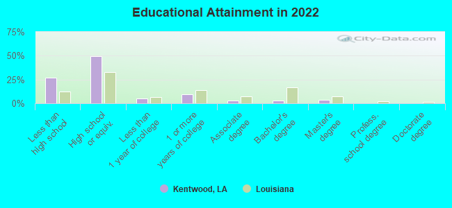
For population 25 years and over in Kentwood:
- High school or higher: 72.5%
- Bachelor's degree or higher: 8.6%
- Graduate or professional degree: 5.3%
- Unemployed: 10.9%
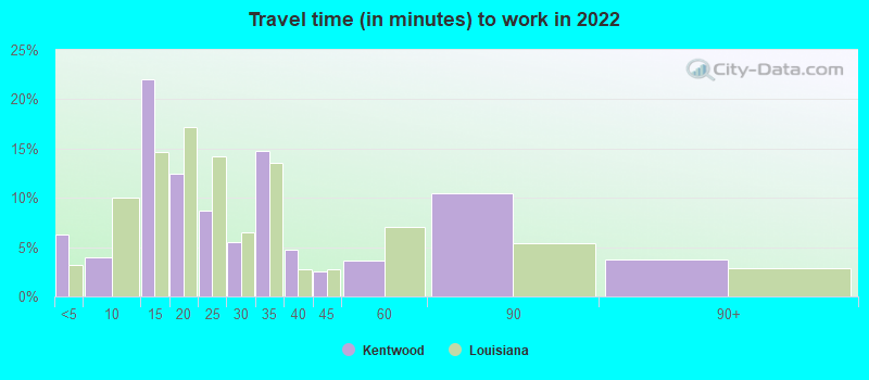
- Mean travel time to work (commute): 32.3 minutes
| Here: | 11.1 |
| Louisiana average: | 11.9 |
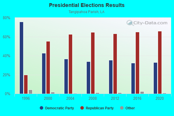
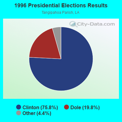
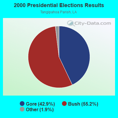
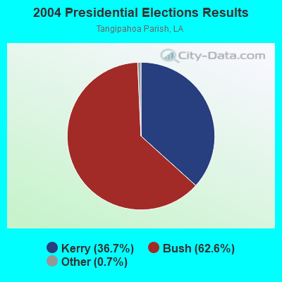


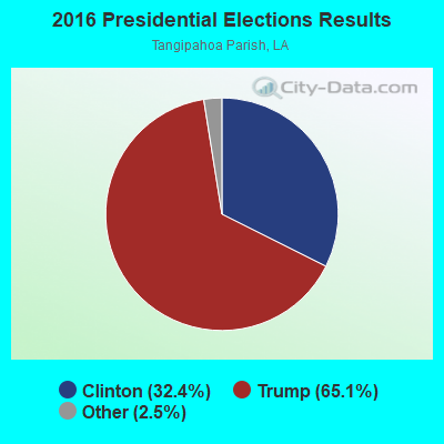
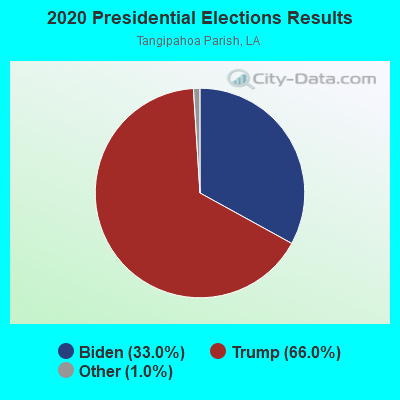
Graphs represent county-level data. Detailed 2008 Election Results
Religion statistics for Kentwood, LA (based on Tangipahoa Parish data)
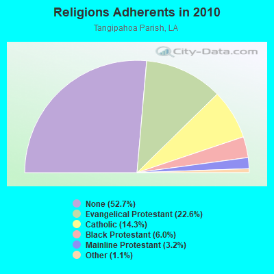
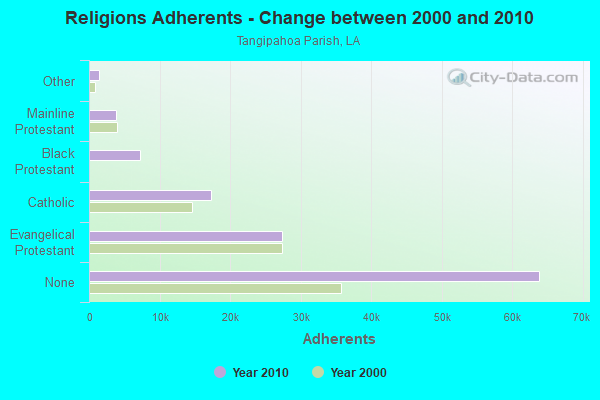
| Religion | Adherents | Congregations |
|---|---|---|
| Evangelical Protestant | 27,410 | 110 |
| Catholic | 17,327 | 6 |
| Black Protestant | 7,281 | 44 |
| Mainline Protestant | 3,867 | 18 |
| Other | 1,364 | 7 |
| None | 63,848 | - |
Food Environment Statistics:
| This county: | 2.17 / 10,000 pop. |
| Louisiana: | 2.56 / 10,000 pop. |
| Here: | 0.09 / 10,000 pop. |
| Louisiana: | 0.18 / 10,000 pop. |
| Tangipahoa Parish: | 1.30 / 10,000 pop. |
| Louisiana: | 1.29 / 10,000 pop. |
| This county: | 6.15 / 10,000 pop. |
| Louisiana: | 4.49 / 10,000 pop. |
| This county: | 6.76 / 10,000 pop. |
| Louisiana: | 5.92 / 10,000 pop. |
| This county: | 11.0% |
| State: | 10.9% |
| Tangipahoa Parish: | 32.2% |
| Louisiana: | 29.2% |
| Here: | 10.4% |
| Louisiana: | 13.7% |
Health and Nutrition:
| This city: | 46.1% |
| Louisiana: | 49.4% |
| Kentwood: | 41.9% |
| Louisiana: | 46.5% |
| Here: | 30.1 |
| Louisiana: | 29.1 |
| Kentwood: | 22.3% |
| State: | 20.3% |
| Kentwood: | 15.9% |
| State: | 11.4% |
| Kentwood: | 6.8 |
| State: | 6.8 |
| Here: | 36.4% |
| Louisiana: | 34.5% |
| Here: | 49.9% |
| State: | 55.8% |
| Kentwood: | 81.5% |
| Louisiana: | 80.2% |
More about Health and Nutrition of Kentwood, LA Residents
| Local government employment and payroll (March 2022) | |||||
| Function | Full-time employees | Monthly full-time payroll | Average yearly full-time wage | Part-time employees | Monthly part-time payroll |
|---|---|---|---|---|---|
| Firefighters | 12 | $12,001 | $12,001 | 0 | $0 |
| Police - Other | 10 | $33,862 | $40,634 | 0 | $0 |
| Financial Administration | 5 | $36,771 | $88,250 | 0 | $0 |
| Other and Unallocable | 5 | $18,660 | $44,784 | 0 | $0 |
| Streets and Highways | 2 | $9,610 | $57,660 | 0 | $0 |
| Parks and Recreation | 1 | $3,330 | $39,960 | 0 | $0 |
| Sewerage | 1 | $2,775 | $33,300 | 0 | $0 |
| Housing and Community Development (Local) | 1 | $3,140 | $37,680 | 0 | $0 |
| Water Supply | 1 | $4,281 | $51,372 | 0 | $0 |
| Other Government Administration | 0 | $0 | 6 | $6,199 | |
| Judicial and Legal | 0 | $0 | 1 | $1,325 | |
| Totals for Government | 38 | $124,429 | $39,293 | 7 | $7,524 |
Kentwood government finances - Expenditure in 2017 (per resident):
- Construction - Housing and Community Development: $151,000 ($69.39)
Parks and Recreation: $21,000 ($9.65)
Sewerage: $19,000 ($8.73)
Water Utilities: $7,000 ($3.22)
- Current Operations - Gas Utilities: $495,000 ($227.48)
Local Fire Protection: $480,000 ($220.59)
Police Protection: $404,000 ($185.66)
Housing and Community Development: $367,000 ($168.66)
Central Staff Services: $313,000 ($143.84)
Water Utilities: $261,000 ($119.94)
Solid Waste Management: $230,000 ($105.70)
Regular Highways: $220,000 ($101.10)
Financial Administration: $209,000 ($96.05)
General - Other: $120,000 ($55.15)
Sewerage: $108,000 ($49.63)
Parks and Recreation: $61,000 ($28.03)
Miscellaneous Commercial Activities - Other: $26,000 ($11.95)
Health - Other: $19,000 ($8.73)
General Public Buildings: $16,000 ($7.35)
Judicial and Legal Services: $3,000 ($1.38)
- General - Interest on Debt: $34,000 ($15.62)
- Other Capital Outlay - Local Fire Protection: $136,000 ($62.50)
Central Staff Services: $46,000 ($21.14)
Financial Administration: $31,000 ($14.25)
Regular Highways: $20,000 ($9.19)
Police Protection: $7,000 ($3.22)
- Total Salaries and Wages: $1,004,000 ($461.40)
Kentwood government finances - Revenue in 2017 (per resident):
- Charges - Sewerage: $340,000 ($156.25)
Solid Waste Management: $89,000 ($40.90)
Miscellaneous Commercial Activities: $26,000 ($11.95)
Other: $12,000 ($5.51)
Housing and Community Development: $1,000 ($0.46)
- Federal Intergovernmental - Housing and Community Development: $306,000 ($140.62)
- Local Intergovernmental - Other: $535,000 ($245.86)
- Miscellaneous - Fines and Forfeits: $12,000 ($5.51)
General Revenue - Other: $6,000 ($2.76)
Interest Earnings: $6,000 ($2.76)
Donations From Private Sources: $2,000 ($0.92)
- Revenue - Gas Utilities: $569,000 ($261.49)
Water Utilities: $433,000 ($198.99)
- State Intergovernmental - Housing and Community Development: $12,000 ($5.51)
Other: $12,000 ($5.51)
General Local Government Support: $10,000 ($4.60)
Highways: $1,000 ($0.46)
Water Utilities: $1,000 ($0.46)
- Tax - General Sales and Gross Receipts: $796,000 ($365.81)
Occupation and Business License - Other: $151,000 ($69.39)
Property: $99,000 ($45.50)
Public Utilities Sales: $52,000 ($23.90)
Alcoholic Beverage Sales: $6,000 ($2.76)
Other License: $5,000 ($2.30)
Alcoholic Beverage License: $4,000 ($1.84)
Other Selective Sales: $1,000 ($0.46)
Kentwood government finances - Debt in 2017 (per resident):
- Long Term Debt - Beginning Outstanding - Unspecified Public Purpose: $677,000 ($311.12)
Outstanding Unspecified Public Purpose: $658,000 ($302.39)
Retired Unspecified Public Purpose: $19,000 ($8.73)
Kentwood government finances - Cash and Securities in 2017 (per resident):
- Other Funds - Cash and Securities: $2,955,000 ($1358.00)
- Sinking Funds - Cash and Securities: $112,000 ($51.47)
| Businesses in Kentwood, LA | ||||
| Name | Count | Name | Count | |
|---|---|---|---|---|
| AT&T | 1 | Lane Furniture | 1 | |
| AutoZone | 1 | Popeyes | 1 | |
| H&R Block | 1 | SONIC Drive-In | 1 | |
Strongest AM radio stations in Kentwood:
- WOMN (1110 AM; daytime; 30 kW; FRANKLINTON, LA; Owner: PITTMAN BROADCASTING SERVICES, LLC.)
- WAPF (980 AM; 5 kW; MCCOMB, MS; Owner: SAN-DOW BROADCASTING, INC.)
- WSJC (810 AM; 50 kW; MAGEE, MS; Owner: FAMILY TALK RADIO)
- WWL (870 AM; 50 kW; NEW ORLEANS, LA; Owner: ENTERCOM NEW ORLEANS LICENSE, LLC)
- WLNO (1060 AM; 50 kW; NEW ORLEANS, LA; Owner: COMMUNICOM CO. OF LOUISIANA, L.P.)
- WHNY (1250 AM; 5 kW; MCCOMB, MS; Owner: C.W.H. BROADCASTING INC.)
- WSKR (1210 AM; 10 kW; DENHAM SPRINGS, LA; Owner: CAPSTAR TX LIMITED PARTNERSHIP)
- WJNT (1180 AM; 50 kW; PEARL, MS; Owner: BUCHANAN BROADCASTING CO., INC.)
- WTIX (690 AM; 10 kW; NEW ORLEANS, LA; Owner: WTIX, INC.)
- WRPM (1530 AM; daytime; 10 kW; POPLARVILLE, MS; Owner: DOWDY & DOWDY PARTNERS)
- WAKK (1140 AM; daytime; 1 kW; MCCOMB, MS; Owner: SAN-DOW BROADCASTING, INC.)
- WYLD (940 AM; 10 kW; NEW ORLEANS, LA; Owner: CLEAR CHANNEL BROADCASTING LICENSES, INC.)
- WFNO (830 AM; 5 kW; NORCO, LA; Owner: WFNO, L.L.C.)
Strongest FM radio stations in Kentwood:
- WEMX (94.1 FM; KENTWOOD, LA; Owner: CITADEL BROADCASTING COMPANY)
- WMAU-FM (88.9 FM; BUDE, MS; Owner: MISSISSIPPI AUTHORITY FOR EDUCATIONAL TV)
- WAKH (105.7 FM; MCCOMB, MS; Owner: SAN-DOW BROADCASTING, INC.)
- WTGG (96.5 FM; AMITE, LA; Owner: SOUTHWEST BROADCASTING, INC.)
- WBBE (103.3 FM; HAMMOND, LA; Owner: CITADEL BROADCASTING COMPANY)
- WUUU (98.9 FM; FRANKLINTON, LA; Owner: PITTMAN BROADCASTING SERVICES, LLC.)
- WAQL (90.5 FM; MCCOMB, MS; Owner: AMERICAN FAMILY ASSOCIATION)
- WQCK (92.7 FM; CLINTON, LA; Owner: BETHANY WORLD PRAYER CENTER, INC.)
- WHMD (107.1 FM; HAMMOND, LA; Owner: GUARANTY BROADCASTING COMPANY OF NEW ORLEANS, LLC)
TV broadcast stations around Kentwood:
- WAFB (Channel 9; BATON ROUGE, LA; Owner: WAFB, L.L.C)
- WMAU-TV (Channel 17; BUDE, MS; Owner: MISSISSIPPI AUTHORITY FOR EDUCATIONAL TV)
- W36AC (Channel 36; MCCOMB, MS; Owner: TRINITY BROADCASTING NETWORK)
- WSTY-LP (Channel 23; HAMMOND, LA; Owner: AMERICAN TELEVISION, INC.)
- National Bridge Inventory (NBI) Statistics
- 57Number of bridges
- 545ft / 166mTotal length
- $8,010,000Total costs
- 194,929Total average daily traffic
- 32,275Total average daily truck traffic
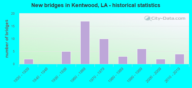
- New bridges - historical statistics
- 21930-1939
- 51950-1959
- 171960-1969
- 101970-1979
- 31980-1989
- 61990-1999
- 22000-2009
- 42010-2019
FCC Registered Antenna Towers: 166 (See the full list of FCC Registered Antenna Towers)
FCC Registered Private Land Mobile Towers: 2 (See the full list of FCC Registered Private Land Mobile Towers in Kentwood, LA)
FCC Registered Broadcast Land Mobile Towers: 6 (See the full list of FCC Registered Broadcast Land Mobile Towers)
FCC Registered Microwave Towers: 16 (See the full list of FCC Registered Microwave Towers in this town)
FCC Registered Amateur Radio Licenses: 34 (See the full list of FCC Registered Amateur Radio Licenses in Kentwood)
FAA Registered Aircraft: 9 (See the full list of FAA Registered Aircraft in Kentwood)
2002 - 2018 National Fire Incident Reporting System (NFIRS) incidents
- Fire incident types reported to NFIRS in Kentwood, LA
- 78059.9%Outside Fires
- 30723.6%Structure Fires
- 19615.0%Mobile Property/Vehicle Fires
- 201.5%Other
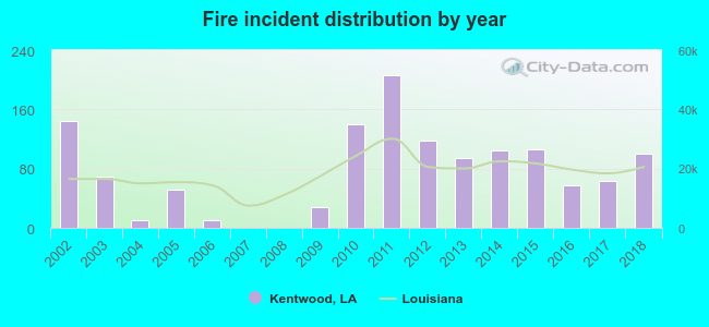 According to the data from the years 2002 - 2018 the average number of fire incidents per year is 77. The highest number of fires - 206 took place in 2011, and the least - 0 in 2007. The data has a declining trend.
 When looking into fire subcategories, the most incidents belonged to: Outside Fires (59.9%), and Structure Fires (23.6%).
| Most common first names in Kentwood, LA among deceased individuals | ||
| Name | Count | Lived (average) |
|---|---|---|
| James | 58 | 73.1 years |
| John | 56 | 72.9 years |
| Mary | 50 | 79.8 years |
| Willie | 49 | 72.4 years |
| William | 41 | 69.9 years |
| Robert | 39 | 70.9 years |
| George | 36 | 73.3 years |
| Charles | 32 | 69.3 years |
| Annie | 25 | 79.8 years |
| Frank | 23 | 74.9 years |
| Most common last names in Kentwood, LA among deceased individuals | ||
| Last name | Count | Lived (average) |
|---|---|---|
| Brumfield | 70 | 72.1 years |
| Smith | 70 | 76.0 years |
| Cutrer | 50 | 74.8 years |
| Williams | 50 | 74.1 years |
| Varnado | 39 | 76.8 years |
| Travis | 38 | 74.3 years |
| Mcdaniel | 35 | 77.2 years |
| Blades | 34 | 74.6 years |
| Dykes | 32 | 78.9 years |
| Alford | 31 | 77.1 years |
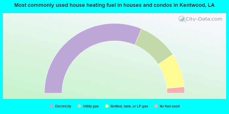
- 62.6%Electricity
- 18.7%Utility gas
- 15.8%Bottled, tank, or LP gas
- 2.9%No fuel used
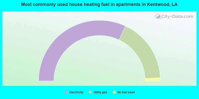
- 64.1%Electricity
- 34.2%Utility gas
- 1.7%No fuel used
Kentwood compared to Louisiana state average:
- Median household income below state average.
- Median house value significantly below state average.
- Hispanic race population percentage significantly below state average.
- Foreign-born population percentage significantly below state average.
- Length of stay since moving in above state average.
- House age above state average.
- Number of college students significantly below state average.
- Percentage of population with a bachelor's degree or higher below state average.
Kentwood on our top lists:
- #89 on the list of "Top 100 least-safe cities (highest city-data.com crime index)"
- #21 on the list of "Top 101 counties with the smallest number of people without health insurance coverage in 2000 (pop. 50,000+)"
- #59 on the list of "Top 101 counties with the largest increase in the number of births per 1000 residents 2000-2006 to 2007-2013 (pop 50,000+)"
- #66 on the list of "Top 101 counties with the smallest number of children under 18 without health insurance coverage in 2000 (pop. 50,000+)"
- #68 on the list of "Top 101 counties with the highest number of births per 1000 residents 2007-2013"
- #72 on the list of "Top 101 counties with the most Black Protestant congregations"

|
Total of 3 patent applications in 2008-2024.