Lancing, Tennessee
Submit your own pictures of this place and show them to the world
- OSM Map
- General Map
- Google Map
- MSN Map

| Males: 1,480 | |
| Females: 1,475 |
| Median resident age: | 36.7 years |
| Tennessee median age: | 35.9 years |
Zip code: 37770
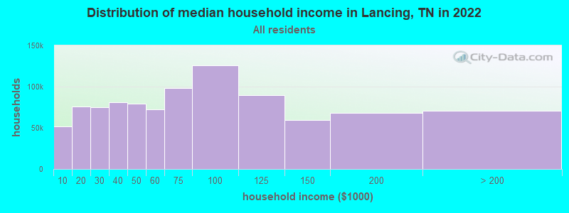
| Lancing: | $46,352 |
| TN: | $65,254 |
Estimated per capita income in 2022: $24,200 (it was $11,242 in 2000)
Lancing CCD income, earnings, and wages data
Estimated median house or condo value in 2022: $151,542 (it was $52,000 in 2000)
| Lancing: | $151,542 |
| TN: | $284,800 |
Detailed information about poverty and poor residents in Lancing, TN


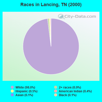
- 2,92598.0%White alone
- 260.9%Two or more races
- 140.5%Hispanic
- 120.4%American Indian alone
- 30.1%Black alone
- 40.1%Asian alone
Races in Lancing detailed stats: ancestries, foreign born residents, place of birth
According to our research of Tennessee and other state lists, there were 8 registered sex offenders living in Lancing, Tennessee as of May 16, 2024.
The ratio of all residents to sex offenders in Lancing is 369 to 1.
The ratio of registered sex offenders to all residents in this city is near the state average.
 Recent articles from our blog. Our writers, many of them Ph.D. graduates or candidates, create easy-to-read articles on a wide variety of topics.
Current Local Time: EST time zone
Elevation: 1189 feet
Land area: 140.5 square miles.
Population density: 21 people per square mile (very low).

| Lancing CCD: | 0.8% ($426) |
| Tennessee: | 0.8% ($715) |
Nearest city with pop. 50,000+: Knoxville, TN  (45.1 miles , pop. 173,890).
Nearest city with pop. 200,000+: Nashville-Davidson, TN (113.9 miles , pop. 545,524).
Nearest city with pop. 1,000,000+: Chicago, IL (425.1 miles , pop. 2,896,016).
Nearest cities:
), ), ), ), ), )Latitude: 36.14 N, Longitude: 84.72 W
Area code commonly used in this area: 423

| Here: | 3.5% |
| Tennessee: | 3.0% |
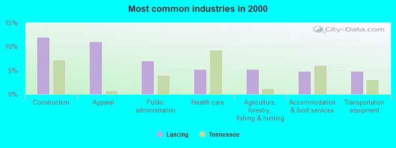
- Construction (12.0%)
- Apparel (11.1%)
- Public administration (7.0%)
- Health care (5.3%)
- Agriculture, forestry, fishing & hunting (5.2%)
- Accommodation & food services (4.9%)
- Transportation equipment (4.8%)
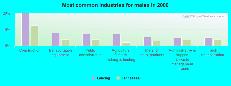
- Construction (19.9%)
- Transportation equipment (8.0%)
- Public administration (7.6%)
- Agriculture, forestry, fishing & hunting (7.2%)
- Metal & metal products (5.3%)
- Administrative & support & waste management services (5.1%)
- Truck transportation (5.0%)
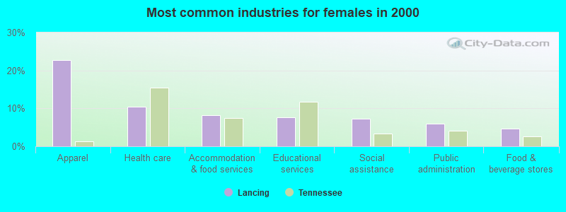
- Apparel (22.7%)
- Health care (10.4%)
- Accommodation & food services (8.1%)
- Educational services (7.7%)
- Social assistance (7.3%)
- Public administration (6.0%)
- Food & beverage stores (4.6%)
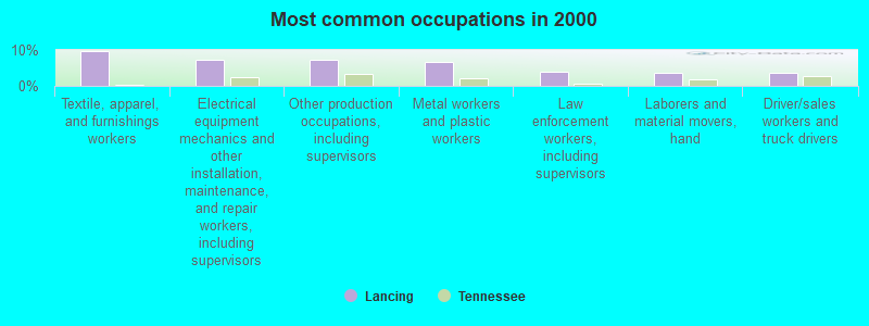
- Textile, apparel, and furnishings workers (9.7%)
- Electrical equipment mechanics and other installation, maintenance, and repair workers, including supervisors (7.4%)
- Other production occupations, including supervisors (7.2%)
- Metal workers and plastic workers (6.7%)
- Law enforcement workers, including supervisors (4.0%)
- Laborers and material movers, hand (3.6%)
- Driver/sales workers and truck drivers (3.6%)
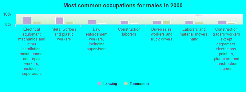
- Electrical equipment mechanics and other installation, maintenance, and repair workers, including supervisors (12.3%)
- Metal workers and plastic workers (11.1%)
- Law enforcement workers, including supervisors (6.6%)
- Construction laborers (6.0%)
- Driver/sales workers and truck drivers (6.0%)
- Laborers and material movers, hand (6.0%)
- Construction traders workers except carpenters, electricians, painters, plumbers, and construction laborers (5.3%)
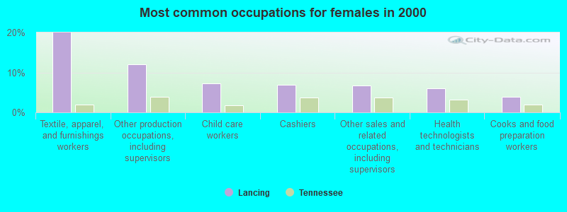
- Textile, apparel, and furnishings workers (20.0%)
- Other production occupations, including supervisors (12.1%)
- Child care workers (7.3%)
- Cashiers (6.9%)
- Other sales and related occupations, including supervisors (6.7%)
- Health technologists and technicians (6.0%)
- Cooks and food preparation workers (4.0%)
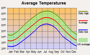
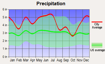
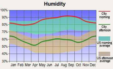
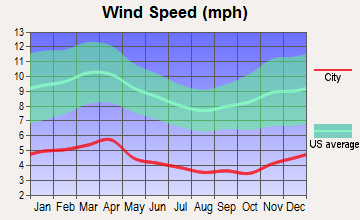
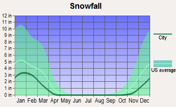
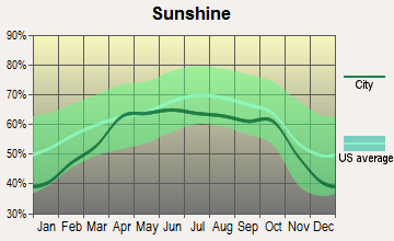
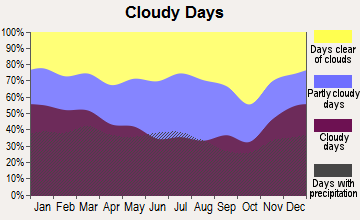
Average climate in Lancing, Tennessee
Based on data reported by over 4,000 weather stations
(lower is better)
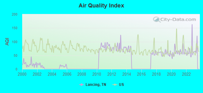
Air Quality Index (AQI) level in 2022 was 66.1. This is about average.
| City: | 66.1 |
| U.S.: | 72.6 |
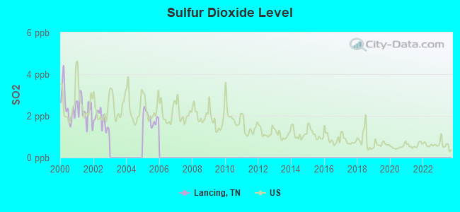
Sulfur Dioxide (SO2) [ppb] level in 2005 was 1.89. This is worse than average. Closest monitor was 14.4 miles away from the city center.
| City: | 1.89 |
| U.S.: | 1.51 |
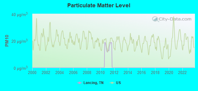
Particulate Matter (PM10) [µg/m3] level in 2011 was 15.8. This is better than average. Closest monitor was 17.1 miles away from the city center.
| City: | 15.8 |
| U.S.: | 19.2 |
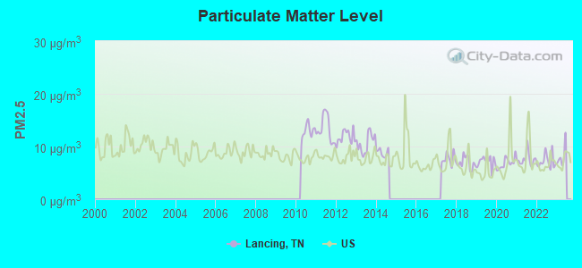
Particulate Matter (PM2.5) [µg/m3] level in 2022 was 7.19. This is about average. Closest monitor was 17.1 miles away from the city center.
| City: | 7.19 |
| U.S.: | 8.11 |
Tornado activity:
Lancing-area historical tornado activity is slightly below Tennessee state average. It is 3% greater than the overall U.S. average.
On 4/3/1974, a category F4 (max. wind speeds 207-260 mph) tornado 21.0 miles away from the Lancing place center killed 7 people and injured 150 people and caused between $500,000 and $5,000,000 in damages.
On 4/3/1974, a category F4 tornado 24.0 miles away from the place center killed 10 people and injured 51 people and caused between $500,000 and $5,000,000 in damages.
Earthquake activity:
Lancing-area historical earthquake activity is significantly above Tennessee state average. It is 105% greater than the overall U.S. average.On 7/27/1980 at 18:52:21, a magnitude 5.2 (5.1 MB, 4.7 MS, 5.0 UK, 5.2 UK, Class: Moderate, Intensity: VI - VII) earthquake occurred 149.2 miles away from the city center
On 11/30/1973 at 07:48:41, a magnitude 4.7 (4.7 MB, 4.6 ML, Class: Light, Intensity: IV - V) earthquake occurred 48.6 miles away from Lancing center
On 4/29/2003 at 08:59:39, a magnitude 4.9 (4.4 MB, 4.6 MW, 4.9 LG) earthquake occurred 124.8 miles away from the city center
On 4/18/2008 at 09:36:59, a magnitude 5.4 (5.1 MB, 4.8 MS, 5.4 MW, 5.2 MW) earthquake occurred 236.4 miles away from the city center
On 12/12/2018 at 09:14:43, a magnitude 4.4 (4.4 MW, Depth: 4.9 mi) earthquake occurred 36.5 miles away from Lancing center
On 8/9/2020 at 12:07:37, a magnitude 5.1 (5.1 MW, Depth: 4.7 mi) earthquake occurred 203.6 miles away from Lancing center
Magnitude types: regional Lg-wave magnitude (LG), body-wave magnitude (MB), local magnitude (ML), surface-wave magnitude (MS), moment magnitude (MW)
Natural disasters:
The number of natural disasters in Morgan County (16) is near the US average (15).Major Disasters (Presidential) Declared: 11
Emergencies Declared: 2
Causes of natural disasters: Floods: 11, Storms: 10, Tornadoes: 4, Winter Storms: 4, Flash Flood: 1, Hurricane: 1, Ice Storm: 1, Landslide: 1, Mudslide: 1, Snowfall: 1, Wind: 1, Other: 1 (Note: some incidents may be assigned to more than one category).
Colleges/universities with over 2000 students nearest to Lancing:
- Roane State Community College (about 19 miles; Harriman, TN; Full-time enrollment: 4,302)
- Pellissippi State Community College (about 34 miles; Knoxville, TN; FT enrollment: 7,271)
- Tennessee Technological University (about 44 miles; Cookeville, TN; FT enrollment: 9,761)
- The University of Tennessee-Knoxville (about 47 miles; Knoxville, TN; FT enrollment: 25,483)
- University of the Cumberlands (about 52 miles; Williamsburg, KY; FT enrollment: 3,585)
- Somerset Community College (about 64 miles; Somerset, KY; FT enrollment: 4,698)
- Cleveland State Community College (about 66 miles; Cleveland, TN; FT enrollment: 2,500)
Points of interest:
Notable locations in Lancing: Twin Bridges (A), Clear Creek Junction (B), Clarence B Lane Memorial Park and Firehall / Chestnut Ridge Volunteer Fire Department (C). Display/hide their locations on the map
Churches in Lancing include: Fairview Church (A), Flat Rock Church (B), Shady Grove Church (C), Potter Chapel (D), Pleasant Green Church (E), Clear Creek Church (F), Oak Grove Church (G), Cane Branch Church (H), Elizabeth Church (I). Display/hide their locations on the map
Cemeteries: Howard Cemetery (1), Hall Cemetery (2), Potters Chapel Cemetery (3), Pilot Mountain Cemetery (4), Nitzschke Cemetery (5), McCoy Cemetery (6), Friends Chapel Cemetery (7). Display/hide their locations on the map
Streams, rivers, and creeks: Lyons Branch (A), Long Branch (B), Little Rock Creek (C), Little Creek (D), Bice Creek (E), Langley Branch (F), Young Creek (G), Jones Branch (H), Jim Branch (I). Display/hide their locations on the map
| This place: | 2.6 people |
| Tennessee: | 2.5 people |
| This place: | 69.3% |
| Whole state: | 69.8% |
| This place: | 5.3% |
| Whole state: | 4.2% |
Likely homosexual households (counted as self-reported same-sex unmarried-partner households)
- Lesbian couples: 0.2% of all households
- Gay men: 0.0% of all households
| This place: | 20.6% |
| Whole state: | 13.5% |
| This place: | 9.7% |
| Whole state: | 5.8% |
For population 15 years and over in Lancing:
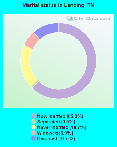
- Never married: 18.7%
- Now married: 62.8%
- Separated: 0.9%
- Widowed: 6.9%
- Divorced: 11.5%
For population 25 years and over in Lancing:
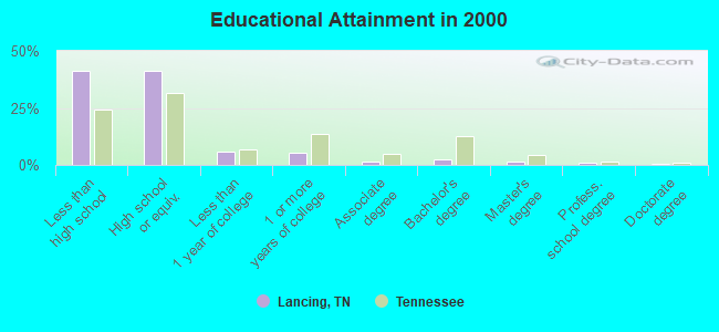
- High school or higher: 58.9%
- Bachelor's degree or higher: 5.1%
- Graduate or professional degree: 2.5%
- Unemployed: 7.8%
- Mean travel time to work (commute): 39.9 minutes
| Here: | 13.1 |
| Tennessee average: | 13.3 |
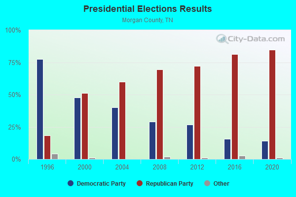
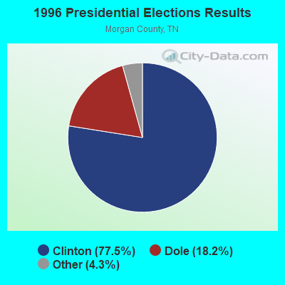
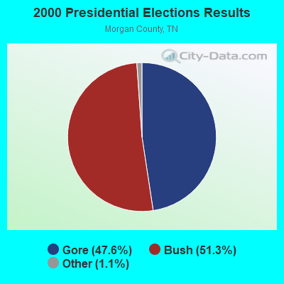
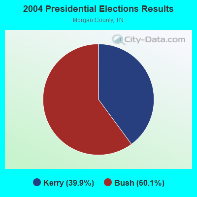

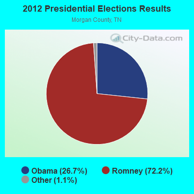
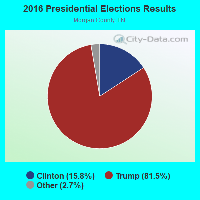
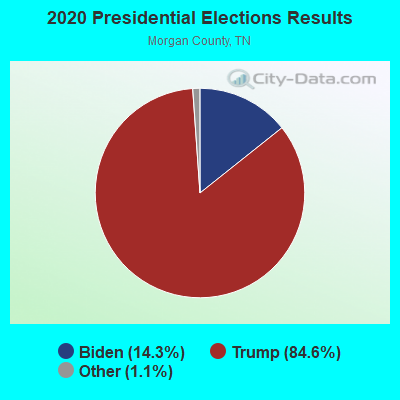
Graphs represent county-level data. Detailed 2008 Election Results
Religion statistics for Lancing, TN (based on Morgan County data)
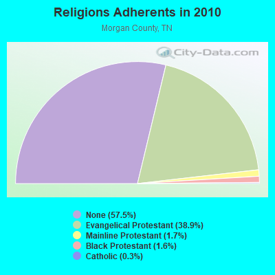
| Religion | Adherents | Congregations |
|---|---|---|
| Evangelical Protestant | 8,556 | 32 |
| Mainline Protestant | 369 | 8 |
| Black Protestant | 357 | 2 |
| Catholic | 56 | 1 |
| Other | 1 | 1 |
| None | 12,648 | - |
Food Environment Statistics:
| Morgan County: | 2.46 / 10,000 pop. |
| Tennessee: | 1.99 / 10,000 pop. |
| This county: | 0.98 / 10,000 pop. |
| Tennessee: | 0.65 / 10,000 pop. |
| Morgan County: | 5.41 / 10,000 pop. |
| State: | 5.16 / 10,000 pop. |
| This county: | 1.97 / 10,000 pop. |
| Tennessee: | 6.56 / 10,000 pop. |
| Morgan County: | 11.3% |
| Tennessee: | 11.4% |
| This county: | 29.2% |
| Tennessee: | 30.2% |
| Morgan County: | 14.0% |
| Tennessee: | 13.5% |
Strongest AM radio stations in Lancing:
- WECO (940 AM; 5 kW; WARTBURG, TN; Owner: MORGAN COUNTY B/CASTING CO.)
- WKVL (850 AM; daytime; 50 kW; KNOXVILLE, TN; Owner: HORNE RADIO, LLC)
- WWAM (820 AM; daytime; 50 kW; JASPER, TN; Owner: SHELTON BROADCASTING SYSTEM)
- WFLI (1070 AM; 50 kW; LOOKOUT MOUNTAIN, TN; Owner: WFLI, INC.)
- WQBB (1040 AM; daytime; 10 kW; POWELL, TN; Owner: JOURNAL BROADCAST CORPORATION)
- WSM (650 AM; 50 kW; NASHVILLE, TN; Owner: GAYLORD ENTERTAINMENT COMPANY)
- WNOX (990 AM; 10 kW; KNOXVILLE, TN)
- WATO (1290 AM; 5 kW; OAK RIDGE, TN)
- WAMB (1160 AM; 50 kW; DONELSON, TN; Owner: GREAT SOUTHERN BROADCASTING COMPANY, INC.)
- WMTY (670 AM; daytime; 2 kW; FARRAGUT, TN; Owner: HORNE RADIO, LLC)
- WOFE (580 AM; 1 kW; ROCKWOOD, TN; Owner: SOUTHERN MEDIA GROUP, INC.)
- WVLZ (1180 AM; daytime; 10 kW; KNOXVILLE, TN; Owner: KIRKLAND WIRELESS BROADCASTERS, INC.)
- WLFJ (660 AM; daytime; 50 kW; GREENVILLE, SC; Owner: CLEAR CHANNEL BROADCASTING LICENSES, INC.)
Strongest FM radio stations in Lancing:
- WECO-FM (101.3 FM; WARTBURG, TN; Owner: MORGAN COUNTY BROADCASTING CO., INC.)
- WDVX (89.9 FM; CLINTON, TN; Owner: CUMBERLAND COMMUNITIES COMMUNI CORP.)
- WWSR (105.7 FM; ROCKWOOD, TN; Owner: SOUTHERN MEDIA GROUP, INC.)
- WOWF (102.5 FM; CROSSVILLE, TN; Owner: PEG BROADCASTING, INC.)
- WMKW (89.3 FM; CROSSVILLE, TN; Owner: THE MOODY BIBLE INSTITUTE OF CHICAGO)
- WBZH (92.7 FM; HARRIMAN, TN; Owner: SOUTHERN MEDIA GROUP, INC.)
- WOKI-FM (100.3 FM; OAK RIDGE, TN; Owner: OAK RIDGE FM, INC.)
- WGSQ (94.7 FM; COOKEVILLE, TN; Owner: CLEAR CHANNEL BROADCASTING LICENSES, INC.)
- WCLC-FM (105.1 FM; JAMESTOWN, TN; Owner: BIBLE BELIEVERS NETWORK, INC.)
- WUOT (91.9 FM; KNOXVILLE, TN; Owner: UNIVERSITY OF TENNESSEE)
- WIVK-FM (107.7 FM; KNOXVILLE, TN; Owner: CITADEL BROADCASTING COMPANY)
- WKXD-FM (106.9 FM; MONTEREY, TN; Owner: JWC BROADCASTING)
- WIMZ-FM (103.5 FM; KNOXVILLE, TN; Owner: SOUTH CENTRAL COMM., CORP.)
- WJXB-FM (97.5 FM; KNOXVILLE, TN; Owner: SOUTH CENTRAL COMMUNICATIONS CORP.)
- WKTS (90.1 FM; KINGSTON, TN; Owner: THE KINGSTON CENTURY CLUB INC.)
- WAYA (93.9 FM; SPRING CITY, TN; Owner: J. L. BREWER BROADCASTING OF CLEVELAND, LLC)
- WLIV-FM (104.7 FM; MONTEREY, TN; Owner: WKXN INC)
- WDEB-FM (103.9 FM; JAMESTOWN, TN; Owner: BAZ BROADCASTING, INC.)
- WLQK (95.9 FM; LIVINGSTON, TN; Owner: JWC BROADCASTING)
- WYLV (89.1 FM; ALCOA, TN; Owner: FOOTHILLS BROADCASTING, INC.)
TV broadcast stations around Lancing:
- WDTT-LP (Channel 38; LENOIR CITY, TN; Owner: WORD OF GOD FELLOWSHIP, INC.)
- WBXX-TV (Channel 20; CROSSVILLE, TN; Owner: ACME TV LICENSES OF TENNESSEE, LLC)
- WVLT-TV (Channel 8; KNOXVILLE, TN; Owner: WVLT LICENSEE CORP.)
- WKOP-TV (Channel 15; KNOXVILLE, TN; Owner: EAST TENNESSEE PUBLIC COMMUNICATIONS CORP.)
- WBIR-TV (Channel 10; KNOXVILLE, TN; Owner: GANNETT PACIFIC CORPORATION)
- WATE-TV (Channel 6; KNOXVILLE, TN; Owner: WATE, G.P.)
- WTNZ (Channel 43; KNOXVILLE, TN; Owner: RAYCOM AMERICA, INC.)
- W46DC (Channel 46; KNOXVILLE, TN; Owner: TRINITY BROADCASTING NETWORK)
- WCTE (Channel 22; COOKEVILLE, TN; Owner: UPPER CUMBERLAND BROADCAST COUNCIL)
- WEEE-LP (Channel 32; KNOXVILLE, TN; Owner: TIGER EYE BROADCASTING CORPORATION)
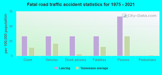
Lancing fatal accident list:
FCC Registered Antenna Towers:
27 (See the full list of FCC Registered Antenna Towers in Lancing)FCC Registered Amateur Radio Licenses:
8 (See the full list of FCC Registered Amateur Radio Licenses in Lancing)FAA Registered Aircraft:
1- Aircraft: WALLACE STEVE MERLIN GT (Category: Land, Seats: 2, Weight: Up to 12,499 Pounds), Engine: Reciprocating
N-Number: 50963, N50963, N-50963, Serial Number: 1118, Certificate Issue Date: 07/20/2006
Registrant (Individual): Steve L Wallace, 128 James Brown Rd, Lancing, TN 37770
Deregistered: Cancel Date: 10/21/1998
2003 - 2018 National Fire Incident Reporting System (NFIRS) incidents
- Fire incident types reported to NFIRS in Lancing, TN
- 16650.5%Outside Fires
- 12538.0%Structure Fires
- 298.8%Mobile Property/Vehicle Fires
- 92.7%Other
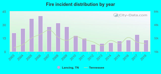 According to the data from the years 2003 - 2018 the average number of fire incidents per year is 21. The highest number of fire incidents - 40 took place in 2006, and the least - 8 in 2012. The data has a decreasing trend.
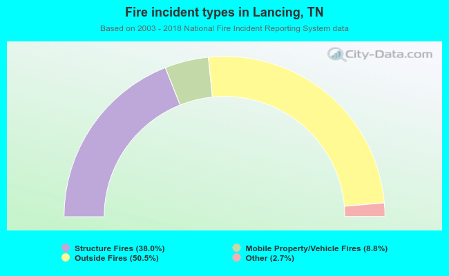 When looking into fire subcategories, the most incidents belonged to: Outside Fires (50.5%), and Structure Fires (38.0%).
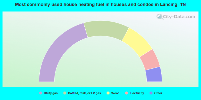
- 41.2%Utility gas
- 24.2%Bottled, tank, or LP gas
- 16.7%Wood
- 10.0%Electricity
- 3.9%Other fuel
- 3.3%Fuel oil, kerosene, etc.
- 0.7%No fuel used
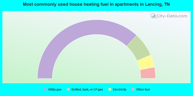
- 73.8%Utility gas
- 13.1%Bottled, tank, or LP gas
- 6.9%Electricity
- 6.2%Other fuel
Lancing compared to Tennessee state average:
- Median house value below state average.
- Unemployed percentage below state average.
- Black race population percentage significantly below state average.
- Hispanic race population percentage significantly below state average.
- Foreign-born population percentage significantly below state average.
- Renting percentage significantly below state average.
- Length of stay since moving in significantly above state average.
- Number of rooms per house significantly below state average.
- House age significantly below state average.
- Number of college students below state average.
- Percentage of population with a bachelor's degree or higher significantly below state average.

|
Total of 4 patent applications in 2008-2024.