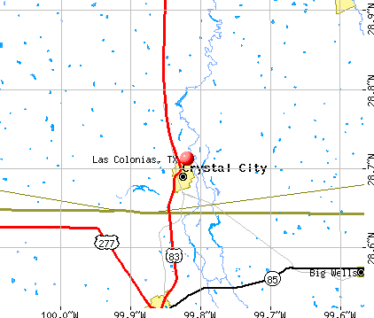
Las Colonias, Texas
Submit your own pictures of this place and show them to the world
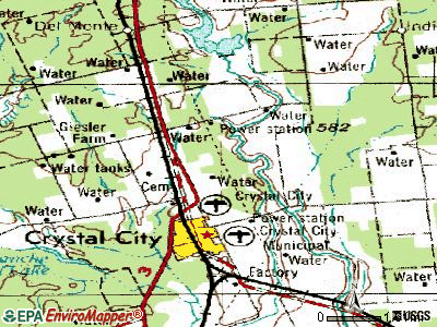
- OSM Map
- General Map
- Google Map
- MSN Map
| Males: 146 | |
| Females: 138 |
| Median resident age: | 28.1 years |
| Texas median age: | 32.3 years |
Zip codes: 78839.
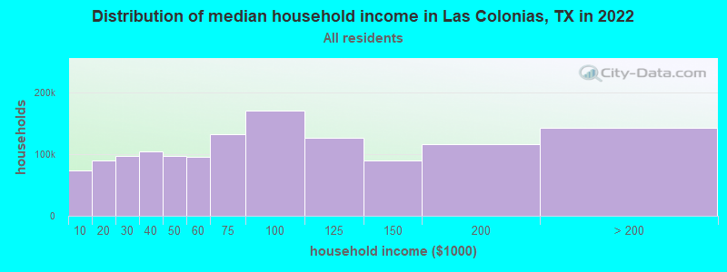
| Las Colonias: | $27,728 |
| TX: | $72,284 |
Estimated per capita income in 2022: $24,296 (it was $11,754 in 2000)
Las Colonias CDP income, earnings, and wages data
Estimated median house or condo value in 2022: $97,612 (it was $26,300 in 2000)
| Las Colonias: | $97,612 |
| TX: | $275,400 |
Detailed information about poverty and poor residents in Las Colonias, TX
Compare current foreclosures near Las Colonias, TX:
| Photo | Address | Area | Beds / Baths | Price | Details |
|---|---|---|---|---|---|

|
#1
Highway 277
Carrizo Springs, TX 78834
|
2,506 sq. feet
|
3 baths 3 beds |
show details | |

|
#2
County Road 9742
Carrizo Springs, TX 78834
|
1,920 sq. feet
|
2 baths 4 beds |
show details | |

|
#3
S 7th Ave
Crystal City, TX 78839
|
2,380 sq. feet
|
- baths - beds |
show details | |

|
#4
E Alamo St
Carrizo Springs, TX 78834
|
- sq. feet
|
- baths - beds |
show details | |

|
#5
N 5th Ave
Crystal City, TX 78839
|
- sq. feet
|
- baths - beds |
show details | |

|
Check over 1 million property listings on Foreclosure.com!
|
browse all offers | |||

- 25991.5%Hispanic
- 248.5%White alone
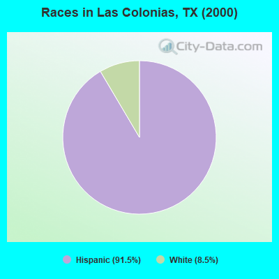
Races in Las Colonias detailed stats: ancestries, foreign born residents, place of birth
 Recent articles from our blog. Our writers, many of them Ph.D. graduates or candidates, create easy-to-read articles on a wide variety of topics.

 | Does everyone stay inside in SA in the summer? (36 replies) |
| Help please! Possible S. TX move from NE GA. (17 replies) |
Latest news from Las Colonias, TX collected exclusively by city-data.com from local newspapers, TV, and radio stations
Ancestries: Swedish (7.1%), Dutch (4.2%), English (2.8%), German (2.8%), West Indian (2.8%).
Current Local Time: CST time zone
Land area: 13.5 square miles.
Population density: 21 people per square mile (very low).
21 residents are foreign born (7.4% Latin America).
| This place: | 7.4% |
| Texas: | 13.9% |
| Las Colonias CDP: | 0.8% ($199) |
| Texas: | 1.8% ($1,393) |
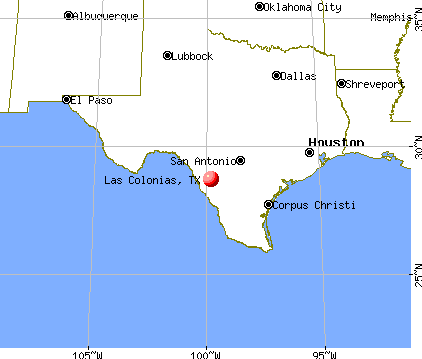
Nearest city with pop. 50,000+: Laredo, TX  (84.6 miles , pop. 176,576).
Nearest city with pop. 200,000+: San Antonio, TX (94.1 miles , pop. 1,144,646).
Nearest cities:
), ), )Latitude: 28.71 N, Longitude: 99.82 W
Daytime population change due to commuting: +2,817 (+995.4%)
Workers who live and work in this place: 0 (0.0%)
Area code commonly used in this area: 830
| Here: | 6.0% |
| Texas: | 3.5% |
Average climate in Las Colonias, Texas
Based on data reported by over 4,000 weather stations


Tornado activity:
Las Colonias-area historical tornado activity is significantly below Texas state average. It is 70% smaller than the overall U.S. average.
On 4/15/1973, a category F4 (max. wind speeds 207-260 mph) tornado 37.3 miles away from the Las Colonias place center killed 5 people and injured 12 people.
On 5/23/1966, a category F2 (max. wind speeds 113-157 mph) tornado 1.1 miles away from the place center .
Earthquake activity:
Las Colonias-area historical earthquake activity is significantly above Texas state average. It is 29% smaller than the overall U.S. average.On 4/14/1995 at 00:32:56, a magnitude 5.7 (5.6 MB, 5.7 MS, 5.7 MW, Depth: 11.1 mi, Class: Moderate, Intensity: VI - VII) earthquake occurred 239.5 miles away from Las Colonias center
On 10/20/2011 at 12:24:41, a magnitude 4.8 (4.8 MW, Depth: 3.1 mi, Class: Light, Intensity: IV - V) earthquake occurred 106.0 miles away from Las Colonias center
On 4/9/1993 at 12:29:19, a magnitude 4.3 (4.1 MB, 4.3 LG, Depth: 3.1 mi) earthquake occurred 103.0 miles away from the city center
On 6/16/1978 at 11:46:54, a magnitude 5.3 (4.4 MB, 4.6 UK, 5.3 ML) earthquake occurred 303.9 miles away from Las Colonias center
On 5/1/2018 at 16:28:56, a magnitude 4.0 (4.0 MW, Depth: 3.1 mi) earthquake occurred 111.4 miles away from the city center
On 4/7/2008 at 09:51:12, a magnitude 3.9 (3.9 MW, Depth: 3.1 mi, Class: Light, Intensity: II - III) earthquake occurred 109.1 miles away from the city center
Magnitude types: regional Lg-wave magnitude (LG), body-wave magnitude (MB), local magnitude (ML), surface-wave magnitude (MS), moment magnitude (MW)
Natural disasters:
The number of natural disasters in Zavala County (11) is smaller than the US average (15).Major Disasters (Presidential) Declared: 6
Emergencies Declared: 4
Causes of natural disasters: Hurricanes: 4, Storms: 4, Floods: 3, Fires: 2, Tornadoes: 2, Wind: 1, Other: 1 (Note: some incidents may be assigned to more than one category).
Hospitals and medical centers near Las Colonias:
- LOPEZ HEALTH SYSTEMS INC (Home Health Center, about 2 miles away; CRYSTAL CITY, TX)
- DIMMIT REGIONAL HOSPITAL Acute Care Hospitals (about 14 miles away; CARRIZO SPRINGS, TX)
- FMC CARIZZO SPRINGS KIDNEY DISEASE CLINIC (Dialysis Facility, about 14 miles away; CARRIZO SPRINGS, TX)
- CANTERBURY VILLA OF CARRIZO SPRINGS (Nursing Home, about 14 miles away; CARRIZO SPRINGS, TX)
- CARRIZO SPRINGS NURSING AND REHABILITATION LP (Nursing Home, about 14 miles away; CARRIZO SPRINGS, TX)
Colleges/universities with over 2000 students nearest to Las Colonias:
- Southwest Texas Junior College (about 36 miles; Uvalde, TX; Full-time enrollment: 3,569)
- Texas A & M International University (about 83 miles; Laredo, TX; FT enrollment: 5,203)
- Northwest Vista College (about 86 miles; San Antonio, TX; FT enrollment: 9,683)
- Laredo Community College (about 86 miles; Laredo, TX; FT enrollment: 9,743)
- Palo Alto College (about 88 miles; San Antonio, TX; FT enrollment: 5,055)
- Our Lady of the Lake University (about 92 miles; San Antonio, TX; FT enrollment: 2,133)
- The University of Texas at San Antonio (about 95 miles; San Antonio, TX; FT enrollment: 25,503)
Points of interest:
| This place: | 3.7 people |
| Texas: | 2.7 people |
| This place: | 89.5% |
| Whole state: | 71.5% |
| This place: | 2.6% |
| Whole state: | 4.4% |
No gay or lesbian households reported
| This place: | 66.2% |
| Whole state: | 15.4% |
| This place: | 27.1% |
| Whole state: | 6.7% |
For population 15 years and over in Las Colonias:
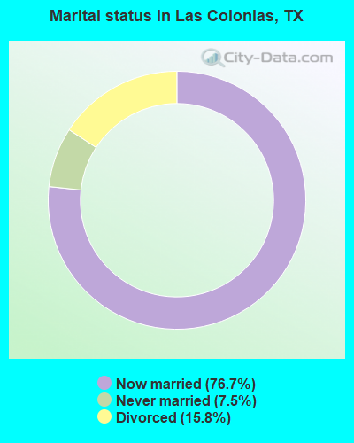
- Never married: 7.5%
- Now married: 76.7%
- Separated: 0.0%
- Widowed: 0.0%
- Divorced: 15.8%
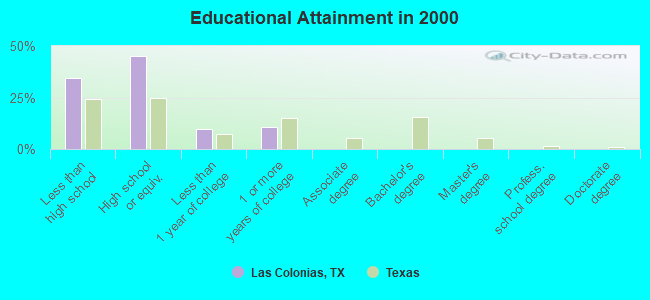
For population 25 years and over in Las Colonias:
- High school or higher: 65.8%
- Bachelor's degree or higher: 0.0%
- Graduate or professional degree: 0.0%
- Unemployed: 11.7%
- Mean travel time to work (commute): 18.8 minutes
| Here: | 15.8 |
| Texas average: | 15.6 |
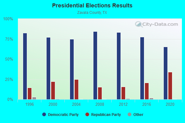
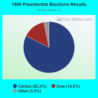
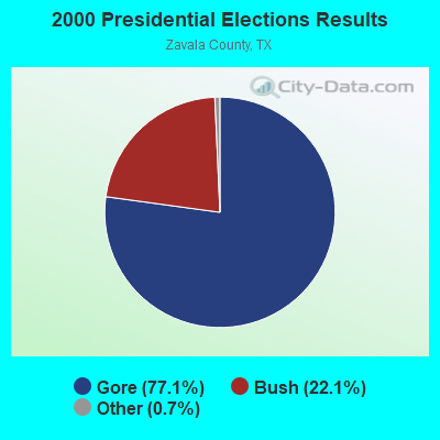
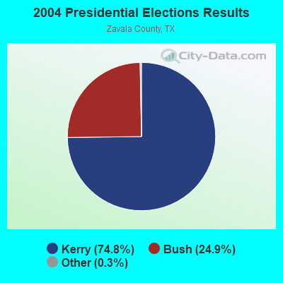

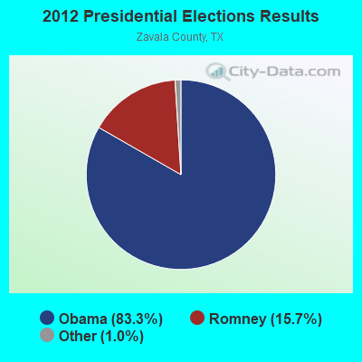
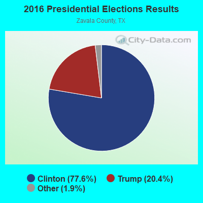
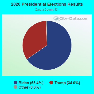
Graphs represent county-level data. Detailed 2008 Election Results
Religion statistics for Las Colonias, TX (based on Zavala County data)
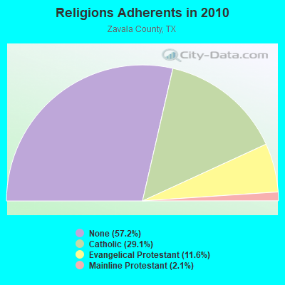
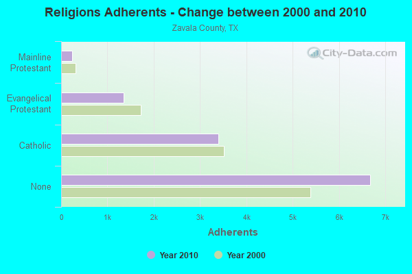
| Religion | Adherents | Congregations |
|---|---|---|
| Catholic | 3,400 | 2 |
| Evangelical Protestant | 1,355 | 11 |
| Mainline Protestant | 240 | 2 |
| Other | 2 | - |
| None | 6,680 | - |
Food Environment Statistics:
| Zavala County: | 3.44 / 10,000 pop. |
| State: | 1.47 / 10,000 pop. |
| Zavala County: | 0.86 / 10,000 pop. |
| Texas: | 1.11 / 10,000 pop. |
| Here: | 5.16 / 10,000 pop. |
| State: | 3.95 / 10,000 pop. |
| Zavala County: | 3.44 / 10,000 pop. |
| Texas: | 6.13 / 10,000 pop. |
| This county: | 8.7% |
| State: | 8.9% |
| Here: | 27.8% |
| State: | 26.6% |
| Zavala County: | 21.9% |
| Texas: | 15.7% |
Strongest AM radio stations in Las Colonias:
- KKYX (680 AM; 50 kW; SAN ANTONIO, TX; Owner: CXR HOLDINGS, INC.)
- KTKR (760 AM; 50 kW; SAN ANTONIO, TX; Owner: CCB TEXAS LICENSES, L.P.)
- KVOZ (890 AM; 12 kW; DEL MAR HILLS, TX; Owner: CONSOLIDATED RADIO, INC.)
- KBEN (1450 AM; 1 kW; CARRIZO SPRINGS, TX; Owner: SYLVIA MIJARES)
- WOAI (1200 AM; 50 kW; SAN ANTONIO, TX; Owner: CCB TEXAS LICENSES, L.P.)
- KENS (1160 AM; 25 kW; SAN ANTONIO, TX; Owner: KENS-TV, INC.)
- KCTA (1030 AM; 50 kW; CORPUS CHRISTI, TX; Owner: BROADCASTING CORPORATION OF THE SOUTHWEST)
- KSAH (720 AM; 10 kW; UNIVERSAL CITY, TX; Owner: KSAH LICENSING, INC.)
- KDRY (1100 AM; 11 kW; ALAMO HEIGHTS, TX; Owner: KDRY RADIO, INC.)
- KGBT (1530 AM; 50 kW; HARLINGEN, TX; Owner: TICHENOR LICENSE CORPORATION)
- KTSA (550 AM; 5 kW; SAN ANTONIO, TX; Owner: INFINITY BROADCASTING CORPORATION OF SAN ANTONIO)
- KSLR (630 AM; 5 kW; SAN ANTONIO, TX; Owner: SALEM MEDIA OF TEXAS, INC.)
- KTRH (740 AM; 50 kW; HOUSTON, TX; Owner: AMFM TEXAS LICENSES LIMITED PARTNERSHIP)
Strongest FM radio stations in Las Colonias:
- KHER (94.3 FM; CRYSTAL CITY, TX; Owner: SYLVIA MIJARES)
- KCZO (92.1 FM; CARRIZO SPRINGS, TX; Owner: PAULINO BERNAL EVANGELISM)
- KBNU (93.9 FM; UVALDE, TX; Owner: RADIO CACTUS, LTD.)
- KLMO-FM (98.9 FM; DILLEY, TX; Owner: DILLEY BROADCASTERS)
TV broadcast stations around Las Colonias:
- KVAW (Channel 16; EAGLE PASS, TX; Owner: HISPANIC TELEVISION NETWORK, INC., DEBTOR IN POSSESSION)
- National Bridge Inventory (NBI) Statistics
- 2Number of bridges
- 13ft / 4.4mTotal length
- 534Total average daily traffic
- 28Total average daily truck traffic
- 1,020Total future (year 2033) average daily traffic
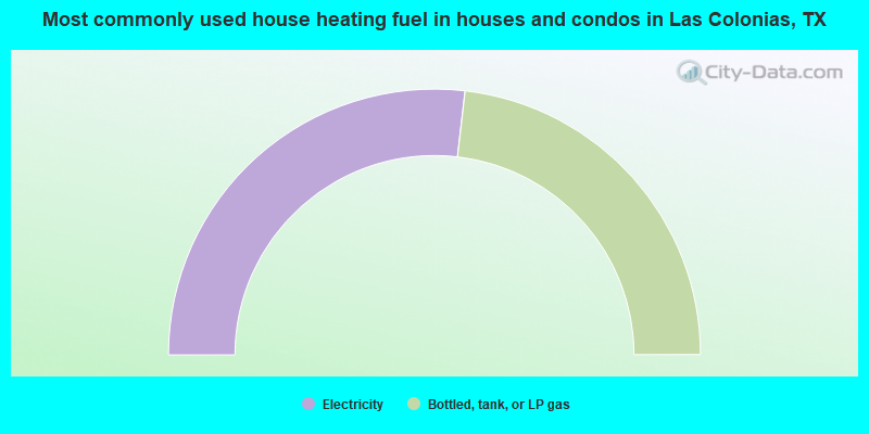
- 53.7%Electricity
- 46.3%Bottled, tank, or LP gas
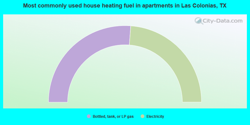
- 52.4%Bottled, tank, or LP gas
- 47.6%Electricity
Las Colonias compared to Texas state average:
- Median household income significantly below state average.
- Median house value significantly below state average.
- Black race population percentage significantly below state average.
- Hispanic race population percentage above state average.
- Foreign-born population percentage below state average.
- Renting percentage significantly below state average.
- Length of stay since moving in significantly above state average.
- Number of rooms per house significantly below state average.
- House age significantly below state average.
- Percentage of population with a bachelor's degree or higher significantly below state average.