Laurel Fork, Tennessee
Submit your own pictures of this place and show them to the world
- OSM Map
- General Map
- Google Map
- MSN Map

| Males: 824 | |
| Females: 808 |
| Median resident age: | 40.5 years |
| Tennessee median age: | 35.9 years |
Zip code: 37640
| Laurel Fork: | $39,920 |
| TN: | $65,254 |
Estimated per capita income in 2022: $25,202 (it was $12,825 in 2000)
Laurel Fork CCD income, earnings, and wages data
Estimated median house or condo value in 2022: $134,419 (it was $51,600 in 2000)
| Laurel Fork: | $134,419 |
| TN: | $284,800 |
Mean prices in 2022: all housing units: $224,307; detached houses: $249,880; townhouses or other attached units: $153,446; in 3-to-4-unit structures: $259,597; in 5-or-more-unit structures: $161,690; mobile homes: $91,475; occupied boats, rvs, vans, etc.: $127,664
Detailed information about poverty and poor residents in Laurel Fork, TN


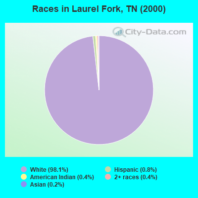
- 1,54498.1%White alone
- 130.8%Hispanic
- 70.4%American Indian alone
- 70.4%Two or more races
- 30.2%Asian alone
Races in Laurel Fork detailed stats: ancestries, foreign born residents, place of birth
 Recent articles from our blog. Our writers, many of them Ph.D. graduates or candidates, create easy-to-read articles on a wide variety of topics.
Current Local Time: EST time zone
Elevation: 3440 feet
Land area: 73.4 square miles.
Population density: 22 people per square mile (very low).

| Laurel Fork CCD: | 0.5% ($275) |
| Tennessee: | 0.8% ($715) |
Nearest city with pop. 50,000+: Johnson City, TN  (19.4 miles , pop. 55,469).
Nearest city with pop. 200,000+: Charlotte, NC (100.2 miles , pop. 540,828).
Nearest city with pop. 1,000,000+: Philadelphia, PA (454.4 miles , pop. 1,517,550).
Nearest cities:
), ), ), ), Latitude: 36.28 N, Longitude: 82.03 W
Area code commonly used in this area: 423

| Here: | 3.3% |
| Tennessee: | 3.0% |
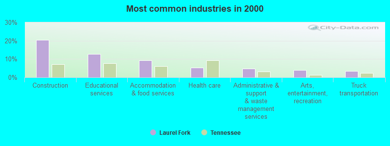
- Construction (20.4%)
- Educational services (12.7%)
- Accommodation & food services (9.2%)
- Health care (5.2%)
- Administrative & support & waste management services (4.8%)
- Arts, entertainment, recreation (4.0%)
- Truck transportation (3.5%)
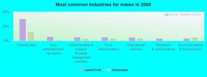
- Construction (30.3%)
- Arts, entertainment, recreation (5.9%)
- Administrative & support & waste management services (5.4%)
- Truck transportation (5.2%)
- Educational services (4.9%)
- Petroleum & coal products (3.5%)
- Accommodation & food services (3.5%)
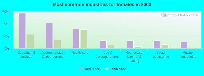
- Educational services (28.8%)
- Accommodation & food services (21.0%)
- Health care (16.1%)
- Food & beverage stores (6.3%)
- Real estate & rental & leasing (6.3%)
- Social assistance (6.3%)
- Private households (5.9%)
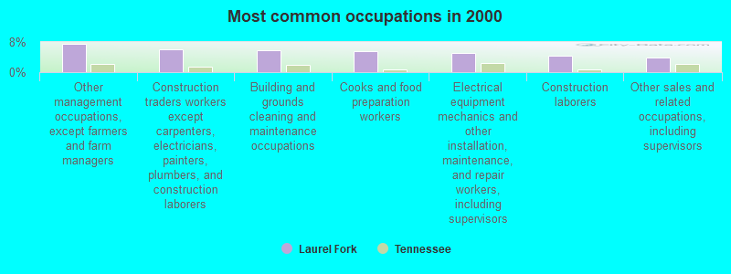
- Other management occupations, except farmers and farm managers (7.4%)
- Construction traders workers except carpenters, electricians, painters, plumbers, and construction laborers (6.0%)
- Building and grounds cleaning and maintenance occupations (5.9%)
- Cooks and food preparation workers (5.5%)
- Electrical equipment mechanics and other installation, maintenance, and repair workers, including supervisors (5.1%)
- Construction laborers (4.3%)
- Other sales and related occupations, including supervisors (4.0%)
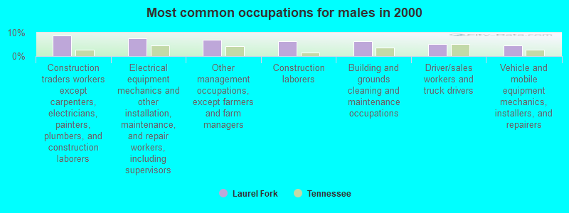
- Construction traders workers except carpenters, electricians, painters, plumbers, and construction laborers (8.9%)
- Electrical equipment mechanics and other installation, maintenance, and repair workers, including supervisors (7.5%)
- Other management occupations, except farmers and farm managers (7.0%)
- Construction laborers (6.3%)
- Building and grounds cleaning and maintenance occupations (6.3%)
- Driver/sales workers and truck drivers (5.2%)
- Vehicle and mobile equipment mechanics, installers, and repairers (4.7%)
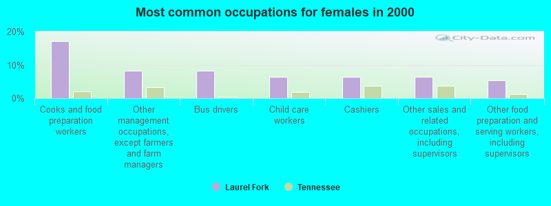
- Cooks and food preparation workers (17.1%)
- Other management occupations, except farmers and farm managers (8.3%)
- Bus drivers (8.3%)
- Child care workers (6.3%)
- Cashiers (6.3%)
- Other sales and related occupations, including supervisors (6.3%)
- Other food preparation and serving workers, including supervisors (5.4%)
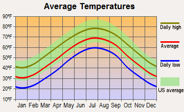
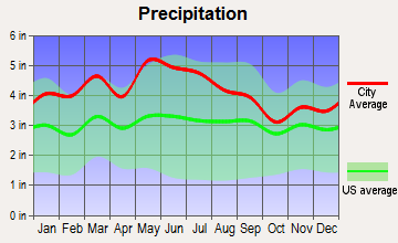
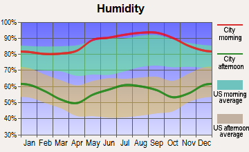
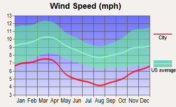
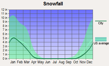
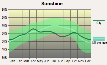
Average climate in Laurel Fork, Tennessee
Based on data reported by over 4,000 weather stations

(lower is better)
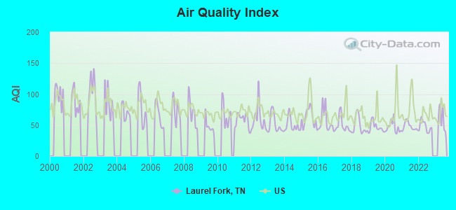
Air Quality Index (AQI) level in 2022 was 48.5. This is significantly better than average.
| City: | 48.5 |
| U.S.: | 72.6 |
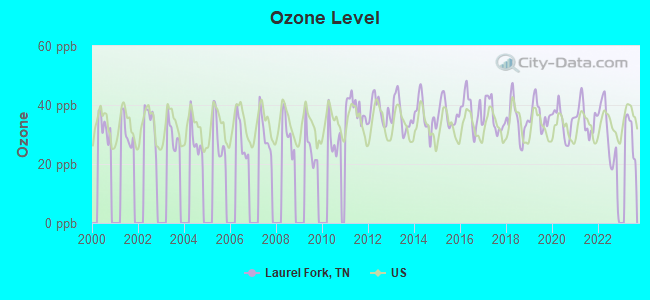
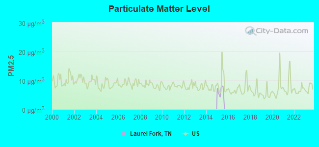
Ozone [ppb] level in 2022 was 28.7. This is about average. Closest monitor was 11.9 miles away from the city center.
| City: | 28.7 |
| U.S.: | 33.3 |
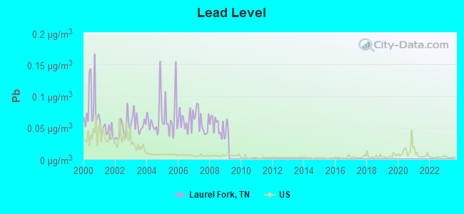
Lead (Pb) [µg/m3] level in 2008 was 0.0520. This is significantly worse than average. Closest monitor was 11.5 miles away from the city center.
| City: | 0.0520 |
| U.S.: | 0.0093 |
Tornado activity:
Laurel Fork-area historical tornado activity is significantly below Tennessee state average. It is 63% smaller than the overall U.S. average.
On 7/10/1980, a category F3 (max. wind speeds 158-206 mph) tornado 17.4 miles away from the Laurel Fork place center injured 12 people and caused between $50,000 and $500,000 in damages.
On 5/7/1998, a category F4 (max. wind speeds 207-260 mph) tornado 46.1 miles away from the place center injured 2 people and caused $1 million in damages.
Earthquake activity:
Laurel Fork-area historical earthquake activity is significantly above Tennessee state average. It is 15% greater than the overall U.S. average.On 8/9/2020 at 12:07:37, a magnitude 5.1 (5.1 MW, Depth: 4.7 mi, Class: Moderate, Intensity: VI - VII) earthquake occurred 54.1 miles away from the city center
On 8/23/2011 at 17:51:04, a magnitude 5.8 (5.8 MW, Depth: 3.7 mi) earthquake occurred 252.6 miles away from the city center
On 7/27/1980 at 18:52:21, a magnitude 5.2 (5.1 MB, 4.7 MS, 5.0 UK, 5.2 UK) earthquake occurred 169.8 miles away from the city center
On 11/30/1973 at 07:48:41, a magnitude 4.7 (4.7 MB, 4.6 ML, Class: Light, Intensity: IV - V) earthquake occurred 112.9 miles away from the city center
On 8/2/1974 at 08:52:09, a magnitude 4.9 (4.3 MB, 4.9 LG) earthquake occurred 168.3 miles away from the city center
On 11/23/2006 at 10:42:57, a magnitude 4.3 (4.3 MB) earthquake occurred 60.9 miles away from the city center
Magnitude types: regional Lg-wave magnitude (LG), body-wave magnitude (MB), local magnitude (ML), surface-wave magnitude (MS), moment magnitude (MW)
Natural disasters:
The number of natural disasters in Carter County (12) is smaller than the US average (15).Major Disasters (Presidential) Declared: 8
Emergencies Declared: 2
Causes of natural disasters: Floods: 8, Storms: 7, Heavy Rain: 1, Hurricane: 1, Landslide: 1, Mudslide: 1, Snowfall: 1, Tornado: 1, Winter Storm: 1, Other: 1 (Note: some incidents may be assigned to more than one category).
Hospitals and medical centers near Laurel Fork:
- ROAN HIGHLANDS NURSING CENTER (Nursing Home, about 7 miles away; ROAN MOUNTAIN, TN)
- ADVENTA HOSPICE, INC (Hospital, about 10 miles away; ELIZABETHTON, TN)
- PINE RIDGE CARE AND REHABILITATION CENTER (Nursing Home, about 11 miles away; ELIZABETHTON, TN)
- PINE RIDGE HEALTH CARE CTR (Nursing Home, about 11 miles away; ELIZABETHTON, TN)
- AMEDISYS HOME HEALTH CARE (Home Health Center, about 11 miles away; ELIZABETHTON, TN)
- IVY HALL NURSING HOME (Nursing Home, about 12 miles away; ELIZABETHTON, TN)
- HERMITAGE HEALTH CENTER (Nursing Home, about 13 miles away; ELIZABETHTON, TN)
Colleges/universities with over 2000 students nearest to Laurel Fork:
- East Tennessee State University (about 19 miles; Johnson City, TN; Full-time enrollment: 12,774)
- Appalachian State University (about 21 miles; Boone, NC; FT enrollment: 17,362)
- King University (about 23 miles; Bristol, TN; FT enrollment: 2,472)
- Northeast State Community College (about 26 miles; Blountville, TN; FT enrollment: 4,480)
- Tusculum College (about 42 miles; Greeneville, TN; FT enrollment: 2,070)
- Caldwell Community College and Technical Institute (about 43 miles; Hudson, NC; FT enrollment: 3,636)
- Western Piedmont Community College (about 43 miles; Morganton, NC; FT enrollment: 2,205)
Points of interest:
Notable locations in Laurel Fork: Don Nelan Appalachian Trail Shelter (A), Hanks Boat Dock (B), Clear Gap Shooting Range (C), Little Milligan Boating Site (D), Cardens Bluff Campground (E), YS Men Picnic Area (F), Rat Branch Boating Site (G), Dennis Cove Campground (H), Watauga Point Recreation Area (I), Watauga Lakeshores Resort (J), Lakeshore Dock (K), Fish Springs Dock (L), Dennis Cove (M), Cove Ridge Dock (N), Elk Mills - Poga Volunteer Fire Department (O). Display/hide their locations on the map
Churches in Laurel Fork include: Stout Hill Church (A), Sunrise View Church (B), Elk Mills Christian Church (C), Fish Springs Baptist Church (D), Stone Mountain Church (E), High Point Church (F), Walnut Mountain Church (G), Pleasant Hill Church (H), High Point Church (I). Display/hide their locations on the map
Cemeteries: Sugar Hollow Cemetery (1), Whaley Cemetery (2), Whitehead Cemetery (3), Lakeview Cemetery (4), Bennett Cemetery (5), Loyd Cemetery (6), Blackwell Cemetery (7). Display/hide their locations on the map
Reservoirs: Watauga Lake (A), Odom Trout Lake (B). Display/hide their locations on the map
Streams, rivers, and creeks: Black Branch (A), Little Laurel Fork (B), Leonard Branch (C), Lacy Trap Branch (D), Kite Branch (E), Sugar Hollow Branch (F), Elk River (G), Heaton Branch (H), Nowhere Branch (I). Display/hide their locations on the map
Parks in Laurel Fork include: Watauga Scenic Area (1), Laurel Fork Wildlife Management Area (2), Cherokee Wildlife Management Area (3), Watauga Point Recreational Area (4). Display/hide their locations on the map
| This place: | 2.4 people |
| Tennessee: | 2.5 people |
| This place: | 75.2% |
| Whole state: | 69.8% |
| This place: | 4.1% |
| Whole state: | 4.2% |
Likely homosexual households (counted as self-reported same-sex unmarried-partner households)
- Lesbian couples: 0.3% of all households
- Gay men: 0.0% of all households
| This place: | 22.9% |
| Whole state: | 13.5% |
| This place: | 7.0% |
| Whole state: | 5.8% |
For population 15 years and over in Laurel Fork:
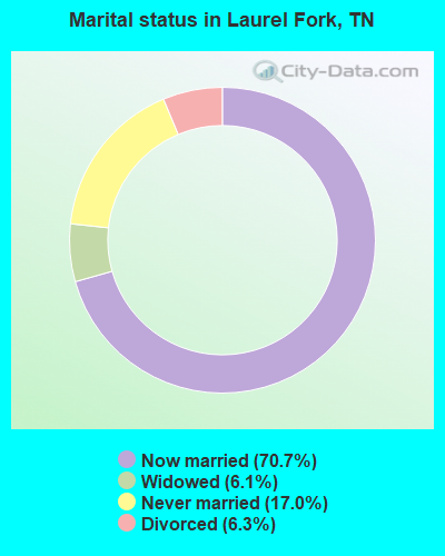
- Never married: 17.0%
- Now married: 70.7%
- Separated: 0.0%
- Widowed: 6.1%
- Divorced: 6.3%
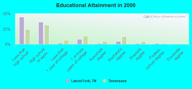
For population 25 years and over in Laurel Fork:
- High school or higher: 55.3%
- Bachelor's degree or higher: 7.6%
- Graduate or professional degree: 2.7%
- Unemployed: 9.7%
- Mean travel time to work (commute): 31.1 minutes
| Here: | 17.0 |
| Tennessee average: | 13.3 |
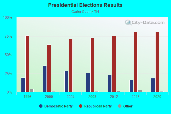
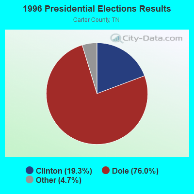
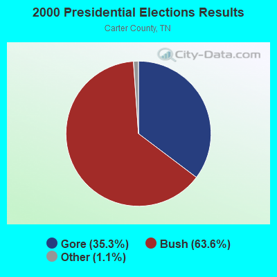
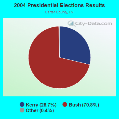
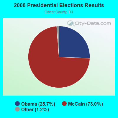
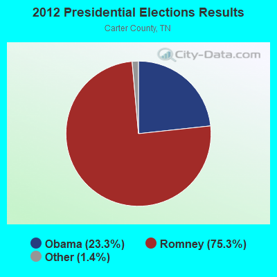
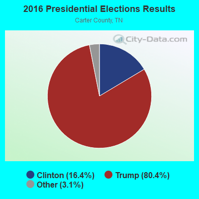
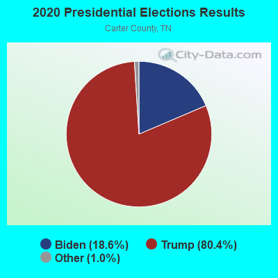
Graphs represent county-level data. Detailed 2008 Election Results
Religion statistics for Laurel Fork, TN (based on Carter County data)
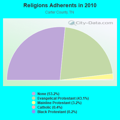
| Religion | Adherents | Congregations |
|---|---|---|
| Evangelical Protestant | 24,745 | 100 |
| Mainline Protestant | 1,817 | 13 |
| Catholic | 210 | 1 |
| Black Protestant | 118 | 1 |
| Other | 1 | 1 |
| None | 30,533 | - |
Food Environment Statistics:
| This county: | 1.35 / 10,000 pop. |
| Tennessee: | 1.99 / 10,000 pop. |
| Carter County: | 0.68 / 10,000 pop. |
| Tennessee: | 0.65 / 10,000 pop. |
| Carter County: | 4.90 / 10,000 pop. |
| Tennessee: | 5.16 / 10,000 pop. |
| This county: | 4.23 / 10,000 pop. |
| State: | 6.56 / 10,000 pop. |
| Here: | 11.9% |
| Tennessee: | 11.4% |
| Carter County: | 32.0% |
| State: | 30.2% |
| Carter County: | 11.2% |
| State: | 13.5% |
Strongest AM radio stations in Laurel Fork:
- WZAP (690 AM; 10 kW; BRISTOL, VA; Owner: RAM COMMUNICATIONS, INC.)
- WFGW (1010 AM; 50 kW; BLACK MOUNTAIN, NC; Owner: BLUE RIDGE BROADCASTING CORP.)
- WGOC (640 AM; 10 kW; BLOUNTVILLE, TN; Owner: CITADEL BROADCASTING COMPANY)
- WXIT (1200 AM; daytime; 10 kW; BLOWING ROCK, NC; Owner: RONDINARO BROADCASTING, INC.)
- WPWT (870 AM; daytime; 10 kW; COLONIAL HEIGHTS, TN; Owner: INFORMATION COMMUNICATIONS CORP.)
- WETB (790 AM; 5 kW; JOHNSON CITY, TN; Owner: MOUNTAIN SIGNALS, INC.)
- WHGG (1090 AM; daytime; 10 kW; KINGSPORT, TN; Owner: APPALACHIAN EDUCATIONAL COMMUNICATIO)
- WHKY (1290 AM; 50 kW; HICKORY, NC; Owner: LONG COMMUNICATIONS, LLC.)
- WKTP (1590 AM; 10 kW; JONESBOROUGH, TN; Owner: HOLSTON VALLEY BROADCASTING CORP.)
- WFHG (980 AM; 5 kW; BRISTOL, VA; Owner: BRISTOL BROADCASTING COMPANY, INC.)
- WJCW (910 AM; 5 kW; JOHNSON CITY, TN; Owner: CITADEL BROADCASTING COMPANY)
- WKSK (580 AM; 5 kW; W.JEFFERSON, NC; Owner: CADDELL BROADCASTING, INC.)
- WBCV (1550 AM; 5 kW; BRISTOL, TN; Owner: SUNSHINE BROADCASTERS, INC.)
Strongest FM radio stations in Laurel Fork:
- WHCB (91.5 FM; BRISTOL, TN; Owner: APPALACHIAN EDUC. COMMUNICATION CORP)
- WECR-FM (102.3 FM; BEECH MOUNTAIN, NC; Owner: RONDINARO BROADCASTING, INC)
- WETS-FM (89.5 FM; JOHNSON CITY, TN; Owner: EAST TENNESSEE STATE UNIVERSITY)
- WXBQ-FM (96.9 FM; BRISTOL, TN; Owner: BRISTOL BROADCASTING COMPANY, INC.)
- WPJO (99.3 FM; ELIZABETHTON, TN; Owner: BRISTOL BROADCASTING COMPANY, INC.)
- WCQR-FM (88.3 FM; KINGSPORT, TN; Owner: POSITIVE ALTERNATIVE RADIO, INC.)
- W214AP (90.7 FM; JOHNSON CITY, TN; Owner: THE MOODY BIBLE INSTITUTE OF CHICAGO)
- WZJS (100.7 FM; BANNER ELK, NC; Owner: HIGHLAND COMMUNICATIONS ASSOCIATES, LLC)
- WQUT (101.5 FM; JOHNSON CITY, TN; Owner: CITADEL BROADCASTING COMPANY)
- W285DG (104.9 FM; BOONE, NC; Owner: CITADEL BROADCASTING COMPANY)
- W225AA (92.9 FM; BOONE, NC; Owner: ISOTHERMAL COMMUNITY COLLEGE)
- WMIT (106.9 FM; BLACK MOUNTAIN, NC; Owner: BLUE RIDGE BROADCASTING CORPORATION)
- WNCW (88.7 FM; SPINDALE, NC; Owner: ISOTHERMAL COMMUNITY COLLEGE)
- WTFM (98.5 FM; KINGSPORT, TN; Owner: HOLSTON VALLEY BROADCASTING CORP.)
- WRZK (95.9 FM; COLONIAL HEIGHTS, TN; Owner: MURRAY COMMUNICATIONS)
- WKSF (99.9 FM; ASHEVILLE, NC; Owner: CAPSTAR TX LIMITED PARTNERSHIP)
- WAEZ (94.9 FM; GREENEVILLE, TN; Owner: BRISTOL BROADCASTING COMPANY, INC.)
- W267AN (101.3 FM; WILKESBORO, NC; Owner: TRIAD FAMILY NETWORK, INC.)
- WCSK (90.3 FM; KINGSPORT, TN; Owner: KINGSPORT CITY SCHOOLS BD. OF EDUC .)
- WMEV-FM (93.9 FM; MARION, VA; Owner: HOLSTON VALLEY BROADCASTING CORPORATION)
TV broadcast stations around Laurel Fork:
- WCYB-TV (Channel 5; BRISTOL, VA; Owner: APPALACHIAN BROADCASTING CORP.)
- WUNE-TV (Channel 17; LINVILLE, NC; Owner: UNIVERSITY OF NORTH CAROLINA)
- WASV-TV (Channel 62; ASHEVILLE, NC; Owner: MEDIA GENERAL BROADCASTING OF SOUTH CAROLINA HOLDINGS, INC.)
- WOPI-CA (Channel 9; BRISTOL,VA/KINGSPORT, TN; Owner: HOLSTON VALLEY BROADCASTING CORPORATION)
- WKPT-TV (Channel 19; KINGSPORT, TN; Owner: HOLSTON VALLEY BROADCASTING CORP.)
- WJHL-TV (Channel 11; JOHNSON CITY, TN; Owner: MEDIA GENERAL COMMUNICATIONS, INC.)
- WAPK-CA (Channel 36; BRISTOL,VA/KINGSPORT, TN; Owner: HOLSTON VALLEY BROADCASTING CORPORATION)
- W59AK (Channel 59; ZIONVILLE, NC; Owner: UNIVERSITY OF NORTH CAROLINA)
- W65DT (Channel 65; BOONE, NC; Owner: UNIVERSITY OF NORTH CAROLINA)
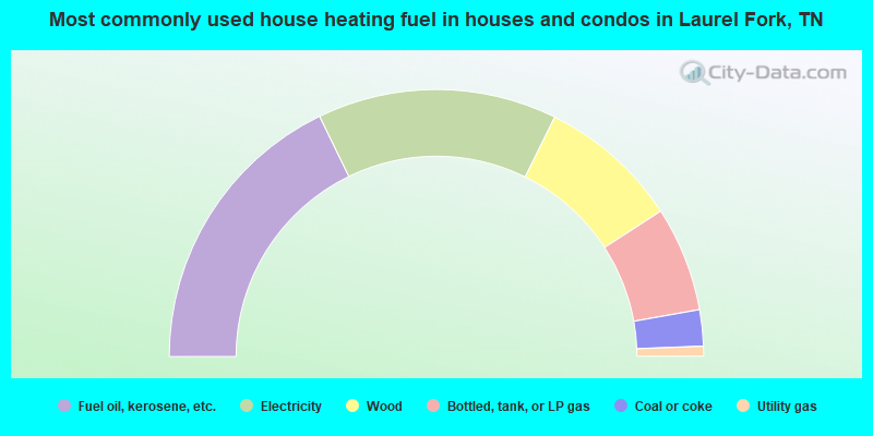
- 35.6%Fuel oil, kerosene, etc.
- 29.0%Electricity
- 17.1%Wood
- 12.7%Bottled, tank, or LP gas
- 4.4%Coal or coke
- 1.2%Utility gas
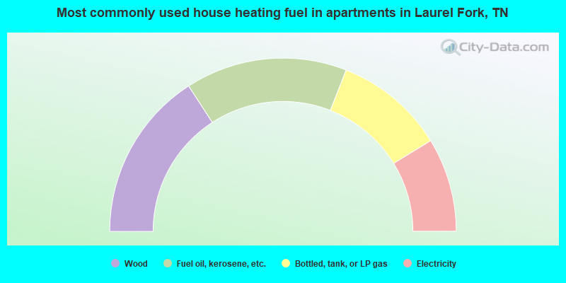
- 31.7%Wood
- 30.2%Fuel oil, kerosene, etc.
- 20.6%Bottled, tank, or LP gas
- 17.5%Electricity
Laurel Fork compared to Tennessee state average:
- Median household income below state average.
- Median house value below state average.
- Black race population percentage significantly below state average.
- Hispanic race population percentage significantly below state average.
- Foreign-born population percentage significantly below state average.
- Renting percentage significantly below state average.
- Length of stay since moving in significantly above state average.
- Number of rooms per house significantly below state average.
- House age significantly below state average.
- Percentage of population with a bachelor's degree or higher significantly below state average.
State forum archive:
- Tennessee Pages: 2 3 4 5 6 7 8 9 10 11 12 13 14 15 16 17 18 19 20 21 22 23 24 25 26 27 28 29 30 31 32
- Chattanooga Pages: 2 3 4 5 6 7 8 9 10 11 12 13
- Cookeville Pages: 2 3 4 5 6 7 8 9 10 11
- Kingsport - Johnson City - Bristol Pages: 2 3 4 5 6 7 8 9 10 11 12 13 14 15 16 17 18 19
- Knoxville Pages: 2 3 4 5 6 7 8 9 10 11 12 13 14 15 16 17 18 19 20 21 22 23 24 25 26 27 28 29 30 31
- Memphis Pages: 2 3 4 5 6 7 8 9 10 11 12 13 14 15 16 17 18 19 20
- Nashville Pages: 2 3 4 5 6 7 8 9 10 11 12 13 14 15 16 17 18 19 20 21 22 23 24 25 26 27 28 29 30 31 32 33 34 35 36 37 38 39 40 41 42 43 44 45 46 47 48 49 50 51 52 53 54 55 56 57