Little Sand Mountain, Georgia
Submit your own pictures of this place and show them to the world
- OSM Map
- General Map
- Google Map
- MSN Map

| Males: 1,071 | |
| Females: 1,084 |
| Median resident age: | 39.1 years |
| Georgia median age: | 33.4 years |
Zip code: 30747
| Little Sand Mountain: | $49,137 |
| GA: | $72,837 |
Estimated per capita income in 2022: $25,975 (it was $17,219 in 2000)
Little Sand Mountain CCD income, earnings, and wages data
Estimated median house or condo value in 2022: $146,293 (it was $81,200 in 2000)
| Little Sand Mountain: | $146,293 |
| GA: | $297,400 |
Mean prices in 2022: all housing units: $143,168; detached houses: $165,447; townhouses or other attached units: $250,432; mobile homes: $48,506
Little Sand Mountain, GA residents, houses, and apartments details
Detailed information about poverty and poor residents in Little Sand Mountain, GA
Compare current foreclosures near Little Sand Mountain, GA:
| Photo | Address | Area | Beds / Baths | Price | Details |
|---|---|---|---|---|---|

|
#1
Lewis Barrett Blvd NE
Rome, GA 30161
|
1,722 sq. feet
|
2 baths 3 beds |
show details | |

|
#2
Russell Hill Rd NW
Sugar Valley, GA 30746
|
1,655 sq. feet
|
2 baths 2 beds |
show details | |

|
#3
Woodridge Dr NW
Calhoun, GA 30701
|
4,883 sq. feet
|
4 baths 5 beds |
show details | |

|
#4
3rd Ave
La Fayette, GA 30728
|
1,196 sq. feet
|
2 baths 3 beds |
show details | |

|
#5
Baugh Mountain Rd NW
Sugar Valley, GA 30746
|
- sq. feet
|
2 baths 3 beds |
show details | |

|
#6
N Cherokee St
La Fayette, GA 30728
|
1,235 sq. feet
|
2 baths 3 beds |
show details | |

|
#7
Walton Creek Dr SW
Rome, GA 30165
|
1,830 sq. feet
|
1 baths 4 beds |
show details | |

|
#8
N Goat Rd NW
Resaca, GA 30735
|
900 sq. feet
|
1 baths 3 beds |
show details | |

|
#9
Martin Luther King Dr
Calhoun, GA 30701
|
986 sq. feet
|
2 baths 3 beds |
show details | |

|
#10
Berkshire Dr NE
Rome, GA 30161
|
1,694 sq. feet
|
2 baths - beds |
show details |
| Photo | Address | Area | Beds / Baths | Price | Details |
|---|---|---|---|---|---|

|
#11
Riverbend Rd SW
Plainville, GA 30733
|
1,832 sq. feet
|
2 baths 1 beds |
show details | |

|
#12
Rock Creek Rd SW
Calhoun, GA 30701
|
1,632 sq. feet
|
2 baths 3 beds |
show details | |

|
#13
Lavista Dr SW
Calhoun, GA 30701
|
1,687 sq. feet
|
2 baths 3 beds |
show details | |

|
#14
Cantrell Dr SW
Plainville, GA 30733
|
1,300 sq. feet
|
1 baths 3 beds |
show details | |

|
#15
Hunt Dr
Calhoun, GA 30701
|
2,046 sq. feet
|
1 baths 3 beds |
show details | |

|
#16
Court St
Calhoun, GA 30701
|
1,276 sq. feet
|
1 baths 2 beds |
show details | |

|
#17
E Line St
Calhoun, GA 30701
|
2,091 sq. feet
|
2 baths 3 beds |
show details | |

|
#18
Old Rome Dalton Rd NW
Calhoun, GA 30701
|
950 sq. feet
|
1 baths 2 beds |
show details | |

|
#19
College St
Calhoun, GA 30701
|
1,582 sq. feet
|
1 baths 3 beds |
show details | |

|
#20
Emory St SW
Calhoun, GA 30701
|
2,272 sq. feet
|
2 baths 3 beds |
show details |
| Photo | Address | Area | Beds / Baths | Price | Details |
|---|---|---|---|---|---|

|
#21
Flora Dr SW
Calhoun, GA 30701
|
1,920 sq. feet
|
2 baths 3 beds |
show details | |

|
#22
Pisgah Way
Calhoun, GA 30701
|
2,187 sq. feet
|
2 baths 4 beds |
show details | |

|
#23
Hillcrest Dr
Calhoun, GA 30701
|
2,617 sq. feet
|
2 baths 4 beds |
show details | |

|
#24
Moores Ferry Rd SW
Plainville, GA 30733
|
1,984 sq. feet
|
2 baths 3 beds |
show details | |

|
#25
Miller Ferry Rd SW
Calhoun, GA 30701
|
1,920 sq. feet
|
1 baths 3 beds |
show details | |

|
#26
Pioneer Dr NW
Calhoun, GA 30701
|
1,724 sq. feet
|
1 baths 3 beds |
show details | |

|
#27
Cherry Hill Cir
Calhoun, GA 30701
|
1,475 sq. feet
|
2 baths 3 beds |
show details | |

|
#28
Wilkins St NW
Rome, GA 30165
|
- sq. feet
|
1 baths 3 beds |
show details | |

|
#29
N Ridge Ct NW
Adairsville, GA 30103
|
1,204 sq. feet
|
2 baths 3 beds |
show details | |

|
#30
Mill Pond Ln
Calhoun, GA 30701
|
- sq. feet
|
3 baths 3 beds |
show details |
| Photo | Address | Area | Beds / Baths | Price | Details |
|---|---|---|---|---|---|

|
#31
Switch Connector Rd SW
Calhoun, GA 30701
|
1,870 sq. feet
|
1 baths 3 beds |
show details | |

|
#32
Hyde Rd NW
Resaca, GA 30735
|
1,271 sq. feet
|
1 baths 3 beds |
show details | |

|
#33
Circle Dr
Calhoun, GA 30701
|
1,135 sq. feet
|
2 baths 3 beds |
show details | |

|
#34
Lindsey Ct NE
Calhoun, GA 30701
|
1,288 sq. feet
|
2 baths 3 beds |
show details | |

|
#35
Jeep St
Calhoun, GA 30701
|
896 sq. feet
|
1 baths 2 beds |
show details | |

|
#36
Hunt Dr
Calhoun, GA 30701
|
2,389 sq. feet
|
2 baths 3 beds |
show details | |

|
#37
Ashford Pt NW
Adairsville, GA 30103
|
1,104 sq. feet
|
2 baths 3 beds |
show details | |

|
#38
Leek Rd SW
Adairsville, GA 30103
|
1,602 sq. feet
|
1 baths 3 beds |
show details | |

|
#39
Spring Valley Dr SW
Calhoun, GA 30701
|
991 sq. feet
|
1 baths 3 beds |
show details | |

|
#40
Russell Hill Rd NW
Sugar Valley, GA 30746
|
1,197 sq. feet
|
1 baths 3 beds |
show details |
| Photo | Address | Area | Beds / Baths | Price | Details |
|---|---|---|---|---|---|

|
#41
Riverside Dr NW
Calhoun, GA 30701
|
1,420 sq. feet
|
2 baths 3 beds |
show details | |

|
#42
Avalon Dr
Calhoun, GA 30701
|
1,622 sq. feet
|
2 baths 3 beds |
show details | |

|
#43
Bristol Pl SE
Calhoun, GA 30701
|
3,062 sq. feet
|
2 baths 3 beds |
show details | |

|
#44
Easy St
La Fayette, GA 30728
|
1,320 sq. feet
|
2 baths - beds |
show details | |

|
#45
E Indiana St
La Fayette, GA 30728
|
1,358 sq. feet
|
1 baths - beds |
show details | |

|
#46
Headrick Dr
La Fayette, GA 30728
|
1,254 sq. feet
|
2 baths - beds |
show details | |

|
#47
King St
La Fayette, GA 30728
|
896 sq. feet
|
1 baths - beds |
show details | |

|
#48
11th Ave
Menlo, GA 30731
|
1,688 sq. feet
|
1 baths - beds |
show details | |

|
#49
W Indiana St
La Fayette, GA 30728
|
1,230 sq. feet
|
1 baths - beds |
show details | |

|
Check over 1 million property listings on Foreclosure.com!
|
browse all offers | |||

- 1,87591.7%White alone
- 1467.1%Black alone
- 110.5%Two or more races
- 100.5%Hispanic
- 30.1%Other race alone

Races in Little Sand Mountain detailed stats: ancestries, foreign born residents, place of birth
 Recent articles from our blog. Our writers, many of them Ph.D. graduates or candidates, create easy-to-read articles on a wide variety of topics.
Current Local Time: EST time zone
Land area: 100.2 square miles.
Population density: 22 people per square mile (very low).

| Little Sand Mountain CCD: | 0.5% ($428) |
| Georgia: | 0.9% ($919) |
Nearest city with pop. 50,000+: Chattanooga, TN  (38.9 miles , pop. 155,554).
Nearest city with pop. 200,000+: Atlanta, GA (68.9 miles , pop. 416,474).
Nearest city with pop. 1,000,000+: Chicago, IL (526.0 miles , pop. 2,896,016).
Nearest cities:
), ), )Latitude: 34.48 N, Longitude: 85.23 W
Area code commonly used in this area: 706


| Here: | 3.5% |
| Georgia: | 2.9% |

- Textile mills & textile products (22.2%)
- Construction (12.7%)
- Health care (10.0%)
- Educational services (6.8%)
- Administrative & support & waste management services (3.4%)
- Transportation equipment (3.3%)
- Public administration (3.1%)

- Textile mills & textile products (25.4%)
- Construction (18.6%)
- Administrative & support & waste management services (5.9%)
- Public administration (4.5%)
- Transportation equipment (4.3%)
- Educational services (4.1%)
- Agriculture, forestry, fishing & hunting (3.9%)

- Health care (19.8%)
- Textile mills & textile products (17.7%)
- Educational services (10.5%)
- Finance & insurance (6.4%)
- Electrical equipment, appliances, components (5.1%)
- Construction (4.6%)
- Food & beverage stores (3.9%)

- Textile, apparel, and furnishings workers (9.5%)
- Material recording, scheduling, dispatching, and distributing workers (5.3%)
- Driver/sales workers and truck drivers (4.4%)
- Carpenters (4.4%)
- Sales representatives, services, wholesale and manufacturing (4.3%)
- Building and grounds cleaning and maintenance occupations (4.2%)
- Assemblers and fabricators (3.7%)

- Carpenters (7.6%)
- Driver/sales workers and truck drivers (7.6%)
- Textile, apparel, and furnishings workers (6.9%)
- Material recording, scheduling, dispatching, and distributing workers (6.7%)
- Building and grounds cleaning and maintenance occupations (5.9%)
- Electrical equipment mechanics and other installation, maintenance, and repair workers, including supervisors (5.0%)
- Laborers and material movers, hand (4.8%)

- Textile, apparel, and furnishings workers (13.1%)
- Secretaries and administrative assistants (8.2%)
- Assemblers and fabricators (7.2%)
- Sales representatives, services, wholesale and manufacturing (6.4%)
- Preschool, kindergarten, elementary, and middle school teachers (5.9%)
- Cashiers (5.1%)
- Nursing, psychiatric, and home health aides (4.9%)
Average climate in Little Sand Mountain, Georgia
Based on data reported by over 4,000 weather stations


(lower is better)

Air Quality Index (AQI) level in 2023 was 75.9. This is about average.
| City: | 75.9 |
| U.S.: | 72.6 |

Sulfur Dioxide (SO2) [ppb] level in 2016 was 1.61. This is about average. Closest monitor was 15.8 miles away from the city center.
| City: | 1.61 |
| U.S.: | 1.51 |

Ozone [ppb] level in 2022 was 21.5. This is significantly better than average. Closest monitor was 10.2 miles away from the city center.
| City: | 21.5 |
| U.S.: | 33.3 |

Particulate Matter (PM2.5) [µg/m3] level in 2023 was 9.39. This is about average. Closest monitor was 15.8 miles away from the city center.
| City: | 9.39 |
| U.S.: | 8.11 |

Lead (Pb) [µg/m3] level in 2008 was 0.00488. This is significantly better than average. Closest monitor was 15.5 miles away from the city center.
| City: | 0.00488 |
| U.S.: | 0.00931 |
Tornado activity:
Little Sand Mountain-area historical tornado activity is above Georgia state average. It is 85% greater than the overall U.S. average.
On 4/3/1974, a category F4 (max. wind speeds 207-260 mph) tornado 10.3 miles away from the Little Sand Mountain place center killed 9 people and injured 67 people and caused between $500,000 and $5,000,000 in damages.
On 5/19/1973, a category F4 tornado 25.1 miles away from the place center injured 19 people and caused between $500,000 and $5,000,000 in damages.
Earthquake activity:
Little Sand Mountain-area historical earthquake activity is significantly above Georgia state average. It is 101% greater than the overall U.S. average.On 4/29/2003 at 08:59:39, a magnitude 4.9 (4.4 MB, 4.6 MW, 4.9 LG, Class: Light, Intensity: IV - V) earthquake occurred 22.8 miles away from Little Sand Mountain center
On 4/29/2003 at 08:59:39, a magnitude 4.6 (4.6 MW, Depth: 12.3 mi) earthquake occurred 22.8 miles away from Little Sand Mountain center
On 11/30/1973 at 07:48:41, a magnitude 4.7 (4.7 MB, 4.6 ML) earthquake occurred 115.9 miles away from Little Sand Mountain center
On 1/18/1999 at 07:00:53, a magnitude 4.8 (4.8 MB, 4.0 LG, Depth: 0.6 mi) earthquake occurred 138.1 miles away from Little Sand Mountain center
On 8/2/1974 at 08:52:09, a magnitude 4.9 (4.3 MB, 4.9 LG) earthquake occurred 162.5 miles away from Little Sand Mountain center
On 12/12/2018 at 09:14:43, a magnitude 4.4 (4.4 MW, Depth: 4.9 mi) earthquake occurred 83.0 miles away from Little Sand Mountain center
Magnitude types: regional Lg-wave magnitude (LG), body-wave magnitude (MB), local magnitude (ML), moment magnitude (MW)
Natural disasters:
The number of natural disasters in Chattooga County (10) is smaller than the US average (15).Major Disasters (Presidential) Declared: 5
Emergencies Declared: 4
Causes of natural disasters: Floods: 3, Winter Storms: 3, Hurricanes: 2, Storms: 2, Tornadoes: 2, Drought: 1, Snowfall: 1, Other: 1 (Note: some incidents may be assigned to more than one category).
Hospitals and medical centers near Little Sand Mountain:
- HARBIN CLINIC SUMMERVILLE DIALYSIS CENTER (Dialysis Facility, about 6 miles away; SUMMERVILLE, GA)
- OAKVIEW HEALTH AND REHABILITATION (Nursing Home, about 7 miles away; SUMMERVILLE, GA)
- OAKVIEW NH (Nursing Home, about 7 miles away; SUMMERVILLE, GA)
- FORUM GROUP AT MOUNT BERRY NURSING AND REHAB CTR LLC (Nursing Home, about 14 miles away; ROME, GA)
- SUMMIT HEALTH AND REHABILITATION CENTER (Nursing Home, about 14 miles away; ROME, GA)
- NORTHWEST GA REG HOSP ICF-MR (Hospital, about 14 miles away; ROME, GA)
- NORTHWEST GEORGIA REGIONAL HOSPITAL (Hospital, about 14 miles away; ROME, GA)
Colleges/universities with over 2000 students nearest to Little Sand Mountain:
- Berry College (about 14 miles; Mount Berry, GA; Full-time enrollment: 2,102)
- Georgia Northwestern Technical College (about 19 miles; Rome, GA; FT enrollment: 4,629)
- Georgia Highlands College (about 22 miles; Rome, GA; FT enrollment: 4,071)
- Dalton State College (about 24 miles; Dalton, GA; FT enrollment: 3,846)
- Northeast Alabama Community College (about 40 miles; Rainsville, AL; FT enrollment: 2,409)
- The University of Tennessee-Chattanooga (about 40 miles; Chattanooga, TN; FT enrollment: 10,158)
- Southern Adventist University (about 41 miles; Collegedale, TN; FT enrollment: 2,898)
Points of interest:
Notable locations in Little Sand Mountain: New (A), Narrows Picnic Area (B), Camp Aquilla (C), Gore Area Volunteer Fire Department (D), Subligna Volunteer Fire Department (E). Display/hide their locations on the map
Churches in Little Sand Mountain include: Bethel Church (A), Fishers Chapel (B), Unity Church (C), Oak Hill Church (D), Pleasant Grove Baptist Church (E), Pleasant Hill Zion Church (F), South Carolina Campground Church (G), Poplar Springs Church (H), Little Sand Mountain Chapel Baptist Church (I). Display/hide their locations on the map
Cemeteries: Bethlehem Cemetery (1), Anderson Cemetery (2), Farmersville Cemetery (3), Mills Cemetery (4), Mount Joy Cemetery (5), Oak Hill Cemetery (6), Salmon Cemetery (7). Display/hide their locations on the map
Reservoirs: Selman Lake (A), Lake Tightsqueeze (B). Display/hide their locations on the map
Creeks: West Armuchee Creek (A), Storey Mill Creek (B), Selman Creek (C), Ruff Creek (D), Moss Creek (E), East Armuchee Creek (F), Cedar Creek (G). Display/hide their locations on the map
| This place: | 2.5 people |
| Georgia: | 2.6 people |
| This place: | 75.3% |
| Whole state: | 68.5% |
| This place: | 4.8% |
| Whole state: | 5.9% |
Likely homosexual households (counted as self-reported same-sex unmarried-partner households)
- Lesbian couples: 0.1% of all households
- Gay men: 0.3% of all households
| This place: | 14.4% |
| Whole state: | 13.0% |
| This place: | 5.5% |
| Whole state: | 6.1% |
For population 15 years and over in Little Sand Mountain:

- Never married: 19.3%
- Now married: 66.3%
- Separated: 1.5%
- Widowed: 6.9%
- Divorced: 7.5%
For population 25 years and over in Little Sand Mountain:
- High school or higher: 66.4%
- Bachelor's degree or higher: 10.0%
- Graduate or professional degree: 4.8%
- Unemployed: 4.9%
- Mean travel time to work (commute): 33.2 minutes


| Here: | 12.4 |
| Georgia average: | 13.3 |
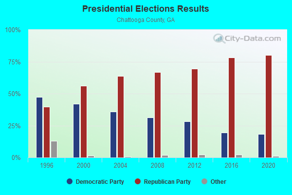
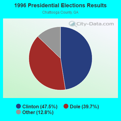
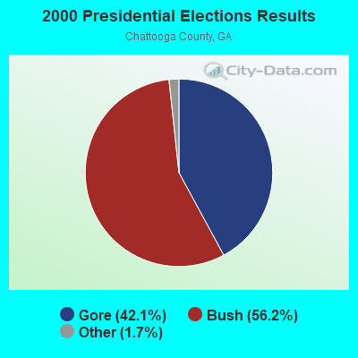
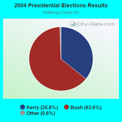
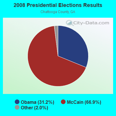

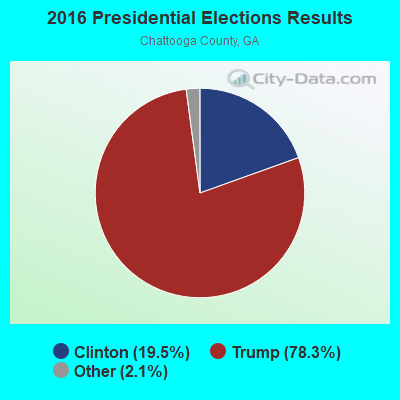
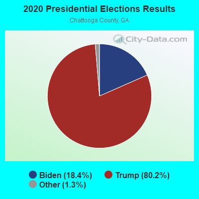
Graphs represent county-level data. Detailed 2008 Election Results
Religion statistics for Little Sand Mountain, GA (based on Chattooga County data)
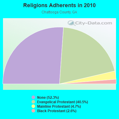
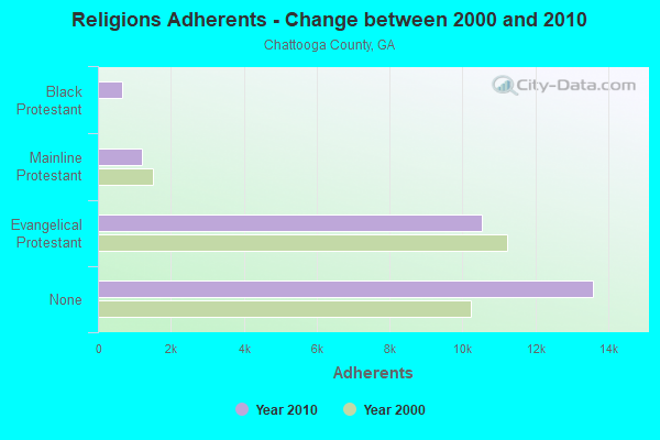
| Religion | Adherents | Congregations |
|---|---|---|
| Evangelical Protestant | 10,540 | 62 |
| Mainline Protestant | 1,210 | 12 |
| Black Protestant | 667 | 5 |
| Other | - | 1 |
| None | 13,598 | - |
Food Environment Statistics:
| This county: | 2.24 / 10,000 pop. |
| Georgia: | 1.91 / 10,000 pop. |
| This county: | 0.37 / 10,000 pop. |
| State: | 0.86 / 10,000 pop. |
| Chattooga County: | 5.97 / 10,000 pop. |
| Georgia: | 5.12 / 10,000 pop. |
| Chattooga County: | 4.10 / 10,000 pop. |
| Georgia: | 7.41 / 10,000 pop. |
| Chattooga County: | 11.2% |
| State: | 10.4% |
| This county: | 25.8% |
| Georgia: | 27.8% |
| This county: | 12.9% |
| Georgia: | 14.6% |
Strongest AM radio stations in Little Sand Mountain:
- WZQZ (1180 AM; daytime; 5 kW; TRION, GA; Owner: BARINOWSKI INVESTMENT COMPANY)
- WGTA (950 AM; 5 kW; SUMMERVILLE, GA; Owner: AZTECA COMMUNICATIONS, INC.)
- WFLI (1070 AM; 50 kW; LOOKOUT MOUNTAIN, TN; Owner: WFLI, INC.)
- WWAM (820 AM; daytime; 50 kW; JASPER, TN; Owner: SHELTON BROADCASTING SYSTEM)
- WFTD (1080 AM; daytime; 50 kW; MARIETTA, GA; Owner: PRIETO ENTERPRISES, INC.)
- WQRX (870 AM; daytime; 10 kW; VALLEY HEAD, AL; Owner: BARINOWSKI INVESTMENT COMPANY)
- WNSI (810 AM; 50 kW; JACKSONVILLE, AL; Owner: UNITED BROADCASTING NETWORK, INC.)
- WRGA (1470 AM; 5 kW; ROME, GA; Owner: MCDOUGALD BROADCASTING. CORP.)
- WKNG (1060 AM; daytime; 50 kW; TALLAPOOSA, GA; Owner: WKNG, INC.)
- WGST (640 AM; 50 kW; ATLANTA, GA; Owner: CITICASTERS LICENSES, L.P.)
- WCNN (680 AM; 50 kW; NORTH ATLANTA, GA; Owner: DICKEY BROADCASTING COMPANY)
- WMLB (1160 AM; 50 kW; EAST POINT, GA; Owner: ATLANTA AREA BROADCASTING, INC.)
- WSB (750 AM; 50 kW; ATLANTA, GA; Owner: CXR HOLDINGS, INC.)
Strongest FM radio stations in Little Sand Mountain:
- WATG (95.7 FM; TRION, GA; Owner: TTA BROADCASTING, INC)
- W215BA (90.9 FM; ROME, GA; Owner: PENSACOLA CHRISTIAN COLLEGE, INC.)
- WKCX (97.7 FM; ROME, GA; Owner: BRIAR CREEK BROADCASTING CORP.)
- WQTU (102.3 FM; ROME, GA; Owner: MCDOUGALD BROADCASTING CORPORATION)
- WBDX (102.7 FM; TRENTON, GA; Owner: PARTNERS FOR CHRISTIAN RADIO, INC.)
- W212AR (90.3 FM; LINDALE, GA; Owner: WAY-FM MEDIA GROUP, INC.)
- W234AG (94.7 FM; CHATSWORTH, GA; Owner: IMMANUEL BROADCASTING NETWORK, INC.)
- WMBW (88.9 FM; CHATTANOOGA, TN; Owner: THE MOODY BIBLE INSTITUTE OF CHICAGO)
- W214AS (90.7 FM; WALESKA, GA; Owner: CALVARY CHAPEL OF TWIN FALLS, INC.)
- W221AW (92.1 FM; NORTH CANTON, GA; Owner: IMMANUEL BROADCASTING NETWORK, INC.)
- WJCK (88.3 FM; PIEDMONT, AL; Owner: IMMANUEL BROADCASTING NETWORK, INC.)
- WRHY (105.9 FM; CENTRE, AL; Owner: WILLIAMS COMMUNICATIONS, INC.)
- W257AZ (99.3 FM; LOOKOUT MOUNTAIN, TN; Owner: CAPSTAR TX LIMITED PARTNERSHIP)
- WTSH-FM (107.1 FM; ROCKMART, GA; Owner: BROADCAST INVESTMENT ASSOCIATES, INC)
- WUSY (100.7 FM; CLEVELAND, TN; Owner: CAPSTAR TX LIMITED PARTNERSHIP)
- WCCV (91.7 FM; CARTERSVILLE, GA; Owner: IMMANUEL BROADCASTING NETWORK, INC.)
- WQMT (98.9 FM; CHATSWORTH, GA; Owner: CLEAR CHANNEL BROADCASTING LICENSES, INC.)
- WDEF-FM (92.3 FM; CHATTANOOGA, TN; Owner: JACKSON TELECASTERS, INC.)
- WSGC-FM (101.9 FM; RINGGOLD, GA; Owner: CLEAR CHANNEL BROADCASTING LICENSES, INC.)
- WAWL-FM (91.5 FM; RED BANK, TN; Owner: CHATTANOOGA STATE TECHNICAL COMMUNITY COLLEGE)
TV broadcast stations around Little Sand Mountain:
- WSUT-LP (Channel 21; SUMMERVILLE/TRION, GA; Owner: NORTH GEORGIA TELEVISION/NGTV)
- WFLI-TV (Channel 53; CLEVELAND, TN; Owner: CHATTANOOGA MEDIA HOLDINGS, L.L.C.)
- WPXA (Channel 14; ROME, GA; Owner: PAXSON ATLANTA LICENSE, INC.)
- WDNN-CA (Channel 43; DALTON, GA; Owner: NORTH GEORGIA TELEVISION)
- WLFW-LP (Channel 41; LAFAYETTE, GA; Owner: NORTH GEORGIA TELEVISION)

- 52.8%Bottled, tank, or LP gas
- 31.3%Electricity
- 12.6%Wood
- 1.9%Utility gas
- 1.4%No fuel used

- 48.7%Bottled, tank, or LP gas
- 40.2%Electricity
- 6.0%Fuel oil, kerosene, etc.
- 5.1%Utility gas
Little Sand Mountain compared to Georgia state average:
- Median house value below state average.
- Unemployed percentage significantly below state average.
- Black race population percentage significantly below state average.
- Hispanic race population percentage significantly below state average.
- Foreign-born population percentage significantly below state average.
- Renting percentage below state average.
- Length of stay since moving in significantly above state average.
- Number of rooms per house significantly below state average.
- House age significantly below state average.
- Number of college students below state average.
- Percentage of population with a bachelor's degree or higher significantly below state average.