Livermore, Colorado

Livermore
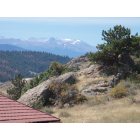
Livermore: Mummy Range as seen from Livermore, CO.
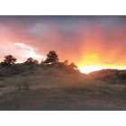
Livermore: Sunset at Hewlett Gulch, Livermore, CO.
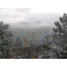
Livermore: Late Autumn Morning
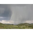
Livermore: The rain that never touched the ground
- add
your
Submit your own pictures of this place and show them to the world
- OSM Map
- General Map
- Google Map
- MSN Map

| Males: 2,728 | |
| Females: 2,642 |
| Median resident age: | 44.6 years |
| Colorado median age: | 34.3 years |
Zip code: 80545
| Livermore: | $94,190 |
| CO: | $89,302 |
Estimated per capita income in 2022: $57,078 (it was $28,988 in 2000)
Livermore CCD income, earnings, and wages data
Estimated median house or condo value in 2022: $668,914 (it was $208,200 in 2000)
| Livermore: | $668,914 |
| CO: | $531,100 |
Mean prices in 2022: all housing units: $616,153; detached houses: $667,268; townhouses or other attached units: $510,704; in 2-unit structures: $374,092; in 3-to-4-unit structures: $289,123; in 5-or-more-unit structures: $347,973; mobile homes: $80,465; occupied boats, rvs, vans, etc.: $9,202
Detailed information about poverty and poor residents in Livermore, CO


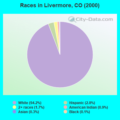
- 4,46194.2%White alone
- 1322.8%Hispanic
- 811.7%Two or more races
- 410.9%American Indian alone
- 140.3%Asian alone
- 70.1%Black alone
- 20.04%Native Hawaiian and Other
Pacific Islander alone
According to our research of Colorado and other state lists, there were 2 registered sex offenders living in Livermore, Colorado as of May 19, 2024.
The ratio of all residents to sex offenders in Livermore is 2,685 to 1.
The ratio of registered sex offenders to all residents in this city is much lower than the state average.
 Recent articles from our blog. Our writers, many of them Ph.D. graduates or candidates, create easy-to-read articles on a wide variety of topics.
Current Local Time: MST time zone
Elevation: 5884 feet
Land area: 1361.8 square miles.
Population density: 3.9 people per square mile (very low).
| Livermore CCD: | 0.5% ($1,049) |
| Colorado: | 0.7% ($1,132) |
Nearest city with pop. 50,000+: Fort Collins, CO  (31.6 miles , pop. 118,652).
Nearest city with pop. 200,000+: West Adams, CO (69.8 miles , pop. 259,628).
Nearest city with pop. 1,000,000+: Phoenix, AZ (613.9 miles , pop. 1,321,045).
Nearest cities:
), Latitude: 40.76 N, Longitude: 105.62 W
Area code commonly used in this area: 970

| Here: | 2.8% |
| Colorado: | 3.2% |
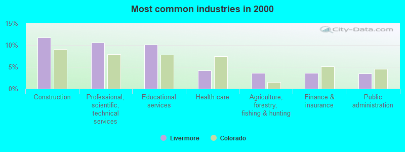
- Construction (11.8%)
- Professional, scientific, technical services (10.6%)
- Educational services (10.2%)
- Health care (4.2%)
- Agriculture, forestry, fishing & hunting (3.6%)
- Finance & insurance (3.5%)
- Public administration (3.5%)
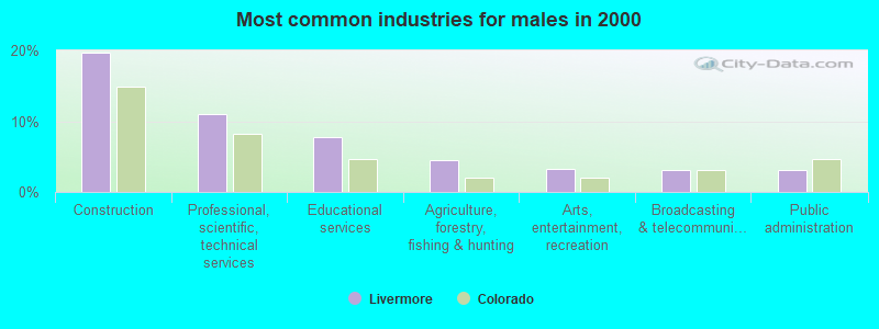
- Construction (19.7%)
- Professional, scientific, technical services (11.0%)
- Educational services (7.8%)
- Agriculture, forestry, fishing & hunting (4.4%)
- Arts, entertainment, recreation (3.2%)
- Broadcasting & telecommunications (3.1%)
- Public administration (3.1%)
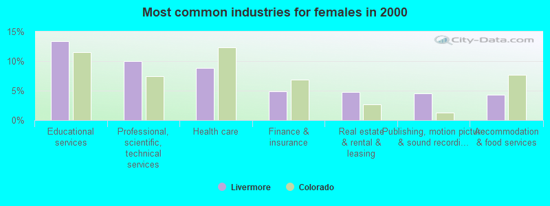
- Educational services (13.4%)
- Professional, scientific, technical services (10.0%)
- Health care (8.8%)
- Finance & insurance (4.9%)
- Real estate & rental & leasing (4.8%)
- Publishing, motion picture & sound recording industries (4.5%)
- Accommodation & food services (4.3%)
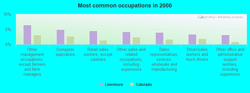
- Other management occupations, except farmers and farm managers (6.5%)
- Computer specialists (4.9%)
- Retail sales workers, except cashiers (4.5%)
- Other sales and related occupations, including supervisors (4.2%)
- Sales representatives, services, wholesale and manufacturing (4.0%)
- Driver/sales workers and truck drivers (3.4%)
- Other office and administrative support workers, including supervisors (3.2%)
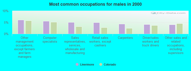
- Other management occupations, except farmers and farm managers (6.1%)
- Computer specialists (5.6%)
- Sales representatives, services, wholesale and manufacturing (5.0%)
- Retail sales workers, except cashiers (5.0%)
- Carpenters (4.3%)
- Driver/sales workers and truck drivers (4.1%)
- Other sales and related occupations, including supervisors (4.0%)
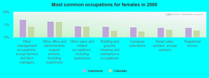
- Other management occupations, except farmers and farm managers (7.0%)
- Other office and administrative support workers, including supervisors (6.3%)
- Other sales and related occupations, including supervisors (4.5%)
- Building and grounds cleaning and maintenance occupations (4.2%)
- Computer specialists (4.0%)
- Retail sales workers, except cashiers (3.9%)
- Registered nurses (3.8%)
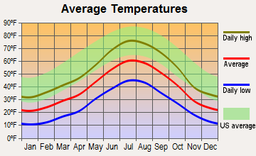
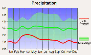
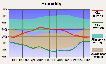
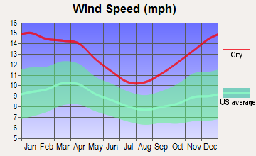
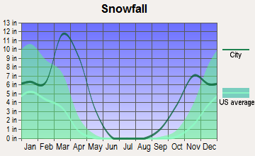
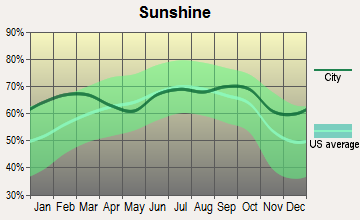
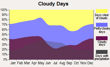
Average climate in Livermore, Colorado
Based on data reported by over 4,000 weather stations
Tornado activity:
Livermore-area historical tornado activity is slightly below Colorado state average. It is 45% smaller than the overall U.S. average.
On 4/23/1960, a category F3 (max. wind speeds 158-206 mph) tornado 27.7 miles away from the Livermore place center injured one person and caused between $5000 and $50,000 in damages.
On 5/22/2008, a category F2 (max. wind speeds 113-157 mph) tornado 21.9 miles away from the place center injured one person.
Earthquake activity:
Livermore-area historical earthquake activity is significantly above Colorado state average. It is 710% greater than the overall U.S. average.On 8/18/1959 at 06:37:13, a magnitude 7.7 (7.7 UK, Class: Major, Intensity: VIII - XII) earthquake occurred 367.0 miles away from Livermore center, causing $26,000,000 total damage
On 10/18/1984 at 15:30:23, a magnitude 5.5 (5.4 MB, 5.1 MS, 5.5 ML, Class: Moderate, Intensity: VI - VII) earthquake occurred 112.8 miles away from Livermore center
On 10/28/1983 at 14:06:06, a magnitude 7.3 (6.2 MB, 7.3 MS, 7.0 MW) earthquake occurred 476.3 miles away from the city center, causing 2 deaths (2 shaking deaths) and 3 injuries, causing $15,000,000 total damage
On 3/28/1975 at 02:31:05, a magnitude 6.2 (6.1 MB, 6.0 MS, 6.2 ML, Class: Strong, Intensity: VII - IX) earthquake occurred 366.1 miles away from Livermore center
On 2/3/1994 at 09:05:04, a magnitude 5.8 (5.4 MB, 5.5 MS, 5.8 MW, 5.8 ML, Depth: 4.9 mi) earthquake occurred 309.0 miles away from Livermore center
On 2/3/1995 at 15:26:10, a magnitude 5.3 (5.3 MB, 4.6 MS, Depth: 0.6 mi) earthquake occurred 216.1 miles away from the city center
Magnitude types: body-wave magnitude (MB), local magnitude (ML), surface-wave magnitude (MS), moment magnitude (MW)
Natural disasters:
The number of natural disasters in Larimer County (25) is a lot greater than the US average (15).Major Disasters (Presidential) Declared: 11
Emergencies Declared: 4
Causes of natural disasters: Fires: 11, Floods: 7, Storms: 7, Landslides: 3, Mudslides: 3, Flash Floods: 2, Snows: 2, Tornadoes: 2, Heavy Rain: 1, Hurricane: 1, Snowstorm: 1, Other: 1 (Note: some incidents may be assigned to more than one category).
Colleges/universities with over 2000 students nearest to Livermore:
- Colorado State University-Fort Collins (about 32 miles; Fort Collins, CO; Full-time enrollment: 25,099)
- University of Wyoming (about 38 miles; Laramie, WY; FT enrollment: 10,810)
- Wyotech-Laramie (about 40 miles; Laramie, WY; FT enrollment: 2,765)
- Laramie County Community College (about 50 miles; Cheyenne, WY; FT enrollment: 3,288)
- Aims Community College (about 52 miles; Greeley, CO; FT enrollment: 3,598)
- University of Northern Colorado (about 55 miles; Greeley, CO; FT enrollment: 11,469)
- University of Colorado Boulder (about 56 miles; Boulder, CO; FT enrollment: 28,328)
Public elementary/middle school in Livermore:
- LIVERMORE ELEMENTARY SCHOOL (Students: 74, Location: 360 RED FEATHER LAKES ROAD, Grades: KG-5)
Points of interest:
Notable locations in Livermore: North Fork Poudre Campground (A), North Lone Pine Trailhead (B), Bellvue State Fish Hatchery (C), Indian Meadows Rest Area (D), Poudre Valley REA (E), Bellaire Lake Campground (F), Red Feather Forest Service Facility (G), West Lake Campground (H), Dowdy Lake Campground (I), Creedmore Lakes Campground (J), Lost Lake Campground (K), Narrows Campground (L), Narrows Picnic Area (M), Stevens Gulch Campground (N), Stove Prairie Landing Campground (O), Upper Landing Campground (P), Eggers Rest Area (Q), Kelly Flats Campground (R), Mount McConnel Trailhead (S), Mountain Park Campground (T). Display/hide their locations on the map
Churches in Livermore include: Chapel in the Pines (A), Our Lady of the Lakes Church (B), Virginia Dale Church (C), Poudre Canyon Chapel (D). Display/hide their locations on the map
Cemeteries: Stoney Park Cemetery (1), Robinson Ranch Cemetery (2), Elliott Ranch Cemetery (3), Campbell Cemetery (4), Cabin Creek Grave (5), Boyd Family Cemetery (6), Black Mountain Ranch Cemetery (7). Display/hide their locations on the map
Lakes, reservoirs, and swamps: Pocahontas Lake (A), Camp Lake (B), Upper Camp Lake (C), Bench Lake (D), Rockhole Lake (E), Twin Crater Lakes (F), Carey Lake (G), Island Lake (H). Display/hide their locations on the map
Rivers and creeks: Link Creek (A), Pole Creek (B), Stuck Creek (C), Trollop Creek (D), McIntyre Creek (E), Bluebell Creek (F), Frenchwoman Creek (G), Granny Creek (H), Cow Creek (I). Display/hide their locations on the map
Drinking water stations with addresses in Livermore and their reported violations in the past:
GLACIER VIEW MEADOWS WSA (Population served: 395, Groundwater):Past health violations:WESTERN RIDGE RESTAURANT AND RESORT LLC (Population served: 100, Groundwater):Past monitoring violations:
- MCL, Average - Between APR-2012 and JUN-2012, Contaminant: Gross Alpha, Excl. Radon and U. Follow-up actions: St Public Notif requested (MAY-31-2012), St Violation/Reminder Notice (MAY-31-2012), St Compliance achieved (JUL-06-2012)
- MCL, Average - Between APR-2012 and JUN-2012, Contaminant: Combined Uranium. Follow-up actions: St Public Notif requested (MAY-31-2012), St Violation/Reminder Notice (MAY-31-2012), St Compliance achieved (JUL-06-2012), St Public Notif received (JUN-01-2013)
- MCL, Average - Between JAN-2012 and MAR-2012, Contaminant: Gross Alpha, Excl. Radon and U. Follow-up actions: St Public Notif requested (MAY-01-2012), St Violation/Reminder Notice (MAY-01-2012), St Compliance achieved (JUL-06-2012)
- MCL, Average - Between JAN-2012 and MAR-2012, Contaminant: Combined Uranium. Follow-up actions: St Public Notif requested (MAY-01-2012), St Violation/Reminder Notice (MAY-01-2012), St Compliance achieved (JUL-06-2012)
- MCL, Average - Between OCT-2011 and DEC-2011, Contaminant: Gross Alpha, Excl. Radon and U. Follow-up actions: St Public Notif requested (JAN-31-2012), St Violation/Reminder Notice (JAN-31-2012), St Compliance achieved (JUL-06-2012)
- MCL, Average - Between OCT-2011 and DEC-2011, Contaminant: Combined Uranium. Follow-up actions: St Public Notif requested (DEC-08-2011), St Violation/Reminder Notice (DEC-08-2011), St Public Notif received (MAY-24-2012), St Compliance achieved (JUL-06-2012)
- Monitoring and Reporting (DBP) - Between JAN-2011 and DEC-2013, Contaminant: TTHM. Follow-up actions: St Public Notif requested (NOV-13-2013), St Violation/Reminder Notice (NOV-13-2013), St Public Notif received (JUN-13-2014)
- Monitoring and Reporting (DBP) - Between JAN-2011 and DEC-2013, Contaminant: Total Haloacetic Acids (HAA5). Follow-up actions: St Public Notif requested (NOV-13-2013), St Violation/Reminder Notice (NOV-13-2013), St Public Notif received (JUN-13-2014)
- Monitoring and Reporting (DBP) - Between JAN-2010 and MAR-2010, Contaminant: Chlorine. Follow-up actions: St Public Notif requested (MAR-05-2010), St Violation/Reminder Notice (MAR-05-2010), St Compliance achieved (JUL-06-2010), St Public Notif received (MAY-13-2011)
- Follow-up Or Routine LCR Tap M/R - In JUL-01-2007, Contaminant: Lead and Copper Rule. Follow-up actions: St Public Notif requested (AUG-01-2007), St Violation/Reminder Notice (AUG-01-2007), St Public Notif received (APR-04-2008), St Compliance achieved (AUG-26-2008)
- Follow-up Or Routine LCR Tap M/R - In JAN-01-2003, Contaminant: Lead and Copper Rule. Follow-up actions: St Compliance achieved (AUG-26-2008)
- One routine major monitoring violation
- 33 regular monitoring violations
Past monitoring violations:
- One routine major monitoring violation
- One regular monitoring violation
| This place: | 2.2 people |
| Colorado: | 2.5 people |
| This place: | 70.0% |
| Whole state: | 63.9% |
| This place: | 5.7% |
| Whole state: | 6.5% |
Likely homosexual households (counted as self-reported same-sex unmarried-partner households)
- Lesbian couples: 0.9% of all households
- Gay men: 0.5% of all households
| This place: | 4.5% |
| Whole state: | 9.3% |
| This place: | 2.4% |
| Whole state: | 4.1% |
45 people in other nonhousehold living situations in 2000
21 people in other group homes in 2000
For population 15 years and over in Livermore:
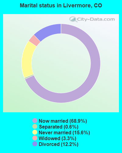
- Never married: 15.6%
- Now married: 68.9%
- Separated: 0.6%
- Widowed: 3.3%
- Divorced: 12.2%
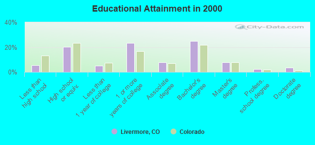
For population 25 years and over in Livermore:
- High school or higher: 94.6%
- Bachelor's degree or higher: 38.5%
- Graduate or professional degree: 13.7%
- Unemployed: 4.2%
- Mean travel time to work (commute): 35.4 minutes
| Here: | 9.7 |
| Colorado average: | 11.8 |
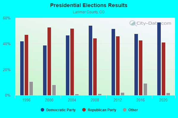
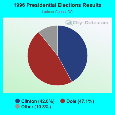
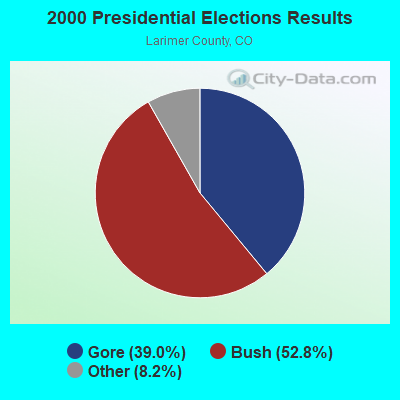
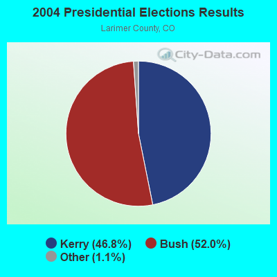
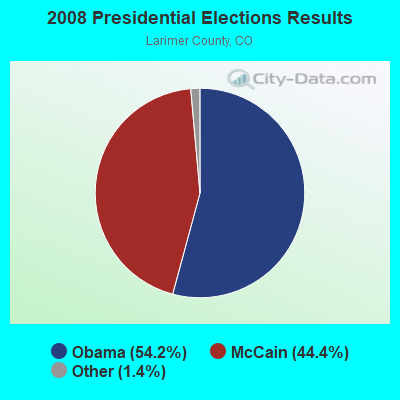
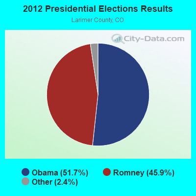
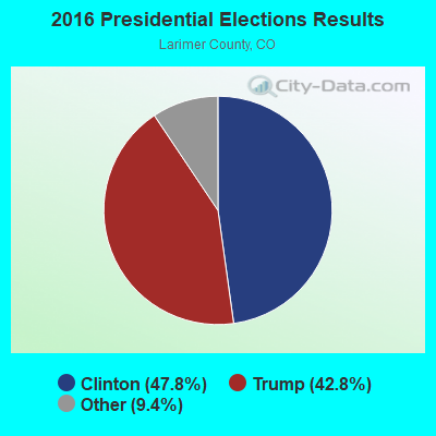
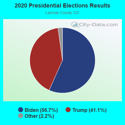
Graphs represent county-level data. Detailed 2008 Election Results
Religion statistics for Livermore, CO (based on Larimer County data)
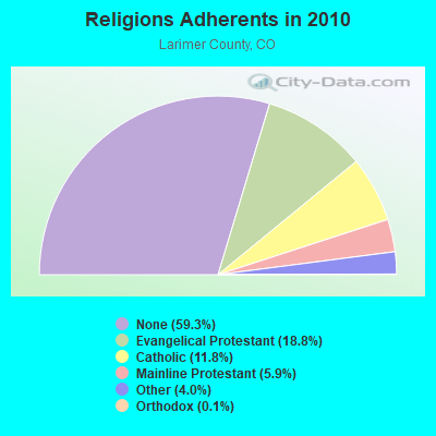
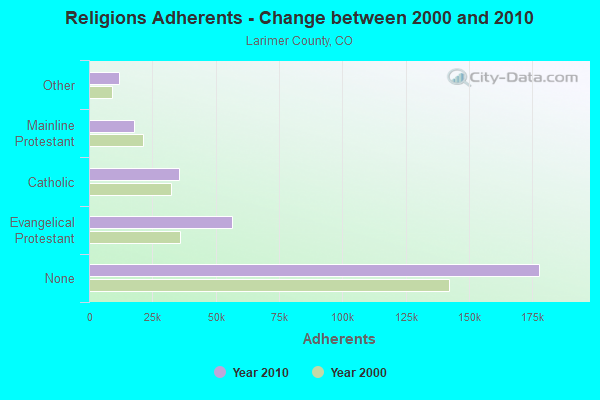
| Religion | Adherents | Congregations |
|---|---|---|
| Evangelical Protestant | 56,390 | 138 |
| Catholic | 35,495 | 7 |
| Mainline Protestant | 17,721 | 38 |
| Other | 11,909 | 46 |
| Orthodox | 370 | 2 |
| None | 177,745 | - |
Food Environment Statistics:
| Larimer County: | 0.94 / 10,000 pop. |
| State: | 1.50 / 10,000 pop. |
| Larimer County: | 0.14 / 10,000 pop. |
| Colorado: | 0.15 / 10,000 pop. |
| Larimer County: | 0.21 / 10,000 pop. |
| State: | 0.45 / 10,000 pop. |
| Here: | 3.35 / 10,000 pop. |
| Colorado: | 3.13 / 10,000 pop. |
| Larimer County: | 8.72 / 10,000 pop. |
| Colorado: | 8.99 / 10,000 pop. |
| Here: | 4.5% |
| State: | 5.3% |
| Larimer County: | 16.5% |
| Colorado: | 18.4% |
| This county: | 10.6% |
| Colorado: | 9.6% |
10.04% of this county's 2021 resident taxpayers lived in other counties in 2020 ($73,979 average adjusted gross income)
| Here: | 10.04% |
| Colorado average: | 11.28% |
0.02% of residents moved from foreign countries ($109 average AGI)
Larimer County: 0.02% Colorado average: 0.05%
Top counties from which taxpayers relocated into this county between 2020 and 2021:
| from Weld County, CO | |
| from Boulder County, CO | |
| from Denver County, CO |
9.59% of this county's 2020 resident taxpayers moved to other counties in 2021 ($66,015 average adjusted gross income)
| Here: | 9.59% |
| Colorado average: | 11.05% |
0.02% of residents moved to foreign countries ($106 average AGI)
Larimer County: 0.02% Colorado average: 0.03%
Top counties to which taxpayers relocated from this county between 2020 and 2021:
| to Weld County, CO | |
| to Denver County, CO | |
| to Boulder County, CO |
Strongest AM radio stations in Livermore:
- KKZN (760 AM; 50 kW; THORNTON, CO; Owner: JACOR BROADCASTING OF COLORADO, INC.)
- KLTT (670 AM; 50 kW; COMMERCE CITY, CO; Owner: KLZ RADIO, INC.)
- KLMO (1060 AM; 30 kW; LONGMONT, CO; Owner: PILGRIM COMMUNICATIONS, INC.)
- KCOL (600 AM; 5 kW; WELLINGTON, CO; Owner: JACOR BROADCASTING OF COLORADO, INC.)
- KKHI (1210 AM; 10 kW; LARAMIE, WY; Owner: LARAMIE MOUNTAIN BROADCASTING, L.L.C.)
- KOA (850 AM; 50 kW; DENVER, CO; Owner: JACOR BROADCASTING OF COLORADO, INC.)
- KGAB (650 AM; 8 kW; ORCHARD VALLEY, WY; Owner: CITICASTERS LICENSES, L.P.)
- KMXA (1090 AM; 50 kW; AURORA, CO; Owner: ENTRAVISION HOLDINGS, LLC)
- KIIX (1410 AM; 5 kW; FORT COLLINS, CO; Owner: JACOR BROADCASTING OF COLORADO, INC.)
- KHNC (1360 AM; 10 kW; JOHNSTOWN, CO; Owner: DONALD A. AND SHARON E. WIEDEMAN)
- KIMB (1260 AM; 50 kW; KIMBALL, NE; Owner: G & L INVESTMENTS, LLC)
- KJJL (1370 AM; 10 kW; CHEYENNE, WY; Owner: CHRISTUS BROADCASTING, INC.)
- KOWB (1290 AM; 5 kW; LARAMIE, WY; Owner: CLEAR CHANNEL BROADCASTING LICENSES, INC.)
Strongest FM radio stations in Livermore:
- KARS-FM (102.9 FM; LARAMIE, WY; Owner: AGM-NEVADA LLC)
- KRKS-FM (94.7 FM; LAFAYETTE, CO; Owner: SALEM MEDIA OF COLORADO, INC)
- KRQU (104.5 FM; LARAMIE, WY; Owner: LARAMIE MOUNTAIN BROADCASTING, LLC)
- K298AE (107.5 FM; LARAMIE, WY; Owner: WESTERN INSPIRATIONAL BROADCASTERS, INC)
- KXDC (102.1 FM; ESTES PARK, CO; Owner: HIGH PEAK BROADCASTING, L.L.C.)
- KUWR (91.9 FM; LARAMIE, WY; Owner: UNIVERSITY OF WYOMING)
- KIMX (105.5 FM; LARAMIE, WY; Owner: LARAMIE MOUNTAIN BROADCASTING, L.L.C.)
- K206DB (89.1 FM; FORT COLLINS, ETC., CO; Owner: BOULDER COMMUNITY B/CAST ASSOC., INC)
- KCGY (95.1 FM; LARAMIE, WY; Owner: CLEAR CHANNEL BROADCASTING LICENSES, INC.)
- KHAT (96.7 FM; LARAMIE, WY; Owner: RULE COMMUNICATIONS)
- K296BO (107.1 FM; LARAMIE, WY; Owner: LARAMIE PLAINS ANT. TV ASSOC. INC.)
- KQLF (97.9 FM; CHEYENNE, WY; Owner: CITICASTERS LICENSES, L.P.)
- KCSU-FM (90.5 FM; FORT COLLINS, CO; Owner: BOARD OF GOVERNORS OF THE COLORADO STATE UNIVERSITY SYSTEM)
- KKQZ (94.3 FM; WELLINGTON, CO; Owner: REGENT BROADCASTING OF FT. COLLINS, INC.)
- KPAW (107.9 FM; FORT COLLINS, CO; Owner: JACOR BROADCASTING OF COLORADO, INC.)
TV broadcast stations around Livermore:
- K57AA (Channel 57; ESTES PARK, CO; Owner: SYNCOM MEDIA GROUP, INC.)
- K48CG (Channel 48; LOVELAND, CO; Owner: TRINITY BROADCASTING NETWORK)
FCC Registered Cell Phone Towers:
1- 1.52 Mi E And 0.54 Mi S Of The Intersection Of Us Rte 287 And Red Feather Lakes (Lat: 40.786639 Lon: -105.187194), Call Sign: KNKA714
Assigned Frequencies: 880.020 MHz, 891.510 MHz, 835.020 MHz, 846.510 MHzGrant Date: 12/19/2017, Expiration Date: 01/22/2028, Certifier: Gregory M RomanoRegistrant: Verizon, 1300 I St Nw - Suite 500 East, Washington, DC 20005, Phone: (202) 515-2453, Email:
FCC Registered Antenna Towers:
4- Edward G Roach, 11585 North Highway 287 (Lat: 40.730444 Lon: -105.175806), Type: 51.8, Overall height: 48.8 m, Registrant: None
- Edward G Roach, 11585 North Highway 287 (Lat: 40.730444 Lon: -105.175806), Type: 51.8, Overall height: 48.8 m, Registrant: Sba Towers, Inc., Eroach@sbasite.Com, , Boca -Raton, Phone: (561) 995-7670
- Edward G Roach, 11585 North Highway 287 (Lat: 40.730444 Lon: -105.175806), Type: 51.8, Overall height: 48.8 m, Registrant: None
- Boidhi Gerfen, 98 Eiger Rd (Lat: 40.733306 Lon: -105.395889), Type: 57.9, Structure height: 08069 m, Overall height: 54.9 m, Registrant: Pygmy Farm Inc, Accounts@pygmyfarm.Com, , Liver-more, Phone: (970) 482-4401
FCC Registered Broadcast Land Mobile Towers:
2- 16230 N Hwy 287 (Lat: 40.781917 Lon: -105.169694), Type: Building, Structure height: 21 m, Overall height: 27 m, Call Sign: KNBU210,
Assigned Frequencies: 154.490 MHz, Grant Date: 03/30/2004, Expiration Date: 04/21/2014, Cancellation Date: 06/21/2014, Registrant: Complete Wireless Technologies, 621-C Innovation Circle, Windsor, CO 80550, Phone: (970) 686-7530, Fax: (970) 686-7746, Email:
- 785 Gordon Creek Lane (Lat: 40.734306 Lon: -105.317500), Type: Pipe, Structure height: 2 m, Call Sign: WQRG247,
Assigned Frequencies: 4950.00 MHz, Grant Date: 02/16/2023, Expiration Date: 05/07/2033, Certifier: David S Rowe, Registrant: Larimer County Technical Communications, 2501 Midpoint Dr, Fort Collins, CO 80525, Phone: (970) 498-5398, Fax: (970) 498-9203, Email:
FCC Registered Microwave Towers:
3- LIVERMORE, 16238 N Highway 287 (Lat: 40.787389 Lon: -105.186889), Type: Mast, Structure height: 57.9 m, Overall height: 60.6 m, Call Sign: WQLX713,
Assigned Frequencies: 11345.0 MHz, Grant Date: 04/14/2020, Expiration Date: 05/20/2030, Certifier: Gregory M Romano, Registrant: Verizon Wireless, 5055 North Point Pkwy, Np2ne Network Engineering, Alpharetta, GA 30022, Phone: (770) 797-1070, Email:
- ATC EXISTING, 28382 Us 287 Dup (Lat: 40.930167 Lon: -105.337611), Type: Ltower, Structure height: 54.9 m, Call Sign: WRJC325,
Assigned Frequencies: 6034.15 MHz, 6123.10 MHz, 5974.85 MHz, 6123.10 MHz, Grant Date: 08/04/2020, Expiration Date: 08/04/2030, Certifier: Kevin Hetrick, Registrant: At&t Services, Inc., 208 S Akard St, 20f, Dallas, TX 75202, Phone: (855) 699-7073, Email:
- AFO, 2154 Co Rd 43f N (Lat: 40.997222 Lon: -105.359000), Type: Gtower, Structure height: 36.6 m, Call Sign: WRPW851,
Assigned Frequencies: 11245.0 MHz, 11325.0 MHz, 11245.0 MHz, 11325.0 MHz, 11245.0 MHz, 11325.0 MHz, 11245.0 MHz, 11325.0 MHz, 11245.0 MHz, 11325.0 MHz... (+14 more), Grant Date: 03/28/2022, Expiration Date: 03/28/2032, Certifier: Brent M Keele, Registrant: Micronet Communications, Inc., 812 Lexington Dr, Plano, TX 75075, Phone: (972) 422-7200, Email:
FCC Registered Amateur Radio Licenses:
39 (See the full list of FCC Registered Amateur Radio Licenses in Livermore)FAA Registered Aircraft:
3- Aircraft: MALM WILLIAM C KITFOX IV (Category: Land, Seats: 2, Weight: Up to 12,499 Pounds), Engine: BOMBARDIER ROTAX (ALL) (Reciprocating)
N-Number: 106WM, N106WM, N-106WM, Serial Number: 1405, Year manufactured: 1992, Airworthiness Date: 08/20/1992, Certificate Issue Date: 07/07/1992
Registrant (Individual): William Malm, 205 N Rim Rd, Livermore, CO 80536 - Aircraft: SCHEMPP-HIRTH K G MINI-NIMBUS C (Category: Land, Weight: Up to 12,499 Pounds), Engine: None
N-Number: 8FZ, N8FZ, N-8FZ, Serial Number: 118, Year manufactured: 1979, Airworthiness Date: 05/09/1980, Certificate Issue Date: 10/23/2018
Registrant (Individual): Kelly E Fox, 105 Arikaree Peak Dr, Livermore, CO 80536 - Aircraft: SWANSON RICHARD E RV7A (Category: Land, Seats: 2, Weight: Up to 12,499 Pounds), Engine: AEROSPORT O-360-A1A (180 HP) (Reciprocating)
N-Number: 926TM, N926TM, N-926TM, Serial Number: 72184, Year manufactured: 2008, Airworthiness Date: 09/04/2008, Certificate Issue Date: 06/23/2008
Registrant (Individual): Richard E Swanson, 728 Guardian Peak Dr, Livermore, CO 80536
2003 - 2018 National Fire Incident Reporting System (NFIRS) incidents
- Fire incident types reported to NFIRS in Livermore, CO
- 27465.1%Outside Fires
- 7618.1%Structure Fires
- 5112.1%Mobile Property/Vehicle Fires
- 204.8%Other
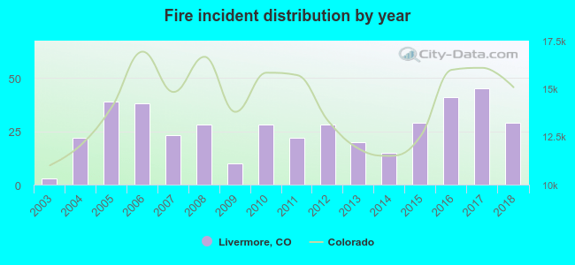 According to the data from the years 2003 - 2018 the average number of fires per year is 26. The highest number of fires - 45 took place in 2017, and the least - 3 in 2003. The data has a rising trend.
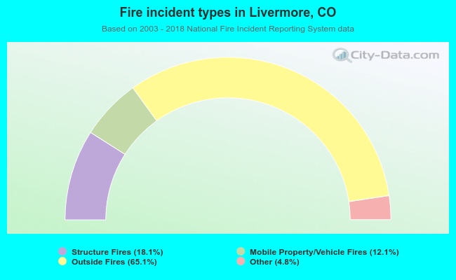 When looking into fire subcategories, the most incidents belonged to: Outside Fires (65.1%), and Structure Fires (18.1%).
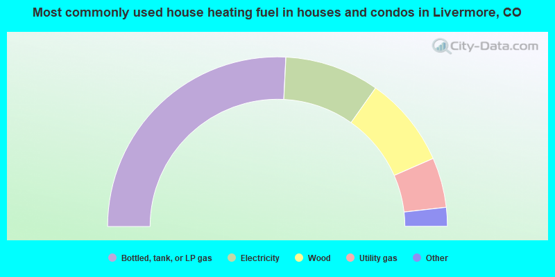
- 51.6%Bottled, tank, or LP gas
- 18.0%Electricity
- 17.3%Wood
- 9.5%Utility gas
- 2.6%Solar energy
- 0.5%Other fuel
- 0.5%Coal or coke
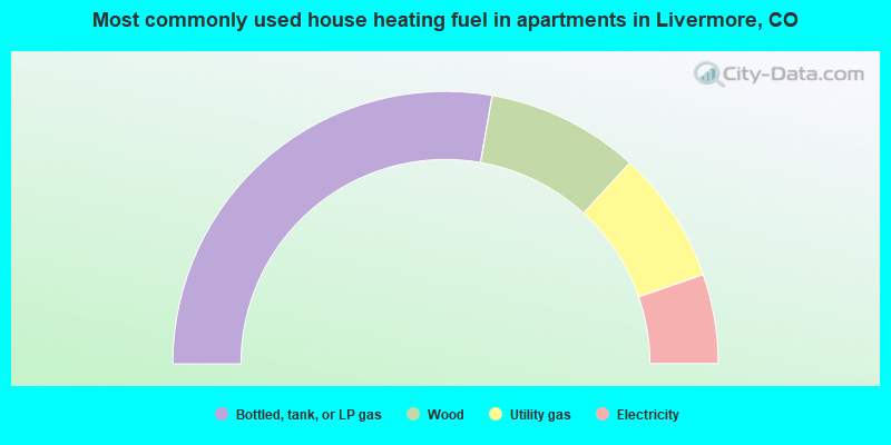
- 55.5%Bottled, tank, or LP gas
- 18.1%Wood
- 15.8%Utility gas
- 10.6%Electricity
Livermore compared to Colorado state average:
- Unemployed percentage significantly below state average.
- Black race population percentage significantly below state average.
- Hispanic race population percentage significantly below state average.
- Median age above state average.
- Foreign-born population percentage significantly below state average.
- Renting percentage significantly below state average.
- Length of stay since moving in significantly above state average.
- Number of rooms per house significantly below state average.
- House age significantly below state average.
Livermore on our top lists:
- #4 on the list of "Top 101 cities with largest percentage of males in industries: farm supplies merchant wholesalers (population 5,000+)"
- #5 on the list of "Top 101 cities with largest percentage of males in occupations: life and physical scientists (population 5,000+)"
- #6 on the list of "Top 101 cities with largest percentage of females in industries: publishing, and motion picture and sound recording industries (population 5,000+)"
- #7 on the list of "Top 101 cities with largest percentage of females in occupations: driver/sales workers and truck drivers (population 5,000+)"
- #8 on the list of "Top 101 cities with largest percentage of females in occupations: media and communication equipment workers (population 5,000+)"
- #18 on the list of "Top 101 cities with largest percentage of females in occupations: motor vehicle operators except bus and truck drivers (population 5,000+)"
- #21 on the list of "Top 101 cities with largest percentage of females in industries: repair and maintenance (population 5,000+)"
- #24 on the list of "Top 101 cities with largest percentage of females in industries: beverage and tobacco products (population 5,000+)"
- #28 on the list of "Top 101 cities with largest percentage of females in industries: sewing, needlework, and piece goods stores (population 5,000+)"
- #31 on the list of "Top 101 cities with largest percentage of females in industries: used merchandise, gift, novelty, and souvenir, and other miscellaneous stores (population 5,000+)"
- #31 on the list of "Top 100 cities with largest land areas (pop. 5,000+)"
- #33 on the list of "Top 101 cities with largest percentage of females in occupations: other management occupations except farmers and farm managers (population 5,000+)"
- #33 on the list of "Top 101 cities with largest percentage of females in industries: truck transportation (population 5,000+)"
- #35 on the list of "Top 101 cities with largest percentage of males in occupations: retail sales workers except cashiers (population 5,000+)"
- #38 on the list of "Top 101 cities with largest percentage of males in industries: electrical and electronic goods merchant wholesalers (population 5,000+)"
- #40 on the list of "Top 101 cities with largest percentage of males in industries: other direct selling establishments (population 5,000+)"
- #47 on the list of "Top 101 cities with largest percentage of females in industries: u. s. postal service (population 5,000+)"
- #50 on the list of "Top 101 cities with largest percentage of females in industries: private households (population 5,000+)"
- #53 on the list of "Top 101 cities with largest percentage of males in industries: religious, grantmaking, civic, professional, and similar organizations (population 5,000+)"
- #57 on the list of "Top 101 cities with largest percentage of males in industries: building material and garden equipment and supplies dealers (population 5,000+)"
- #2 on the list of "Top 101 counties with the largest decrease in the number of infant deaths per 1000 residents 2000-2006 to 2007-2013 (pop. 50,000+)"
- #3 on the list of "Top 101 counties with the lowest number of infant deaths per 1000 residents 2007-2013 (pop. 50,000+)"
- #13 on the list of "Top 101 counties with the lowest average weight of females"
- #14 on the list of "Top 101 counties with the highest percentage of residents that exercised in the past month"
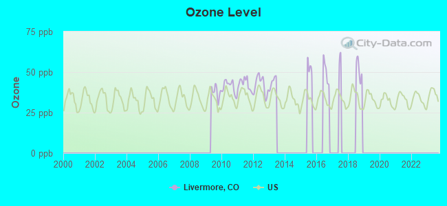
- #14 on the list of "Top 101 counties with the highest Ozone (1-hour) air pollution readings in 2012 (ppm)"

|
|
Total of 22 patent applications in 2008-2024.