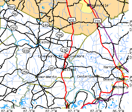
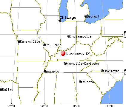
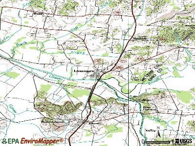
Livermore, Kentucky

Livermore: Mirror image of the Green River Bridge
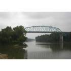
Livermore: Green River Bridge from Livermore to Island
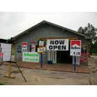
Livermore: New Store Opened In Livermore

Livermore: Flower Garden
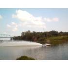
Livermore: Livermore Dragboat races - 2006
- add
your
Submit your own pictures of this city and show them to the world
- OSM Map
- General Map
- Google Map
- MSN Map
Population change since 2000: -18.4%
 |
| Males: 543 | |
| Females: 667 |
| Median resident age: | 40.3 years |
| Kentucky median age: | 39.4 years |
Zip codes: 42352.
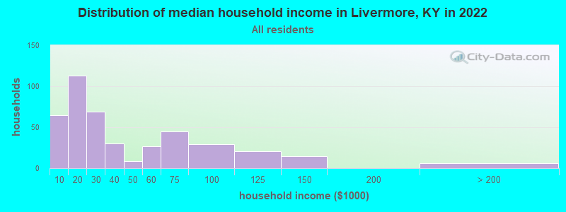
| Livermore: | $23,330 |
| KY: | $59,341 |
Estimated per capita income in 2022: $25,669 (it was $15,049 in 2000)
Livermore city income, earnings, and wages data
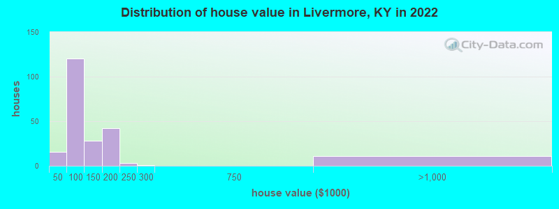
Estimated median house or condo value in 2022: $99,148 (it was $43,200 in 2000)
| Livermore: | $99,148 |
| KY: | $196,300 |
Mean prices in 2022: all housing units: $140,177; detached houses: $146,383; mobile homes: $31,925
Median gross rent in 2022: $318.
(27.5% for White Non-Hispanic residents, 100.0% for Hispanic or Latino residents, 30.8% for two or more races residents)
Detailed information about poverty and poor residents in Livermore, KY

Compare current foreclosures near Livermore, KY:
| Photo | Address | Area | Beds / Baths | Price | Details |
|---|---|---|---|---|---|

|
#1
Sycamore Dr
Livermore, KY 42352
|
2,376 sq. feet
|
2 baths 3 beds |
show details | |

|
#2
Us Highway 62 W
Rockport, KY 42369
|
1,225 sq. feet
|
1 baths 3 beds |
show details | |

|
#3
Stringtown Rd
Sacramento, KY 42372
|
2,068 sq. feet
|
2 baths 4 beds |
show details | |

|
#4
W Everly Brothers Blvd
Central City, KY 42330
|
1,453 sq. feet
|
2 baths 3 beds |
show details | |

|
#5
Willow Glen Rd
Central City, KY 42330
|
1,100 sq. feet
|
1 baths 3 beds |
show details | |

|
#6
Masonville Habit Rd
Philpot, KY 42366
|
1,359 sq. feet
|
1 baths 3 beds |
show details | |

|
#7
Garden Dr
Utica, KY 42376
|
1,218 sq. feet
|
1 baths 3 beds |
show details | |

|
#8
Richland Rd
Calhoun, KY 42327
|
756 sq. feet
|
1 baths 3 beds |
show details | |

|
#9
Old State Rd
Philpot, KY 42366
|
1,440 sq. feet
|
1 baths 2 beds |
show details | |

|
#10
Mcintire Xing
Owensboro, KY 42301
|
1,323 sq. feet
|
2 baths 3 beds |
show details |
| Photo | Address | Area | Beds / Baths | Price | Details |
|---|---|---|---|---|---|

|
#11
Haviland Dr
Owensboro, KY 42301
|
849 sq. feet
|
2 baths 2 beds |
show details | |

|
#12
Collins Dr
Owensboro, KY 42301
|
925 sq. feet
|
1 baths 3 beds |
show details | |

|
#13
Fawn Dr
Owensboro, KY 42303
|
1,334 sq. feet
|
2 baths 4 beds |
show details | |

|
#14
Carpenter Dr
Owensboro, KY 42301
|
925 sq. feet
|
1 baths 3 beds |
show details | |

|
#15
Boarman Dr
Owensboro, KY 42301
|
925 sq. feet
|
1 baths 3 beds |
show details | |

|
#16
Whittier Dr
Owensboro, KY 42303
|
975 sq. feet
|
1 baths 3 beds |
show details | |

|
#17
Legacy Run
Owensboro, KY 42301
|
1,331 sq. feet
|
2 baths 3 beds |
show details | |

|
#18
Legacy Run
Owensboro, KY 42301
|
1,154 sq. feet
|
2 baths 3 beds |
show details | |

|
#19
Longfellow Dr
Owensboro, KY 42303
|
912 sq. feet
|
1 baths 3 beds |
show details | |

|
#20
Berkshire Dr
Owensboro, KY 42301
|
975 sq. feet
|
1 baths 3 beds |
show details |
| Photo | Address | Area | Beds / Baths | Price | Details |
|---|---|---|---|---|---|

|
#21
Berkshire Dr
Owensboro, KY 42301
|
925 sq. feet
|
1 baths 3 beds |
show details | |

|
#22
Placid Pl
Owensboro, KY 42303
|
1,566 sq. feet
|
1 baths 3 beds |
show details | |

|
#23
Fairfax Dr
Owensboro, KY 42303
|
1,044 sq. feet
|
1 baths 3 beds |
show details | |

|
#24
Steele Dr
Owensboro, KY 42303
|
1,296 sq. feet
|
1 baths 3 beds |
show details | |

|
#25
Webster Ct
Owensboro, KY 42301
|
988 sq. feet
|
1 baths 3 beds |
show details | |

|
#26
State Route 70 W
Central City, KY 42330
|
- sq. feet
|
1 baths 3 beds |
show details | |

|
#27
Arlington Dr
Owensboro, KY 42301
|
1,073 sq. feet
|
1 baths 3 beds |
show details | |

|
#28
Greenbriar Rd
Utica, KY 42376
|
2,476 sq. feet
|
2 baths 3 beds |
show details | |

|
#29
Reynolds Ln
Sacramento, KY 42372
|
1,496 sq. feet
|
1 baths 4 beds |
show details | |

|
#30
State Route 554
Calhoun, KY 42327
|
- sq. feet
|
- baths - beds |
show details |
| Photo | Address | Area | Beds / Baths | Price | Details |
|---|---|---|---|---|---|

|
#31
Griffith Rd
Owensboro, KY 42301
|
- sq. feet
|
- baths - beds |
show details | |

|
#32
Chestnut St Lot C
Sacramento, KY 42372
|
- sq. feet
|
- baths - beds |
show details | |

|
#33
Chuck Gray Ct
Owensboro, KY 42303
|
- sq. feet
|
- baths - beds |
show details | |

|
#34
Us Highway 231
Utica, KY 42376
|
- sq. feet
|
- baths - beds |
show details | |

|
#35
Boarman Dr
Owensboro, KY 42301
|
- sq. feet
|
- baths - beds |
show details | |

|
#36
Bethel Church Rd
Beaver Dam, KY 42320
|
- sq. feet
|
- baths - beds |
show details | |

|
#37
Carpenter Dr
Owensboro, KY 42301
|
- sq. feet
|
- baths - beds |
show details | |

|
#38
Carpenter Dr # B
Owensboro, KY 42301
|
- sq. feet
|
- baths - beds |
show details | |

|
#39
Southtown Blvd
Owensboro, KY 42301
|
- sq. feet
|
- baths - beds |
show details | |

|
#40
Farmview Dr # B
Owensboro, KY 42301
|
- sq. feet
|
- baths - beds |
show details |
| Photo | Address | Area | Beds / Baths | Price | Details |
|---|---|---|---|---|---|

|
#41
State Route 815
Owensboro, KY 42301
|
- sq. feet
|
- baths - beds |
show details | |

|
#42
State Route 140 W
Utica, KY 42376
|
1,092 sq. feet
|
- baths - beds |
show details | |

|
#43
Towne Square Ct Apt 1
Owensboro, KY 42301
|
- sq. feet
|
- baths - beds |
show details | |

|
#44
Bruce School Rd
Beaver Dam, KY 42320
|
- sq. feet
|
- baths - beds |
show details | |

|
#45
Southtown Blvd, Ste 5 # 365
Owensboro, KY 42303
|
- sq. feet
|
- baths - beds |
show details | |

|
#46
Embry Heights Dr
Beaver Dam, KY 42320
|
- sq. feet
|
- baths - beds |
show details | |

|
#47
State Route 69 N
Hartford, KY 42347
|
- sq. feet
|
- baths - beds |
show details | |

|
#48
Rochester Rd
Beaver Dam, KY 42320
|
- sq. feet
|
- baths - beds |
show details | |

|
#49
Barnard Ct
Beaver Dam, KY 42320
|
- sq. feet
|
- baths - beds |
show details | |

|
Check over 1 million property listings on Foreclosure.com!
|
browse all offers | |||


- 84394.4%White alone
- 202.2%American Indian alone
- 182.0%Two or more races
- 80.9%Hispanic

Races in Livermore detailed stats: ancestries, foreign born residents, place of birth
According to our research of Kentucky and other state lists, there were 5 registered sex offenders living in Livermore, Kentucky as of May 25, 2024.
The ratio of all residents to sex offenders in Livermore is 291 to 1.
 Recent articles from our blog. Our writers, many of them Ph.D. graduates or candidates, create easy-to-read articles on a wide variety of topics.

 | Would like info on Owensboro/Madisonville/Central City region (15 replies) |
| Homesick in AZ :( (15 replies) |
| Northern California family posibly moving to Louisville (37 replies) |
| Small Town Kentucky- Please Help! (28 replies) |
| Any KY Residents Who Moved From Los Angeles? (120 replies) |
| CA to KY!!! (14 replies) |
Latest news from Livermore, KY collected exclusively by city-data.com from local newspapers, TV, and radio stations
Ancestries: American (60.4%), English (11.6%), European (6.5%), German (2.7%), Welsh (2.5%), Scotch-Irish (2.0%).
Current Local Time: CST time zone
Incorporated on 03/01/1850
Elevation: 408 feet
Land area: 1.03 square miles.
Population density: 1,174 people per square mile (low).
1 resident is foreign born
| This city: | 0.1% |
| Kentucky: | 4.1% |
Median real estate property taxes paid for housing units with mortgages in 2022: $1,022 (0.8%)
Median real estate property taxes paid for housing units with no mortgage in 2022: $633 (0.8%)
Nearest city with pop. 50,000+: Owensboro, KY  (18.5 miles , pop. 54,067).
Nearest city with pop. 200,000+: Louisville, KY (91.3 miles , pop. 256,231).
Nearest city with pop. 1,000,000+: Chicago, IL (302.2 miles , pop. 2,896,016).
Nearest cities:
), ), ), Latitude: 37.49 N, Longitude: 87.14 W
Area code: 270

Single-family new house construction building permits:
- 2013: 1 building, cost: $170,500
- 2012: 1 building, cost: $170,500
- 2011: 1 building, cost: $170,500
- 2010: 1 building, cost: $170,500
- 2009: 1 building, cost: $170,500
- 2008: 1 building, cost: $170,500
- 2007: 2 buildings, average cost: $170,500
- 2006: 5 buildings, average cost: $159,000
- 2005: 1 building, cost: $131,000
- 2004: 1 building, cost: $131,000
- 2003: 2 buildings, average cost: $75,000
- 2002: 6 buildings, average cost: $121,800
- 2001: 5 buildings, average cost: $117,400
- 2000: 4 buildings, average cost: $109,000
- 1999: 8 buildings, average cost: $103,100
- 1998: 6 buildings, average cost: $96,000
- 1997: 5 buildings, average cost: $87,200


| Here: | 4.3% |
| Kentucky: | 3.8% |

- Health care (13.0%)
- Construction (11.6%)
- Educational services (6.4%)
- Administrative & support & waste management services (5.5%)
- Public administration (4.8%)
- Metal & metal products (4.8%)
- Department & other general merchandise stores (3.6%)

- Construction (22.0%)
- Metal & metal products (9.1%)
- Food (6.6%)
- Administrative & support & waste management services (6.3%)
- Utilities (4.5%)
- Electrical equipment, appliances, components (4.2%)
- Building material & garden equipment & supplies dealers (3.5%)

- Health care (22.9%)
- Educational services (10.2%)
- Public administration (7.2%)
- Social assistance (5.5%)
- Department & other general merchandise stores (5.1%)
- Administrative & support & waste management services (4.8%)
- Apparel (4.4%)

- Building and grounds cleaning and maintenance occupations (5.2%)
- Other production occupations, including supervisors (5.0%)
- Metal workers and plastic workers (4.5%)
- Electrical equipment mechanics and other installation, maintenance, and repair workers, including supervisors (4.0%)
- Laborers and material movers, hand (4.0%)
- Registered nurses (4.0%)
- Driver/sales workers and truck drivers (3.8%)

- Metal workers and plastic workers (9.1%)
- Electrical equipment mechanics and other installation, maintenance, and repair workers, including supervisors (7.7%)
- Driver/sales workers and truck drivers (7.7%)
- Other production occupations, including supervisors (6.3%)
- Construction traders workers except carpenters, electricians, painters, plumbers, and construction laborers (5.6%)
- Building and grounds cleaning and maintenance occupations (5.6%)
- Laborers and material movers, hand (5.6%)

- Registered nurses (7.2%)
- Other office and administrative support workers, including supervisors (6.5%)
- Nursing, psychiatric, and home health aides (6.1%)
- Cashiers (6.1%)
- Health technologists and technicians (5.5%)
- Building and grounds cleaning and maintenance occupations (4.8%)
- Information and record clerks, except customer service representatives (4.8%)
Average climate in Livermore, Kentucky
Based on data reported by over 4,000 weather stations


|
|

(lower is better)

Air Quality Index (AQI) level in 2022 was 68.3. This is about average.
| City: | 68.3 |
| U.S.: | 72.6 |

Nitrogen Dioxide (NO2) [ppb] level in 2022 was 5.21. This is about average. Closest monitor was 13.5 miles away from the city center.
| City: | 5.21 |
| U.S.: | 5.11 |

Sulfur Dioxide (SO2) [ppb] level in 2022 was 1.27. This is about average. Closest monitor was 12.3 miles away from the city center.
| City: | 1.27 |
| U.S.: | 1.51 |

Ozone [ppb] level in 2022 was 32.7. This is about average. Closest monitor was 10.3 miles away from the city center.
| City: | 32.7 |
| U.S.: | 33.3 |

Particulate Matter (PM2.5) [µg/m3] level in 2022 was 8.69. This is about average. Closest monitor was 17.3 miles away from the city center.
| City: | 8.69 |
| U.S.: | 8.11 |
Tornado activity:
Livermore-area historical tornado activity is slightly above Kentucky state average. It is 54% greater than the overall U.S. average.
On 4/3/1974, a category F5 (max. wind speeds 261-318 mph) tornado 37.1 miles away from the Livermore city center killed 31 people and injured 270 people and caused between $500,000 and $5,000,000 in damages.
On 11/15/2005, a category F4 (max. wind speeds 207-260 mph) tornado 27.4 miles away from the city center injured 40 people and caused $31 million in damages.
Earthquake activity:
Livermore-area historical earthquake activity is significantly above Kentucky state average. It is 200% greater than the overall U.S. average.On 4/18/2008 at 09:36:59, a magnitude 5.4 (5.1 MB, 4.8 MS, 5.4 MW, 5.2 MW, Class: Moderate, Intensity: VI - VII) earthquake occurred 78.1 miles away from Livermore center
On 4/18/2008 at 09:36:59, a magnitude 5.2 (5.2 MW, Depth: 8.9 mi) earthquake occurred 78.0 miles away from Livermore center
On 6/18/2002 at 17:37:15, a magnitude 5.0 (4.3 MB, 4.6 MW, 5.0 LG) earthquake occurred 49.2 miles away from Livermore center
On 6/10/1987 at 23:48:54, a magnitude 5.1 (4.9 MB, 4.4 MS, 4.6 MS, 5.1 LG) earthquake occurred 100.6 miles away from Livermore center
On 4/18/2008 at 15:14:16, a magnitude 4.8 (4.5 MB, 4.8 MW, 4.6 MW, Class: Light, Intensity: IV - V) earthquake occurred 78.4 miles away from Livermore center
On 9/26/1990 at 13:18:51, a magnitude 5.0 (4.7 MB, 4.8 LG, 5.0 LG, Depth: 7.7 mi) earthquake occurred 133.9 miles away from Livermore center
Magnitude types: regional Lg-wave magnitude (LG), body-wave magnitude (MB), surface-wave magnitude (MS), moment magnitude (MW)
Natural disasters:
The number of natural disasters in McLean County (16) is near the US average (15).Major Disasters (Presidential) Declared: 12
Emergencies Declared: 2
Causes of natural disasters: Floods: 10, Storms: 10, Tornadoes: 7, Mudslides: 4, Winter Storms: 3, Landslides: 2, Blizzard: 1, Hurricane: 1, Snow: 1, Tropical Depression: 1, Wind: 1, Other: 1 (Note: some incidents may be assigned to more than one category).
Colleges/universities with over 2000 students nearest to Livermore:
- Owensboro Community and Technical College (about 16 miles; Owensboro, KY; Full-time enrollment: 2,754)
- Madisonville Community College (about 23 miles; Madisonville, KY; FT enrollment: 2,082)
- University of Evansville (about 40 miles; Evansville, IN; FT enrollment: 2,688)
- University of Southern Indiana (about 45 miles; Evansville, IN; FT enrollment: 9,532)
- Hopkinsville Community College (about 47 miles; Hopkinsville, KY; FT enrollment: 2,269)
- Southcentral Kentucky Community and Technical College (about 51 miles; Bowling Green, KY; FT enrollment: 2,794)
- Western Kentucky University (about 52 miles; Bowling Green, KY; FT enrollment: 16,942)
Public elementary/middle school in Livermore:
- LIVERMORE ELEMENTARY SCHOOL (Students: 277, Location: 110 EIGHTH ST, Grades: PK-5)
Points of interest:
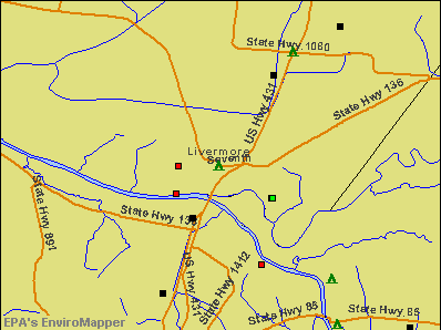
Notable locations in Livermore: East District Fire Department (A), Livermore Fire Department (B). Display/hide their locations on the map
Drinking water stations with addresses in Livermore and their reported violations in the past:
NORTH MCLEAN CO WATER DISTRICT (Population served: 3,715, Purch surface water):Past health violations:LIVERMORE WATER WORKS (Population served: 2,138, Surface water):Past monitoring violations:
- MCL, Monthly (TCR) - In NOV-2013, Contaminant: Coliform. Follow-up actions: St Public Notif requested (JAN-10-2014), St Formal NOV issued (JAN-10-2014), St Compliance achieved (FEB-24-2014), St Public Notif received (MAR-17-2014)
- MCL, Monthly (TCR) - In AUG-2013, Contaminant: Coliform. Follow-up actions: St Public Notif requested (OCT-03-2013), St Formal NOV issued (OCT-03-2013), St Public Notif received (NOV-12-2013), St Compliance achieved (DEC-17-2013)
- 2 minor monitoring violations
Past health violations:Past monitoring violations:
- MCL, Average - Between OCT-2011 and DEC-2011, Contaminant: TTHM. Follow-up actions: St Public Notif requested (JAN-30-2012), St Formal NOV issued (JAN-30-2012), St Public Notif received (MAR-12-2012), St Compliance achieved (MAY-14-2012)
- MCL, Average - Between JUL-2011 and SEP-2011, Contaminant: TTHM. Follow-up actions: St Public Notif requested (NOV-03-2011), St Formal NOV issued (NOV-03-2011), St Public Notif received (DEC-02-2011), St Compliance achieved (MAY-14-2012)
- MCL, Average - Between APR-2011 and JUN-2011, Contaminant: Total Haloacetic Acids (HAA5). Follow-up actions: St Public Notif requested (AUG-09-2011), St Formal NOV issued (AUG-09-2011), St Public Notif received (SEP-01-2011), St Compliance achieved (MAY-14-2012)
- MCL, Average - Between APR-2011 and JUN-2011, Contaminant: TTHM. Follow-up actions: St Public Notif requested (AUG-09-2011), St Formal NOV issued (AUG-09-2011), St Public Notif received (SEP-01-2011), St Compliance achieved (MAY-14-2012)
- MCL, Average - Between JAN-2011 and MAR-2011, Contaminant: Total Haloacetic Acids (HAA5). Follow-up actions: St Public Notif requested (MAY-05-2011), St Formal NOV issued (MAY-05-2011), St Public Notif received (JUN-24-2011), St Compliance achieved (MAY-14-2012)
- MCL, Average - Between JAN-2011 and MAR-2011, Contaminant: TTHM. Follow-up actions: St Public Notif requested (MAY-05-2011), St Formal NOV issued (MAY-05-2011), St Public Notif received (JUN-24-2011), St Compliance achieved (MAY-14-2012)
- 18 other older health violations
- Monitoring and Reporting (DBP) - Between APR-2008 and JUN-2008, Contaminant: TTHM. Follow-up actions: St Public Notif requested (JUL-29-2008), St Formal NOV issued (JUL-29-2008), St Public Notif received (AUG-22-2008), St Compliance achieved (SEP-04-2008)
- Monitoring and Reporting (DBP) - Between APR-2008 and JUN-2008, Contaminant: Total Haloacetic Acids (HAA5). Follow-up actions: St Public Notif requested (JUL-29-2008), St Formal NOV issued (JUL-29-2008), St Public Notif received (AUG-22-2008), St Compliance achieved (SEP-04-2008)
- Monitoring and Reporting (DBP) - Between JAN-2008 and MAR-2008, Contaminant: Total Haloacetic Acids (HAA5). Follow-up actions: St Public Notif requested (APR-23-2008), St Formal NOV issued (APR-23-2008), St Public Notif received (AUG-22-2008), St Compliance achieved (SEP-04-2008)
- Monitoring and Reporting (DBP) - Between JAN-2008 and MAR-2008, Contaminant: TTHM. Follow-up actions: St Public Notif requested (APR-23-2008), St Formal NOV issued (APR-23-2008), St Public Notif received (AUG-22-2008), St Compliance achieved (SEP-04-2008)
- Monitoring and Reporting (DBP) - Between OCT-2007 and DEC-2007, Contaminant: CARBON, TOTAL. Follow-up actions: St Public Notif requested (JAN-03-2008), St Formal NOV issued (JAN-03-2008), St Public Notif received (JAN-03-2008), St Compliance achieved (AUG-06-2008)
- 2 minor monitoring violations
- 3 other older monitoring violations
| This city: | 2.3 people |
| Kentucky: | 2.5 people |
| This city: | 63.3% |
| Whole state: | 66.9% |
| This city: | 7.1% |
| Whole state: | 6.4% |
Likely homosexual households (counted as self-reported same-sex unmarried-partner households)
- Lesbian couples: 0.3% of all households
- Gay men: 0.0% of all households
Banks with branches in Livermore (2011 data):
- First Security Bank of Kentucky: Livermore Office Branch at 201 East Third Street, branch established on 2007/12/03. Info updated 2011/09/09: Bank assets: $68.7 mil, Deposits: $58.9 mil, headquarters in Central City, KY, positive income, 5 total offices, Holding Company: Community Bancorp Of Kentucky, Inc.
- Independence Bank of Kentucky: Henton Street Branch at 614 Henton Street, branch established on 1996/11/22. Info updated 2006/11/03: Bank assets: $1,133.6 mil, Deposits: $949.3 mil, headquarters in Owensboro, KY, positive income, Commercial Lending Specialization, 20 total offices, Holding Company: Independence Bancshares, Inc.
For population 15 years and over in Livermore:

- Never married: 16.5%
- Now married: 53.7%
- Separated: 3.0%
- Widowed: 15.2%
- Divorced: 11.6%
For population 25 years and over in Livermore:
- High school or higher: 82.3%
- Bachelor's degree or higher: 14.1%
- Graduate or professional degree: 6.0%
- Unemployed: 10.6%
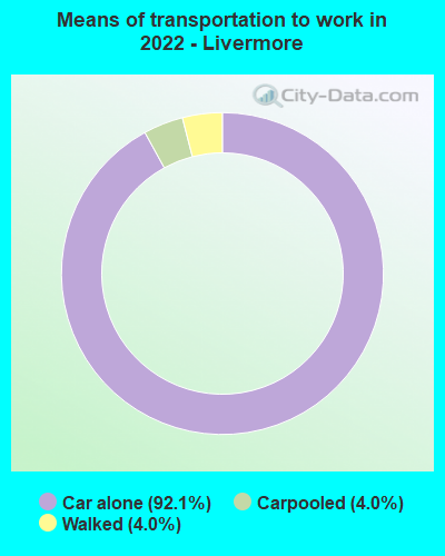
- Mean travel time to work (commute): 30.5 minutes


| Here: | 11.6 |
| Kentucky average: | 11.7 |
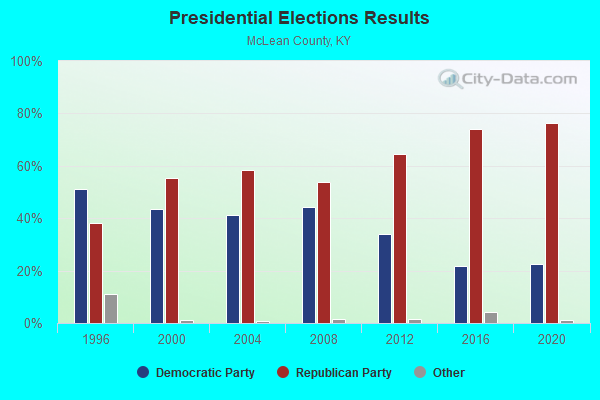
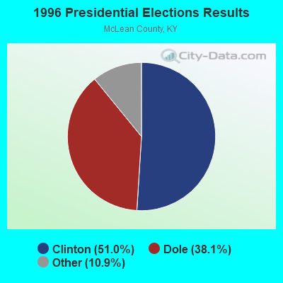
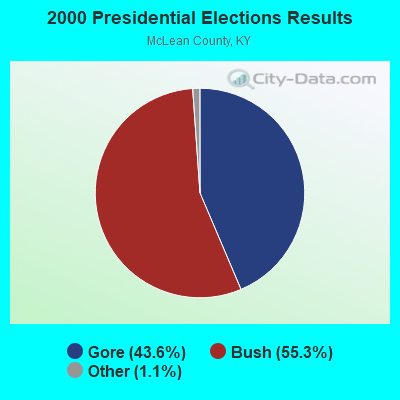
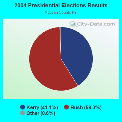
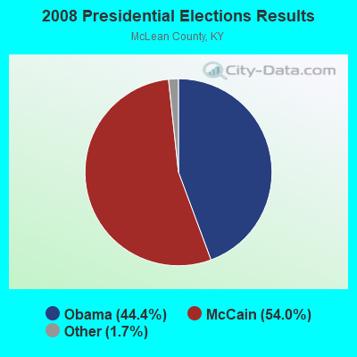
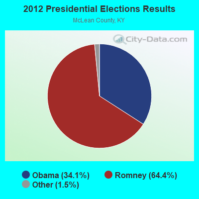
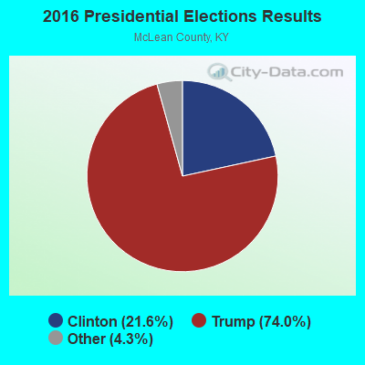
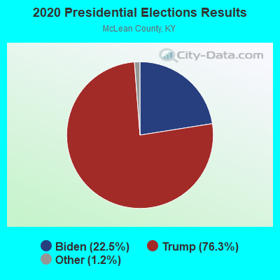
Graphs represent county-level data. Detailed 2008 Election Results
Religion statistics for Livermore, KY (based on McLean County data)
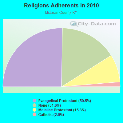
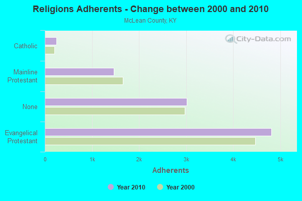
| Religion | Adherents | Congregations |
|---|---|---|
| Evangelical Protestant | 4,813 | 20 |
| Mainline Protestant | 1,463 | 11 |
| Catholic | 245 | 2 |
| Other | - | 1 |
| None | 3,010 | - |
Food Environment Statistics:
| McLean County: | 4.11 / 10,000 pop. |
| Kentucky: | 2.19 / 10,000 pop. |
| McLean County: | 5.14 / 10,000 pop. |
| Kentucky: | 4.36 / 10,000 pop. |
| This county: | 8.23 / 10,000 pop. |
| State: | 5.74 / 10,000 pop. |
| Here: | 13.1% |
| Kentucky: | 11.0% |
| McLean County: | 33.7% |
| Kentucky: | 30.0% |
| McLean County: | 17.9% |
| Kentucky: | 15.9% |
Health and Nutrition:
| This city: | 42.3% |
| Kentucky: | 49.9% |
| Livermore: | 41.2% |
| State: | 47.0% |
| Livermore: | 26.8 |
| Kentucky: | 28.6 |
| This city: | 25.1% |
| Kentucky: | 21.0% |
| Livermore: | 7.1% |
| Kentucky: | 10.1% |
| This city: | 6.8 |
| State: | 6.8 |
| Livermore: | 22.8% |
| Kentucky: | 33.8% |
| Livermore: | 53.3% |
| Kentucky: | 56.8% |
| Here: | 83.5% |
| State: | 78.9% |
More about Health and Nutrition of Livermore, KY Residents
| Local government employment and payroll (March 2022) | |||||
| Function | Full-time employees | Monthly full-time payroll | Average yearly full-time wage | Part-time employees | Monthly part-time payroll |
|---|---|---|---|---|---|
| Streets and Highways | 2 | $3,320 | $19,920 | 0 | $0 |
| Solid Waste Management | 2 | $5,694 | $34,164 | 0 | $0 |
| Financial Administration | 2 | $6,303 | $37,818 | 1 | $1,463 |
| Water Supply | 1 | $4,141 | $49,692 | 0 | $0 |
| Other Government Administration | 0 | $0 | 11 | $1,029 | |
| Firefighters | 0 | $0 | 1 | $569 | |
| Totals for Government | 7 | $19,458 | $33,357 | 13 | $3,061 |
Livermore government finances - Expenditure in 2017 (per resident):
- Current Operations - Housing and Community Development: $358,000 ($295.87)
Water Utilities: $293,000 ($242.15)
Sewerage: $245,000 ($202.48)
Central Staff Services: $112,000 ($92.56)
Parks and Recreation: $68,000 ($56.20)
Regular Highways: $56,000 ($46.28)
Local Fire Protection: $22,000 ($18.18)
Police Protection: $6,000 ($4.96)
- General - Interest on Debt: $36,000 ($29.75)
- Intergovernmental to Local - Other - General - Other: $34,000 ($28.10)
- Other Capital Outlay - Central Staff Services: $25,000 ($20.66)
Water Utilities: $14,000 ($11.57)
Local Fire Protection: $12,000 ($9.92)
Sewerage: $11,000 ($9.09)
Parks and Recreation: $4,000 ($3.31)
Housing and Community Development: $1,000 ($0.83)
- Total Salaries and Wages: $231,000 ($190.91)
- Water Utilities - Interest on Debt: $20,000 ($16.53)
Livermore government finances - Revenue in 2017 (per resident):
- Charges - Sewerage: $340,000 ($280.99)
Parks and Recreation: $82,000 ($67.77)
Other: $31,000 ($25.62)
- Federal Intergovernmental - Housing and Community Development: $330,000 ($272.73)
- Miscellaneous - Rents: $49,000 ($40.50)
Interest Earnings: $11,000 ($9.09)
- Revenue - Water Utilities: $289,000 ($238.84)
- State Intergovernmental - Other: $40,000 ($33.06)
Highways: $23,000 ($19.01)
- Tax - Insurance Premiums Sales: $141,000 ($116.53)
Property: $77,000 ($63.64)
Public Utilities Sales: $37,000 ($30.58)
Occupation and Business License - Other: $6,000 ($4.96)
Other License: $2,000 ($1.65)
Livermore government finances - Debt in 2017 (per resident):
- Long Term Debt - Beginning Outstanding - Unspecified Public Purpose: $1,385,000 ($1144.63)
Outstanding Unspecified Public Purpose: $1,286,000 ($1062.81)
Retired Unspecified Public Purpose: $99,000 ($81.82)
Livermore government finances - Cash and Securities in 2017 (per resident):
- Other Funds - Cash and Securities: $1,042,000 ($861.16)
- Sinking Funds - Cash and Securities: $55,000 ($45.45)
Businesses in Livermore, KY
- Ace Hardware: 1
- Ford: 1
- Subway: 1
Strongest AM radio stations in Livermore:
- WVJS (1420 AM; 5 kW; OWENSBORO, KY; Owner: TSB III, LLC)
- WSM (650 AM; 50 kW; NASHVILLE, TN; Owner: GAYLORD ENTERTAINMENT COMPANY)
- WKDA (1200 AM; 50 kW; NASHVILLE, TN; Owner: RADIO NASHVILLE, INC.)
- WHAS (840 AM; 50 kW; LOUISVILLE, KY; Owner: CLEAR CHANNEL BROADCASTING LICENSES, INC.)
- WNQM (1300 AM; 50 kW; NASHVILLE, TN; Owner: WNQM. INC.)
- WAMB (1160 AM; 50 kW; DONELSON, TN; Owner: GREAT SOUTHERN BROADCASTING COMPANY, INC.)
- WLAC (1510 AM; 50 kW; NASHVILLE, TN; Owner: CAPSTAR TX LIMITED PARTNERSHIP)
- WNES (1050 AM; 1 kW; CENTRAL CITY, KY; Owner: STARLIGHT BROADCASTING CO., INC.)
- WAIA (1600 AM; 1 kW; BEAVER DAM, KY; Owner: STARLIGHT BROADCASTING CO., INC.)
- WGBF (1280 AM; 5 kW; EVANSVILLE, IN; Owner: CLEAR CHANNEL BROADCASTING LICENSES, INC.)
- WKCT (930 AM; 5 kW; BOWLING GREEN, KY; Owner: DAILY NEWS BROADCASTING CO.)
- WOMI (1490 AM; 1 kW; OWENSBORO, KY; Owner: REGENT BROADCASTING OF EVANSVILLE/OWENSBORO, INC.)
- WTTL (1310 AM; 2 kW; MADISONVILLE, KY; Owner: MADISONVILLE CBC, INC.)
Strongest FM radio stations in Livermore:
- WBKR (92.5 FM; OWENSBORO, KY; Owner: REGENT BROADCASTING OF EVANSVILLE/OWENSBORO, INC.)
- WSTO (96.1 FM; OWENSBORO, KY; Owner: TSB III, LLC)
- WQXQ (101.9 FM; CENTRAL CITY, KY; Owner: STARLIGHT BROADCASTING CO., INC.)
- WXCM (97.1 FM; HAWESVILLE, KY; Owner: WLME, INC.)
- WYMV (106.9 FM; MADISONVILLE, KY; Owner: MADISONVILLE CBC, INC.)
- WKTG (93.9 FM; MADISONVILLE, KY; Owner: SOUND BROADCASTERS, INC.)
- WXMZ (106.3 FM; HARTFORD, KY; Owner: STARLIGHT BROADCASTING CO., INC.)
- W278AD (103.5 FM; CENTRAL CITY, KY; Owner: HEARTLAND MINISTRIES, INC.)
- WVVR (100.3 FM; HOPKINSVILLE, KY; Owner: SAGA COMMUNICATIONS OF TUCKESSEE, LLC)
- WKDQ (99.5 FM; HENDERSON, KY; Owner: REGENT BROADCASTING OF EVANSVILLE/OWENSBORO, INC.)
- WBIO (94.7 FM; PHILPOT, KY; Owner: THE CROMWELL GROUP, INC OF KENTUCKY)
- WUBT (101.1 FM; RUSSELLVILLE, KY; Owner: CAPSTAR TX LIMITED PARTNERSHIP)
- WNIN-FM (88.3 FM; EVANSVILLE, IN; Owner: TRI-STATE PUBLIC TELEPLEX, INC.)
- WTCJ-FM (105.7 FM; TELL CITY, IN; Owner: HANCOCK COMMUNICATIONS, INC.)
- WYXY (107.1 FM; BOONVILLE, IN; Owner: BOONVILLE BROADCASTING CO., INC.)
- WKYA (105.5 FM; GREENVILLE, KY; Owner: STARLIGHT BROADCASTING CO., INC.)
- WNTC (103.9 FM; DRAKESBORO, KY; Owner: NASHVILLE'S SPORTSRADIO, INCORPORATED)
- W246AF (97.1 FM; OWENSBORO, KY; Owner: FM 90.1, INC.)
- WSOF-FM (89.9 FM; MADISONVILLE, KY; Owner: MADISONVILLE CHRISTIAN SCHOOL)
- W235AC (94.9 FM; MADISONVILLE, KY; Owner: HEARTLAND MINISTRIES, INC.)
TV broadcast stations around Livermore:
- WKMA-TV (Channel 35; MADISONVILLE, KY; Owner: KENTUCKY AUTHORITY FOR EDUCATIONAL TV)
- WNIN (Channel 9; EVANSVILLE, IN; Owner: TRI-STATE PUBLIC TELEPLEX, INC.)
- WAZE-TV (Channel 19; MADISONVILLE, KY; Owner: SOUTH CENTRAL COMMUNICATIONS CORP.)
- WEHT (Channel 25; EVANSVILLE, IN; Owner: GILMORE BROADCASTING CORPORATION)
- WTVW (Channel 7; EVANSVILLE, IN; Owner: QUORUM OF INDIANA LICENSE, LLC)
- WFIE (Channel 14; EVANSVILLE, IN; Owner: LIBCO, INC.)
- WEVV (Channel 44; EVANSVILLE, IN; Owner: COMCORP OF INDIANA LICENSE CORP.)
- W62CJ (Channel 62; JACKSON, TN; Owner: MS COMMUNICATIONS, LLC)
- WKOH (Channel 31; OWENSBORO, KY; Owner: KENTUCKY AUTHORITY FOR EDUCATIONAL TV)
- W12BJ (Channel 12; OWENSBORO, KY; Owner: UNIVERSITY OF KENTUCKY)
Livermore fatal accident list:
Aug 1, 2000 11:58 AM, Us-431, Vehicles: 1, Persons: 1, Fatalities: 1
Aug 29, 1994 05:27 AM, 431, Vehicles: 2, Persons: 2, Fatalities: 1
Dec 22, 1992 06:05 PM, 136, Vehicles: 2, Persons: 5, Fatalities: 1
Sep 27, 1977 11:45 AM, Vehicles: 3, Persons: 5, Fatalities: 1
- National Bridge Inventory (NBI) Statistics
- 21Number of bridges
- 302ft / 91.6mTotal length
- $9,105,000Total costs
- 47,016Total average daily traffic
- 5,718Total average daily truck traffic

- New bridges - historical statistics
- 21920-1929
- 51930-1939
- 21940-1949
- 41950-1959
- 21960-1969
- 21970-1979
- 31980-1989
- 11990-1999
FCC Registered Cell Phone Towers:
1 (See the full list of FCC Registered Cell Phone Towers in Livermore)FCC Registered Antenna Towers:
26 (See the full list of FCC Registered Antenna Towers)FCC Registered Broadcast Land Mobile Towers:
10 (See the full list of FCC Registered Broadcast Land Mobile Towers in Livermore, KY)FCC Registered Microwave Towers:
4- LIVERMORE, On Schneider Tanney Rd Off Hwy 136 2 Mi W (Lat: 37.520028 Lon: -87.153583), Overall height: 94.5 m, Call Sign: WPNI223,
Assigned Frequencies: 6616.25 MHz, Grant Date: 02/13/2001, Expiration Date: 02/01/2011, Cancellation Date: 06/12/2003, Certifier: Kellye E Abernathy, Registrant: Bellsouth Personal Communications, LLC, 17330 Preston Rd. Suite 100a, Dallas, TX 75252, Phone: (972) 733-2000, Fax: (972) 733-8141
- Livermore, Various Locations (Lat: 37.437500 Lon: -87.187778), Overall height: 6.1 m, Call Sign: WPNI431,
Assigned Frequencies: 956.343 MHz, Grant Date: 01/06/2023, Expiration Date: 03/20/2033, Registrant: Keller And Heckman LLP, 1001 G Street Nw, Suite 500 West, Washington, DC 20001, Phone: (202) 434-4100, Fax: (202) 434-4646, Email:
- LIVERMORE, 550 Schneider Tanner Road (Lat: 37.519972 Lon: -87.153806), Type: Mtower, Structure height: 90.2 m, Overall height: 95.4 m, Call Sign: WRZA660,
Assigned Frequencies: 11245.0 MHz, 11245.0 MHz, 11245.0 MHz, 11245.0 MHz, 11245.0 MHz, 11245.0 MHz, 11245.0 MHz, 11245.0 MHz, 11245.0 MHz, 11245.0 MHz, 11245.0 MHz, 11245.0 MHz, Grant Date: 10/11/2023, Expiration Date: 10/11/2033, Certifier: Kyle Gardner, Registrant: W.A.T.C.H. Tv Company Inc, 807 S. Sr 3, Rushville, IN 46173, Phone: (866) 586-1518, Email:
- WILSON, 4.0 Miles Se Of Livermore, Ky (Lat: 37.450833 Lon: -87.087778), Type: Ltower, Structure height: 76 m, Call Sign: KBL53,
Assigned Frequencies: 6226.89 MHz, 6345.49 MHz, 6404.79 MHz, 6286.19 MHz, 6655.00 MHz, 6685.00 MHz, 6655.00 MHz, 6685.00 MHz, 6655.00 MHz, 6685.00 MHz... (+38 more), Grant Date: 07/09/2021, Expiration Date: 08/08/2031, Registrant: Micronet Communications, Inc., 812 Lexington Dr, Plano, TX 75075, Phone: (972) 422-7200, Email:
FCC Registered Amateur Radio Licenses:
12 (See the full list of FCC Registered Amateur Radio Licenses in Livermore)2002 - 2018 National Fire Incident Reporting System (NFIRS) incidents
- Fire incident types reported to NFIRS in Livermore, KY
- 7343.5%Structure Fires
- 6236.9%Outside Fires
- 1710.1%Mobile Property/Vehicle Fires
- 169.5%Other
 According to the data from the years 2002 - 2018 the average number of fires per year is 10. The highest number of reported fires - 36 took place in 2013, and the least - 0 in 2016. The data has a dropping trend.
 When looking into fire subcategories, the most reports belonged to: Structure Fires (43.5%), and Outside Fires (36.9%).
| Most common first names in Livermore, KY among deceased individuals | ||
| Name | Count | Lived (average) |
|---|---|---|
| James | 31 | 70.8 years |
| William | 25 | 75.2 years |
| Charles | 15 | 65.5 years |
| John | 14 | 81.5 years |
| Robert | 14 | 67.6 years |
| Mary | 13 | 79.4 years |
| Anna | 8 | 80.1 years |
| Roy | 8 | 75.6 years |
| Oscar | 7 | 76.4 years |
| Martha | 7 | 79.0 years |
| Most common last names in Livermore, KY among deceased individuals | ||
| Last name | Count | Lived (average) |
|---|---|---|
| Johnson | 18 | 73.9 years |
| Howard | 17 | 73.0 years |
| Brown | 15 | 75.5 years |
| Boyken | 13 | 64.1 years |
| Coffman | 11 | 74.4 years |
| Atherton | 10 | 80.9 years |
| Willis | 9 | 65.3 years |
| Cox | 9 | 76.5 years |
| Miller | 9 | 64.0 years |
| Burden | 8 | 75.9 years |

Livermore compared to Kentucky state average:
- Median household income significantly below state average.
- Median house value below state average.
- Black race population percentage significantly below state average.
- Hispanic race population percentage significantly below state average.
- Foreign-born population percentage significantly below state average.
- Length of stay since moving in significantly above state average.
- Number of college students significantly below state average.