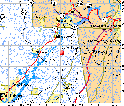
Long Island, Alabama
Submit your own pictures of this place and show them to the world
- OSM Map
- General Map
- Google Map
- MSN Map
| Males: 2,990 | |
| Females: 3,091 |
| Median resident age: | 35.8 years |
| Alabama median age: | 35.8 years |
Zip code: 35966
| Long Island: | $45,349 |
| AL: | $59,674 |
Estimated per capita income in 2022: $23,575 (it was $13,445 in 2000)
Long Island CCD income, earnings, and wages data
Estimated median house or condo value in 2022: $132,088 (it was $58,000 in 2000)
| Long Island: | $132,088 |
| AL: | $200,900 |
Mean prices in 2022: all housing units: $182,987; detached houses: $212,880; townhouses or other attached units: $138,460; mobile homes: $66,728; occupied boats, rvs, vans, etc.: $51,590
Detailed information about poverty and poor residents in Long Island, AL
Compare current foreclosures near Long Island, AL:
| Photo | Address | Area | Beds / Baths | Price | Details |
|---|---|---|---|---|---|

|
#1
County Road 681
Flat Rock, AL 35966
|
1,697 sq. feet
|
2 baths 3 beds |
$234,900
|
show details |

|
#2
Hass Rd
Jasper, TN 37347
|
1,680 sq. feet
|
2 baths 3 beds |
show details | |

|
#3
Sweetens Cove Rd
South Pittsburg, TN 37380
|
1,650 sq. feet
|
2 baths 2 beds |
show details | |

|
#4
Co Rd 138
Henagar, AL 35978
|
2,496 sq. feet
|
1 baths 3 beds |
show details | |

|
#5
County Road 138
Henagar, AL 35978
|
1,949 sq. feet
|
1 baths - beds |
show details | |

|
#6
Creek Rd
Wildwood, GA 30757
|
1,560 sq. feet
|
2 baths 3 beds |
show details | |

|
#7
Highway 157
Lookout Mountain, GA 30750
|
1,466 sq. feet
|
2 baths - beds |
show details | |

|
#8
N Case Ave
Trenton, GA 30752
|
1,320 sq. feet
|
2 baths - beds |
show details | |

|
#9
Marion Ave
South Pittsburg, TN 37380
|
1,768 sq. feet
|
1 baths - beds |
show details | |

|
#10
Pleasant Grove Rd
Jasper, TN 37347
|
1,025 sq. feet
|
1 baths - beds |
show details |
| Photo | Address | Area | Beds / Baths | Price | Details |
|---|---|---|---|---|---|

|
#11
Poplar Ave
Trenton, GA 30752
|
1,416 sq. feet
|
1 baths - beds |
show details | |

|
#12
Bernice Dr
Trenton, GA 30752
|
1,270 sq. feet
|
2 baths - beds |
show details | |

|
#13
N Moore Rd
Rising Fawn, GA 30738
|
1,568 sq. feet
|
1 baths - beds |
show details | |

|
#14
Laurel Ave
South Pittsburg, TN 37380
|
1,645 sq. feet
|
1 baths - beds |
show details | |

|
#15
Bernice Dr
Trenton, GA 30752
|
1,352 sq. feet
|
2 baths - beds |
show details | |

|
#16
2nd St
South Pittsburg, TN 37380
|
1,381 sq. feet
|
1 baths - beds |
show details | |

|
#17
Scratch Ankle Rd
Trenton, GA 30752
|
- sq. feet
|
1 baths 2 beds |
show details | |

|
#18
N Main St
Trenton, GA 30752
|
1,594 sq. feet
|
1 baths - beds |
show details | |

|
#19
Dennis Ave
Jasper, TN 37347
|
2,294 sq. feet
|
2 baths - beds |
show details | |

|
#20
Tony Rd
Trenton, GA 30752
|
- sq. feet
|
1 baths 3 beds |
show details |
| Photo | Address | Area | Beds / Baths | Price | Details |
|---|---|---|---|---|---|

|
#21
Patton School Rd
South Pittsburg, TN 37380
|
1,056 sq. feet
|
2 baths - beds |
show details | |

|
#22
Connecticut Ave
Trenton, GA 30752
|
1,175 sq. feet
|
1 baths - beds |
show details | |

|
#23
S Pittsburg Mountain Rd
South Pittsburg, TN 37380
|
1,008 sq. feet
|
1 baths - beds |
show details | |

|
#24
County Road 443
Fackler, AL 35746
|
1,560 sq. feet
|
1 baths - beds |
show details | |

|
#25
View St
Jasper, TN 37347
|
3,281 sq. feet
|
1 baths - beds |
show details | |

|
#26
Main St
Jasper, TN 37347
|
1,073 sq. feet
|
1 baths - beds |
show details | |

|
#27
Highway 11
Rising Fawn, GA 30738
|
960 sq. feet
|
1 baths - beds |
show details | |

|
#28
1st Ave
Jasper, TN 37347
|
1,566 sq. feet
|
1 baths - beds |
show details | |

|
#29
Nickajack Cir
Jasper, TN 37347
|
1,224 sq. feet
|
2 baths - beds |
show details | |

|
#30
Riverbend Dr
Jasper, TN 37347
|
2,856 sq. feet
|
2 baths - beds |
show details |
| Photo | Address | Area | Beds / Baths | Price | Details |
|---|---|---|---|---|---|

|
#31
Putnam Ave
South Pittsburg, TN 37380
|
2,498 sq. feet
|
1 baths - beds |
show details | |

|
#32
Highland Ave
Jasper, TN 37347
|
864 sq. feet
|
1 baths - beds |
show details | |

|
#33
Road 973
Flat Rock, AL 35966
|
2,076 sq. feet
|
1 baths - beds |
show details | |

|
#34
Alabama Ave
Bridgeport, AL 35740
|
1,392 sq. feet
|
2 baths - beds |
show details | |

|
#35
Gold Rd
Jasper, TN 37347
|
1,100 sq. feet
|
1 baths - beds |
show details | |

|
#36
Highway 301
Trenton, GA 30752
|
1,178 sq. feet
|
1 baths - beds |
show details | |

|
#37
Gail Ln
Jasper, TN 37347
|
900 sq. feet
|
2 baths - beds |
show details | |

|
#38
Bolton Rd
Trenton, GA 30752
|
3,760 sq. feet
|
1 baths - beds |
show details | |

|
#39
Francis Spring Rd
Jasper, TN 37347
|
1,456 sq. feet
|
2 baths - beds |
show details | |

|
#40
Mayfair Ave
Jasper, TN 37347
|
1,489 sq. feet
|
2 baths - beds |
show details |
| Photo | Address | Area | Beds / Baths | Price | Details |
|---|---|---|---|---|---|

|
#41
Scenic Hwy
Lookout Mountain, GA 30750
|
1,335 sq. feet
|
1 baths - beds |
show details | |

|
#42
Prater Rd
Trenton, GA 30752
|
1,248 sq. feet
|
1 baths - beds |
show details | |

|
#43
Sweetens Cove Rd
South Pittsburg, TN 37380
|
1,960 sq. feet
|
1 baths - beds |
show details | |

|
#44
Glendale Ct
Trenton, GA 30752
|
2,011 sq. feet
|
2 baths - beds |
show details | |

|
#45
Pryor Cove Rd
Jasper, TN 37347
|
1,392 sq. feet
|
2 baths - beds |
show details | |

|
#46
Highway 134
Guild, TN 37340
|
1,960 sq. feet
|
- baths - beds |
show details | |

|
#47
Pryor Cove Rd
Jasper, TN 37347
|
- sq. feet
|
- baths - beds |
show details | |

|
#48
County Road 376
Pisgah, AL 35765
|
- sq. feet
|
- baths - beds |
show details | |

|
#49
Bolton Point Rd
South Pittsburg, TN 37380
|
- sq. feet
|
- baths - beds |
show details | |

|
Check over 1 million property listings on Foreclosure.com!
|
browse all offers | |||

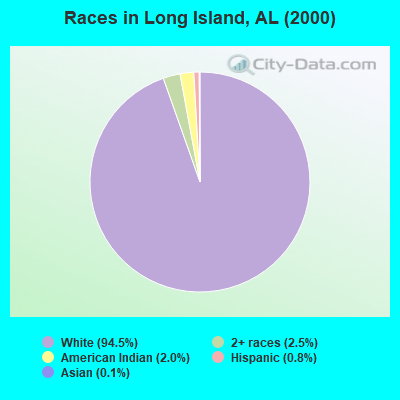
- 5,88494.5%White alone
- 1552.5%Two or more races
- 1242.0%American Indian alone
- 520.8%Hispanic
- 70.1%Asian alone
- 20.03%Black alone
 Recent articles from our blog. Our writers, many of them Ph.D. graduates or candidates, create easy-to-read articles on a wide variety of topics.
Current Local Time: CST time zone
Elevation: 650 feet
Land area: 134.6 square miles.
Population density: 45 people per square mile (very low).

| Long Island CCD: | 0.3% ($199) |
| Alabama: | 0.4% ($289) |
Nearest city with pop. 50,000+: Chattanooga, TN  (27.1 miles , pop. 155,554).
Nearest city with pop. 200,000+: Atlanta, GA (106.1 miles , pop. 416,474).
Nearest city with pop. 1,000,000+: Chicago, IL (494.3 miles , pop. 2,896,016).
Nearest cities:
), ), )Latitude: 34.87 N, Longitude: 85.69 W

| Here: | 2.8% |
| Alabama: | 2.6% |
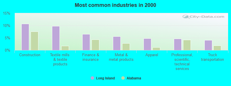
- Construction (10.7%)
- Textile mills & textile products (9.8%)
- Finance & insurance (6.5%)
- Metal & metal products (5.6%)
- Apparel (4.7%)
- Professional, scientific, technical services (4.6%)
- Truck transportation (4.1%)
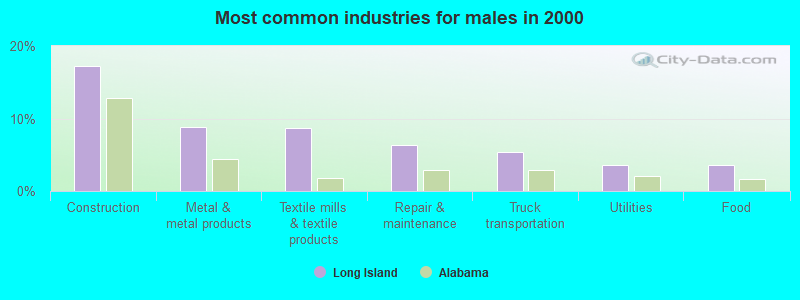
- Construction (17.2%)
- Metal & metal products (8.9%)
- Textile mills & textile products (8.7%)
- Repair & maintenance (6.4%)
- Truck transportation (5.3%)
- Utilities (3.6%)
- Food (3.5%)

- Finance & insurance (15.7%)
- Textile mills & textile products (11.4%)
- Educational services (7.8%)
- Apparel (7.2%)
- Professional, scientific, technical services (6.3%)
- Health care (6.0%)
- Social assistance (4.3%)
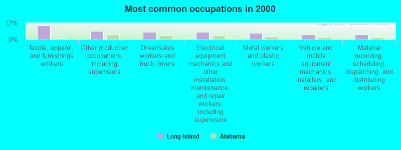
- Textile, apparel, and furnishings workers (10.3%)
- Other production occupations, including supervisors (6.1%)
- Driver/sales workers and truck drivers (5.5%)
- Electrical equipment mechanics and other installation, maintenance, and repair workers, including supervisors (5.5%)
- Metal workers and plastic workers (4.7%)
- Vehicle and mobile equipment mechanics, installers, and repairers (3.5%)
- Material recording, scheduling, dispatching, and distributing workers (3.5%)
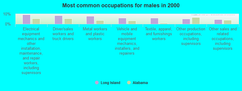
- Electrical equipment mechanics and other installation, maintenance, and repair workers, including supervisors (9.4%)
- Driver/sales workers and truck drivers (8.5%)
- Metal workers and plastic workers (7.8%)
- Vehicle and mobile equipment mechanics, installers, and repairers (6.1%)
- Textile, apparel, and furnishings workers (6.0%)
- Other production occupations, including supervisors (5.2%)
- Other sales and related occupations, including supervisors (4.4%)
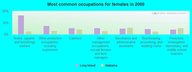
- Textile, apparel, and furnishings workers (16.4%)
- Other production occupations, including supervisors (7.4%)
- Cashiers (5.6%)
- Other management occupations, except farmers and farm managers (5.6%)
- Secretaries and administrative assistants (5.2%)
- Bookkeeping, accounting, and auditing clerks (4.6%)
- Preschool, kindergarten, elementary, and middle school teachers (4.4%)
Average climate in Long Island, Alabama
Based on data reported by over 4,000 weather stations


(lower is better)
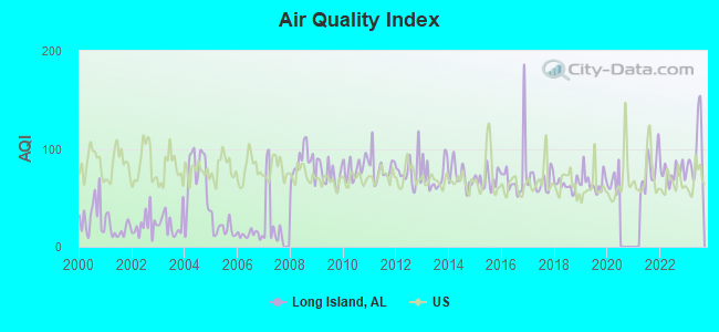
Air Quality Index (AQI) level in 2023 was 96.8. This is worse than average.
| City: | 96.8 |
| U.S.: | 72.6 |
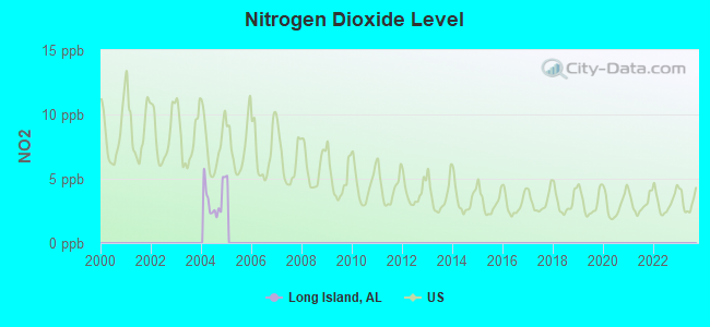
Nitrogen Dioxide (NO2) [ppb] level in 2004 was 3.44. This is significantly better than average. Closest monitor was 1.9 miles away from the city center.
| City: | 3.44 |
| U.S.: | 5.11 |
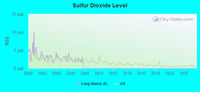
Sulfur Dioxide (SO2) [ppb] level in 2007 was 2.27. This is significantly worse than average. Closest monitor was 1.7 miles away from the city center.
| City: | 2.27 |
| U.S.: | 1.51 |
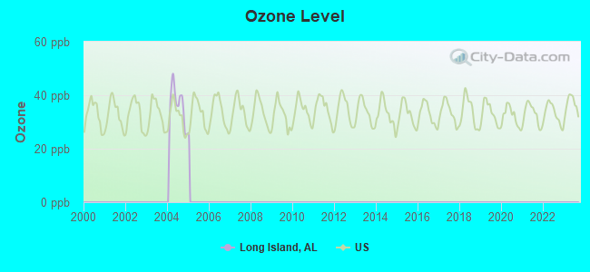
Ozone [ppb] level in 2004 was 36.3. This is about average. Closest monitor was 1.9 miles away from the city center.
| City: | 36.3 |
| U.S.: | 33.3 |
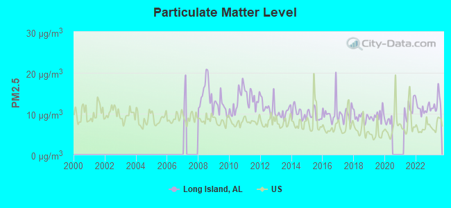
Particulate Matter (PM2.5) [µg/m3] level in 2023 was 12.5. This is significantly worse than average. Closest monitor was 23.5 miles away from the city center.
| City: | 12.5 |
| U.S.: | 8.1 |
Tornado activity:
Long Island-area historical tornado activity is near Alabama state average. It is 89% greater than the overall U.S. average.
On 2/6/2008, a category F4 (max. wind speeds 207-260 mph) tornado 15.9 miles away from the Long Island place center killed one person and injured 12 people.
On 5/19/1973, a category F4 tornado 25.3 miles away from the place center injured 19 people and caused between $500,000 and $5,000,000 in damages.
Earthquake activity:
Long Island-area historical earthquake activity is significantly above Alabama state average. It is 127% greater than the overall U.S. average.On 4/29/2003 at 08:59:39, a magnitude 4.9 (4.4 MB, 4.6 MW, 4.9 LG, Class: Light, Intensity: IV - V) earthquake occurred 25.9 miles away from the city center
On 4/29/2003 at 08:59:39, a magnitude 4.6 (4.6 MW, Depth: 12.3 mi) earthquake occurred 25.9 miles away from Long Island center
On 1/18/1999 at 07:00:53, a magnitude 4.8 (4.8 MB, 4.0 LG, Depth: 0.6 mi) earthquake occurred 135.0 miles away from the city center
On 11/30/1973 at 07:48:41, a magnitude 4.7 (4.7 MB, 4.6 ML) earthquake occurred 117.0 miles away from the city center
On 12/12/2018 at 09:14:43, a magnitude 4.4 (4.4 MW, Depth: 4.9 mi) earthquake occurred 74.9 miles away from Long Island center
On 4/18/2008 at 09:36:59, a magnitude 5.4 (5.1 MB, 4.8 MS, 5.4 MW, 5.2 MW, Class: Moderate, Intensity: VI - VII) earthquake occurred 276.4 miles away from Long Island center
Magnitude types: regional Lg-wave magnitude (LG), body-wave magnitude (MB), local magnitude (ML), surface-wave magnitude (MS), moment magnitude (MW)
Natural disasters:
The number of natural disasters in Jackson County (23) is greater than the US average (15).Major Disasters (Presidential) Declared: 13
Emergencies Declared: 5
Causes of natural disasters: Storms: 12, Floods: 10, Tornadoes: 10, Winds: 5, Hurricanes: 3, Fires: 2, Winter Storms: 2, Drought: 1, Snowfall: 1, Other: 1 (Note: some incidents may be assigned to more than one category).
Colleges/universities with over 2000 students nearest to Long Island:
- Northeast Alabama Community College (about 26 miles; Rainsville, AL; Full-time enrollment: 2,409)
- The University of Tennessee-Chattanooga (about 26 miles; Chattanooga, TN; FT enrollment: 10,158)
- Chattanooga State Community College (about 31 miles; Chattanooga, TN; FT enrollment: 6,827)
- Southern Adventist University (about 39 miles; Collegedale, TN; FT enrollment: 2,898)
- Dalton State College (about 40 miles; Dalton, GA; FT enrollment: 3,846)
- Motlow State Community College (about 49 miles; Tullahoma, TN; FT enrollment: 2,915)
- Berry College (about 50 miles; Mount Berry, GA; FT enrollment: 2,102)
Points of interest:
Notable locations in Long Island: Hill Poultry Farm (A), Reese Ferry Landing (B), Bryant Community Center (C), Flat Rock Fire Department (D), Tri - Community Volunteer Fire Department Higdon Station (E), Tri - Community Volunteer Fire Department Bryant Station 2 (F), Tri - Community Volunteer Fire Department Bryant Station (G). Display/hide their locations on the map
Churches in Long Island include: Mountain View Church (A), Old Fabius Church (B), Mount Olive Church (C), Morning Star Church (D), Liberty Hill Church (E), Kennamer Church (F), Glorious Church (G), Christian Home Church (H), Browns Chapel (I). Display/hide their locations on the map
Cemeteries: Porter Cemetery (1), Potato Hill Cemetery (2), James Cemetery (3), Moore Chapel Cemetery (4), Ebenezer Cemetery (5), Smith Cemetery (6), Wheeler Cemetery (7). Display/hide their locations on the map
Reservoirs: Robert Shrader Lake (A), Mansel Wolf Lake (B). Display/hide their locations on the map
Streams, rivers, and creeks: Sterne Branch (A), Smith Creek (B), Sanka Branch (C), Lively Creek (D), Long Island Creek (E), Monday Branch (F), Pond Creek (G), Nichols Branch (H), Muscrowe Branch (I). Display/hide their locations on the map
Park in Long Island: Raccoon Creek Public Hunting Area (1). Display/hide its location on the map
| This place: | 2.6 people |
| Alabama: | 2.5 people |
| This place: | 74.8% |
| Whole state: | 67.8% |
| This place: | 4.1% |
| Whole state: | 4.7% |
Likely homosexual households (counted as self-reported same-sex unmarried-partner households)
- Lesbian couples: 0.2% of all households
- Gay men: 0.1% of all households
| This place: | 15.3% |
| Whole state: | 16.1% |
| This place: | 6.0% |
| Whole state: | 7.3% |
For population 15 years and over in Long Island:
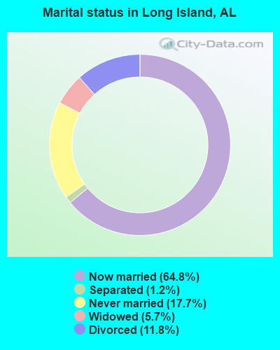
- Never married: 17.7%
- Now married: 64.8%
- Separated: 1.2%
- Widowed: 5.7%
- Divorced: 11.8%
For population 25 years and over in Long Island:
- High school or higher: 60.8%
- Bachelor's degree or higher: 3.8%
- Graduate or professional degree: 0.6%
- Unemployed: 4.8%
- Mean travel time to work (commute): 36.1 minutes
| Here: | 12.5 |
| Alabama average: | 13.2 |
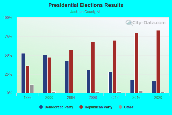
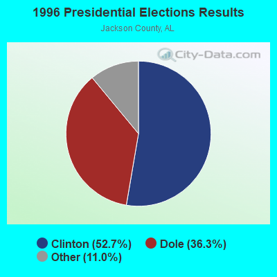
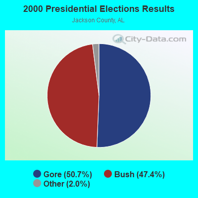
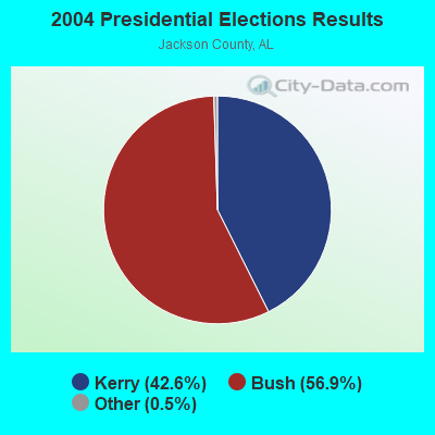
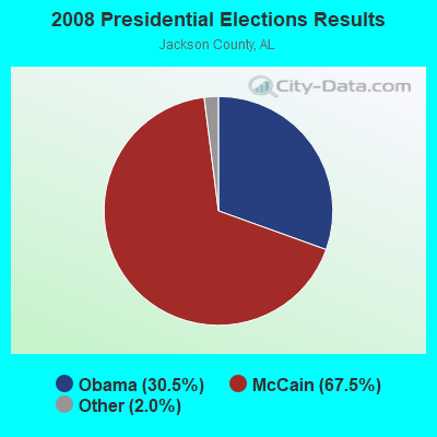

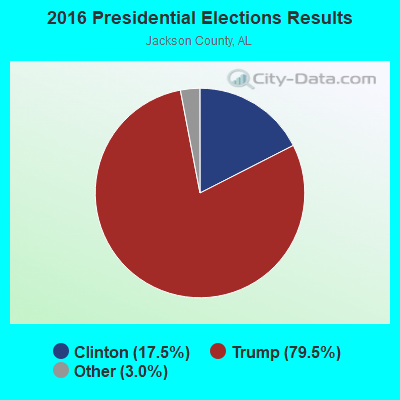
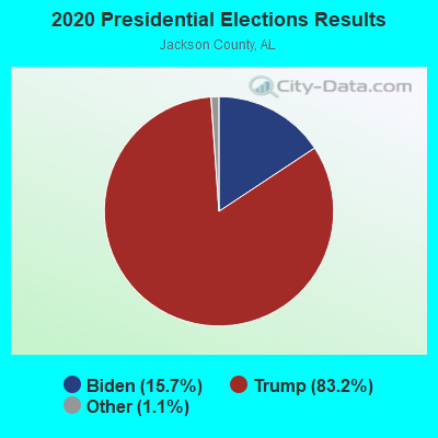
Graphs represent county-level data. Detailed 2008 Election Results
Religion statistics for Long Island, AL (based on Jackson County data)
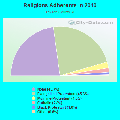
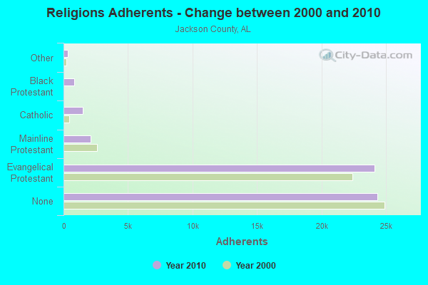
| Religion | Adherents | Congregations |
|---|---|---|
| Evangelical Protestant | 24,116 | 118 |
| Mainline Protestant | 2,116 | 18 |
| Catholic | 1,515 | 1 |
| Black Protestant | 845 | 6 |
| Other | 330 | 2 |
| None | 24,305 | - |
Food Environment Statistics:
| Jackson County: | 3.02 / 10,000 pop. |
| Alabama: | 1.89 / 10,000 pop. |
| Jackson County: | 0.19 / 10,000 pop. |
| Alabama: | 0.20 / 10,000 pop. |
| This county: | 0.76 / 10,000 pop. |
| Alabama: | 0.65 / 10,000 pop. |
| Here: | 5.10 / 10,000 pop. |
| Alabama: | 6.32 / 10,000 pop. |
| Jackson County: | 5.29 / 10,000 pop. |
| Alabama: | 5.75 / 10,000 pop. |
| Jackson County: | 11.6% |
| Alabama: | 11.8% |
| Here: | 30.8% |
| Alabama: | 31.7% |
| This county: | 11.0% |
| State: | 13.5% |
Strongest AM radio stations in Long Island:
- WWAM (820 AM; daytime; 50 kW; JASPER, TN; Owner: SHELTON BROADCASTING SYSTEM)
- WFLI (1070 AM; 50 kW; LOOKOUT MOUNTAIN, TN; Owner: WFLI, INC.)
- WEPG (910 AM; 5 kW; SOUTH PITTSBURG, TN; Owner: STONE/COLLINS COMMUNICATIONS, INC.)
- WQRX (870 AM; daytime; 10 kW; VALLEY HEAD, AL; Owner: BARINOWSKI INVESTMENT COMPANY)
- WYMR (1480 AM; 1 kW; BRIDGEPORT, AL; Owner: DADE COUNTY BROADCASTING, INC.)
- WKWN (1420 AM; 2 kW; TRENTON, GA; Owner: RA-AD OF TRENTON, INC.)
- WNSI (810 AM; 50 kW; JACKSONVILLE, AL; Owner: UNITED BROADCASTING NETWORK, INC.)
- WLOR (1550 AM; 50 kW; HUNTSVILLE, AL; Owner: BCA RADIO, LLC)
- WZCT (1330 AM; 5 kW; SCOTTSBORO, AL; Owner: BONNER AND CARLILE ENTERPRISES)
- WSM (650 AM; 50 kW; NASHVILLE, TN; Owner: GAYLORD ENTERTAINMENT COMPANY)
- WGOW (1150 AM; 5 kW; CHATTANOOGA, TN; Owner: CITADEL BROADCASTING COMPANY)
- WKNG (1060 AM; daytime; 50 kW; TALLAPOOSA, GA; Owner: WKNG, INC.)
- WGST (640 AM; 50 kW; ATLANTA, GA; Owner: CITICASTERS LICENSES, L.P.)
Strongest FM radio stations in Long Island:
- WMXN-FM (101.7 FM; STEVENSON, AL; Owner: KEA RADIO, INC.)
- WMXF-FM (97.3 FM; SOUTH PITTSBURG, TN; Owner: CAPSTAR TX LIMITED PARTNERSHIP)
- WBDX (102.7 FM; TRENTON, GA; Owner: PARTNERS FOR CHRISTIAN RADIO, INC.)
- WMBW (88.9 FM; CHATTANOOGA, TN; Owner: THE MOODY BIBLE INSTITUTE OF CHICAGO)
- W257AZ (99.3 FM; LOOKOUT MOUNTAIN, TN; Owner: CAPSTAR TX LIMITED PARTNERSHIP)
- WUSY (100.7 FM; CLEVELAND, TN; Owner: CAPSTAR TX LIMITED PARTNERSHIP)
- WDEF-FM (92.3 FM; CHATTANOOGA, TN; Owner: JACKSON TELECASTERS, INC.)
- WDOD-FM (96.5 FM; CHATTANOOGA, TN; Owner: WDOD OF CHATTANOOGA, INC.)
- WSKZ (106.5 FM; CHATTANOOGA, TN; Owner: CITADEL BROADCASTING COMPANY)
- WKXJ (98.1 FM; SIGNAL MOUNTAIN, TN; Owner: CAPSTAR TX LIMITED PARTNERSHIP)
- WOGT (107.9 FM; EAST RIDGE, TN; Owner: CITADEL BROADCASTING COMPANY)
- W278AC (103.5 FM; WALDEN, TN; Owner: CAPSTAR TX LIMITED PARTNERSHIP)
- WAWL-FM (91.5 FM; RED BANK, TN; Owner: CHATTANOOGA STATE TECHNICAL COMMUNITY COLLEGE)
- WDYN (89.7 FM; CHATTANOOGA, TN; Owner: TENNESSEE TEMPLE UNIVERSITY)
- WKEA-FM (98.3 FM; SCOTTSBORO, AL; Owner: KEA RADIO, INC.)
- WUTC (88.1 FM; CHATTANOOGA, TN; Owner: UNIVERSITY OF TENNESSEE)
- WSMC-FM (90.5 FM; COLLEGEDALE, TN; Owner: SOUTHERN COLLEGE OF SEVENTH-DAY ADVT)
- WRXR-FM (105.5 FM; ROSSVILLE, GA; Owner: CAPSTAR TX LIMITED PARTNERSHIP)
- WAHR (99.1 FM; HUNTSVILLE, AL; Owner: BCA RADIO, LLC)
- W268AA (101.5 FM; FALLING WATER, TN; Owner: S/WEST FLORIDA COMMUNITY RADIO, INC.)
TV broadcast stations around Long Island:
- WFLI-TV (Channel 53; CLEVELAND, TN; Owner: CHATTANOOGA MEDIA HOLDINGS, L.L.C.)
- W64BJ (Channel 64; SCOTTSBORO, AL; Owner: TRINITY BROADCASTING NETWORK)
- WELF (Channel 23; DALTON, GA; Owner: TRINITY BROADCASTING NETWORK)
- WZDX (Channel 54; HUNTSVILLE, AL; Owner: HUNTSVILLE TELEVISION ACQUISITION CORP.)
- WDEF-TV (Channel 12; CHATTANOOGA, TN; Owner: MEDIA GENERAL COMMUNICATIONS, INC.)
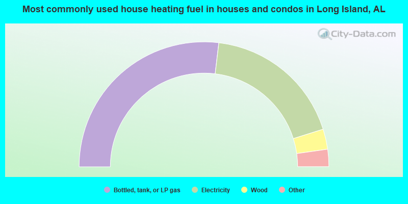
- 53.8%Bottled, tank, or LP gas
- 36.5%Electricity
- 5.2%Wood
- 1.7%Fuel oil, kerosene, etc.
- 1.6%No fuel used
- 1.2%Utility gas
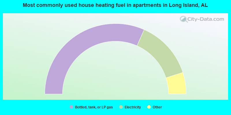
- 63.3%Bottled, tank, or LP gas
- 26.8%Electricity
- 4.0%Wood
- 3.7%Utility gas
- 2.3%Fuel oil, kerosene, etc.
Long Island compared to Alabama state average:
- Median house value below state average.
- Unemployed percentage significantly below state average.
- Black race population percentage significantly below state average.
- Hispanic race population percentage significantly below state average.
- Median age below state average.
- Foreign-born population percentage significantly below state average.
- Renting percentage below state average.
- Length of stay since moving in significantly above state average.
- Number of rooms per house significantly below state average.
- House age significantly below state average.
- Number of college students below state average.
- Percentage of population with a bachelor's degree or higher significantly below state average.
Long Island on our top lists:
- #2 on the list of "Top 101 cities with largest percentage of females in industries: music stores (population 5,000+)"
- #3 on the list of "Top 101 cities with largest percentage of females in industries: leather and allied products (population 5,000+)"
- #3 on the list of "Top 101 cities with largest percentage of males in industries: apparel (population 5,000+)"
- #3 on the list of "Top 101 cities with largest percentage of females in occupations: textile, apparel, and furnishings workers (population 5,000+)"
- #5 on the list of "Top 101 cities with largest percentage of females in industries: apparel (population 5,000+)"
- #5 on the list of "Top 101 cities with largest percentage of males in occupations: textile, apparel, and furnishings workers (population 5,000+)"
- #11 on the list of "Top 101 cities with largest percentage of females in occupations: carpenters (population 5,000+)"
- #11 on the list of "Top 101 cities with largest percentage of females in industries: textile mills and textile products (population 5,000+)"
- #19 on the list of "Top 101 cities with largest percentage of males in industries: textile mills and textile products (population 5,000+)"
- #20 on the list of "Top 101 cities with largest percentage of males in industries: repair and maintenance (population 5,000+)"
- #24 on the list of "Top 101 cities with largest percentage of males in occupations: electrical equipment mechanics and other installation, maintenance, and repair occupations including supervisors (population 5,000+)"
- #25 on the list of "Top 101 cities with largest percentage of males in occupations: material moving workers except supervisors and laborers and material movers, hand (population 5,000+)"
- #25 on the list of "Top 101 cities with largest percentage of females in industries: truck transportation (population 5,000+)"
- #29 on the list of "Top 101 cities with largest percentage of females in occupations: financial clerks except bookkeeping, accounting, and auditing clerks (population 5,000+)"
- #32 on the list of "Top 101 cities with largest percentage of males in industries: petroleum and coal products (population 5,000+)"
- #32 on the list of "Top 101 cities with largest percentage of males in industries: metal and metal products (population 5,000+)"
- #32 on the list of "Top 101 cities with largest percentage of females in industries: furniture and related product manufacturing (population 5,000+)"
- #46 on the list of "Top 101 cities with the least people having Master's or Doctorate degrees (population 5,000+)"
- #47 on the list of "Top 101 cities with largest percentage of females in industries: private households (population 5,000+)"
- #48 on the list of "Top 101 cities with largest percentage of males in industries: farm supplies merchant wholesalers (population 5,000+)"
- #16 on the list of "Top 101 counties with the largest increase in the number of deaths per 1000 residents 2000-2006 to 2007-2013 (pop. 50,000+)"
- #40 on the list of "Top 101 counties with the highest number of deaths per 1000 residents 2007-2013 (pop. 50,000+)"
- #76 on the list of "Top 101 counties with the smallest number of children under 18 without health insurance coverage in 2000 (pop. 50,000+)"
- #84 on the list of "Top 101 counties with the lowest percentage of residents relocating to other counties in 2011 (pop. 50,000+)"
- #96 on the list of "Top 101 counties with highest percentage of residents voting for Romney (Republican) in the 2012 Presidential Election (pop. 50,000+)"