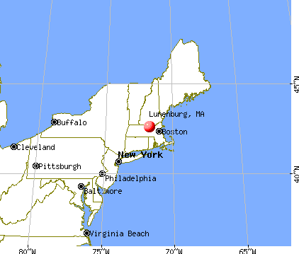
Lunenburg, Massachusetts
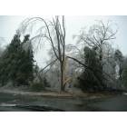
Submit your own pictures of this place and show them to the world
- OSM Map
- General Map
- Google Map
- MSN Map
Population change since 2000: +3.8%
| Males: 816 | |
| Females: 944 |
| Median resident age: | 41.3 years |
| Massachusetts median age: | 40.3 years |
Zip codes: 01462.
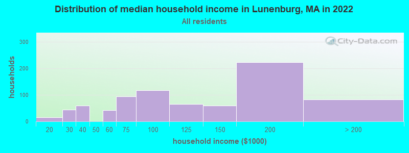
| Lunenburg: | $111,569 |
| MA: | $94,488 |
Estimated per capita income in 2022: $46,127 (it was $31,759 in 2000)
Lunenburg CDP income, earnings, and wages data
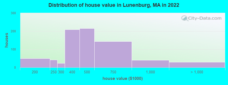
Estimated median house or condo value in 2022: $430,773 (it was $160,900 in 2000)
| Lunenburg: | $430,773 |
| MA: | $534,700 |
Mean prices in 2022: all housing units: $448,158; detached houses: $456,458; in 3-to-4-unit structures: $476,595
Detailed information about poverty and poor residents in Lunenburg, MA


Compare current foreclosures near Lunenburg, MA:
| Photo | Address | Area | Beds / Baths | Price | Details |
|---|---|---|---|---|---|

|
#1
Hemlock Dr
Lunenburg, MA 01462
|
696 sq. feet
|
1 baths 2 beds |
show details | |

|
#2
Whalom Rd
Lunenburg, MA 01462
|
1,090 sq. feet
|
1 baths 2 beds |
show details | |

|
#3
New West Townsend Rd
Lunenburg, MA 01462
|
1,270 sq. feet
|
1 baths 4 beds |
show details | |

|
#4
W Street Ter
Lunenburg, MA 01462
|
1,232 sq. feet
|
1 baths 2 beds |
show details | |

|
#5
Page St
Lunenburg, MA 01462
|
1,764 sq. feet
|
2 baths 3 beds |
show details | |

|
#6
Electric Ave
Lunenburg, MA 01462
|
872 sq. feet
|
1 baths 2 beds |
show details | |

|
#7
Florence St
Lunenburg, MA 01462
|
1,560 sq. feet
|
1 baths 2 beds |
show details | |

|
#8
Leominster Rd
Lunenburg, MA 01462
|
1,195 sq. feet
|
2 baths 3 beds |
show details | |

|
#9
Hollis Rd
Lunenburg, MA 01462
|
1,520 sq. feet
|
1 baths 3 beds |
show details | |

|
#10
White St
Lunenburg, MA 01462
|
1,158 sq. feet
|
1 baths 2 beds |
show details |
| Photo | Address | Area | Beds / Baths | Price | Details |
|---|---|---|---|---|---|

|
#11
Carousel Ln
Lunenburg, MA 01462
|
- sq. feet
|
- baths - beds |
show details | |

|
#12
Rogers Way, Unit 304
Lunenburg, MA 01462
|
- sq. feet
|
- baths - beds |
show details | |

|
#13
Tri Town Dr # N403
Lunenburg, MA 01462
|
- sq. feet
|
- baths - beds |
show details | |

|
#14
Goodrich St
Lunenburg, MA 01462
|
- sq. feet
|
- baths - beds |
show details | |

|
#15
Pearl Hill Rd
Fitchburg, MA 01420
|
2,152 sq. feet
|
2 baths 3 beds |
$529,900
|
show details |

|
#16
Sylvan Ave
Leominster, MA 01453
|
720 sq. feet
|
1 baths 2 beds |
$375,000
|
show details |

|
#17
Iriquois Dr
Ashburnham, MA 01430
|
2,016 sq. feet
|
2 baths 3 beds |
$369,000
|
show details |

|
#18
Parker St
Gardner, MA 01440
|
1,980 sq. feet
|
2 baths 4 beds |
$469,900
|
show details |

|
#19
Graham St
Leominster, MA 01453
|
1,036 sq. feet
|
1 baths 3 beds |
$485,000
|
show details |

|
#20
Great Rd
Shirley, MA 01464
|
1,672 sq. feet
|
1 baths 2 beds |
$464,900
|
show details |
| Photo | Address | Area | Beds / Baths | Price | Details |
|---|---|---|---|---|---|

|
#21
Nashua St
Milford, NH 03055
|
2,172 sq. feet
|
2 baths 4 beds |
show details | |

|
#22
Reagan Rd
Townsend, MA 01469
|
1,591 sq. feet
|
2 baths 3 beds |
show details | |

|
#23
West Rd
Ashby, MA 01431
|
7,000 sq. feet
|
3 baths 10 beds |
show details | |

|
#24
Mallard Drive, Unit 59 Coggshall Crossing Condominium
Fitchburg, MA 01420
|
1,306 sq. feet
|
1 baths 2 beds |
show details | |

|
#25
Grove Ave
Leominster, MA 01453
|
3,097 sq. feet
|
1 baths 4 beds |
show details | |

|
#26
Sugar Rd
Bolton, MA 01740
|
1,988 sq. feet
|
2 baths 3 beds |
show details | |

|
#27
Stone St
Gardner, MA 01440
|
1,908 sq. feet
|
2 baths 3 beds |
show details | |

|
#28
Chelsea St
Gardner, MA 01440
|
1,404 sq. feet
|
2 baths 3 beds |
show details | |

|
#29
Main St
Dunstable, MA 01827
|
2,452 sq. feet
|
2 baths 3 beds |
show details | |

|
#30
Vermont Rd
Tyngsboro, MA 01879
|
1,944 sq. feet
|
2 baths 4 beds |
show details |
| Photo | Address | Area | Beds / Baths | Price | Details |
|---|---|---|---|---|---|

|
#31
Prospect St
Gardner, MA 01440
|
1,357 sq. feet
|
2 baths 3 beds |
show details | |

|
#32
Bickford Hill Rd
Gardner, MA 01440
|
1,320 sq. feet
|
2 baths 3 beds |
show details | |

|
#33
Worcester Rd
Princeton, MA 01541
|
2,093 sq. feet
|
2 baths 4 beds |
show details | |

|
#34
Linwood St
Gardner, MA 01440
|
900 sq. feet
|
1 baths 3 beds |
show details | |

|
#35
Whitney St
Gardner, MA 01440
|
2,026 sq. feet
|
2 baths 3 beds |
show details | |

|
#36
Coal Kiln Rd
Princeton, MA 01541
|
1,588 sq. feet
|
2 baths 3 beds |
show details | |

|
#37
Summer St
Gardner, MA 01440
|
1,893 sq. feet
|
2 baths 5 beds |
show details | |

|
#38
Lakewood Ter
Gardner, MA 01440
|
3,143 sq. feet
|
4 baths 5 beds |
show details | |

|
#39
Oak Hill Ave
Clinton, MA 01510
|
1,248 sq. feet
|
1 baths 3 beds |
show details | |

|
#40
Edgell St
Gardner, MA 01440
|
4,746 sq. feet
|
2 baths 9 beds |
show details |
| Photo | Address | Area | Beds / Baths | Price | Details |
|---|---|---|---|---|---|

|
#41
Travers St
Gardner, MA 01440
|
660 sq. feet
|
1 baths 1 beds |
show details | |

|
#42
Green St
Gardner, MA 01440
|
3,156 sq. feet
|
2 baths 4 beds |
show details | |

|
#43
Mill St
Gardner, MA 01440
|
1,728 sq. feet
|
1 baths 4 beds |
show details | |

|
#44
Chelsea St
Gardner, MA 01440
|
1,498 sq. feet
|
1 baths 3 beds |
show details | |

|
#45
Pearly Ln
Gardner, MA 01440
|
1,728 sq. feet
|
2 baths 4 beds |
show details | |

|
#46
Mill St
Greenville, NH 03048
|
1,201 sq. feet
|
2 baths 2 beds |
show details | |

|
#47
Malderelli Rd
Greenville, NH 03048
|
1,098 sq. feet
|
1 baths 3 beds |
show details | |

|
#48
Cheyenne Rd
Pepperell, MA 01463
|
1,728 sq. feet
|
2 baths 4 beds |
show details | |

|
#49
Burbank Ln
Lancaster, MA 01523
|
1,848 sq. feet
|
2 baths 2 beds |
show details | |

|
Check over 1 million property listings on Foreclosure.com!
|
browse all offers | |||


- 1,76381.7%White alone
- 24711.4%Two or more races
- 823.8%Black alone
- 502.3%Asian alone
- 331.5%Hispanic
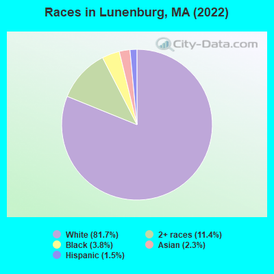
Races in Lunenburg detailed stats: ancestries, foreign born residents, place of birth
According to our research of Massachusetts and other state lists, there were 6 registered sex offenders living in Lunenburg, Massachusetts as of May 20, 2024.
The ratio of all residents to sex offenders in Lunenburg is 340 to 1.
Type |
2009 |
2010 |
2011 |
2012 |
2013 |
2014 |
2015 |
2016 |
2017 |
2018 |
2019 |
2020 |
2021 |
2022 |
|---|---|---|---|---|---|---|---|---|---|---|---|---|---|---|
| Murders (per 100,000) | 0 (0.0) | 0 (0.0) | 0 (0.0) | 0 (0.0) | 0 (0.0) | 0 (0.0) | 0 (0.0) | 0 (0.0) | 0 (0.0) | 0 (0.0) | 0 (0.0) | 0 (0.0) | 0 (0.0) | 0 (0.0) |
| Rapes (per 100,000) | 2 (19.8) | 0 (0.0) | 0 (0.0) | 1 (9.8) | 5 (44.8) | 2 (17.8) | 3 (26.4) | 5 (43.7) | 5 (43.6) | 3 (26.1) | 5 (42.4) | 2 (16.8) | 1 (8.3) | 5 (42.0) |
| Robberies (per 100,000) | 0 (0.0) | 2 (19.8) | 2 (19.7) | 1 (9.8) | 1 (9.0) | 4 (35.6) | 2 (17.6) | 4 (35.0) | 0 (0.0) | 0 (0.0) | 4 (34.0) | 0 (0.0) | 0 (0.0) | 2 (16.8) |
| Assaults (per 100,000) | 27 (267.7) | 15 (148.7) | 27 (266.1) | 25 (244.8) | 16 (143.5) | 14 (124.6) | 17 (149.3) | 22 (192.3) | 20 (174.3) | 15 (130.5) | 15 (127.3) | 22 (185.3) | 8 (66.1) | 13 (109.2) |
| Burglaries (per 100,000) | 38 (376.7) | 86 (852.7) | 59 (581.5) | 51 (499.4) | 62 (556.1) | 59 (525.0) | 59 (518.3) | 31 (271.0) | 36 (313.7) | 30 (260.9) | 13 (110.3) | 11 (92.6) | 17 (140.5) | 6 (50.4) |
| Thefts (per 100,000) | 118 (1,170) | 161 (1,596) | 207 (2,040) | 167 (1,635) | 145 (1,301) | 228 (2,029) | 274 (2,407) | 172 (1,504) | 115 (1,002) | 144 (1,252) | 115 (976.1) | 71 (597.9) | 75 (619.9) | 65 (546.1) |
| Auto thefts (per 100,000) | 2 (19.8) | 8 (79.3) | 6 (59.1) | 9 (88.1) | 3 (26.9) | 6 (53.4) | 7 (61.5) | 7 (61.2) | 8 (69.7) | 6 (52.2) | 0 (0.0) | 8 (67.4) | 10 (82.7) | 4 (33.6) |
| Arson (per 100,000) | 0 (0.0) | 0 (0.0) | 0 (0.0) | 0 (0.0) | 0 (0.0) | 0 (0.0) | 0 (0.0) | 1 (8.7) | 1 (8.7) | 0 (0.0) | 0 (0.0) | 0 (0.0) | 0 (0.0) | 0 (0.0) |
| City-Data.com crime index | 144.1 | 165.6 | 186.2 | 167.2 | 160.4 | 172.0 | 193.7 | 167.9 | 137.3 | 119.5 | 116.4 | 86.3 | 61.1 | 88.5 |
The City-Data.com crime index weighs serious crimes and violent crimes more heavily. Higher means more crime, U.S. average is 246.1. It adjusts for the number of visitors and daily workers commuting into cities.
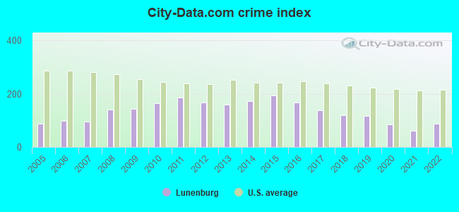
Crime rate in Lunenburg detailed stats: murders, rapes, robberies, assaults, burglaries, thefts, arson
Full-time law enforcement employees in 2021, including police officers: 18 (17 officers - 17 male; 0 female).
| Officers per 1,000 residents here: | 1.41 |
| Massachusetts average: | 2.53 |
 Recent articles from our blog. Our writers, many of them Ph.D. graduates or candidates, create easy-to-read articles on a wide variety of topics.


Latest news from Lunenburg, MA collected exclusively by city-data.com from local newspapers, TV, and radio stations
Ancestries: French Canadian (18.4%), Italian (14.7%), Irish (14.1%), American (10.8%), English (9.4%), European (6.4%).
Current Local Time: EST time zone
Incorporated in 1728
Elevation: 510 feet
Land area: 3.82 square miles.
Population density: 461 people per square mile (low).
184 residents are foreign born (4.9% Europe, 2.8% Asia).
| This place: | 8.5% |
| Massachusetts: | 17.6% |
Median real estate property taxes paid for housing units with mortgages in 2022: $5,955 (1.5%)
Median real estate property taxes paid for housing units with no mortgage in 2022: $6,665 (1.3%)
Nearest city with pop. 50,000+: Nashua, NH  (16.4 miles , pop. 86,605).
Nearest city with pop. 200,000+: Boston, MA (37.5 miles , pop. 589,141).
Nearest city with pop. 1,000,000+: Bronx, NY (164.1 miles , pop. 1,332,650).
Nearest cities:
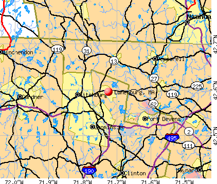
), ), ), Latitude: 42.60 N, Longitude: 71.72 W
Area code: 978
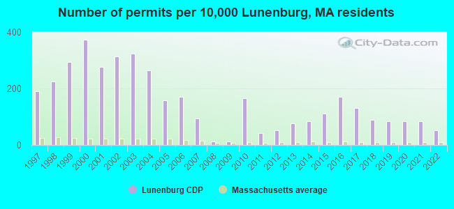
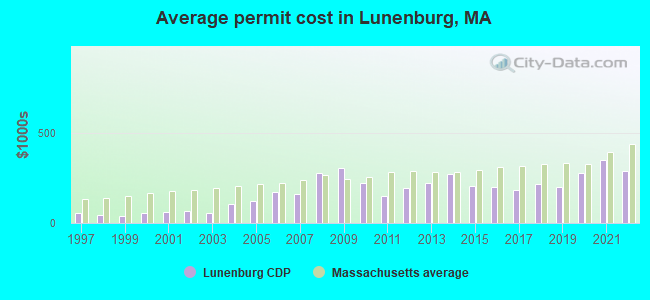
Single-family new house construction building permits:
- 2022: 9 buildings, average cost: $286,700
- 2021: 14 buildings, average cost: $346,300
- 2020: 14 buildings, average cost: $277,100
- 2019: 14 buildings, average cost: $199,800
- 2018: 15 buildings, average cost: $214,300
- 2017: 22 buildings, average cost: $182,900
- 2016: 29 buildings, average cost: $196,800
- 2015: 19 buildings, average cost: $202,200
- 2014: 14 buildings, average cost: $271,100
- 2013: 13 buildings, average cost: $220,200
- 2012: 9 buildings, average cost: $193,900
- 2011: 7 buildings, average cost: $147,100
- 2010: 28 buildings, average cost: $219,400
- 2009: 2 buildings, average cost: $305,000
- 2008: 2 buildings, average cost: $275,000
- 2007: 16 buildings, average cost: $159,400
- 2006: 29 buildings, average cost: $171,600
- 2005: 27 buildings, average cost: $119,300
- 2004: 45 buildings, average cost: $104,400
- 2003: 55 buildings, average cost: $52,700
- 2002: 53 buildings, average cost: $68,900
- 2001: 47 buildings, average cost: $61,700
- 2000: 63 buildings, average cost: $55,600
- 1999: 50 buildings, average cost: $40,300
- 1998: 38 buildings, average cost: $43,600
- 1997: 32 buildings, average cost: $58,400
| Here: | 3.6% |
| Massachusetts: | 3.5% |
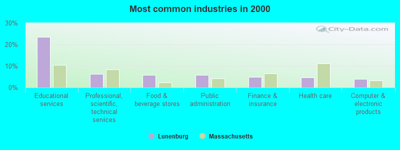
- Educational services (23.4%)
- Professional, scientific, technical services (6.4%)
- Food & beverage stores (5.8%)
- Public administration (5.8%)
- Finance & insurance (4.9%)
- Health care (4.7%)
- Computer & electronic products (4.0%)
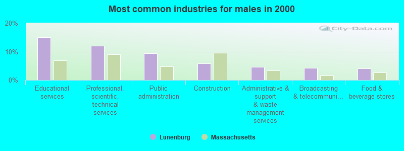
- Educational services (15.0%)
- Professional, scientific, technical services (12.1%)
- Public administration (9.3%)
- Construction (5.9%)
- Administrative & support & waste management services (4.6%)
- Broadcasting & telecommunications (4.3%)
- Food & beverage stores (4.1%)
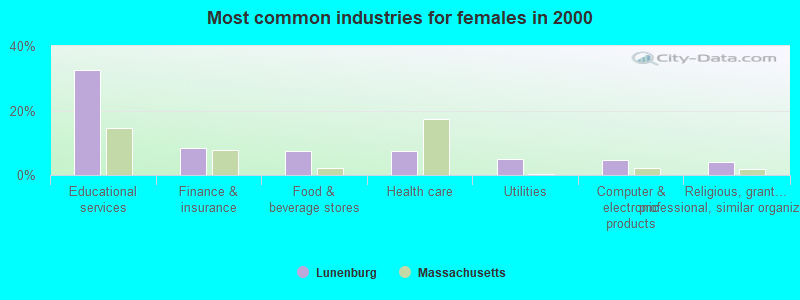
- Educational services (32.7%)
- Finance & insurance (8.4%)
- Food & beverage stores (7.6%)
- Health care (7.3%)
- Utilities (4.8%)
- Computer & electronic products (4.6%)
- Religious, grantmaking, civic, professional, similar organizations (4.1%)
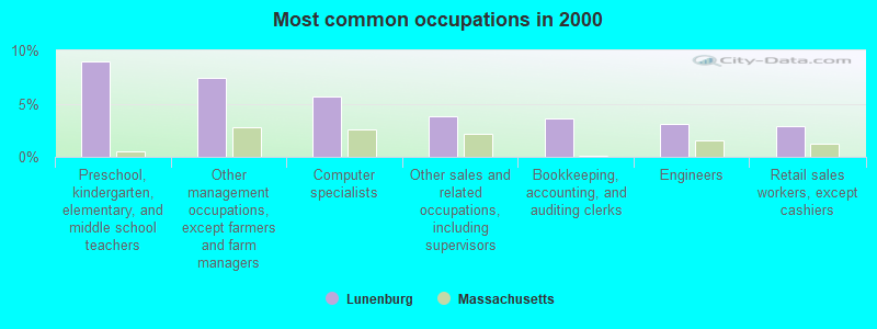
- Preschool, kindergarten, elementary, and middle school teachers (9.0%)
- Other management occupations, except farmers and farm managers (7.4%)
- Computer specialists (5.6%)
- Other sales and related occupations, including supervisors (3.8%)
- Bookkeeping, accounting, and auditing clerks (3.6%)
- Engineers (3.1%)
- Retail sales workers, except cashiers (2.9%)
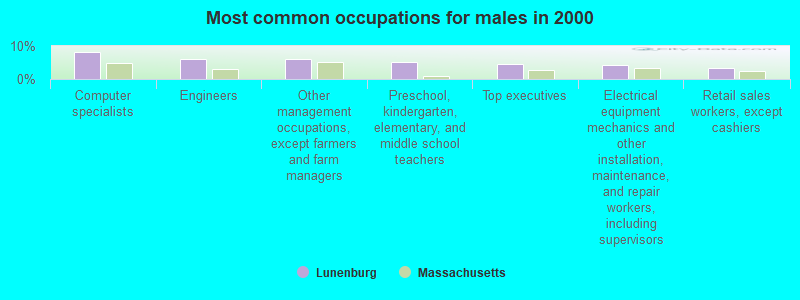
- Computer specialists (8.2%)
- Engineers (5.9%)
- Other management occupations, except farmers and farm managers (5.9%)
- Preschool, kindergarten, elementary, and middle school teachers (5.2%)
- Top executives (4.6%)
- Electrical equipment mechanics and other installation, maintenance, and repair workers, including supervisors (4.3%)
- Retail sales workers, except cashiers (3.4%)

- Preschool, kindergarten, elementary, and middle school teachers (13.2%)
- Other management occupations, except farmers and farm managers (9.1%)
- Other sales and related occupations, including supervisors (6.1%)
- Bookkeeping, accounting, and auditing clerks (5.8%)
- Secretaries and administrative assistants (5.8%)
- Other teachers, instructors, education, training, and library occupations (5.6%)
- Nursing, psychiatric, and home health aides (5.3%)
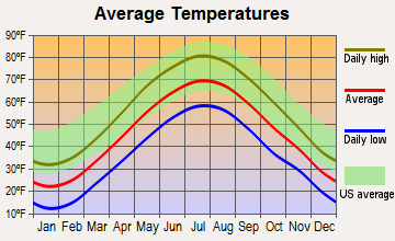
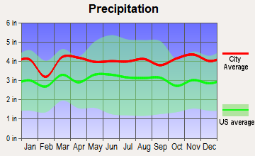
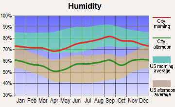
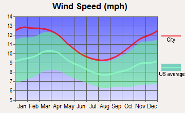
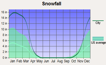
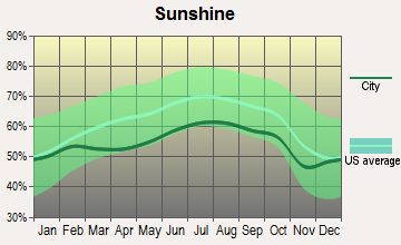
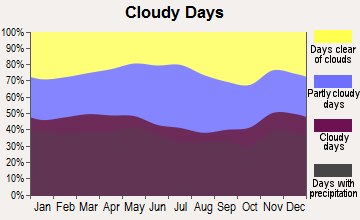
Average climate in Lunenburg, Massachusetts
Based on data reported by over 4,000 weather stations
(lower is better)
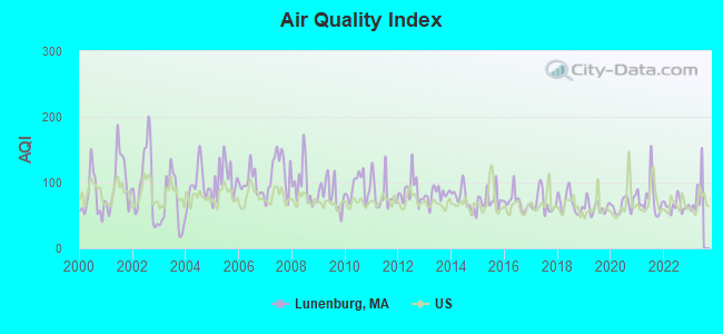
Air Quality Index (AQI) level in 2022 was 64.8. This is about average.
| City: | 64.8 |
| U.S.: | 72.6 |
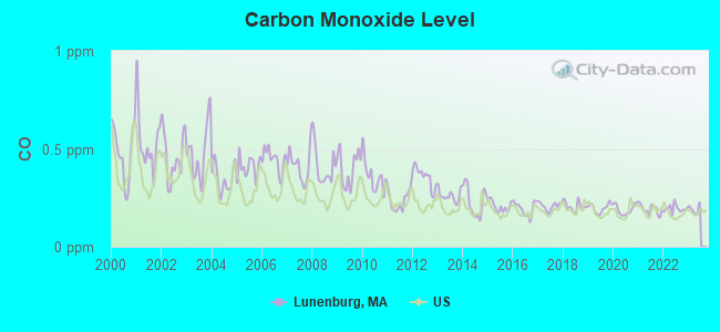
Carbon Monoxide (CO) [ppm] level in 2022 was 0.195. This is better than average. Closest monitor was 17.2 miles away from the city center.
| City: | 0.195 |
| U.S.: | 0.251 |
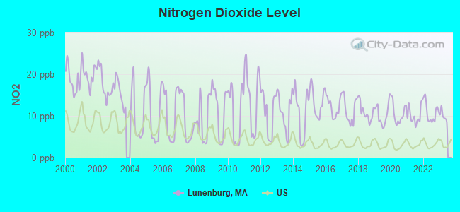
Nitrogen Dioxide (NO2) [ppb] level in 2022 was 10.9. This is significantly worse than average. Closest monitor was 3.4 miles away from the city center.
| City: | 10.9 |
| U.S.: | 5.1 |
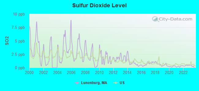
Sulfur Dioxide (SO2) [ppb] level in 2022 was 0.381. This is significantly better than average. Closest monitor was 2.9 miles away from the city center.
| City: | 0.381 |
| U.S.: | 1.515 |
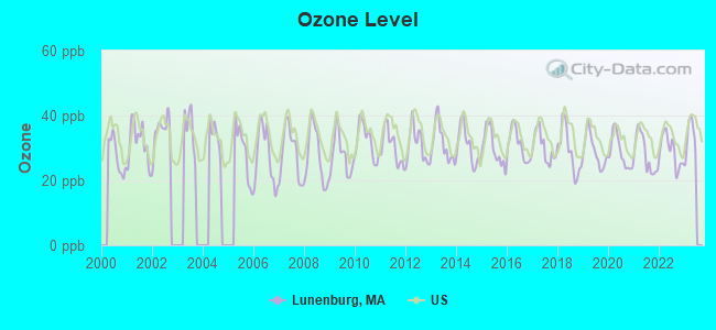
Ozone [ppb] level in 2022 was 29.1. This is about average. Closest monitor was 3.4 miles away from the city center.
| City: | 29.1 |
| U.S.: | 33.3 |
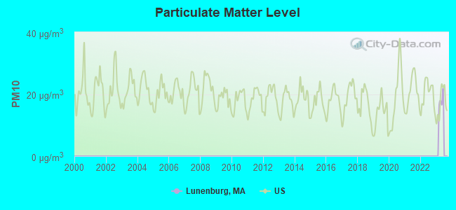
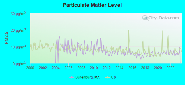
Particulate Matter (PM2.5) [µg/m3] level in 2022 was 6.13. This is better than average. Closest monitor was 3.3 miles away from the city center.
| City: | 6.13 |
| U.S.: | 8.11 |
Tornado activity:
Lunenburg-area historical tornado activity is slightly above Massachusetts state average. It is 22% smaller than the overall U.S. average.
On 6/9/1953, a category F4 (max. wind speeds 207-260 mph) tornado 22.9 miles away from the Lunenburg place center killed 90 people and injured 1228 people and caused between $50,000,000 and $500,000,000 in damages.
On 6/22/1981, a category F3 (max. wind speeds 158-206 mph) tornado 9.5 miles away from the place center injured 3 people and caused between $5000 and $50,000 in damages.
Earthquake activity:
Lunenburg-area historical earthquake activity is significantly above Massachusetts state average. It is 71% smaller than the overall U.S. average.On 10/7/1983 at 10:18:46, a magnitude 5.3 (5.1 MB, 5.3 LG, 5.1 ML, Class: Moderate, Intensity: VI - VII) earthquake occurred 161.8 miles away from the city center
On 4/20/2002 at 10:50:47, a magnitude 5.3 (5.3 ML, Depth: 3.0 mi) earthquake occurred 165.4 miles away from Lunenburg center
On 4/20/2002 at 10:50:47, a magnitude 5.2 (5.2 MB, 4.2 MS, 5.2 MW, 5.0 MW) earthquake occurred 164.6 miles away from the city center
On 1/19/1982 at 00:14:42, a magnitude 4.7 (4.5 MB, 4.7 MD, 4.5 LG, Class: Light, Intensity: IV - V) earthquake occurred 62.9 miles away from the city center
On 10/16/2012 at 23:12:25, a magnitude 4.7 (4.7 ML, Depth: 10.0 mi) earthquake occurred 87.9 miles away from Lunenburg center
On 10/2/1994 at 11:27:22, a magnitude 3.7 (3.5 LG, 3.7 LG, Depth: 6.2 mi, Class: Light, Intensity: II - III) earthquake occurred 33.0 miles away from Lunenburg center
Magnitude types: regional Lg-wave magnitude (LG), body-wave magnitude (MB), duration magnitude (MD), local magnitude (ML), surface-wave magnitude (MS), moment magnitude (MW)
Natural disasters:
The number of natural disasters in Worcester County (27) is a lot greater than the US average (15).Major Disasters (Presidential) Declared: 15
Emergencies Declared: 12
Causes of natural disasters: Floods: 9, Storms: 8, Hurricanes: 6, Snowstorms: 5, Winter Storms: 4, Blizzards: 2, Snows: 2, Fire: 1, Heavy Rain: 1, Snowfall: 1, Tornado: 1, Wind: 1 (Note: some incidents may be assigned to more than one category).
Hospitals and medical centers near Lunenburg:
- KEYSTONE CENTER (Nursing Home, about 4 miles away; LEOMINSTER, MA)
- BIRCHWOOD MANOR NURS HOME (Nursing Home, about 4 miles away; FITCHBURG, MA)
- GOLDEN LIVING CENTER-FITCHBURG (Nursing Home, about 4 miles away; FITCHBURG, MA)
- HEALTHALLIANCE HOME HEALTH AND HOSPICE (Home Health Center, about 4 miles away; LEOMINSTER, MA)
- DIVERSIFIED HOME SERVICES HOSPICE PROGRAM (Hospital, about 4 miles away; LEOMINSTER, MA)
- HILLCREST NURSING HOME (Nursing Home, about 4 miles away; FITCHBURG, MA)
- KINDRED NURSING AND REHABILITATION-HILLCREST (Nursing Home, about 4 miles away; FITCHBURG, MA)
Colleges/universities with over 2000 students nearest to Lunenburg:
- Fitchburg State University (about 4 miles; Fitchburg, MA; Full-time enrollment: 5,010)
- Mount Wachusett Community College (about 14 miles; Gardner, MA; FT enrollment: 3,143)
- Quinsigamond Community College (about 20 miles; Worcester, MA; FT enrollment: 5,877)
- University of Massachusetts-Lowell (about 21 miles; Lowell, MA; FT enrollment: 12,341)
- Franklin Pierce University (about 22 miles; Rindge, NH; FT enrollment: 2,139)
- Assumption College (about 22 miles; Worcester, MA; FT enrollment: 2,580)
- Worcester Polytechnic Institute (about 23 miles; Worcester, MA; FT enrollment: 3,930)
Public high school in Lunenburg:
- LUNENBURG HIGH (Students: 634, Location: 1079 MASSACHUSETTS AVENUE, Grades: 8-12)
Private high school in Lunenburg:
Public elementary/middle schools in Lunenburg:
- TURKEY HILL MIDDLE (Students: 417, Location: 129 NORTHFIELD ROAD, Grades: 4-7)
- LUNENBURG PRIMARY SCHOOL (Location: 1401 MASSACHUSETTS AVENUE, Grades: PK-3)
Points of interest:
Notable locations in Lunenburg: Lanni Orchards (A), Lunenburg Fire Department (B), Lunenburg High School Library (C), Ritter Memorial Library (D). Display/hide their locations on the map
Churches in Lunenburg include: Saint Bonaface Church (A), Pilgrim Convenant Church (B), Lunenburg United Parish House (C). Display/hide their locations on the map
Cemetery: North Cemetery (1). Display/hide its location on the map
Lake: Turkey Hill Pond (A). Display/hide its location on the map
Parks in Lunenburg include: Marshall Park (1), Lunenburg Historic District (2). Display/hide their locations on the map
Birthplace of: Susannah Willard Johnson - Captive of Native s and author of a captivity narrative, William Austin (author) - Politician, David Pelletier (American figure skater) - Figure skater, Frederick Cushing Cross, Jr. - Soilder.
Drinking water stations with addresses in Lunenburg and their reported violations in the past:
LUNENBURG WATER DISTRICT (Population served: 6,357, Groundwater):Past health violations:GREEN VALLEY MOBILE HOME PARK (Serves NH, Population served: 115, Groundwater):
- MCL, Monthly (TCR) - In JUL-2008, Contaminant: Coliform. Follow-up actions: St AO (w/o penalty) issued (AUG-19-2008), St Compliance achieved (AUG-19-2008)
Past monitoring violations:FAIRHAVEN MOBILE HOME PARK (Serves NH, Population served: 63, Groundwater):
- One routine major monitoring violation
Past health violations:Past monitoring violations:
- MCL, Acute (TCR) - In SEP-2006, Contaminant: Coliform. Follow-up actions: St Public Notif requested (SEP-11-2006), St Violation/Reminder Notice (SEP-11-2006), St Public Notif received (SEP-25-2006), St Compliance achieved (MAR-30-2007)
- Monitoring, Repeat Major (TCR) - In JUL-2008, Contaminant: Coliform (TCR). Follow-up actions: St Public Notif requested (SEP-26-2008), St Violation/Reminder Notice (SEP-26-2008), St Public Notif received (OCT-16-2008), St Compliance achieved (FEB-09-2009)
- One routine major monitoring violation
- One regular monitoring violation
| This place: | 2.6 people |
| Massachusetts: | 2.5 people |
| This place: | 75.4% |
| Whole state: | 63.0% |
| This place: | 7.2% |
| Whole state: | 7.0% |
Likely homosexual households (counted as self-reported same-sex unmarried-partner households)
- Lesbian couples: 0.3% of all households
- Gay men: 0.6% of all households
3 people in agriculture workers' dormitories on farms in 2000
Banks with branches in Lunenburg (2011 data):
- North Middlesex Savings Bank: Lunenburg Branch at 947 Massachusetts Avenue Branch, branch established on 2003/06/04. Info updated 2006/11/03: Bank assets: $329.3 mil, Deposits: $268.7 mil, headquarters in Ayer, MA, positive income, Commercial Lending Specialization, 7 total offices
For population 15 years and over in Lunenburg:
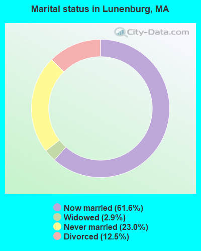
- Never married: 23.0%
- Now married: 61.6%
- Separated: 0.0%
- Widowed: 2.9%
- Divorced: 12.5%
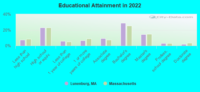
For population 25 years and over in Lunenburg:
- High school or higher: 93.4%
- Bachelor's degree or higher: 49.0%
- Graduate or professional degree: 19.4%
- Unemployed: 3.9%
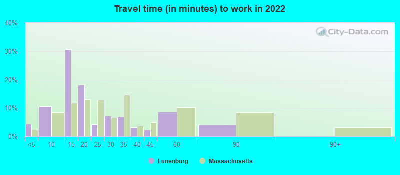
- Mean travel time to work (commute): 31.9 minutes
| Here: | 12.3 |
| Massachusetts average: | 13.0 |


Graphs represent county-level data. Detailed 2008 Election Results
Religion statistics for Lunenburg, MA (based on Worcester County data)


| Religion | Adherents | Congregations |
|---|---|---|
| Catholic | 306,925 | 118 |
| Mainline Protestant | 43,326 | 171 |
| Evangelical Protestant | 37,511 | 203 |
| Other | 18,931 | 69 |
| Orthodox | 7,935 | 15 |
| Black Protestant | 497 | 6 |
| None | 383,427 | - |
Food Environment Statistics:
| Here: | 1.73 / 10,000 pop. |
| Massachusetts: | 1.98 / 10,000 pop. |
| Here: | 0.05 / 10,000 pop. |
| State: | 0.05 / 10,000 pop. |
| Worcester County: | 1.79 / 10,000 pop. |
| State: | 2.22 / 10,000 pop. |
| Worcester County: | 2.22 / 10,000 pop. |
| Massachusetts: | 1.77 / 10,000 pop. |
| Worcester County: | 7.27 / 10,000 pop. |
| Massachusetts: | 8.76 / 10,000 pop. |
| This county: | 8.0% |
| State: | 8.1% |
| This county: | 24.0% |
| Massachusetts: | 22.5% |
| Worcester County: | 16.6% |
| Massachusetts: | 16.5% |
Health and Nutrition:
| This city: | 50.7% |
| State: | 50.5% |
| Lunenburg: | 51.0% |
| State: | 48.0% |
| Lunenburg: | 27.5 |
| Massachusetts: | 28.4 |
| Here: | 13.3% |
| Massachusetts: | 20.7% |
| Lunenburg: | 11.4% |
| State: | 10.4% |
| This city: | 6.8 |
| Massachusetts: | 6.8 |
| Lunenburg: | 26.0% |
| Massachusetts: | 33.4% |
| Here: | 61.1% |
| Massachusetts: | 57.1% |
| Here: | 85.6% |
| Massachusetts: | 79.2% |
More about Health and Nutrition of Lunenburg, MA Residents
4.71% of this county's 2021 resident taxpayers lived in other counties in 2020 ($76,229 average adjusted gross income)
| Here: | 4.71% |
| Massachusetts average: | 6.35% |
0.02% of residents moved from foreign countries ($100 average AGI)
Worcester County: 0.02% Massachusetts average: 0.01%
Top counties from which taxpayers relocated into this county between 2020 and 2021:
| from Middlesex County, MA | |
| from Norfolk County, MA | |
| from Suffolk County, MA |
4.84% of this county's 2020 resident taxpayers moved to other counties in 2021 ($87,252 average adjusted gross income)
| Here: | 4.84% |
| Massachusetts average: | 7.18% |
0.03% of residents moved to foreign countries ($199 average AGI)
Worcester County: 0.03% Massachusetts average: 0.02%
Top counties to which taxpayers relocated from this county between 2020 and 2021:
| to Middlesex County, MA | |
| to Norfolk County, MA | |
| to Suffolk County, MA |
| Businesses in Lunenburg, MA | ||||
| Name | Count | Name | Count | |
|---|---|---|---|---|
| CVS | 1 | Subaru | 1 | |
| Dunkin Donuts | 1 | T-Mobile | 1 | |
| Fashion Bug | 1 | True Value | 1 | |
| GameStop | 1 | UPS | 1 | |
| MasterBrand Cabinets | 5 | Walmart | 1 | |
| Mazda | 1 | |||
Strongest AM radio stations in Lunenburg:
- WEIM (1280 AM; 5 kW; FITCHBURG, MA; Owner: LIVEAIR COMMUNICATIONS, INC.)
- WRKO (680 AM; 50 kW; BOSTON, MA; Owner: ENTERCOM BOSTON LICENSE, LLC)
- WFGL (960 AM; 2 kW; FITCHBURG, MA; Owner: CSN INTERNATIONAL)
- WCRN (830 AM; 50 kW; WORCESTER, MA; Owner: CARTER BROADCASTING CORPORATION)
- WKOX (1200 AM; 50 kW; FRAMINGHAM, MA; Owner: CAPSTAR TX LIMITED PARTNERSHIP)
- WEEI (850 AM; 50 kW; BOSTON, MA; Owner: ENTERCOM BOSTON LICENSE, LLC)
- WBIX (1060 AM; 40 kW; NATICK, MA; Owner: LANGER BROADCASTING CORPORATION)
- WCMX (1000 AM; daytime; 1 kW; LEOMINSTER, MA; Owner: TWIN CITY BAPTIST TEMPLE, INC.)
- WWZN (1510 AM; 50 kW; BOSTON, MA; Owner: ROSE CITY RADIO CORPORATION)
- WVNE (760 AM; daytime; 25 kW; LEICESTER, MA; Owner: BLOUNT MASSCOM, INC.)
- WAMG (890 AM; 25 kW; DEDHAM, MA; Owner: MEGA COMMUNICATIONS OF DEDHAM LICENSEE, LLC)
- WALE (990 AM; 50 kW; GREENVILLE, RI; Owner: NORTH AMERICAN BROADCASTING CO., INC.)
- WTAG (580 AM; 5 kW; WORCESTER, MA; Owner: CAPSTAR TX LIMITED PARTNERSHIP)
Strongest FM radio stations in Lunenburg:
- WXLO (104.5 FM; FITCHBURG, MA; Owner: CITADEL BROADCASTING COMPANY)
- WFEX (92.1 FM; PETERBOROUGH, NH; Owner: FNX BROADCASTING OF NEW HAMPSHIRE LLC)
- WAAF (107.3 FM; WORCESTER, MA; Owner: ENTERCOM BOSTON LICENSE, LLC)
- WSRS (96.1 FM; WORCESTER, MA; Owner: CAPSTAR TX LIMITED PARTNERSHIP)
- WGIR-FM (101.1 FM; MANCHESTER, NH; Owner: CAPSTAR TX LIMITED PARTNERSHIP)
- WQLL (96.5 FM; BEDFORD, NH; Owner: SAGA COMMUNICATIONS OF NEW ENGLAND, LLC)
- WBMX (98.5 FM; BOSTON, MA; Owner: INFINITY RADIO OPERATIONS INC.)
- WLMW (90.7 FM; MANCHESTER, NH; Owner: KNOWLEDGE FOR LIFE)
- WJMN (94.5 FM; BOSTON, MA; Owner: AMFM RADIO LICENSES, L.L.C.)
- WCRB (102.5 FM; WALTHAM, MA; Owner: CHARLES RIVER BROADCASTING WCRB LICE)
- WTKK (96.9 FM; BOSTON, MA; Owner: GREATER BOSTON RADIO, INC.)
- WROR-FM (105.7 FM; FRAMINGHAM, MA; Owner: GREATER BOSTON RADIO, INC.)
- WZID (95.7 FM; MANCHESTER, NH; Owner: SAGA COMMUNICATIONS OF NEW ENGLAND, LLC)
- WBOS (92.9 FM; BROOKLINE, MA; Owner: GREATER BOSTON RADIO, INC.)
- WGBH (89.7 FM; BOSTON, MA; Owner: WGBH EDUCATIONAL FOUNDATION)
- WHOB (106.3 FM; NASHUA, NH; Owner: TELE-MEDIA COMPANY OF NEW HAMPSHIRE, L.L.C.)
- WXKS-FM (107.9 FM; MEDFORD, MA; Owner: AMFM RADIO LICENSES, L.L.C.)
- WBUR-FM (90.9 FM; BOSTON, MA; Owner: TRUSTEES OF BOSTON UNIVERSITY)
- WINQ (97.7 FM; WINCHENDON, MA; Owner: SAGA COMMUNICATIONS OF NEW ENGLAND, LLC)
- WMJX (106.7 FM; BOSTON, MA; Owner: GREATER BOSTON RADIO, INC.)
TV broadcast stations around Lunenburg:
- WUNI (Channel 27; WORCESTER, MA; Owner: ENTRAVISION HOLDINGS, LLC)
- WUTF (Channel 66; MARLBOROUGH, MA; Owner: TELEFUTURA BOSTON LLC)
- WCVB-TV (Channel 5; BOSTON, MA; Owner: WCVB HEARST-ARGYLE TV, INC.)
- WGBH-TV (Channel 2; BOSTON, MA; Owner: WGBH EDUCATIONAL FOUNDATION)
- WHDH-TV (Channel 7; BOSTON, MA; Owner: WHDH-TV)
- WMFP (Channel 62; LAWRENCE, MA; Owner: WSAH LICENSE, INC.)
- WBZ-TV (Channel 4; BOSTON, MA; Owner: VIACOM INC.)
- WGBX-TV (Channel 44; BOSTON, MA; Owner: WGBH EDUCATIONAL FOUNDATION)
- WSBK-TV (Channel 38; BOSTON, MA; Owner: VIACOM INC.)
- WLVI-TV (Channel 56; CAMBRIDGE, MA; Owner: WLVI, INC.)
- WFXT (Channel 25; BOSTON, MA; Owner: FOX TELEVISION STATIONS INC.)
- WFXZ-CA (Channel 24; BOSTON, MA; Owner: BOSTON BROADCASTING CORP.)
- WNDS (Channel 50; DERRY, NH; Owner: CTV OF DERRY, INC)
- WYDN (Channel 48; WORCESTER, MA; Owner: EDUCATIONAL PUBLIC TV CORPORATION)
- W40BO (Channel 40; BOSTON, MA; Owner: PAXSON COMMUNICATIONS LPTV, INC.)
- WBPX (Channel 68; BOSTON, MA; Owner: PAXSON BOSTON-68 LICENSE, INC.)
- WTMU-LP (Channel 32; BOSTON, MA; Owner: ZGS BOSTON, INC.)
- WCEA-LP (Channel 58; BOSTON, MA; Owner: CHANNEL 19 TV CORPORATION)
- Lunenburg, Massachusetts
- Fatal accident count58
- Vehicles involved in fatal accidents77
- Fatal accidents involving drunk persons:29
- Fatalities65
- Persons involved in fatal accidents142
- Pedestrians involved in fatal accidents2
- Massachusetts average
- Fatal accident count16463
- Vehicles involved in fatal accidents22889
- Fatal accidents involving drunk persons5418
- Fatalities17740
- Persons involved in fatal accidents37704
- Pedestrians involved in fatal accidents1593
- National Bridge Inventory (NBI) Statistics
- 2Number of bridges
- 7ft / 1.5mTotal length
- $2,403,000Total costs
- 4,203Total average daily traffic
- 254Total average daily truck traffic
- 7,360Total future (year 2031) average daily traffic
FCC Registered Antenna Towers:
48 (See the full list of FCC Registered Antenna Towers in Lunenburg)FCC Registered Broadcast Land Mobile Towers:
3- 9 Chase Road (Lat: 42.598694 Lon: -71.754778), Type: Tank, Structure height: 30.5 m, Overall height: 36.9 m, Call Sign: WPYL783,
Assigned Frequencies: 470.375 MHz, Grant Date: 09/01/2023, Expiration Date: 09/04/2033, Certifier: Francis Mcnamara, Registrant: Lunenburg Water District, 496 Massachusetts Ave, Lunenburg, MA 01462, Phone: (978) 582-4532, Fax: (978) 582-4590, Email:
- Lat: 42.538611 Lon: -71.692500, Call Sign: WQAW318,
Assigned Frequencies: 469.075 MHz, Grant Date: 08/18/2004, Expiration Date: 08/18/2014, Cancellation Date: 10/18/2014, Certifier: Ed Silva, Registrant: Edwin L. Thompson & Son, Inc., 131 Stedman Street, Suite 1, Chelmsford, MA 01824, Phone: (978) 453-2444, Fax: (978) 453-4747
- 301 Massachusetts Ave. (Lat: 42.592278 Lon: -71.759194), Type: Bant, Structure height: 10.9 m, Overall height: 16.4 m, Call Sign: WQEA829,
Assigned Frequencies: 470.550 MHz, Grant Date: 09/22/2015, Expiration Date: 12/15/2025, Certifier: Brian F Belliveau, Registrant: Fitchburg Fire Department, 33 North Street, Fitchburg, MA 01420, Phone: (978) 345-9660, Email:
FCC Registered Microwave Towers:
5- 194 Electric Ave (Lat: 42.588417 Lon: -71.753667), Overall height: 22.9 m, Call Sign: WPJA645,
Assigned Frequencies: 947.500 MHz, Grant Date: 09/19/1995, Expiration Date: 04/01/2030, Phone: (508) 582-4901
- 194 Electric Ave (Lat: 42.588417 Lon: -71.753667), Overall height: 22.9 m, Call Sign: WPJF370,
Assigned Frequencies: 944.125 MHz, 944.375 MHz, Grant Date: 05/07/1996, Expiration Date: 04/01/2030, Phone: (617) 254-9267
- Lunenburg, Pope Road (Lat: 42.598556 Lon: -71.753972), Type: Tank, Structure height: 30.5 m, Overall height: 36.6 m, Call Sign: WPOL890,
Assigned Frequencies: 10642.5 MHz, Grant Date: 02/10/2009, Expiration Date: 04/01/2019, Cancellation Date: 05/04/2017, Certifier: Carol L Tacker, Registrant: At&t Mobility LLC, 5601 Legacy Drive, Ms: A-3, Plano, TX 75024, Phone: (469) 229-7471, Fax: (469) 229-7297, Email:
- WATERTANK, Pope Rd (Private Rd.) (Lat: 42.598528 Lon: -71.753889), Type: Tank, Structure height: 30.5 m, Call Sign: WQNY219,
Assigned Frequencies: 19495.0 MHz, Grant Date: 07/03/2021, Expiration Date: 07/05/2031, Certifier: Brian F Belliveau, Registrant: Cyber Communications, Inc, 250 Cape Highway, Route 44, East Taunton, MA 02718, Phone: (508) 880-3294, Fax: (508) 880-6745, Email:
- 4BZ0219B, 998 Reservior Road (Lat: 42.535750 Lon: -71.687722), Type: Mtower, Structure height: 46.3 m, Overall height: 48.8 m, Call Sign: WRAH713,
Assigned Frequencies: 11425.0 MHz, 11425.0 MHz, 11425.0 MHz, 11425.0 MHz, 11425.0 MHz, 11425.0 MHz, 11425.0 MHz, 11425.0 MHz, Grant Date: 11/21/2017, Expiration Date: 11/21/2027, Cancellation Date: 10/15/2018, Certifier: David Werblow, Registrant: T-Mobile Usa, Inc., 12920 Se 38th Street, Bellevue, WA 98006, Phone: (425) 383-8401, Fax: (425) 383-4040, Email:
FCC Registered Amateur Radio Licenses:
69 (See the full list of FCC Registered Amateur Radio Licenses in Lunenburg)FAA Registered Aircraft:
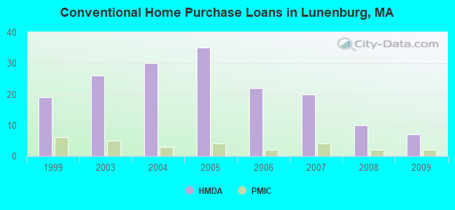
10 (See the full list of FAA Registered Aircraft in Lunenburg)| Home Mortgage Disclosure Act Aggregated Statistics For Year 2009 (Based on 2 partial tracts) | ||||||||||
| A) FHA, FSA/RHS & VA Home Purchase Loans | B) Conventional Home Purchase Loans | C) Refinancings | D) Home Improvement Loans | F) Non-occupant Loans on < 5 Family Dwellings (A B C & D) | ||||||
|---|---|---|---|---|---|---|---|---|---|---|
| Number | Average Value | Number | Average Value | Number | Average Value | Number | Average Value | Number | Average Value | |
| LOANS ORIGINATED | 6 | $211,007 | 7 | $231,630 | 49 | $209,006 | 4 | $84,552 | 2 | $127,615 |
| APPLICATIONS APPROVED, NOT ACCEPTED | 0 | $0 | 0 | $0 | 3 | $233,627 | 0 | $0 | 0 | $0 |
| APPLICATIONS DENIED | 1 | $271,730 | 1 | $272,510 | 14 | $237,662 | 1 | $39,540 | 1 | $110,620 |
| APPLICATIONS WITHDRAWN | 1 | $193,530 | 1 | $184,400 | 9 | $218,782 | 0 | $0 | 0 | $0 |
| FILES CLOSED FOR INCOMPLETENESS | 0 | $0 | 0 | $0 | 4 | $209,010 | 0 | $0 | 0 | $0 |
Detailed HMDA statistics for the following Tracts: 7121.01 , 7121.02
| Private Mortgage Insurance Companies Aggregated Statistics For Year 2009 (Based on 2 partial tracts) | ||||
| A) Conventional Home Purchase Loans | B) Refinancings | |||
|---|---|---|---|---|
| Number | Average Value | Number | Average Value | |
| LOANS ORIGINATED | 2 | $230,700 | 1 | $213,890 |
| APPLICATIONS APPROVED, NOT ACCEPTED | 1 | $139,000 | 0 | $0 |
| APPLICATIONS DENIED | 0 | $0 | 1 | $207,960 |
| APPLICATIONS WITHDRAWN | 0 | $0 | 0 | $0 |
| FILES CLOSED FOR INCOMPLETENESS | 0 | $0 | 0 | $0 |
Detailed PMIC statistics for the following Tracts: 7121.01 , 7121.02
2002 - 2018 National Fire Incident Reporting System (NFIRS) incidents
- Fire incident types reported to NFIRS in Lunenburg, MA
- 43956.4%Structure Fires
- 21928.1%Outside Fires
- 8210.5%Mobile Property/Vehicle Fires
- 395.0%Other
 According to the data from the years 2002 - 2018 the average number of fire incidents per year is 46. The highest number of fire incidents - 71 took place in 2006, and the least - 16 in 2002. The data has an increasing trend.
 When looking into fire subcategories, the most reports belonged to: Structure Fires (56.4%), and Outside Fires (28.1%).
- 67.6%Fuel oil, kerosene, etc.
- 13.6%Utility gas
- 9.9%Bottled, tank, or LP gas
- 7.5%Wood
- 1.4%Electricity
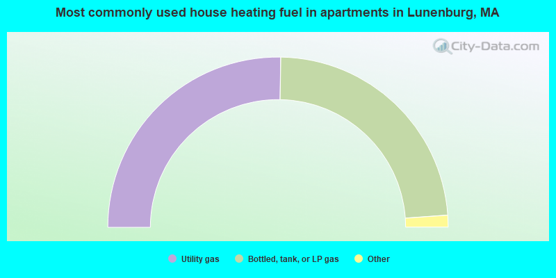
- 51.7%Utility gas
- 48.3%Bottled, tank, or LP gas
Lunenburg compared to Massachusetts state average:
- Unemployed percentage significantly below state average.
- Hispanic race population percentage significantly below state average.
- Median age above state average.
- Foreign-born population percentage below state average.
- Renting percentage significantly below state average.
Lunenburg on our top lists:
- #32 on the list of "Top 101 cities with the most residents born in Iran (population 500+)"
- #39 on the list of "Top 101 cities with the most residents born in Sweden (population 500+)"
- #4 on the list of "Top 101 counties with the highest carbon monoxide air pollution readings in 2012 (ppm)"
- #5 on the list of "Top 101 counties with the most Catholic congregations"
- #12 on the list of "Top 101 counties with the highest surface withdrawal of fresh water for public supply"
- #16 on the list of "Top 101 counties with the highest total withdrawal of fresh water for public supply"
- #23 on the list of "Top 101 counties with the highest Sulfur Oxides Annual air pollution readings in 2012 (µg/m3)"

|
|
Total of 238 patent applications in 2008-2024.