Malaga, Washington
Submit your own pictures of this place and show them to the world
- OSM Map
- General Map
- Google Map
- MSN Map
| Males: 1,917 | |
| Females: 1,798 |
| Median resident age: | 36.0 years |
| Washington median age: | 35.3 years |
Zip code: 98801
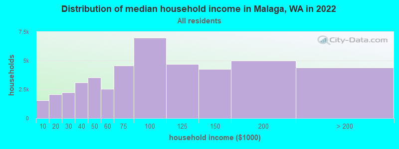
| Malaga: | $120,348 |
| WA: | $91,306 |
Estimated per capita income in 2022: $47,236 (it was $21,349 in 2000)
Malaga CCD income, earnings, and wages data
Estimated median house or condo value in 2022: $555,232 (it was $161,600 in 2000)
| Malaga: | $555,232 |
| WA: | $569,500 |
Mean prices in 2022: all housing units: $546,003; detached houses: $581,015; townhouses or other attached units: $870,036; in 2-unit structures: $555,465; in 3-to-4-unit structures: $383,882; in 5-or-more-unit structures: $249,076; mobile homes: $267,876; occupied boats, rvs, vans, etc.: $118,218
Detailed information about poverty and poor residents in Malaga, WA
Compare current foreclosures near Malaga, WA:
| Photo | Address | Area | Beds / Baths | Price | Details |
|---|---|---|---|---|---|

|
#1
Bermuda St
Malaga, WA 98828
|
1,040 sq. feet
|
1 baths 3 beds |
show details | |

|
#2
Malaga Alcoa Hwy
Malaga, WA 98828
|
- sq. feet
|
- baths - beds |
show details | |

|
#3
Malaga Alcoa Hwy
Malaga, WA 98828
|
- sq. feet
|
- baths - beds |
show details | |

|
#4
Easy Street
Monitor, WA 98836
|
- sq. feet
|
1 baths 4 beds |
$309,900
|
show details |

|
#5
Marie Ave
Wenatchee, WA 98801
|
- sq. feet
|
1 baths 3 beds |
show details | |

|
#6
Lambert St
Wenatchee, WA 98801
|
1,816 sq. feet
|
2 baths 4 beds |
show details | |

|
#7
Island Loop
Rock Island, WA 98850
|
- sq. feet
|
2 baths 3 beds |
show details | |

|
#8
Dean Ave S
East Wenatchee, WA 98802
|
1,087 sq. feet
|
1 baths 3 beds |
show details | |

|
#9
8th St SE
East Wenatchee, WA 98802
|
1,240 sq. feet
|
2 baths 3 beds |
show details | |

|
#10
Aviation Dr
East Wenatchee, WA 98802
|
1,727 sq. feet
|
2 baths 3 beds |
show details |
| Photo | Address | Area | Beds / Baths | Price | Details |
|---|---|---|---|---|---|

|
#11
5th St
Wenatchee, WA 98801
|
1,976 sq. feet
|
1 baths 2 beds |
show details | |

|
#12
Orondo Ave
Wenatchee, WA 98801
|
999 sq. feet
|
2 baths 2 beds |
show details | |

|
#13
Amherst Ave
Wenatchee, WA 98801
|
1,440 sq. feet
|
2 baths 3 beds |
show details | |

|
#14
22nd St NW
East Wenatchee, WA 98802
|
1,620 sq. feet
|
2 baths 3 beds |
show details | |

|
#15
Mulberry Ln
Wenatchee, WA 98801
|
1,331 sq. feet
|
2 baths 3 beds |
show details | |

|
#16
Washington St
Wenatchee, WA 98801
|
2,970 sq. feet
|
2 baths 3 beds |
show details | |

|
#17
Castlerock Ave
Wenatchee, WA 98801
|
2,122 sq. feet
|
1 baths 2 beds |
show details | |

|
#18
Lambert St
Wenatchee, WA 98801
|
1,816 sq. feet
|
2 baths 3 beds |
show details | |

|
#19
Weaver Rd
East Wenatchee, WA 98802
|
1,848 sq. feet
|
2 baths 4 beds |
show details | |

|
#20
Silo Dr
East Wenatchee, WA 98802
|
1,334 sq. feet
|
2 baths 3 beds |
show details |
| Photo | Address | Area | Beds / Baths | Price | Details |
|---|---|---|---|---|---|

|
#21
15th St NE
East Wenatchee, WA 98802
|
2,887 sq. feet
|
1 baths 3 beds |
show details | |

|
#22
S Franklin Ave
Wenatchee, WA 98801
|
962 sq. feet
|
1 baths 2 beds |
show details | |

|
#23
N Jerome Ln
East Wenatchee, WA 98802
|
1,800 sq. feet
|
2 baths 3 beds |
show details | |

|
#24
8th St SE
East Wenatchee, WA 98802
|
1,240 sq. feet
|
1 baths 2 beds |
show details | |

|
#25
Grant Rd
East Wenatchee, WA 98802
|
1,848 sq. feet
|
2 baths 3 beds |
show details | |

|
#26
Virginia Way
Wenatchee, WA 98801
|
1,855 sq. feet
|
2 baths 3 beds |
show details | |

|
#27
Degage St
East Wenatchee, WA 98802
|
2,378 sq. feet
|
2 baths 3 beds |
show details | |

|
#28
Tigner Rd
Cashmere, WA 98815
|
1,420 sq. feet
|
4 baths 5 beds |
show details | |

|
#29
Center St
Rock Island, WA 98850
|
958 sq. feet
|
1 baths 2 beds |
show details | |

|
#30
12th St NE
East Wenatchee, WA 98802
|
1,692 sq. feet
|
3 baths 3 beds |
show details |
| Photo | Address | Area | Beds / Baths | Price | Details |
|---|---|---|---|---|---|

|
#31
Highland Dr
Wenatchee, WA 98801
|
828 sq. feet
|
2 baths 4 beds |
show details | |

|
#32
Academy St
Wenatchee, WA 98801
|
2,256 sq. feet
|
6 baths - beds |
show details | |

|
#33
Highline Dr
East Wenatchee, WA 98802
|
- sq. feet
|
- baths - beds |
show details | |

|
#34
SE Marlette Rd
East Wenatchee, WA 98802
|
- sq. feet
|
- baths - beds |
show details | |

|
#35
Mission Creek Rd
Cashmere, WA 98815
|
- sq. feet
|
- baths - beds |
show details | |

|
#36
Mission Creek Rd
Cashmere, WA 98815
|
- sq. feet
|
2 baths - beds |
show details | |

|
#37
Easy St
Wenatchee, WA 98801
|
- sq. feet
|
- baths - beds |
show details | |

|
#38
NW Delcon Ct
East Wenatchee, WA 98802
|
- sq. feet
|
- baths - beds |
show details | |

|
#39
Stella Ave # G362
Wenatchee, WA 98801
|
- sq. feet
|
- baths - beds |
show details | |

|
#40
8th St NE
East Wenatchee, WA 98802
|
- sq. feet
|
- baths - beds |
show details |
| Photo | Address | Area | Beds / Baths | Price | Details |
|---|---|---|---|---|---|

|
#41
N Devon Ave Apt 3
East Wenatchee, WA 98802
|
- sq. feet
|
- baths - beds |
show details | |

|
#42
Central Ave Apt 1406
Wenatchee, WA 98801
|
- sq. feet
|
- baths - beds |
show details | |

|
#43
N Miller St
Wenatchee, WA 98801
|
- sq. feet
|
- baths - beds |
show details | |

|
#44
Douglas St Apt 4
Wenatchee, WA 98801
|
- sq. feet
|
- baths - beds |
show details | |

|
#45
Robinswood Ct
Wenatchee, WA 98801
|
- sq. feet
|
- baths - beds |
show details | |

|
#46
S Columbia St
Wenatchee, WA 98801
|
- sq. feet
|
- baths - beds |
show details | |

|
#47
Fairhaven Ave
Wenatchee, WA 98801
|
- sq. feet
|
- baths - beds |
show details | |

|
#48
Westwood Ave Apt 55
Wenatchee, WA 98801
|
- sq. feet
|
- baths - beds |
show details | |

|
#49
N Wenatchee Ave Unit 22
Wenatchee, WA 98801
|
- sq. feet
|
- baths - beds |
show details | |

|
Check over 1 million property listings on Foreclosure.com!
|
browse all offers | |||

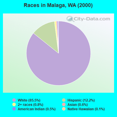
- 2,99785.5%White alone
- 42912.2%Hispanic
- 280.8%Two or more races
- 220.6%Asian alone
- 190.5%American Indian alone
- 50.1%Native Hawaiian and Other
Pacific Islander alone - 30.09%Black alone
- 30.09%Other race alone
Races in Malaga detailed stats: ancestries, foreign born residents, place of birth
 Recent articles from our blog. Our writers, many of them Ph.D. graduates or candidates, create easy-to-read articles on a wide variety of topics.
Current Local Time: PST time zone
Land area: 121.8 square miles.
Population density: 30 people per square mile (very low).

| Malaga CCD: | 1.0% ($1,691) |
| Washington: | 1.2% ($1,915) |
Nearest city with pop. 50,000+: Yakima, WA  (52.2 miles , pop. 71,845).
Nearest city with pop. 200,000+: East Seattle, WA (91.1 miles , pop. 480,100).
Nearest city with pop. 1,000,000+: Los Angeles, CA (921.2 miles , pop. 3,694,820).
Nearest cities:
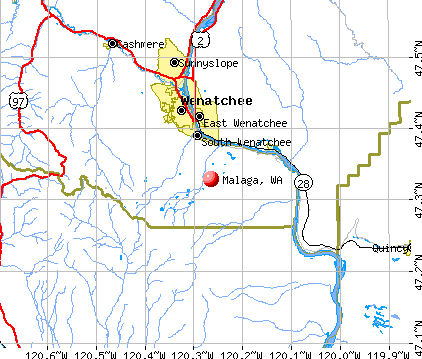
), ), ), Latitude: 47.33 N, Longitude: 120.26 W
Area code commonly used in this area: 509

| Here: | 5.5% |
| Washington: | 4.6% |
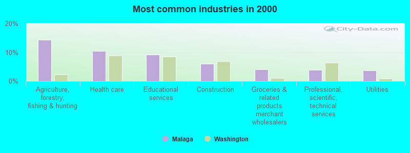
- Agriculture, forestry, fishing & hunting (14.3%)
- Health care (10.4%)
- Educational services (9.3%)
- Construction (6.1%)
- Groceries & related products merchant wholesalers (4.1%)
- Professional, scientific, technical services (3.9%)
- Utilities (3.7%)
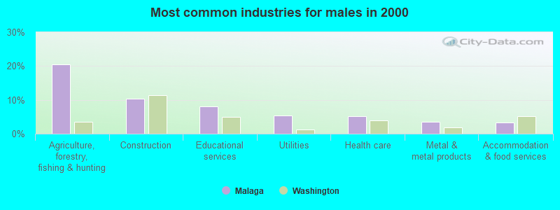
- Agriculture, forestry, fishing & hunting (20.5%)
- Construction (10.4%)
- Educational services (8.1%)
- Utilities (5.3%)
- Health care (5.1%)
- Metal & metal products (3.6%)
- Accommodation & food services (3.4%)
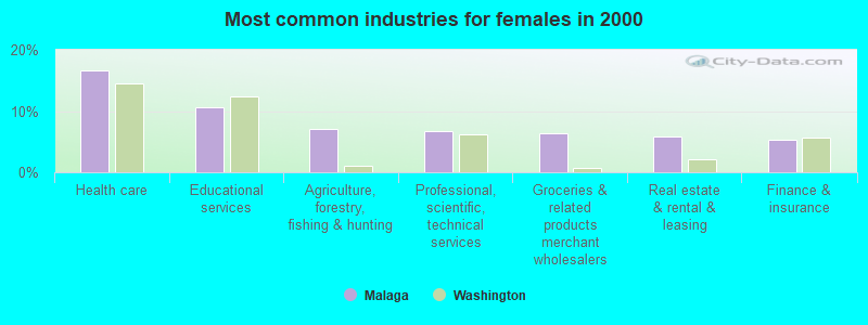
- Health care (16.6%)
- Educational services (10.7%)
- Agriculture, forestry, fishing & hunting (7.0%)
- Professional, scientific, technical services (6.8%)
- Groceries & related products merchant wholesalers (6.3%)
- Real estate & rental & leasing (5.9%)
- Finance & insurance (5.3%)
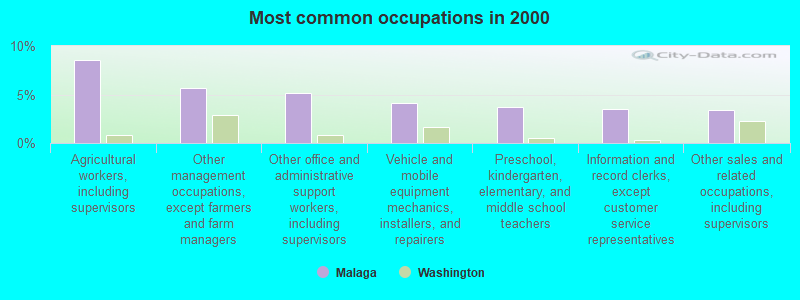
- Agricultural workers, including supervisors (8.5%)
- Other management occupations, except farmers and farm managers (5.7%)
- Other office and administrative support workers, including supervisors (5.1%)
- Vehicle and mobile equipment mechanics, installers, and repairers (4.1%)
- Preschool, kindergarten, elementary, and middle school teachers (3.7%)
- Information and record clerks, except customer service representatives (3.5%)
- Other sales and related occupations, including supervisors (3.4%)
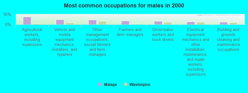
- Agricultural workers, including supervisors (12.3%)
- Vehicle and mobile equipment mechanics, installers, and repairers (7.5%)
- Other management occupations, except farmers and farm managers (7.3%)
- Farmers and farm managers (6.1%)
- Driver/sales workers and truck drivers (5.5%)
- Electrical equipment mechanics and other installation, maintenance, and repair workers, including supervisors (4.4%)
- Building and grounds cleaning and maintenance occupations (4.0%)

- Other office and administrative support workers, including supervisors (10.2%)
- Information and record clerks, except customer service representatives (7.7%)
- Preschool, kindergarten, elementary, and middle school teachers (5.7%)
- Other sales and related occupations, including supervisors (5.3%)
- Secretaries and administrative assistants (4.8%)
- Supervisors and other personal care and service workers, except child care workers (4.0%)
- Agricultural workers, including supervisors (4.0%)
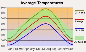
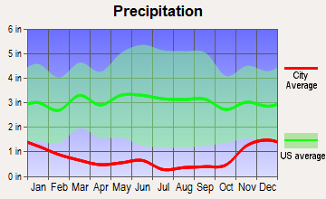
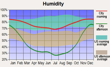
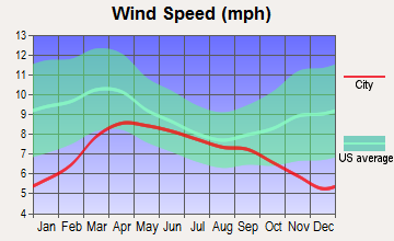
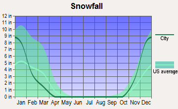
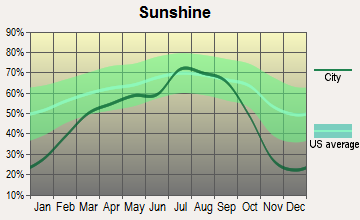
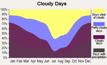
Average climate in Malaga, Washington
Based on data reported by over 4,000 weather stations
(lower is better)
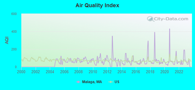
Air Quality Index (AQI) level in 2022 was 76.2. This is about average.
| City: | 76.2 |
| U.S.: | 72.6 |
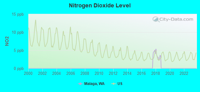
Nitrogen Dioxide (NO2) [ppb] level in 2018 was 3.38. This is significantly better than average. Closest monitor was 20.5 miles away from the city center.
| City: | 3.38 |
| U.S.: | 5.11 |
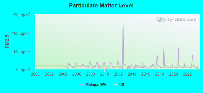
Particulate Matter (PM2.5) [µg/m3] level in 2022 was 9.85. This is worse than average. Closest monitor was 6.3 miles away from the city center.
| City: | 9.85 |
| U.S.: | 8.11 |
Earthquake activity:
Malaga-area historical earthquake activity is significantly above Washington state average. It is 1277% greater than the overall U.S. average.On 4/13/1949 at 19:55:42, a magnitude 7.0 (7.0 UK, Class: Major, Intensity: VIII - XII) earthquake occurred 105.0 miles away from Malaga center, causing $80,000,000 total damage
On 2/28/2001 at 18:54:32, a magnitude 6.8 (6.5 MB, 6.6 MS, 6.8 MW, Class: Strong, Intensity: VII - IX) earthquake occurred 110.0 miles away from the city center, causing $2,000,000,000 total damage and $305,000,000 insured losses
On 2/28/2001 at 18:54:32, a magnitude 6.8 (6.8 MD, Depth: 32.2 mi) earthquake occurred 116.3 miles away from Malaga center
On 4/29/1965 at 15:28:43, a magnitude 6.6 (6.6 UK) earthquake occurred 97.0 miles away from the city center, causing $28,000,000 total damage
On 10/28/1983 at 14:06:06, a magnitude 7.3 (6.2 MB, 7.3 MS, 7.0 MW) earthquake occurred 384.6 miles away from Malaga center, causing 2 deaths (2 shaking deaths) and 3 injuries, causing $15,000,000 total damage
On 8/18/1959 at 06:37:13, a magnitude 7.7 (7.7 UK) earthquake occurred 499.7 miles away from the city center, causing $26,000,000 total damage
Magnitude types: body-wave magnitude (MB), duration magnitude (MD), surface-wave magnitude (MS), moment magnitude (MW)
Natural disasters:
The number of natural disasters in Chelan County (27) is a lot greater than the US average (15).Major Disasters (Presidential) Declared: 13
Emergencies Declared: 4
Causes of natural disasters: Fires: 13, Floods: 8, Storms: 6, Mudslides: 5, Landslides: 4, Winter Storms: 3, Winds: 2, Drought: 1, Earthquake: 1, Hurricane: 1, Volcanic Eruption: 1, Other: 1 (Note: some incidents may be assigned to more than one category).
Hospitals and medical centers near Malaga:
- HIGHLINE CARE CENTERS, L L C (Nursing Home, about 5 miles away; EAST WENATCHEE, WA)
- PARKSIDE HEALTHCARE, L L C (Nursing Home, about 6 miles away; WENATCHEE, WA)
- PARKSIDE MANOR CONV CTR (Nursing Home, about 6 miles away; WENATCHEE, WA)
- CENTRAL WA HOSPITAL TRANSITIONAL CU (Nursing Home, about 6 miles away; WENATCHEE, WA)
- CENTRAL WA HEALTH SERVICES (Home Health Center, about 7 miles away; WENATCHEE, WA)
- CENTRAL WASHINGTON HOSPITAL Acute Care Hospitals (about 7 miles away; WENATCHEE, WA)
- HEALTHY OPTIONS (Home Health Center, about 7 miles away; WENATCHEE, WA)
Colleges/universities with over 2000 students nearest to Malaga:
- Wenatchee Valley College (about 8 miles; Wenatchee, WA; Full-time enrollment: 2,951)
- Central Washington University (about 26 miles; Ellensburg, WA; FT enrollment: 10,960)
- Yakima Valley Community College (about 53 miles; Yakima, WA; FT enrollment: 3,632)
- Green River Community College (about 90 miles; Auburn, WA; FT enrollment: 7,425)
- Bellevue College (about 90 miles; Bellevue, WA; FT enrollment: 10,940)
- Renton Technical College (about 91 miles; Renton, WA; FT enrollment: 2,549)
- Columbia Basin College (about 93 miles; Pasco, WA; FT enrollment: 5,111)
Points of interest:
Notable locations in Malaga: Valhala Substation (A), Colockum Game Range Headquarters (B), Beehive Spring Campground (C), Three Lakes Golf Club (D), Scout-a- Vista (E), Mission Ridge Winter Sports Area (F), Naneum Lookout (G), Chelan County Fire District 1 Station 17 Malaga Complex (H), Chelan County Fire District 1 Station 14 Squilchuck (I), Chelan County Fire District 1 Wenatchee Station 15 (J), Scout-A-Vista Lodge (K). Display/hide their locations on the map
Cemetery: Stemilt Hill Cemetery (1). Display/hide its location on the map
Lakes and reservoirs: Marion Lake (A), Clara Lake (B), Stemilt Project Reservoir (C), Beehive Reservoir (D), H and H Reservoir Number Two (E), Lily Lake (F), Wenatchee Heights Reservoir Number One (G), Wenatchee Heights Reservoir Number Two (H). Display/hide their locations on the map
Creeks: Colockum Creek (A), Lake Creek (B), Middle Creek (C), Miners Run Creek (D), Orr Creek (E), Stemilt Creek (F). Display/hide their locations on the map
Park in Malaga: Squilchuck State Park (1). Display/hide its location on the map
| This place: | 2.7 people |
| Washington: | 2.5 people |
| This place: | 78.2% |
| Whole state: | 64.4% |
| This place: | 5.5% |
| Whole state: | 7.7% |
Likely homosexual households (counted as self-reported same-sex unmarried-partner households)
- Lesbian couples: 0.3% of all households
- Gay men: 0.4% of all households
| This place: | 6.3% |
| Whole state: | 10.6% |
| This place: | 1.3% |
| Whole state: | 4.6% |
For population 15 years and over in Malaga:

- Never married: 20.0%
- Now married: 69.0%
- Separated: 0.6%
- Widowed: 3.5%
- Divorced: 7.6%
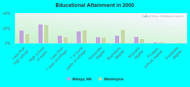
For population 25 years and over in Malaga:
- High school or higher: 82.4%
- Bachelor's degree or higher: 21.5%
- Graduate or professional degree: 10.9%
- Unemployed: 6.8%
- Mean travel time to work (commute): 20.3 minutes
| Here: | 12.9 |
| Washington average: | 11.3 |
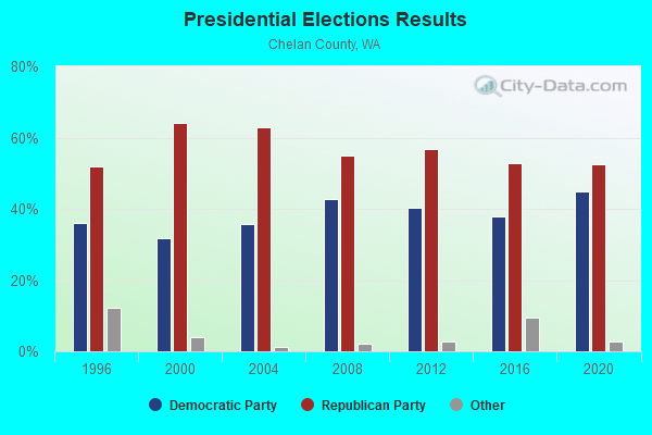
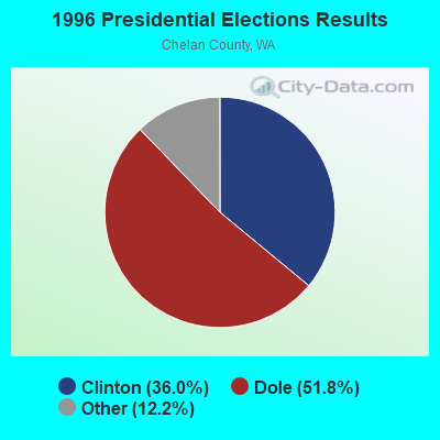
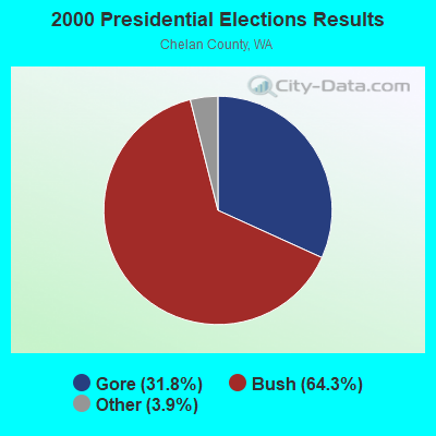
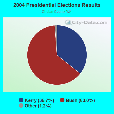

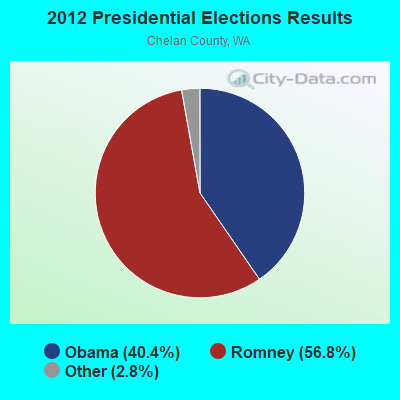
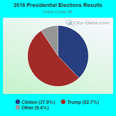
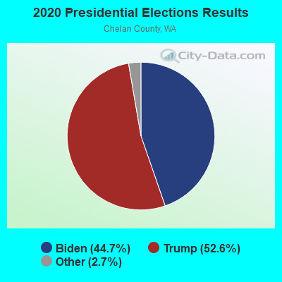
Graphs represent county-level data. Detailed 2008 Election Results
Religion statistics for Malaga, WA (based on Chelan County data)
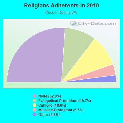
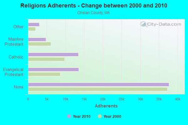
| Religion | Adherents | Congregations |
|---|---|---|
| Evangelical Protestant | 13,576 | 57 |
| Catholic | 13,500 | 3 |
| Mainline Protestant | 4,729 | 24 |
| Other | 2,974 | 12 |
| None | 37,674 | - |
Food Environment Statistics:
| Chelan County: | 2.83 / 10,000 pop. |
| Washington: | 2.06 / 10,000 pop. |
| Chelan County: | 1.13 / 10,000 pop. |
| Washington: | 1.18 / 10,000 pop. |
| This county: | 3.68 / 10,000 pop. |
| Washington: | 2.67 / 10,000 pop. |
| Here: | 12.31 / 10,000 pop. |
| Washington: | 8.26 / 10,000 pop. |
| Here: | 7.6% |
| Washington: | 7.7% |
| This county: | 21.6% |
| Washington: | 25.7% |
| This county: | 20.2% |
| State: | 13.9% |
Strongest AM radio stations in Malaga:
- KPQ (560 AM; 5 kW; WENATCHEE, WA; Owner: WESTCOAST BROADCASTING CO.)
- KTBI (810 AM; daytime; 50 kW; EPHRATA, WA; Owner: TACOMA BROADCASTERS, INCORPORATED)
- KWWX (1340 AM; 1 kW; WENATCHEE, WA; Owner: FISHER RADIO REGIONAL GROUP, INC..)
- KKRT (900 AM; 1 kW; WENATCHEE, WA; Owner: MCC RADIO, LLC)
- KIXI (880 AM; 50 kW; MERCER ISLAND/SEATTL, WA; Owner: BELLEVUE RADIO, INC.)
- KIRO (710 AM; 50 kW; SEATTLE, WA; Owner: ENTERCOM SEATTLE LICENSE, LLC)
- KTTH (770 AM; 50 kW; SEATTLE, WA; Owner: ENTERCOM SEATTLE LICENSE, LLC)
- KGNW (820 AM; 50 kW; BURIEN-SEATTLE, WA; Owner: INSPIRATION MEDIA, INC.)
- KJR (950 AM; 50 kW; SEATTLE, WA)
- KOMO (1000 AM; 50 kW; SEATTLE, WA; Owner: FISHER BROADCASTING - SEATTLE RADIO, L.L.C.)
- KYCW (1090 AM; 50 kW; SEATTLE, WA; Owner: INFINITY RADIO SUBSIDIARY OPERATIONS INC.)
- KRKO (1380 AM; 50 kW; EVERETT, WA; Owner: S-R BROADCASTING, CO.)
- KYAK (930 AM; 10 kW; YAKIMA, WA)
Strongest FM radio stations in Malaga:
- KPLW (89.9 FM; WENATCHEE, WA; Owner: GROWING CHRISTIAN FOUNDATION)
- KNWR (90.7 FM; ELLENSBURG, WA; Owner: WASHINGTON STATE UNIVERSITY)
- KPQ-FM (102.1 FM; WENATCHEE, WA; Owner: WESCOAST BROADCASTING COMPANY)
- KKRV (104.7 FM; WENATCHEE, WA; Owner: MCC RADIO, LLC)
- KOHO-FM (101.1 FM; LEAVENWORTH, WA; Owner: ICICLE BROADCASTING, INC.)
- KWWW-FM (96.7 FM; QUINCY, WA; Owner: FISHER RADIO REGIONAL GROUP, INC..)
- KZML (95.9 FM; QUINCY, WA; Owner: BUTTERFIELD BROADCASTING CORPORATION)
- K257DN (99.3 FM; BREWSTER, WA; Owner: BREWSTER GRANGE #1018)
- KXLE-FM (95.3 FM; ELLENSBURG, WA; Owner: KXLE, INC.)
- KQBE (103.1 FM; ELLENSBURG, WA; Owner: PEAK COMMUNICATIONS, INC.)
- K232CV (94.3 FM; ELLENSBURG, WA; Owner: CITICASTERS LICENSES, L.P.)
- KRCW (96.3 FM; ROYAL CITY, WA; Owner: FARMWORKER EDUCATIONAL RADIO NETWORK, INC.)
- KFFM (107.3 FM; YAKIMA, WA; Owner: CITICASTERS LICENSES, L.P.)
- KOZI-FM (93.5 FM; CHELAN, WA; Owner: ICICLE BROADCASTING, INC.)
- KCSH (88.9 FM; ELLENSBURG, WA; Owner: LIFETALK RADIO, INC.)
- KLWS (91.5 FM; MOSES LAKE, WA; Owner: WASHINGTON STATE UNIVERSITY)
- KULE-FM (92.3 FM; EPHRATA, WA; Owner: BUTTERFIELD BROADCASTING CORPORATION)
- KZTA (96.9 FM; NACHES, WA; Owner: BUTTERFIELD BROADCASTING CORP)
- KZPH (106.7 FM; CASHMERE, WA; Owner: FISHER RADIO REGIONAL GROUP, INC.)
- KYSN (97.7 FM; EAST WENATCHEE, WA; Owner: FISHER RADIO REGIONAL GROUP, INC.)
TV broadcast stations around Malaga:
- KWCC-LP (Channel 47; WENATCHEE, ETC., WA; Owner: APPLE VALLEY TV ASSOCIATION, INC.)
- K51DR (Channel 51; WENATCHEE, WA; Owner: APPLE VALLEY TV ASSOCIATION, INC.)
- K53DN (Channel 53; EAST WENATCHEE, WA; Owner: APPLE VALLEY TV ASSOCIATION, INC.)
- K55FO (Channel 55; EAST WENATCHEE, WA; Owner: APPLE VALLEY TV ASSOCIATION, INC.)
- K09CL (Channel 9; ROCK ISLAND, ETC., WA; Owner: APPLE VALLEY TV ASSOCIATION, INC.)
- K11CS (Channel 11; ROCK ISLAND, ETC., WA; Owner: APPLE VALLEY TV ASSOCIATION, INC.)
- K09FF (Channel 9; SQUILCHUCK STATE PAR, WA; Owner: APPLE VALLEY TV ASSOCIATION, INC.)
- K11FJ (Channel 11; SQUILCHUCK STATE PAR, WA; Owner: APPLE VALLEY TV ASSOCIATION, INC.)
- K13CQ (Channel 13; ROCK ISLAND, ETC., WA; Owner: APPLE VALLEY TV ASSOCIATION, INC.)
- K13EZ (Channel 13; SQUILCHUCK STATE PAR, WA; Owner: APPLE VALLEY TV ASSOCIATION, INC.)
- K34EM (Channel 34; WENATCHEE, WA; Owner: TRINITY BROADCASTING NETWORK)
- KWWA-LP (Channel 49; ELLENSBURG, ETC., WA; Owner: WATCHTV, INC.)
- K24EX (Channel 24; WENATCHEE, WA; Owner: SPOKANE TELEVISION, INC.)
- K18AD (Channel 18; EAST WENATCHEE, ETC., WA; Owner: KCTS TELEVISION)
- K69BF (Channel 69; STEMILT, ETC., WA; Owner: MOUNTAIN LICENSES, L.P.)
FCC Registered Cell Phone Towers:
1- Laurel Hill 3.5 Miles Sw Of Wenatchee (Lat: 47.323417 Lon: -120.233389), Type: Ltower, Structure height: 58.5 m, Overall height: 59.4 m, Call Sign: KNKN211
Assigned Frequencies: 869.040 MHz, 824.040 MHz, 890.010 MHz, 845.010 MHzGrant Date: 10/16/2019, Expiration Date: 10/01/2029, Certifier: Michael P GogginRegistrant: At&t Services, Inc., 208 S Akard St, 20f, Dallas, TX 75202, Phone: (855) 699-7073, Fax: (214) 746-6410, Email:
FCC Registered Antenna Towers:
6- Josh Humphrey, 2.25 Mi South Of Malaga, Type: 42.7, Structure height: 53007 m, Overall height: 36.6 m, Registrant: Rivercom 911, Jhumphrey@rivercom911.Org, 3rd Floor, Wenat-chee, Phone: (509) 662-4667
- Josh Humphrey, 2.25 Mi South Of Malaga (Lat: 47.342139 Lon: -120.184194), Type: 42.7, Structure height: 53007 m, Overall height: 36.6 m, Registrant: Rivercom 911, Jhumphrey@rivercom911.Org, 3rd Floor, Wenat-chee, Phone: (509) 662-4667
- Josh A Humphrey, 2.25 Miles South Of Malaga (Lat: 47.342139 Lon: -120.184194), Type: 42.7, Structure height: 53007 m, Overall height: 36.6 m, Registrant: Rivercom 911, Jhumphrey@rivercom911.Org, , Wenat-chee, Phone: (509) 662-4667
- Josh A Humphrey, 2.25 Miles South Of Malaga (Lat: 47.342139 Lon: -120.184194), Type: 42.7, Structure height: 53007 m, Overall height: 36.6 m, Registrant: Rivercom 911, Jhumphrey@rivercom911.Org, , Wenat-chee, Phone: (509) 662-4667
- Josh Humphrey, 2.25 Miles South Of Malaga (Lat: 47.342139 Lon: -120.184194), Type: 42.7, Structure height: 53007 m, Overall height: 36.6 m, Registrant: Rivercom 911, Jhumphrey@rivercom911.Org, , Wenat-chee, Phone: (509) 662-4667
- Chad Rumsey, 3825 Joe Miller Rd (Lat: 47.358028 Lon: -120.210472), Type: 32.0, Structure height: 53007 m, Overall height: 30.5 m, Registrant: Harmoni Towers, LLC, Chad.Rumsey@harmonitowers.Com, Suite 450, Charl-otte, Phone: (501) 850-0820
FCC Registered Broadcast Land Mobile Towers:
7- Cathedral Rock, 2.25 Miles South Of Malaga (Lat: 47.342139 Lon: -120.184194), Type: Ltower, Structure height: 36.6 m, Overall height: 42.7 m, Call Sign: KBA454, Licensee ID: L01631591,
Assigned Frequencies: 155.760 MHz, 159.127 MHz, Grant Date: 10/12/2022, Expiration Date: 11/09/2032, Registrant: Douglas County Tls
- L1 MOBILES, Lat: 47.323667 Lon: -120.233444, Call Sign: KSL836,
Assigned Frequencies: 161.100 MHz, Grant Date: 06/19/2015, Expiration Date: 08/22/2025, Registrant: Bnsf Railway Co., 4515 Kansas Ave, Kansas City, KS 66106, Phone: (913) 551-4015, Fax: (913) 551-4053, Email:
- Lat: 47.355556 Lon: -120.122778, Call Sign: WQGF307,
Assigned Frequencies: 462.212 MHz, 462.312 MHz, 462.337 MHz, 462.437 MHz, 467.212 MHz, 467.262 MHz, 467.312 MHz, 467.362 MHz, 467.412 MHz, 467.437 MHz, Grant Date: 12/29/2006, Expiration Date: 06/27/2007, Cancellation Date: 09/01/2007, Certifier: Robert E Tyson, Registrant: Radio Licensing Services, Milwaukie, OR 97269-2161, Phone: (503) 794-3787, Fax: (503) 794-3759, Email:
- Lat: 47.355556 Lon: -120.122778, Call Sign: WQGF309,
Assigned Frequencies: 72.1400 MHz, 72.2200 MHz, 72.3200 MHz, Grant Date: 12/29/2006, Expiration Date: 06/27/2007, Cancellation Date: 09/01/2007, Registrant: Radio Licensing Services, Milwaukie, OR 97269, Phone: (503) 794-3787, Fax: (503) 794-3759, Email:
- WENATCHEE WORKS, Lat: 47.355417 Lon: -120.123944, Call Sign: WQGI964,
Assigned Frequencies: 72.2200 MHz, 72.3200 MHz, 462.212 MHz, 462.312 MHz, 462.337 MHz, 462.437 MHz, 467.212 MHz, 467.262 MHz, 467.312 MHz, 467.362 MHz... (+3 more), Grant Date: 02/06/2017, Expiration Date: 02/01/2027, Certifier: Carla Chow, Registrant: Alcoa Corporation, 201 Isabella Street, Pittsburgh, PA 15212, Phone: (412) 553-1949, Email:
- Lat: 47.365167 Lon: -120.176694, Call Sign: WQMC907,
Assigned Frequencies: 151.910 MHz, 159.570 MHz, 159.630 MHz, 159.765 MHz, 160.072 MHz, Grant Date: 06/30/2010, Expiration Date: 06/30/2020, Cancellation Date: 09/05/2020, Certifier: Jesse Lane, Registrant: Radio Licensing Services, 4700 Se International Way, Milwaukie, OR 97222, Phone: (503) 794-3761, Fax: (503) 794-3759, Email:
- AMG ALUMINUM N.A., 4400 Kawecki Road (Lat: 47.370167 Lon: -120.185556), Type: Building, Structure height: 9 m, Call Sign: WREA847,
Assigned Frequencies: 462.750 MHz, Grant Date: 09/07/2019, Expiration Date: 09/07/2029, Certifier: Katie Marcoux, Registrant: Visiplex, Inc., 1287 North Barclay Boulevard, Buffalo Grove, IL 60089, Phone: (847) 229-0250, Fax: (847) 229-0259, Email:
FCC Registered Microwave Towers:
12 (See the full list of FCC Registered Microwave Towers in this town)FCC Registered Amateur Radio Licenses:
14 (See the full list of FCC Registered Amateur Radio Licenses in Malaga)FAA Registered Aircraft:
9 (See the full list of FAA Registered Aircraft in Malaga)2002 - 2018 National Fire Incident Reporting System (NFIRS) incidents
- Fire incident types reported to NFIRS in Malaga, WA
- 17461.1%Outside Fires
- 6924.2%Structure Fires
- 3110.9%Mobile Property/Vehicle Fires
- 113.9%Other
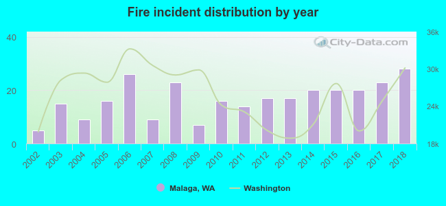 According to the data from the years 2002 - 2018 the average number of fires per year is 17. The highest number of fire incidents - 28 took place in 2018, and the least - 5 in 2002. The data has a growing trend.
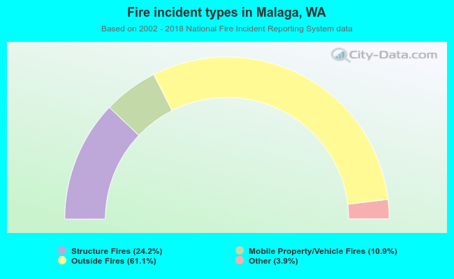 When looking into fire subcategories, the most reports belonged to: Outside Fires (61.1%), and Structure Fires (24.2%).
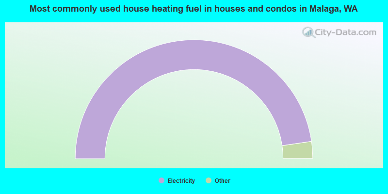
- 95.4%Electricity
- 2.8%Wood
- 1.3%Fuel oil, kerosene, etc.
- 0.5%No fuel used
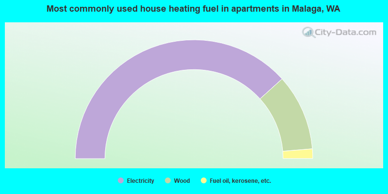
- 76.6%Electricity
- 20.8%Wood
- 2.6%Fuel oil, kerosene, etc.
Malaga compared to Washington state average:
- Unemployed percentage below state average.
- Black race population percentage significantly below state average.
- Foreign-born population percentage significantly below state average.
- Renting percentage below state average.
- Length of stay since moving in significantly above state average.
- Number of rooms per house significantly below state average.
- House age significantly below state average.
Malaga on our top lists:
- #75 on the list of "Top 101 cities with the most residents born in Other Central America (population 500+)"
- #36 on the list of "Top 101 counties with the highest percentage of residents that keep firearms around their homes"
- #80 on the list of "Top 101 counties with the lowest percentage of residents that visited a dentist within the past year"
- #89 on the list of "Top 101 counties with the lowest surface withdrawal of fresh water for public supply (pop. 50,000+)"

|
Total of 4 patent applications in 2008-2024.