Malone-Porter, Washington
Submit your own pictures of this place and show them to the world
- OSM Map
- General Map
- Google Map
- MSN Map
| Males: 248 | |
| Females: 254 |
| Median resident age: | 36.4 years |
| Washington median age: | 35.3 years |
Zip codes: 98541.
| Malone-Porter: | $69,323 |
| WA: | $91,306 |
Estimated per capita income in 2022: $30,057 (it was $15,434 in 2000)
Malone-Porter CDP income, earnings, and wages data
Estimated median house or condo value in 2022: $314,424 (it was $97,800 in 2000)
| Malone-Porter: | $314,424 |
| WA: | $569,500 |
Mean prices in 2022: all housing units: $274,506; detached houses: $297,323; townhouses or other attached units: $218,689; in 2-unit structures: $252,387; in 5-or-more-unit structures: $250,787; mobile homes: $122,211; occupied boats, rvs, vans, etc.: $215,521
Detailed information about poverty and poor residents in Malone-Porter, WA


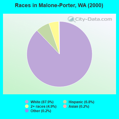
- 41687.9%White alone
- 326.8%Hispanic
- 234.9%Two or more races
- 10.2%Asian alone
- 10.2%Other race alone
Races in Malone-Porter detailed stats: ancestries, foreign born residents, place of birth
 Recent articles from our blog. Our writers, many of them Ph.D. graduates or candidates, create easy-to-read articles on a wide variety of topics.

Ancestries: German (16.1%), Irish (10.8%), English (7.8%), United States (7.4%), Dutch (6.6%), French Canadian (3.8%).
Current Local Time: PST time zone
Land area: 10.5 square miles.
Population density: 48 people per square mile (very low).
| Malone-Porter CDP: | 0.9% ($900) |
| Washington: | 1.2% ($1,915) |
Nearest city with pop. 50,000+: Lakewood, WA  (40.1 miles , pop. 58,211).
Nearest city with pop. 200,000+: Seattle, WA (65.5 miles , pop. 563,374).
Nearest city with pop. 1,000,000+: Los Angeles, CA (927.0 miles , pop. 3,694,820).
Nearest cities:
), ), ), )Latitude: 46.96 N, Longitude: 123.32 W
Area code commonly used in this area: 360

| Here: | 7.4% |
| Washington: | 4.6% |
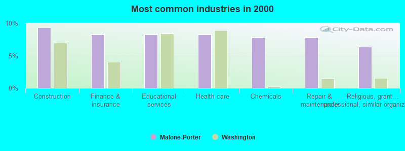
- Construction (9.3%)
- Finance & insurance (8.3%)
- Educational services (8.3%)
- Health care (8.3%)
- Chemicals (7.8%)
- Repair & maintenance (7.8%)
- Religious, grantmaking, civic, professional, similar organizations (6.4%)
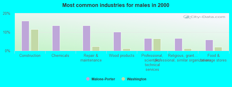
- Construction (16.0%)
- Chemicals (13.4%)
- Repair & maintenance (13.4%)
- Wood products (10.1%)
- Professional, scientific, technical services (6.7%)
- Religious, grantmaking, civic, professional, similar organizations (6.7%)
- Food & beverage stores (5.9%)
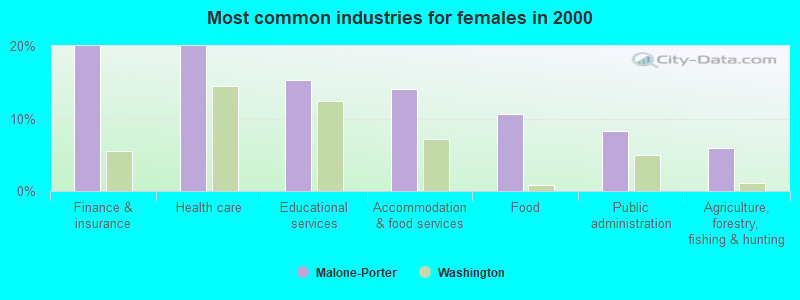
- Finance & insurance (20.0%)
- Health care (20.0%)
- Educational services (15.3%)
- Accommodation & food services (14.1%)
- Food (10.6%)
- Public administration (8.2%)
- Agriculture, forestry, fishing & hunting (5.9%)
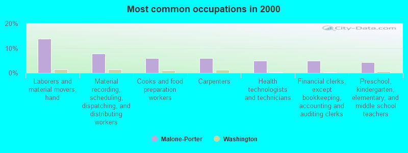
- Laborers and material movers, hand (13.7%)
- Material recording, scheduling, dispatching, and distributing workers (7.8%)
- Cooks and food preparation workers (5.9%)
- Carpenters (5.9%)
- Health technologists and technicians (4.9%)
- Financial clerks, except bookkeeping, accounting and auditing clerks (4.9%)
- Preschool, kindergarten, elementary, and middle school teachers (4.4%)
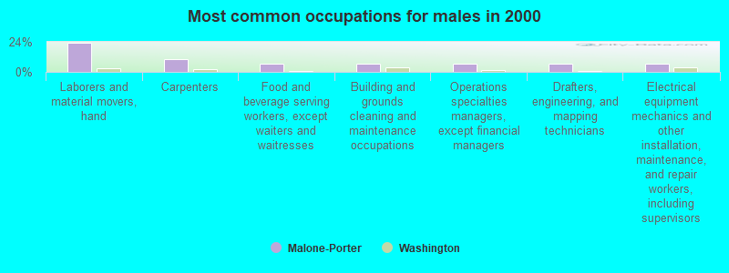
- Laborers and material movers, hand (23.5%)
- Carpenters (10.1%)
- Food and beverage serving workers, except waiters and waitresses (6.7%)
- Building and grounds cleaning and maintenance occupations (6.7%)
- Operations specialties managers, except financial managers (6.7%)
- Drafters, engineering, and mapping technicians (6.7%)
- Electrical equipment mechanics and other installation, maintenance, and repair workers, including supervisors (6.7%)
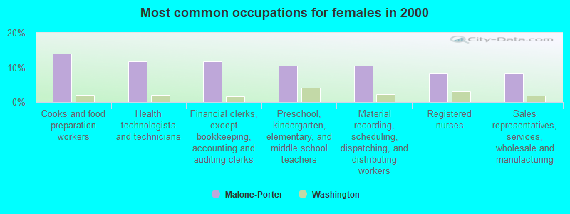
- Cooks and food preparation workers (14.1%)
- Health technologists and technicians (11.8%)
- Financial clerks, except bookkeeping, accounting and auditing clerks (11.8%)
- Preschool, kindergarten, elementary, and middle school teachers (10.6%)
- Material recording, scheduling, dispatching, and distributing workers (10.6%)
- Registered nurses (8.2%)
- Sales representatives, services, wholesale and manufacturing (8.2%)
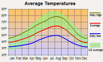
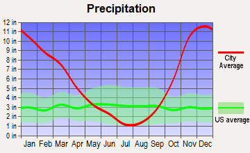
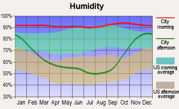
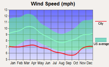
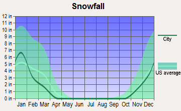
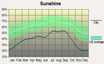
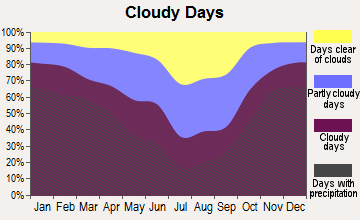
Average climate in Malone-Porter, Washington
Based on data reported by over 4,000 weather stations
(lower is better)
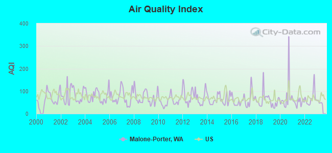
Air Quality Index (AQI) level in 2022 was 69.5. This is about average.
| City: | 69.5 |
| U.S.: | 72.6 |
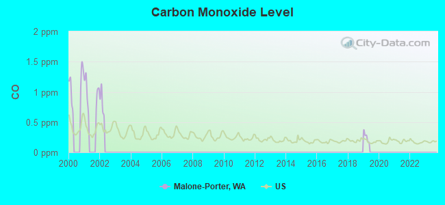
Carbon Monoxide (CO) [ppm] level in 2001 was 0.978. This is significantly worse than average. Closest monitor was 20.5 miles away from the city center.
| City: | 0.978 |
| U.S.: | 0.251 |
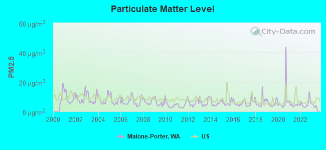
Particulate Matter (PM2.5) [µg/m3] level in 2022 was 5.41. This is significantly better than average. Closest monitor was 21.0 miles away from the city center.
| City: | 5.41 |
| U.S.: | 8.11 |
Earthquake activity:
Malone-Porter-area historical earthquake activity is significantly above Washington state average. It is 1323% greater than the overall U.S. average.On 4/13/1949 at 19:55:42, a magnitude 7.0 (7.0 UK, Class: Major, Intensity: VIII - XII) earthquake occurred 43.6 miles away from Malone-Porter center, causing $80,000,000 total damage
On 2/28/2001 at 18:54:32, a magnitude 6.8 (6.8 MD, Depth: 32.2 mi, Class: Strong, Intensity: VII - IX) earthquake occurred 31.0 miles away from the city center
On 2/28/2001 at 18:54:32, a magnitude 6.8 (6.5 MB, 6.6 MS, 6.8 MW) earthquake occurred 36.1 miles away from the city center, causing $2,000,000,000 total damage and $305,000,000 insured losses
On 4/29/1965 at 15:28:43, a magnitude 6.6 (6.6 UK) earthquake occurred 52.7 miles away from the city center, causing $28,000,000 total damage
On 7/3/1999 at 01:43:54, a magnitude 5.8 (5.4 MB, 5.5 MS, 5.8 MW, 5.3 ME, Depth: 25.2 mi, Class: Moderate, Intensity: VI - VII) earthquake occurred 8.2 miles away from the city center
On 1/31/1922 at 13:17:28, a magnitude 7.6 (7.6 UK) earthquake occurred 446.9 miles away from the city center
Magnitude types: body-wave magnitude (MB), duration magnitude (MD), energy magnitude (ME), surface-wave magnitude (MS), moment magnitude (MW)
Natural disasters:
The number of natural disasters in Grays Harbor County (28) is a lot greater than the US average (15).Major Disasters (Presidential) Declared: 25
Emergencies Declared: 1
Causes of natural disasters: Floods: 21, Storms: 15, Mudslides: 12, Landslides: 10, Winter Storms: 7, Winds: 4, Heavy Rains: 2, Snows: 2, Tornadoes: 2, Earthquake: 1, Hurricane: 1, Volcanic Eruption: 1, Other: 1 (Note: some incidents may be assigned to more than one category).

Hospitals and medical centers near Malone-Porter:
- OAKHURST CONVALESCENT CENTER (Nursing Home, about 5 miles away; ELMA, WA)
- BEECHWOOD NURSING HOME (Nursing Home, about 5 miles away; ELMA, WA)
- MONTESANO HEALTH AND REHAB CENTER (Nursing Home, about 13 miles away; MONTESANO, WA)
- EDGEWOOD MANOR OF GRAYS HARBOR, INC (Nursing Home, about 14 miles away; MONTESANO, WA)
Colleges/universities with over 2000 students nearest to Malone-Porter:
- The Evergreen State College (about 19 miles; Olympia, WA; Full-time enrollment: 4,613)
- South Puget Sound Community College (about 20 miles; Olympia, WA; FT enrollment: 3,981)
- Centralia College (about 24 miles; Centralia, WA; FT enrollment: 2,354)
- Pierce College at Fort Steilacoom (about 39 miles; Lakewood, WA; FT enrollment: 5,228)
- Clover Park Technical College (about 42 miles; Lakewood, WA; FT enrollment: 4,185)
- Tacoma Community College (about 43 miles; Tacoma, WA; FT enrollment: 6,622)
- Pacific Lutheran University (about 44 miles; Tacoma, WA; FT enrollment: 3,548)
Points of interest:
Notable location: Grays Harbor County Fire District 5 Station 52 - Bush Creek (A). Display/hide its location on the map
Church in Malone-Porter: Malone Assembly of God Church (A). Display/hide its location on the map
Creeks: Sand Creek (A), West Fork Porter Creek (B). Display/hide their locations on the map
| This place: | 2.8 people |
| Washington: | 2.5 people |
| This place: | 72.1% |
| Whole state: | 66.5% |
| This place: | 6.4% |
| Whole state: | 6.1% |
No gay or lesbian households reported
| This place: | 8.7% |
| Whole state: | 10.6% |
| This place: | 1.4% |
| Whole state: | 4.6% |
For population 15 years and over in Malone-Porter:
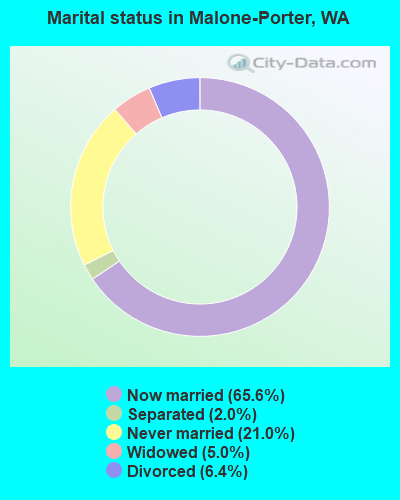
- Never married: 21.0%
- Now married: 65.6%
- Separated: 2.0%
- Widowed: 5.0%
- Divorced: 6.4%
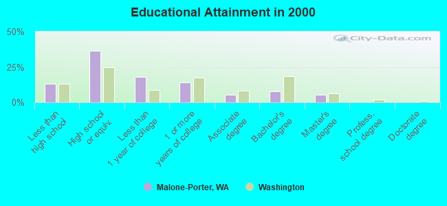
For population 25 years and over in Malone-Porter:
- High school or higher: 86.9%
- Bachelor's degree or higher: 13.1%
- Graduate or professional degree: 5.1%
- Unemployed: 10.5%
- Mean travel time to work (commute): 22.9 minutes
| Here: | 10.7 |
| Washington average: | 11.3 |
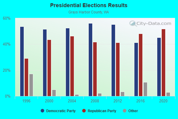
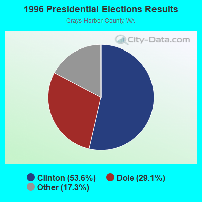
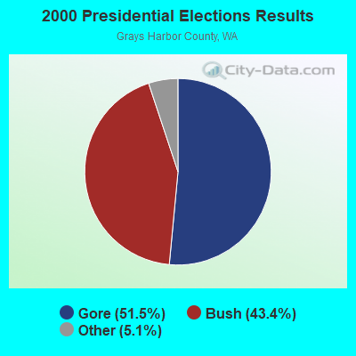
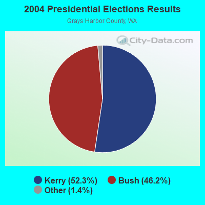
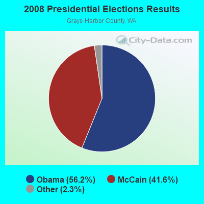

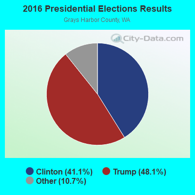
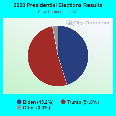
Graphs represent county-level data. Detailed 2008 Election Results
Religion statistics for Malone-Porter, WA (based on Grays Harbor County data)
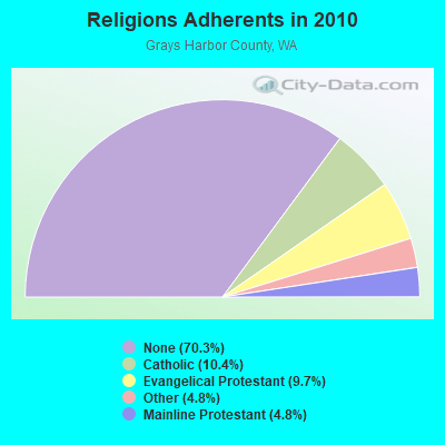
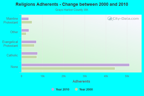
| Religion | Adherents | Congregations |
|---|---|---|
| Catholic | 7,602 | 8 |
| Evangelical Protestant | 7,083 | 58 |
| Other | 3,506 | 14 |
| Mainline Protestant | 3,459 | 25 |
| None | 51,147 | - |
Food Environment Statistics:
| Grays Harbor County: | 3.51 / 10,000 pop. |
| Washington: | 2.06 / 10,000 pop. |
| Grays Harbor County: | 2.95 / 10,000 pop. |
| Washington: | 1.18 / 10,000 pop. |
| Grays Harbor County: | 4.21 / 10,000 pop. |
| Washington: | 2.67 / 10,000 pop. |
| Grays Harbor County: | 8.99 / 10,000 pop. |
| Washington: | 8.26 / 10,000 pop. |
| This county: | 11.0% |
| Washington: | 7.7% |
| Here: | 33.8% |
| State: | 25.7% |
| This county: | 18.4% |
| State: | 13.9% |
Strongest AM radio stations in Malone-Porter:
- KIRO (710 AM; 50 kW; SEATTLE, WA; Owner: ENTERCOM SEATTLE LICENSE, LLC)
- KTTH (770 AM; 50 kW; SEATTLE, WA; Owner: ENTERCOM SEATTLE LICENSE, LLC)
- KJR (950 AM; 50 kW; SEATTLE, WA)
- KGNW (820 AM; 50 kW; BURIEN-SEATTLE, WA; Owner: INSPIRATION MEDIA, INC.)
- KMAS (1030 AM; 10 kW; SHELTON, WA; Owner: SOUND BROADCASTING, INC.)
- KYCW (1090 AM; 50 kW; SEATTLE, WA; Owner: INFINITY RADIO SUBSIDIARY OPERATIONS INC.)
- KOMO (1000 AM; 50 kW; SEATTLE, WA; Owner: FISHER BROADCASTING - SEATTLE RADIO, L.L.C.)
- KIXI (880 AM; 50 kW; MERCER ISLAND/SEATTL, WA; Owner: BELLEVUE RADIO, INC.)
- KGHO (920 AM; 5 kW; OLYMPIA, WA; Owner: SPENCER BROADCASTING, L.P.)
- KKOL (1300 AM; 50 kW; SEATTLE, WA; Owner: INSPIRATION MEDIA, INC.)
- KNWX (1210 AM; 28 kW; AUBURN-FEDERAL WAY, WA; Owner: ENTERCOM SEATTLE LICENSE, LLC)
- KXRO (1320 AM; 5 kW; ABERDEEN, WA; Owner: MCC RADIO, LLC)
- KPOJ (620 AM; 50 kW; PORTLAND, OR; Owner: CITICASTERS LICENSES, L.P.)
Strongest FM radio stations in Malone-Porter:
- KFMY (97.7 FM; RAYMOND, WA; Owner: SOUTH SOUND BROADCASTING, LLC)
- KGY-FM (96.9 FM; MCCLEARY, WA; Owner: KGY, INC.)
- KAYO-FM (99.3 FM; ELMA, WA; Owner: SOUTH SOUND BROADCASTING, LLC)
- KRXY (94.5 FM; SHELTON, WA; Owner: PREMIER BROADCASTERS, INC.)
- KMNT (102.9 FM; CENTRALIA, WA; Owner: CITICASTERS LICENSES, L.P.)
- KSWW (102.1 FM; MONTESANO, WA; Owner: JODESHA BROADCASTING, INC.)
- KXXO (96.1 FM; OLYMPIA, WA; Owner: 3 CITIES, INC.)
- KJET (105.7 FM; SOUTH BEND, WA; Owner: JODESHA BROADCASTING, INC.)
- KRQT (107.1 FM; CASTLE ROCK, WA; Owner: ENTERCOM LONGVIEW LICENSE, LLC)
- K220HE (91.9 FM; CHEHALIS, WA; Owner: CALVARY CHAPEL OF TWIN FALLS, INC.)
- KQBZ (100.7 FM; SEATTLE, WA; Owner: ENTERCOM SEATTLE LICENSE, LLC)
- K216DH (91.1 FM; CATHLAMET, WA; Owner: TILLICUM FOUNDATION)
- KITI-FM (95.1 FM; WINLOCK, WA; Owner: PREMIER BROADCASTERS, INC.)
- K205DD (88.9 FM; BREMERTON, WA; Owner: CALVARY CHAPEL OF TWIN FALLS, INC.)
- KXXK (95.3 FM; HOQUIAM, WA; Owner: MCC RADIO, LLC)
- KDUX-FM (104.7 FM; ABERDEEN, WA; Owner: MCC RADIO, LLC)
- K205EN (88.9 FM; ABERDEEN, WA; Owner: CALVARY CHAPEL OF TWIN FALLS, INC.)
- K207DB (89.3 FM; ABERDEEN, WA; Owner: EDUCATIONAL MEDIA FOUNDATION)
- KACS (90.5 FM; CHEHALIS, WA; Owner: CHEHALIS VALLEY EDUCATIONAL FOUNDATION)
- K254AP (98.7 FM; OLYMPIA, WA; Owner: CALVARY CHAPEL OF TWIN FALLS, INC.)
Malone-Porter fatal accident list:
Jul 29, 2007 08:43 PM, Us-12, Lat: 46.980317, Lon: -123.356464, Vehicles: 2, Persons: 1, Fatalities: 1, Drunk persons involved: 1
- National Bridge Inventory (NBI) Statistics
- 1Number of bridges
- 7ft / 2.5mTotal length
- 224Total average daily traffic
- 31Total average daily truck traffic
- 273Total future (year 2038) average daily traffic
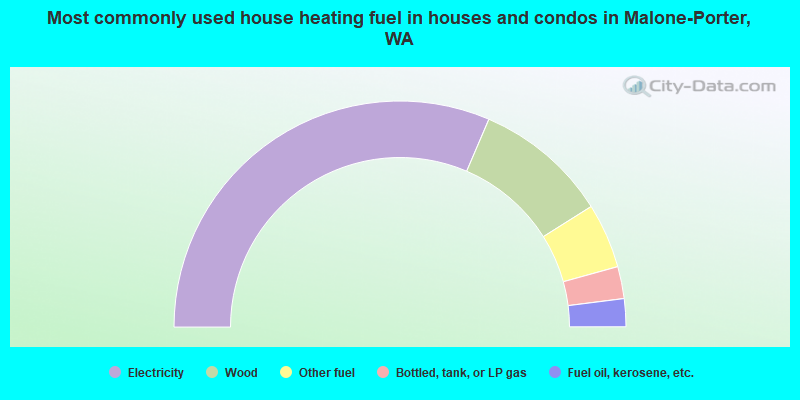
- 62.9%Electricity
- 19.2%Wood
- 9.3%Other fuel
- 4.6%Bottled, tank, or LP gas
- 4.0%Fuel oil, kerosene, etc.
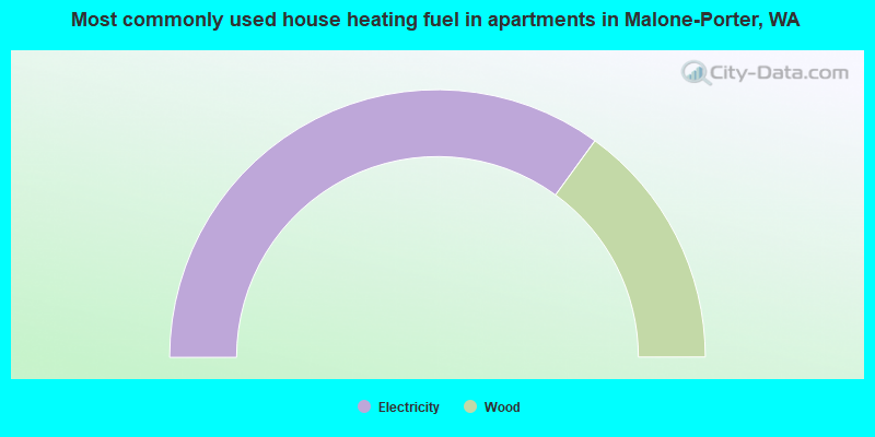
- 70.0%Electricity
- 30.0%Wood
Malone-Porter compared to Washington state average:
- Median house value below state average.
- Black race population percentage significantly below state average.
- Hispanic race population percentage below state average.
- Median age above state average.
- Foreign-born population percentage significantly below state average.
- Renting percentage significantly below state average.
- Length of stay since moving in significantly above state average.
- Number of rooms per house significantly below state average.
- House age significantly below state average.
- Number of college students significantly below state average.
- Percentage of population with a bachelor's degree or higher below state average.