Mamakating, New York
Submit your own pictures of this town and show them to the world
- OSM Map
- Google Map
- MSN Map
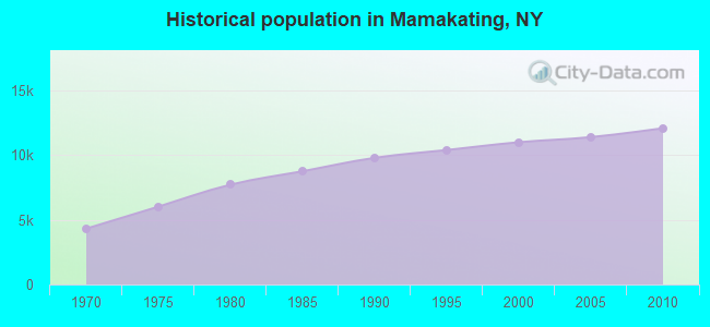
Population change since 2000: +9.8%
 |
| Males: 6,108 | |
| Females: 5,977 |
| Median resident age: | 40.9 years |
| New York median age: | 40.7 years |
Zip codes: 12790.
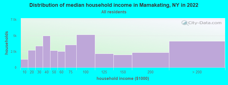
| Mamakating: | $71,927 |
| NY: | $79,557 |
Estimated per capita income in 2022: $44,757 (it was $19,451 in 2000)
Mamakating town income, earnings, and wages data
Estimated median house or condo value in 2022: $282,096 (it was $92,800 in 2000)
| Mamakating: | $282,096 |
| NY: | $400,400 |
Mean prices in 2022: all housing units: $270,318; detached houses: $296,292; townhouses or other attached units: $279,664; in 2-unit structures: $506,859; in 3-to-4-unit structures: $161,643; in 5-or-more-unit structures: $372,499; mobile homes: $81,693
Detailed information about poverty and poor residents in Mamakating, NY
Compare current foreclosures near Mamakating, NY:
| Photo | Address | Area | Beds / Baths | Price | Details |
|---|---|---|---|---|---|

|
#1
Lake Shore Dr E
Rock Hill, NY 12775
|
2,820 sq. feet
|
3 baths 4 beds |
$439,900
|
show details |

|
#2
Alpine Dr
Woodridge, NY 12789
|
1,378 sq. feet
|
2 baths 2 beds |
$275,000
|
show details |

|
#3
Maiden Ln
Maybrook, NY 12543
|
770 sq. feet
|
1 baths 2 beds |
$345,000
|
show details |

|
#4
State St
Middletown, NY 10940
|
1,000 sq. feet
|
1 baths 3 beds |
$365,000
|
show details |

|
#5
Orchard St
Walden, NY 12586
|
1,236 sq. feet
|
1 baths 2 beds |
$89,900
|
show details |

|
#6
Scotchtown Collabar Rd
Middletown, NY 10941
|
2,887 sq. feet
|
3 baths 4 beds |
show details | |

|
#7
Birch St
Bloomingburg, NY 12721
|
2,604 sq. feet
|
2 baths 5 beds |
show details | |

|
#8
Howard Dr
Middletown, NY 10941
|
1,892 sq. feet
|
2 baths 3 beds |
show details | |

|
#9
Clay Hill Rd
Kerhonkson, NY 12446
|
1,244 sq. feet
|
1 baths 2 beds |
show details | |

|
#10
Ferguson Ln
Wurtsboro, NY 12790
|
- sq. feet
|
- baths - beds |
$36,900
|
show details |
| Photo | Address | Area | Beds / Baths | Price | Details |
|---|---|---|---|---|---|

|
#11
Woodlake Dr
Middletown, NY 10940
|
1,460 sq. feet
|
1 baths 2 beds |
show details | |

|
#12
River Rd
Walden, NY 12586
|
2,534 sq. feet
|
3 baths 3 beds |
show details | |

|
#13
Sarine Rd
Wurtsboro, NY 12790
|
1,657 sq. feet
|
2 baths 4 beds |
show details | |

|
#14
Route 209
Kerhonkson, NY 12446
|
1,200 sq. feet
|
1 baths 3 beds |
show details | |

|
#15
St Andrews Ct
Middletown, NY 10941
|
- sq. feet
|
3 baths 4 beds |
show details | |

|
#16
Arden Ct # 2203
Middletown, NY 10940
|
2,028 sq. feet
|
2 baths 3 beds |
show details | |

|
#17
Dolsontown Rd
Middletown, NY 10940
|
- sq. feet
|
1 baths 2 beds |
show details | |

|
#18
Rd B
Cragsmoor, NY 12420
|
960 sq. feet
|
1 baths 3 beds |
show details | |

|
#19
Sagamore Dr
Otisville, NY 10963
|
1,710 sq. feet
|
1 baths 3 beds |
show details | |

|
#20
Alfred Pl
Walden, NY 12586
|
1,544 sq. feet
|
1 baths 3 beds |
show details |
| Photo | Address | Area | Beds / Baths | Price | Details |
|---|---|---|---|---|---|

|
#21
South St
Middletown, NY 10940
|
1,698 sq. feet
|
1 baths 3 beds |
show details | |

|
#22
Beyers Rd
Montgomery, NY 12549
|
3,889 sq. feet
|
4 baths 4 beds |
show details | |

|
#23
Route 209
Cuddebackville, NY 12729
|
1,250 sq. feet
|
1 baths 3 beds |
show details | |

|
#24
Hillside Ln
Ellenville, NY 12428
|
1,640 sq. feet
|
2 baths 3 beds |
show details | |

|
#25
Deer Ct Dr
Middletown, NY 10940
|
1,291 sq. feet
|
2 baths 2 beds |
show details | |

|
#26
Academy Ave
Middletown, NY 10940
|
1,542 sq. feet
|
1 baths 3 beds |
show details | |

|
#27
Marc Ln
Wurtsboro, NY 12790
|
1,008 sq. feet
|
2 baths 3 beds |
show details | |

|
#28
Rakov Rd
Maybrook, NY 12543
|
1,324 sq. feet
|
1 baths 3 beds |
show details | |

|
#29
Watts Ln
Maybrook, NY 12543
|
1,400 sq. feet
|
1 baths 3 beds |
show details | |

|
#30
Railroad Ave # 1
Middletown, NY 10940
|
1,175 sq. feet
|
2 baths 2 beds |
show details |
| Photo | Address | Area | Beds / Baths | Price | Details |
|---|---|---|---|---|---|

|
#31
Prospect Ave
Goshen, NY 10924
|
2,732 sq. feet
|
3 baths 4 beds |
show details | |

|
#32
Edinburgh Rd
Middletown, NY 10941
|
1,038 sq. feet
|
1 baths 3 beds |
show details | |

|
#33
Edinburgh Rd
Middletown, NY 10941
|
1,796 sq. feet
|
2 baths 4 beds |
show details | |

|
#34
Winding Hill Rd
Montgomery, NY 12549
|
3,006 sq. feet
|
1 baths 5 beds |
show details | |

|
#35
Clinton St
Middletown, NY 10940
|
1,902 sq. feet
|
3 baths 3 beds |
show details | |

|
#36
Parkway
Goshen, NY 10924
|
1,728 sq. feet
|
2 baths 3 beds |
show details | |

|
#37
Pleasant Ave
Walden, NY 12586
|
1,040 sq. feet
|
1 baths 3 beds |
show details | |

|
#38
Capron St
Walden, NY 12586
|
1,464 sq. feet
|
2 baths 3 beds |
show details | |

|
#39
Winner Circles Ln
Goshen, NY 10924
|
3,928 sq. feet
|
3 baths 5 beds |
show details | |

|
#40
Lippincott Rd
Wallkill, NY 12589
|
2,262 sq. feet
|
3 baths 3 beds |
show details |
| Photo | Address | Area | Beds / Baths | Price | Details |
|---|---|---|---|---|---|

|
#41
Youngblood Rd
Montgomery, NY 12549
|
2,781 sq. feet
|
2 baths 4 beds |
show details | |

|
#42
Green St
Goshen, NY 10924
|
2,752 sq. feet
|
3 baths 5 beds |
show details | |

|
#43
Amchir Ave
Middletown, NY 10940
|
1,678 sq. feet
|
1 baths 4 beds |
show details | |

|
#44
State Route 42
Sparrow Bush, NY 12780
|
1,368 sq. feet
|
2 baths 3 beds |
show details | |

|
#45
Twin Island Cir
Walden, NY 12586
|
2,188 sq. feet
|
2 baths 3 beds |
show details | |

|
#46
Powers Ln
Montgomery, NY 12549
|
1,798 sq. feet
|
2 baths 3 beds |
show details | |

|
#47
Hidden Ridge Dr
Monticello, NY 12701
|
1,114 sq. feet
|
2 baths 2 beds |
show details | |

|
#48
Greenville Tpke
Middletown, NY 10940
|
1,764 sq. feet
|
2 baths 3 beds |
show details | |

|
#49
Washington Ave
Montgomery, NY 12549
|
2,076 sq. feet
|
2 baths 4 beds |
show details | |

|
Check over 1 million property listings on Foreclosure.com!
|
browse all offers | |||

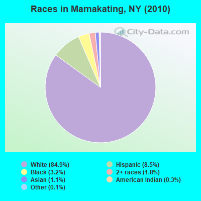
- 10,26184.9%White alone
- 1,0278.5%Hispanic
- 3903.2%Black alone
- 2201.8%Two or more races
- 1351.1%Asian alone
- 360.3%American Indian alone
- 160.1%Other race alone
Races in Mamakating detailed stats: ancestries, foreign born residents, place of birth
 Recent articles from our blog. Our writers, many of them Ph.D. graduates or candidates, create easy-to-read articles on a wide variety of topics.
Ancestries: Irish (22.2%), German (21.4%), Italian (19.8%), English (12.0%), Polish (6.9%), United States (4.4%).
Current Local Time: EST time zone
Land area: 95.9 square miles.
Population density: 126 people per square mile (very low).
593 residents are foreign born (2.8% Europe, 1.8% Latin America, 0.8% Asia).
| This town: | 5.4% |
| New York: | 20.4% |
| Mamakating town: | 2.9% ($2,671) |
| New York: | 1.9% ($2,847) |
Nearest city with pop. 50,000+: Ramapo, NY  (38.3 miles , pop. 108,905).
Nearest city with pop. 200,000+: Bronx, NY (60.2 miles , pop. 1,332,650).
Nearest cities:
), ), ), ), )Latitude: 41.58 N, Longitude: 74.49 W
Area code commonly used in this area: 845
Mamakating, New York accommodation & food services, waste management - Economy and Business Data
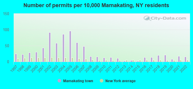
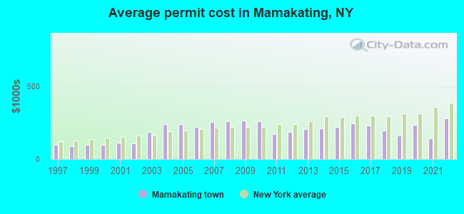
Single-family new house construction building permits:
- 2022: 17 buildings, average cost: $276,800
- 2021: 19 buildings, average cost: $141,900
- 2020: 9 buildings, average cost: $232,100
- 2019: 23 buildings, average cost: $161,400
- 2018: 22 buildings, average cost: $196,500
- 2017: 15 buildings, average cost: $227,900
- 2016: 15 buildings, average cost: $246,000
- 2015: 3 buildings, average cost: $220,500
- 2014: 5 buildings, average cost: $208,000
- 2013: 3 buildings, average cost: $203,300
- 2012: 12 buildings, average cost: $184,000
- 2011: 15 buildings, average cost: $172,800
- 2010: 14 buildings, average cost: $258,000
- 2009: 17 buildings, average cost: $265,300
- 2008: 18 buildings, average cost: $258,600
- 2007: 53 buildings, average cost: $254,100
- 2006: 66 buildings, average cost: $218,500
- 2005: 106 buildings, average cost: $236,600
- 2004: 95 buildings, average cost: $237,200
- 2003: 64 buildings, average cost: $184,400
- 2002: 101 buildings, average cost: $105,100
- 2001: 48 buildings, average cost: $111,500
- 2000: 34 buildings, average cost: $97,300
- 1999: 32 buildings, average cost: $99,400
- 1998: 25 buildings, average cost: $85,600
- 1997: 27 buildings, average cost: $97,300
| Here: | 3.9% |
| New York: | 4.4% |
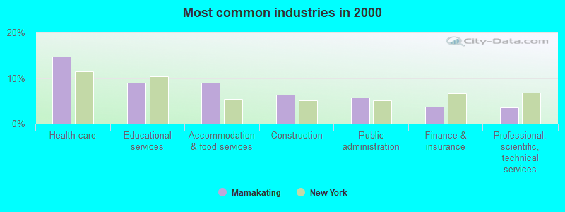
- Health care (14.8%)
- Educational services (9.0%)
- Accommodation & food services (8.9%)
- Construction (6.4%)
- Public administration (5.7%)
- Finance & insurance (3.8%)
- Professional, scientific, technical services (3.6%)
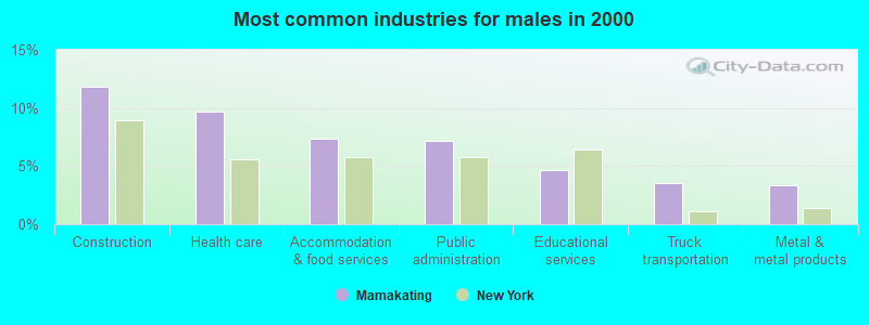
- Construction (11.8%)
- Health care (9.7%)
- Accommodation & food services (7.3%)
- Public administration (7.2%)
- Educational services (4.7%)
- Truck transportation (3.6%)
- Metal & metal products (3.4%)
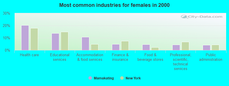
- Health care (20.3%)
- Educational services (13.6%)
- Accommodation & food services (10.7%)
- Finance & insurance (4.8%)
- Food & beverage stores (4.8%)
- Professional, scientific, technical services (4.3%)
- Public administration (4.2%)

- Other production occupations, including supervisors (4.3%)
- Driver/sales workers and truck drivers (4.2%)
- Other office and administrative support workers, including supervisors (3.5%)
- Building and grounds cleaning and maintenance occupations (3.4%)
- Other sales and related occupations, including supervisors (3.4%)
- Registered nurses (3.3%)
- Waiters and waitresses (3.2%)
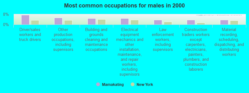
- Driver/sales workers and truck drivers (7.4%)
- Other production occupations, including supervisors (5.4%)
- Building and grounds cleaning and maintenance occupations (4.8%)
- Electrical equipment mechanics and other installation, maintenance, and repair workers, including supervisors (4.7%)
- Law enforcement workers, including supervisors (3.7%)
- Construction traders workers except carpenters, electricians, painters, plumbers, and construction laborers (3.6%)
- Material recording, scheduling, dispatching, and distributing workers (3.6%)
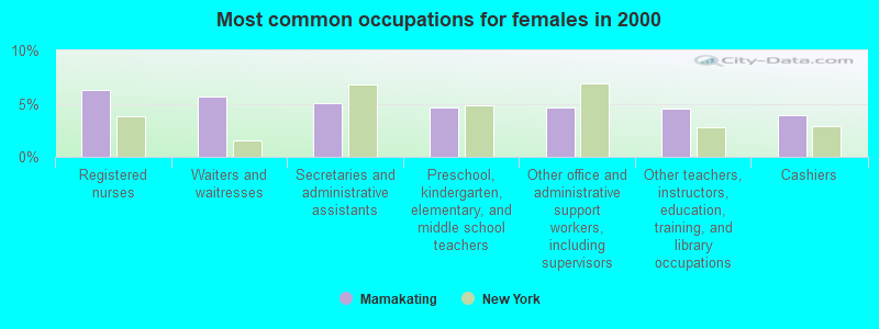
- Registered nurses (6.3%)
- Waiters and waitresses (5.7%)
- Secretaries and administrative assistants (5.1%)
- Preschool, kindergarten, elementary, and middle school teachers (4.7%)
- Other office and administrative support workers, including supervisors (4.6%)
- Other teachers, instructors, education, training, and library occupations (4.5%)
- Cashiers (3.9%)
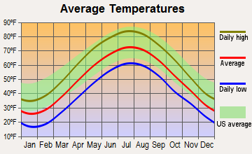
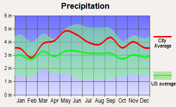
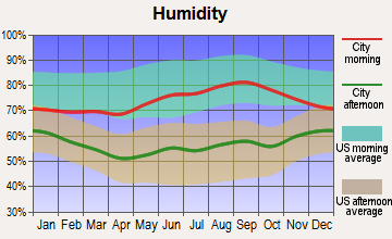
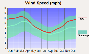
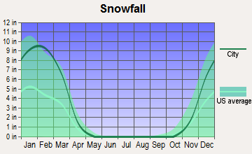
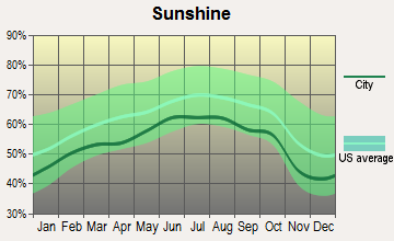
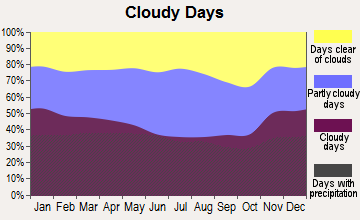
Average climate in Mamakating, New York
Based on data reported by over 4,000 weather stations
(lower is better)
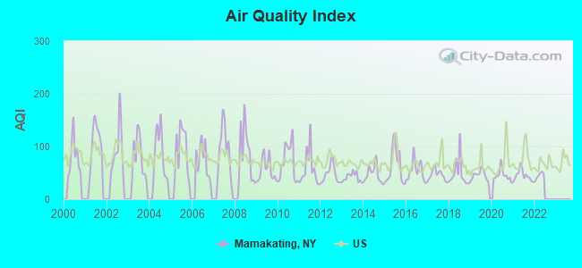
Air Quality Index (AQI) level in 2021 was 44.9. This is significantly better than average.
| City: | 44.9 |
| U.S.: | 72.6 |
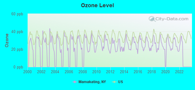
Ozone [ppb] level in 2021 was 24.9. This is better than average. Closest monitor was 14.7 miles away from the city center.
| City: | 24.9 |
| U.S.: | 33.3 |
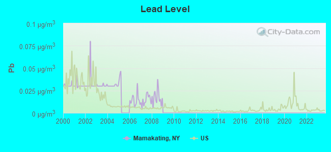
Lead (Pb) [µg/m3] level in 2008 was 0.0173. This is significantly worse than average. Closest monitor was 9.9 miles away from the city center.
| City: | 0.0173 |
| U.S.: | 0.0093 |
Tornado activity:
Mamakating-area historical tornado activity is above New York state average. It is 40% smaller than the overall U.S. average.
On 7/14/1988, a category F3 (max. wind speeds 158-206 mph) tornado 17.6 miles away from the Mamakating town center injured one person and caused between $500,000 and $5,000,000 in damages.
On 5/31/1998, a category F3 tornado 31.5 miles away from the town center injured 2 people and caused $1 million in damages.
Earthquake activity:
Mamakating-area historical earthquake activity is significantly above New York state average. It is 67% smaller than the overall U.S. average.On 10/7/1983 at 10:18:46, a magnitude 5.3 (5.1 MB, 5.3 LG, 5.1 ML, Class: Moderate, Intensity: VI - VII) earthquake occurred 164.0 miles away from Mamakating center
On 4/20/2002 at 10:50:47, a magnitude 5.3 (5.3 ML, Depth: 3.0 mi) earthquake occurred 206.4 miles away from Mamakating center
On 8/23/2011 at 17:51:04, a magnitude 5.8 (5.8 MW, Depth: 3.7 mi) earthquake occurred 313.4 miles away from Mamakating center
On 4/20/2002 at 10:50:47, a magnitude 5.2 (5.2 MB, 4.2 MS, 5.2 MW, 5.0 MW) earthquake occurred 204.5 miles away from Mamakating center
On 1/16/1994 at 01:49:16, a magnitude 4.6 (4.6 MB, 4.6 LG, Depth: 3.1 mi, Class: Light, Intensity: IV - V) earthquake occurred 118.6 miles away from Mamakating center
On 6/17/1991 at 08:53:16, a magnitude 4.1 (4.0 MB, 4.0 LG, Depth: 3.1 mi) earthquake occurred 73.0 miles away from Mamakating center
Magnitude types: regional Lg-wave magnitude (LG), body-wave magnitude (MB), local magnitude (ML), surface-wave magnitude (MS), moment magnitude (MW)
Natural disasters:
The number of natural disasters in Sullivan County (29) is a lot greater than the US average (15).Major Disasters (Presidential) Declared: 19
Emergencies Declared: 9
Causes of natural disasters: Floods: 11, Storms: 11, Hurricanes: 5, Snowstorms: 3, Blizzards: 2, Heavy Rain: 1, Power Outage: 1, Tornado: 1, Tropical Depression: 1, Tropical Storm: 1, Water Shortage: 1, Winter Storm: 1, Other: 3 (Note: some incidents may be assigned to more than one category).
Hospitals and medical centers near Mamakating:
- MIDDLETOWN PSYCHIATRIC CENTER (Hospital, about 10 miles away; MIDDLETOWN, NY)
- ST TERESA'S NURSING AND REHABILITATION CENTER (Nursing Home, about 10 miles away; MIDDLETOWN, NY)
- HORTON MEMORIAL HOSPITAL (Hospital, about 11 miles away; MIDDLETOWN, NY)
- PARK MANOR REHAB AND HEALTH CARE (Nursing Home, about 11 miles away; MIDDLETOWN, NY)
- HOSPICE OF SULLIVAN COUNTY INC (Hospital, about 12 miles away; MONTICELLO, NY)
- FMS-MIDDLETOWN DIALYSIS CENTER (Dialysis Facility, about 12 miles away; MIDDLETOWN, NY)
- ORANGE REGIONAL MEDICAL CENTER Acute Care Hospitals (about 12 miles away; MIDDLETOWN, NY)
Colleges/universities with over 2000 students nearest to Mamakating:
- Orange County Community College (about 11 miles; Middletown, NY; Full-time enrollment: 4,742)
- State University of New York at New Paltz (about 24 miles; New Paltz, NY; FT enrollment: 7,319)
- Mount Saint Mary College (about 26 miles; Newburgh, NY; FT enrollment: 2,166)
- Ulster County Community College (about 27 miles; Stone Ridge, NY; FT enrollment: 2,207)
- Marist College (about 31 miles; Poughkeepsie, NY; FT enrollment: 5,536)
- United States Military Academy (about 31 miles; West Point, NY; FT enrollment: 5,651)
- Culinary Institute of America (about 31 miles; Hyde Park, NY; FT enrollment: 3,869)
User-submitted facts and corrections:
- Town of Mamakating is made up of two villages: Wurtsboro & Bloomingburg. The Shawangunk Ridge divides the Town into two basic areas. West of the Ridge, in the Wurtsbor area are the hamlets of Wesbrookville, Yankee Lake, Mountain Camps, Wurtsboro Hills, Summitville, Phillipsport & a part of Sprin Glen. On the eastern side of the Ridge are Winterton, High View, Bloomingburg, & Burlingham. Interestingly, the Town Board and planning and zoning boards are stacked with members who live on the Eastern side of the Ridge, yet all the industrial development is slated for the Western side. There are big plans for a beautiful gated, golf community on the Bloomingburg side where almost all the town officials reside! On the Wurtsboro side, a distribution center has already been built, a mushroom factory (83 ft. high and 825,000 sq. ft. is being pushed through the review process, and a sand and gravel operation on the Bloomingburg side has plans to move its operation to the now "industrialized" side of the mountain.
Points of interest:
Notable locations in Mamakating: American Legion Camp (A), Bloomingburg Village Wastewater Treatment Plant (B), Roosa Gap (C), Catskill Mountain Ranch Campground (D), Bloomingburg Fire Company (E), Wurtsboro Fire Department (F). Display/hide their locations on the map
Churches in Mamakating include: Saint Josephs Church (A), Community Church of Wurtsboro (B), Mountainview United Methodist Church (C), Our Lady of the Assumption Church (D). Display/hide their locations on the map
Cemeteries: Belle Terre Cemetery (1), Stanton Memorial Cemetery (2), New Vernon Cemetery (3), Sylvan Cemetery (4), Poplar Grove Cemetery (5). Display/hide their locations on the map
Lakes: Lake Jerry (A), Mastens Lake (B), Yankee Lake (C), Lake Altamont (D), Beaverman Lake (E), Echo Lake (F), Fiero Pond (G). Display/hide their locations on the map
Streams, rivers, and creeks: Gumaer Brook (A), Willsey Brook (B), Stony Brook (C), Fall Brook (D), South Brook (E), Primrose Brook (F). Display/hide their locations on the map
| This town: | 2.5 people |
| New York: | 2.6 people |
| This town: | 68.0% |
| Whole state: | 63.5% |
| This town: | 9.7% |
| Whole state: | 6.8% |
Likely homosexual households (counted as self-reported same-sex unmarried-partner households)
- Lesbian couples: 0.5% of all households
- Gay men: 0.4% of all households
| This town: | 10.3% |
| Whole state: | 14.6% |
| This town: | 3.0% |
| Whole state: | 7.4% |
People in group quarters in Mamakating in 2010:
- 24 people in other noninstitutional facilities
- 17 people in group homes intended for adults
- 15 people in nursing facilities/skilled-nursing facilities
For population 15 years and over in Mamakating:
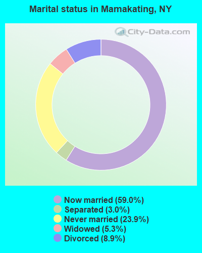
- Never married: 23.9%
- Now married: 59.0%
- Separated: 3.0%
- Widowed: 5.3%
- Divorced: 8.9%
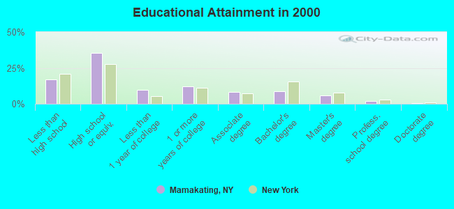
For population 25 years and over in Mamakating:
- High school or higher: 82.9%
- Bachelor's degree or higher: 17.0%
- Graduate or professional degree: 8.2%
- Unemployed: 7.2%
- Mean travel time to work (commute): 35.7 minutes
| Here: | 10.5 |
| New York average: | 14.2 |
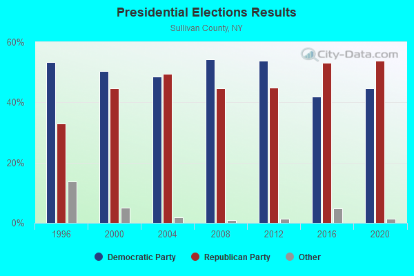
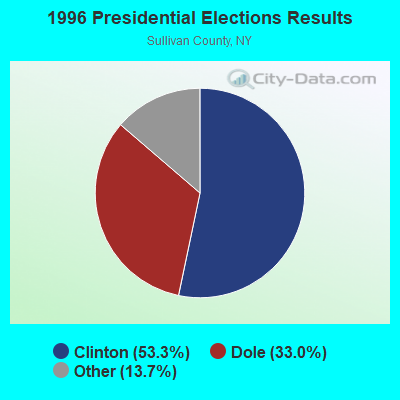
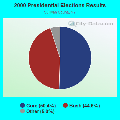
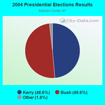

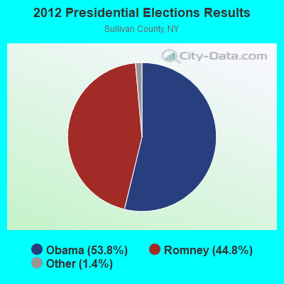
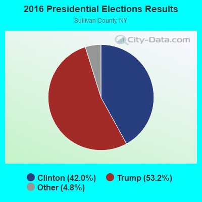
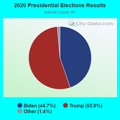
Graphs represent county-level data. Detailed 2008 Election Results
Religion statistics for Mamakating, NY (based on Sullivan County data)
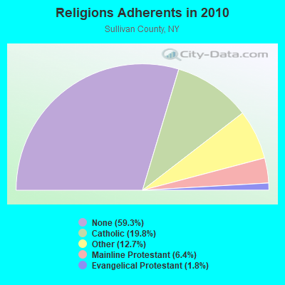
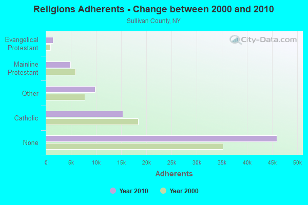
| Religion | Adherents | Congregations |
|---|---|---|
| Catholic | 15,352 | 21 |
| Other | 9,817 | 31 |
| Mainline Protestant | 4,947 | 44 |
| Evangelical Protestant | 1,399 | 18 |
| Orthodox | 60 | 2 |
| None | 45,972 | - |
Food Environment Statistics:
| Sullivan County: | 4.06 / 10,000 pop. |
| New York: | 4.13 / 10,000 pop. |
| Sullivan County: | 0.13 / 10,000 pop. |
| New York: | 0.06 / 10,000 pop. |
| This county: | 2.22 / 10,000 pop. |
| New York: | 0.92 / 10,000 pop. |
| Sullivan County: | 5.63 / 10,000 pop. |
| New York: | 1.68 / 10,000 pop. |
| Here: | 10.99 / 10,000 pop. |
| New York: | 8.82 / 10,000 pop. |
| Here: | 9.4% |
| State: | 8.2% |
| This county: | 24.1% |
| New York: | 23.8% |
| Here: | 16.4% |
| New York: | 15.6% |
Strongest AM radio stations in Mamakating:
- WELV (1370 AM; daytime; 5 kW; ELLENVILLE, NY; Owner: CLEAR CHANNEL BROADCASTING LICENSES, INC.)
- WABC (770 AM; 50 kW; NEW YORK, NY; Owner: WABC-AM RADIO, INC.)
- WMCA (570 AM; 50 kW; NEW YORK, NY; Owner: SALEM MEDIA OF NEW YORK, LLC)
- WGNY (1220 AM; 10 kW; NEWBURGH, NY; Owner: SUNRISE BROADCASTING LLC)
- WOR (710 AM; 50 kW; NEW YORK, NY; Owner: BUCKLEY BROADCASTING CORPORATION)
- WFAN (660 AM; 50 kW; NEW YORK, NY; Owner: INFINITY BROADCASTING OPERATIONS, INC.)
- WSNR (620 AM; 20 kW; JERSEY CITY, NJ)
- WINS (1010 AM; 50 kW; NEW YORK, NY; Owner: INFINITY BROADCASTING OPERATIONS, INC.)
- WCBS (880 AM; 50 kW; NEW YORK, NY; Owner: INFINITY BROADCASTING OPERATIONS, INC.)
- WEPN (1050 AM; 50 kW; NEW YORK, NY; Owner: NEW YORK AM RADIO, LLC)
- WBBR (1130 AM; 50 kW; NEW YORK, NY; Owner: BLOOMBERG COMMUNICATIONS INC.)
- WADO (1280 AM; 50 kW; NEW YORK, NY; Owner: WADO-AM LICENSE CORP.)
- WVNJ (1160 AM; 20 kW; OAKLAND, NJ; Owner: UNIVERSAL B/CASTING OF NEW YORK,INC.)
Strongest FM radio stations in Mamakating:
- WZAD (97.3 FM; WURTSBORO, NY; Owner: CUMULUS LICENSING CORP.)
- WOSR (91.7 FM; MIDDLETOWN, NY; Owner: WAMC)
- WFKP (99.3 FM; ELLENVILLE, NY; Owner: CLEAR CHANNEL BROADCASTING LICENSES, INC.)
- WXHD (90.1 FM; MOUNT HOPE, NY; Owner: AURICLE COMMUNICATIONS)
- WRPJ (88.9 FM; PORT JERVIS, NY; Owner: SOUND OF LIFE, INC.)
- WSUL (98.3 FM; MONTICELLO, NY; Owner: REYNOLDS COMMUNICATIONS, INC.)
- WPDH (101.5 FM; POUGHKEEPSIE, NY; Owner: CUMULUS LICENSING CORP.)
- WRRV (92.7 FM; MIDDLETOWN, NY; Owner: CUMULUS LICENSING CORP.)
- WFNP (88.7 FM; ROSENDALE, NY; Owner: STATE UNIVERSITY OF NEW YORK)
- WRHV (88.7 FM; POUGHKEEPSIE, NY; Owner: WMHT EDUCATIONAL TELECOMMUNICATIONS)
- WLJP (89.3 FM; MONROE, NY; Owner: SOUND OF LIFE, INC.)
- WSPK (104.7 FM; POUGHKEEPSIE, NY; Owner: 6 JOHNSON ROAD LICENSES, INC.)
- WCZX (97.7 FM; HYDE PARK, NY; Owner: CUMULUS LICENSING CORP.)
- WBWZ (93.3 FM; NEW PALTZ, NY; Owner: CLEVELAND RADIO LICENSES, LLC)
- WRWD-FM (107.3 FM; HIGHLAND, NY; Owner: CLEVELAND RADIO LICENSES, LLC)
- WRRB (96.9 FM; ARLINGTON, NY; Owner: CUMULUS LICENSING CORP.)
- WTSX (96.7 FM; PORT JERVIS, NY; Owner: PORT JERVIS BROADCASTING CO., INC.)
- WAMK (90.9 FM; KINGSTON, NY; Owner: W A M C)
- WFGB (89.7 FM; KINGSTON, NY; Owner: SOUND OF LIFE, INC.)
- WPDA (106.1 FM; JEFFERSONVILLE, NY; Owner: CUMULUS LICENSING CORP.)
TV broadcast stations around Mamakating:
- WTBY (Channel 54; POUGHKEEPSIE, NY; Owner: TRINITY BROADCASTING OF NEW YORK, INC.)
- WFME-TV (Channel 66; WEST MILFORD, NJ; Owner: FAMILY STATIONS, INC.)
- W30AZ (Channel 30; LIBERTY, NY; Owner: JOHN MESTER INCOME FAMILY TRUST)
- W27AL (Channel 27; MONTICELLO, NY; Owner: JOHN MESTER INCOME FAMILY TRUST)
- National Bridge Inventory (NBI) Statistics
- 36Number of bridges
- 223ft / 68.3mTotal length
- $44,010,000Total costs
- 225,238Total average daily traffic
- 18,911Total average daily truck traffic
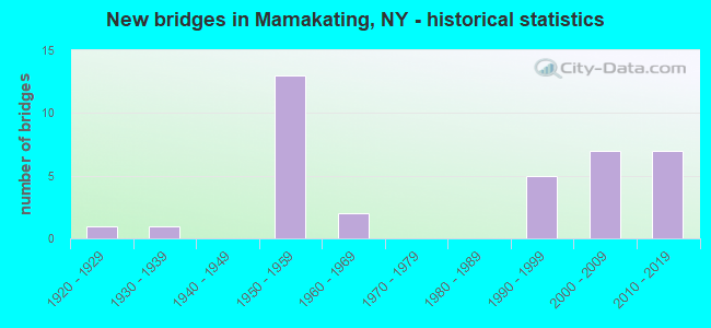
- New bridges - historical statistics
- 11920-1929
- 11930-1939
- 131950-1959
- 21960-1969
- 51990-1999
- 72000-2009
- 72010-2019
FCC Registered Cell Phone Towers:
1 (See the full list of FCC Registered Cell Phone Towers in Mamakating)FCC Registered Antenna Towers:
18 (See the full list of FCC Registered Antenna Towers)FCC Registered Broadcast Land Mobile Towers:
5- Sullivan Cell 24, 18 Ministers Flats Rd. (Lat: 41.635833 Lon: -74.452500), Type: Tower, Structure height: 18.3 m, Call Sign: WQHC956,
Assigned Frequencies: 857.512 MHz, 858.137 MHz, 859.162 MHz, 854.962 MHz, 855.237 MHz, 855.462 MHz, 855.712 MHz, 855.737 MHz, 856.212 MHz, 856.262 MHz... (+19 more), Grant Date: 06/29/2007, Expiration Date: 06/29/2017, Cancellation Date: 01/14/2011, Certifier: Thomas J Cowper, Registrant: Nys Dhses Office Of Interoperable And Emergency Communications, State Office Campus Building 22, 1220 Washington Ave, Albany, NY 12226, Phone: (518) 322-4912, Fax: (518) 322-4975, Email:
- KG100350, 658 Fire Tower Rd. (Lat: 41.613611 Lon: -74.424167), Type: Tower, Structure height: 59 m, Call Sign: WQHN520,
Assigned Frequencies: 855.237 MHz, 857.212 MHz, 858.212 MHz, Grant Date: 09/18/2007, Expiration Date: 09/18/2017, Cancellation Date: 01/14/2011, Certifier: Thomas J Cowper, Registrant: Nys Dhses Office Of Interoperable And Emergency Communications, State Office Campus Building 22, 1220 Washington Ave, Albany, NY 12226, Phone: (518) 322-4912, Fax: (518) 322-4975, Email:
- CSSUL-16, Budd Road (Lat: 41.656667 Lon: -74.490833), Type: Upole, Structure height: 18.3 m, Call Sign: WQHP404,
Assigned Frequencies: 854.962 MHz, 855.237 MHz, 855.712 MHz, 857.212 MHz, 858.212 MHz, Grant Date: 09/25/2007, Expiration Date: 09/25/2017, Cancellation Date: 01/14/2011, Certifier: Thomas J Cowper, Registrant: Nys Dhses Office Of Interoperable And Emergency Communications, State Office Campus Building 22, 1220 Washington Ave, Albany, NY 12226, Phone: (518) 322-4912, Fax: (518) 322-4975, Email:
- CSSUL-33, 95 Davids Rhodes Rd (Lat: 41.518333 Lon: -74.585833), Type: Upole, Structure height: 18.3 m, Call Sign: WQHP412,
Assigned Frequencies: 855.212 MHz, 855.237 MHz, 855.462 MHz, 855.712 MHz, 855.737 MHz, 856.212 MHz, 856.437 MHz, 856.737 MHz, 856.937 MHz, 856.987 MHz... (+13 more), Grant Date: 09/25/2007, Expiration Date: 09/25/2017, Cancellation Date: 01/14/2011, Certifier: Thomas J Cowper, Registrant: Nys Dhses Office Of Interoperable And Emergency Communications, State Office Campus Building 22, 1220 Washington Ave, Albany, NY 12226, Phone: (518) 322-4912, Fax: (518) 322-4975, Email:
- CSSUL-34, Pinekill Rd. (Lat: 41.551667 Lon: -74.564167), Type: Upole, Structure height: 18.3 m, Call Sign: WQHP413,
Assigned Frequencies: 855.212 MHz, 855.237 MHz, 855.712 MHz, 855.737 MHz, 857.212 MHz, Grant Date: 09/25/2007, Expiration Date: 09/25/2017, Cancellation Date: 01/14/2011, Certifier: Thomas J Cowper, Registrant: Nys Dhses Office Of Interoperable And Emergency Communications, State Office Campus Building 22, 1220 Washington Ave, Albany, NY 12226, Phone: (518) 322-4912, Fax: (518) 322-4975, Email:
FCC Registered Microwave Towers:
1- STATION, Fire Tower Rd @ Ne End (Lat: 41.618139 Lon: -74.426806), Structure height: 13.7 m, Call Sign: WNTI362,
Assigned Frequencies: 955.550 MHz, Grant Date: 03/05/2022, Expiration Date: 05/19/2032, Registrant: County Of Sullivan Division Of Public Works, 100 North Street Government Center, Monticello, NY 12701, Phone: (845) 807-0308, Fax: (845) 807-0335, Email:
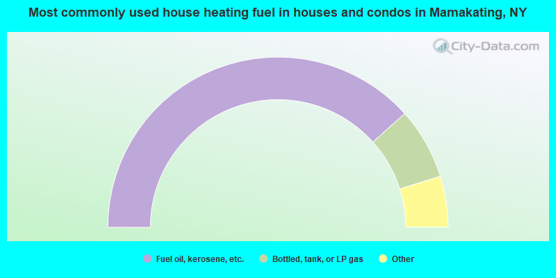
- 76.8%Fuel oil, kerosene, etc.
- 13.6%Bottled, tank, or LP gas
- 3.7%Wood
- 3.4%Electricity
- 1.4%Other fuel
- 0.5%Coal or coke
- 0.4%Utility gas
- 0.2%No fuel used
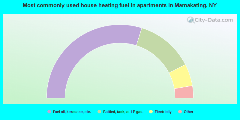
- 59.6%Fuel oil, kerosene, etc.
- 25.3%Bottled, tank, or LP gas
- 9.7%Electricity
- 2.6%Utility gas
- 1.9%Wood
- 0.9%Other fuel
Mamakating compared to New York state average:
- Unemployed percentage below state average.
- Black race population percentage significantly below state average.
- Hispanic race population percentage below state average.
- Foreign-born population percentage significantly below state average.
- Renting percentage below state average.
- Length of stay since moving in significantly above state average.
- Number of rooms per house significantly below state average.
- House age significantly below state average.
- Number of college students below state average.
- Percentage of population with a bachelor's degree or higher below state average.
Mamakating on our top lists:
- #27 on the list of "Top 101 cities with largest percentage of males in industries: health care (population 5,000+)"
- #28 on the list of "Top 101 cities with largest percentage of males in occupations: motor vehicle operators except bus and truck drivers (population 5,000+)"
- #28 on the list of "Top 101 cities with largest percentage of females in occupations: waiters and waitresses (population 5,000+)"
- #29 on the list of "Top 101 cities with largest percentage of males in industries: groceries and related products merchant wholesalers (population 5,000+)"
- #33 on the list of "Top 101 cities with largest percentage of males in occupations: supervisors and other personal care and service workers except personal appearance, transportation, and child care workers (population 5,000+)"
- #35 on the list of "Top 101 cities with largest percentage of females in occupations: other healthcare support occupations (population 5,000+)"
- #35 on the list of "Top 101 cities with largest percentage of males in industries: warehousing and storage (population 5,000+)"
- #37 on the list of "Top 101 cities with largest percentage of females in occupations: plant and system operators (population 5,000+)"
- #42 on the list of "Top 101 cities with largest percentage of males in occupations: architects, surveyors, and cartographers (population 5,000+)"
- #64 on the list of "Top 101 cities with largest percentage of females in industries: nonmetallic mineral products (population 5,000+)"
- #91 on the list of "Top 101 cities with largest percentage of males in industries: publishing, and motion picture and sound recording industries (population 5,000+)"
- #92 on the list of "Top 101 cities with largest percentage of females in industries: publishing, and motion picture and sound recording industries (population 5,000+)"
- #93 on the list of "Top 101 cities with largest percentage of males in industries: paper (population 5,000+)"
- #94 on the list of "Top 101 cities with largest percentage of males in industries: professional and commercial equipment and supplies merchant wholesalers (population 5,000+)"
- #100 on the list of "Top 101 cities with largest percentage of females in industries: music stores (population 5,000+)"
- #95 (12790) on the list of "Top 101 zip codes with the largest percentage of Hungarian first ancestries (pop 5,000+)"
- #43 on the list of "Top 101 counties with the highest surface withdrawal of fresh water for public supply"
- #47 on the list of "Top 101 counties with the smallest number of children under 18 without health insurance coverage in 2000 (pop. 50,000+)"
- #61 on the list of "Top 101 counties with the highest total withdrawal of fresh water for public supply"
- #72 on the list of "Top 101 counties with the largest number of people moving out compared to moving in (pop. 50,000+)"
- #101 on the list of "Top 101 counties with the smallest number of people without health insurance coverage in 2000 (pop. 50,000+)"