Manastash, Washington
Submit your own pictures of this place and show them to the world
- OSM Map
- General Map
- Google Map
- MSN Map

| Males: 2,526 | |
| Females: 2,435 |
| Median resident age: | 42.5 years |
| Washington median age: | 35.3 years |
Zip code: 98946
| Manastash: | $102,172 |
| WA: | $91,306 |
Estimated per capita income in 2022: $49,709 (it was $22,903 in 2000)
Manastash CCD income, earnings, and wages data
Estimated median house or condo value in 2022: $666,833 (it was $178,000 in 2000)
| Manastash: | $666,833 |
| WA: | $569,500 |
Mean prices in 2022: all housing units: $558,806; detached houses: $590,389; townhouses or other attached units: $529,089; in 2-unit structures: $932,679; in 5-or-more-unit structures: $198,030; mobile homes: $270,515; occupied boats, rvs, vans, etc.: $155,306
Detailed information about poverty and poor residents in Manastash, WA


- 4,08294.2%White alone
- 1303.0%Hispanic
- 400.9%Two or more races
- 360.8%American Indian alone
- 210.5%Asian alone
- 130.3%Other race alone
- 50.1%Black alone
- 50.1%Native Hawaiian and Other
Pacific Islander alone
Races in Manastash detailed stats: ancestries, foreign born residents, place of birth
 Recent articles from our blog. Our writers, many of them Ph.D. graduates or candidates, create easy-to-read articles on a wide variety of topics.
Current Local Time: PST time zone
Land area: 594.5 square miles.
Population density: 8.3 people per square mile (very low).

| Manastash CCD: | 0.9% ($1,518) |
| Washington: | 1.2% ($1,915) |
Nearest city with pop. 50,000+: Yakima, WA  (35.7 miles , pop. 71,845).
Nearest city with pop. 200,000+: East Seattle, WA (72.5 miles , pop. 480,100).
Nearest city with pop. 1,000,000+: Los Angeles, CA (906.9 miles , pop. 3,694,820).
Nearest cities:
Latitude: 47.06 N, Longitude: 120.85 W
Area code commonly used in this area: 509

| Here: | 6.4% |
| Washington: | 4.6% |
- Educational services (16.1%)
- Construction (9.8%)
- Accommodation & food services (8.0%)
- Health care (8.0%)
- Public administration (5.5%)
- Agriculture, forestry, fishing & hunting (5.1%)
- Utilities (4.0%)
- Construction (14.7%)
- Agriculture, forestry, fishing & hunting (8.9%)
- Educational services (7.4%)
- Accommodation & food services (7.2%)
- Truck transportation (6.8%)
- Public administration (6.0%)
- Utilities (5.3%)
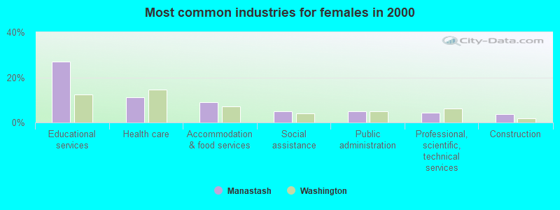
- Educational services (27.0%)
- Health care (11.3%)
- Accommodation & food services (9.0%)
- Social assistance (5.0%)
- Public administration (4.8%)
- Professional, scientific, technical services (4.4%)
- Construction (3.6%)
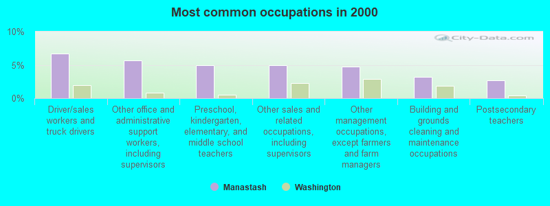
- Driver/sales workers and truck drivers (6.7%)
- Other office and administrative support workers, including supervisors (5.7%)
- Preschool, kindergarten, elementary, and middle school teachers (5.0%)
- Other sales and related occupations, including supervisors (5.0%)
- Other management occupations, except farmers and farm managers (4.8%)
- Building and grounds cleaning and maintenance occupations (3.2%)
- Postsecondary teachers (2.6%)
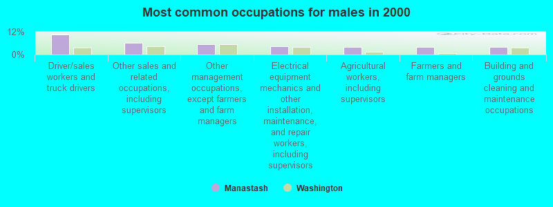
- Driver/sales workers and truck drivers (10.5%)
- Other sales and related occupations, including supervisors (6.1%)
- Other management occupations, except farmers and farm managers (5.3%)
- Electrical equipment mechanics and other installation, maintenance, and repair workers, including supervisors (4.3%)
- Agricultural workers, including supervisors (4.1%)
- Farmers and farm managers (3.9%)
- Building and grounds cleaning and maintenance occupations (3.9%)
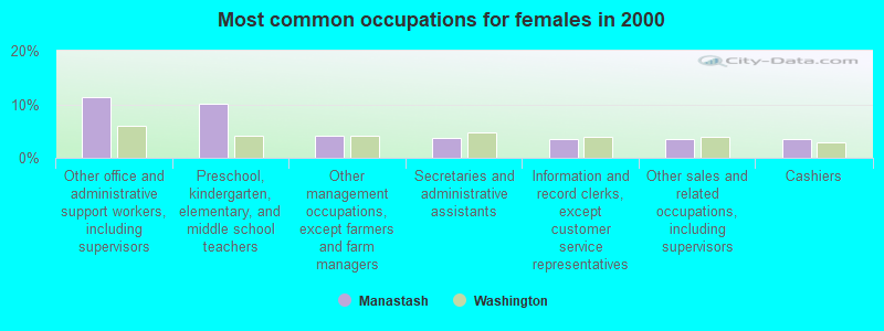
- Other office and administrative support workers, including supervisors (11.4%)
- Preschool, kindergarten, elementary, and middle school teachers (10.0%)
- Other management occupations, except farmers and farm managers (4.1%)
- Secretaries and administrative assistants (3.7%)
- Information and record clerks, except customer service representatives (3.6%)
- Other sales and related occupations, including supervisors (3.6%)
- Cashiers (3.5%)
Average climate in Manastash, Washington
Based on data reported by over 4,000 weather stations


(lower is better)
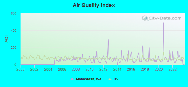
Air Quality Index (AQI) level in 2022 was 77.4. This is about average.
| City: | 77.4 |
| U.S.: | 72.6 |
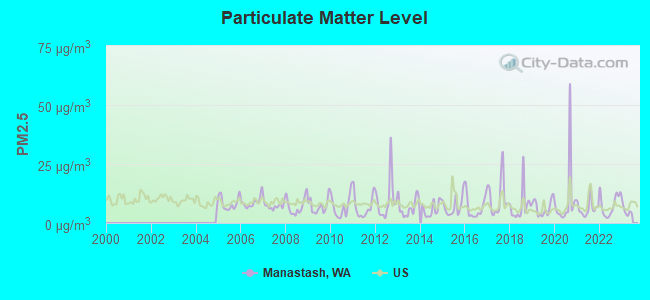
Particulate Matter (PM2.5) [µg/m3] level in 2022 was 7.60. This is about average. Closest monitor was 15.2 miles away from the city center.
| City: | 7.60 |
| U.S.: | 8.11 |
Earthquake activity:
Manastash-area historical earthquake activity is significantly above Washington state average. It is 1372% greater than the overall U.S. average.On 4/13/1949 at 19:55:42, a magnitude 7.0 (7.0 UK, Class: Major, Intensity: VIII - XII) earthquake occurred 78.6 miles away from Manastash center, causing $80,000,000 total damage
On 2/28/2001 at 18:54:32, a magnitude 6.8 (6.5 MB, 6.6 MS, 6.8 MW, Class: Strong, Intensity: VII - IX) earthquake occurred 81.5 miles away from the city center, causing $2,000,000,000 total damage and $305,000,000 insured losses
On 2/28/2001 at 18:54:32, a magnitude 6.8 (6.8 MD, Depth: 32.2 mi) earthquake occurred 88.5 miles away from the city center
On 4/29/1965 at 15:28:43, a magnitude 6.6 (6.6 UK) earthquake occurred 71.8 miles away from Manastash center, causing $28,000,000 total damage
On 10/28/1983 at 14:06:06, a magnitude 7.3 (6.2 MB, 7.3 MS, 7.0 MW) earthquake occurred 398.7 miles away from Manastash center, causing 2 deaths (2 shaking deaths) and 3 injuries, causing $15,000,000 total damage
On 7/3/1999 at 01:43:54, a magnitude 5.8 (5.4 MB, 5.5 MS, 5.8 MW, 5.3 ME, Depth: 25.2 mi, Class: Moderate, Intensity: VI - VII) earthquake occurred 112.3 miles away from the city center
Magnitude types: body-wave magnitude (MB), duration magnitude (MD), energy magnitude (ME), surface-wave magnitude (MS), moment magnitude (MW)
Natural disasters:
The number of natural disasters in Kittitas County (17) is near the US average (15).Major Disasters (Presidential) Declared: 14
Emergencies Declared: 2
Causes of natural disasters: Floods: 10, Storms: 6, Mudslides: 4, Landslides: 3, Winter Storms: 3, Fires: 2, Winds: 2, Drought: 1, Earthquake: 1, Heavy Rain: 1, Hurricane: 1, Volcanic Eruption: 1, Other: 1 (Note: some incidents may be assigned to more than one category).
Hospitals and medical centers near Manastash:
Colleges/universities with over 2000 students nearest to Manastash:
- Central Washington University (about 16 miles; Ellensburg, WA; Full-time enrollment: 10,960)
- Wenatchee Valley College (about 36 miles; Wenatchee, WA; FT enrollment: 2,951)
- Yakima Valley Community College (about 37 miles; Yakima, WA; FT enrollment: 3,632)
- Green River Community College (about 65 miles; Auburn, WA; FT enrollment: 7,425)
- Pierce College at Puyallup (about 68 miles; Puyallup, WA; FT enrollment: 2,529)
- Renton Technical College (about 69 miles; Renton, WA; FT enrollment: 2,549)
- Bellevue College (about 71 miles; Bellevue, WA; FT enrollment: 10,940)
Points of interest:
Notable locations in Manastash: Tamarack Spring Campground (A), South Fork Meadow Trailhead (B), Lavender (C), Barnes Cabin (D), Taneum Campground (E), Longmile Meadows Campground (F), Kaner Flat Campground (G), Horlick (H), Taneum Guard Station (I), Little Naches Summer Homes (J), Manastash Cow Camp (K), Milk Pond Picnic Grounds (L), Ellensburg Golf Club (M), High Valley Ranch (N), Naches Pass Campsite (O), Big Creek Lookout (P), Cle Elum Point Lookout (Q), Manastash Lookout (R), North Ridge Lookout (S), Pyramid Peak Lookout (T). Display/hide their locations on the map
Cemetery: Thorp Cemetery (1). Display/hide its location on the map
Lakes: Shoestring Lake (A), Devils Slide Lake (B), Taneum Lake (C), Lily Pond Lake (D), Manastash Lake (E), Lost Lake (F), Lavender Lake (G), Milk Lake (H). Display/hide their locations on the map
Rivers and creeks: Bear Creek (A), Big Creek (B), Blowout Creek (C), Butte Creek (D), Case Knife Creek (E), Cedar Creek (F), Cole Creek (G), Cub Creek (H), Disappointment Creek (I). Display/hide their locations on the map
| This place: | 2.6 people |
| Washington: | 2.5 people |
| This place: | 67.2% |
| Whole state: | 66.5% |
| This place: | 4.7% |
| Whole state: | 6.1% |
Likely homosexual households (counted as self-reported same-sex unmarried-partner households)
- Lesbian couples: 0.2% of all households
- Gay men: 0.2% of all households
| This place: | 5.8% |
| Whole state: | 10.6% |
| This place: | 2.1% |
| Whole state: | 4.6% |
For population 15 years and over in Manastash:
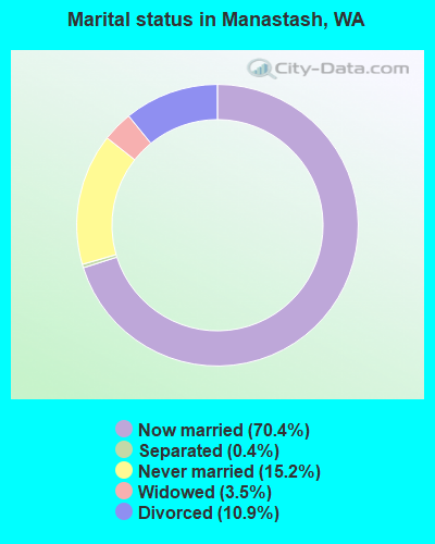
- Never married: 15.2%
- Now married: 70.4%
- Separated: 0.4%
- Widowed: 3.5%
- Divorced: 10.9%
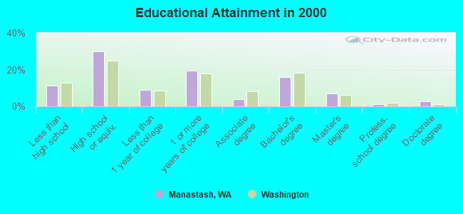
For population 25 years and over in Manastash:
- High school or higher: 88.8%
- Bachelor's degree or higher: 26.8%
- Graduate or professional degree: 10.7%
- Unemployed: 6.5%
- Mean travel time to work (commute): 27.9 minutes
| Here: | 10.4 |
| Washington average: | 11.3 |
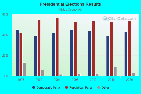
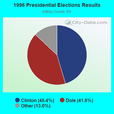
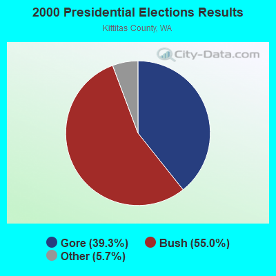
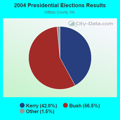
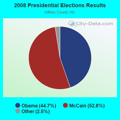
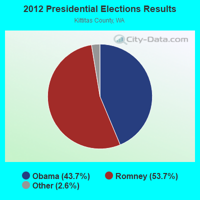
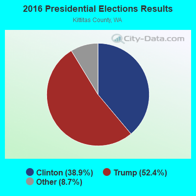

Graphs represent county-level data. Detailed 2008 Election Results
Religion statistics for Manastash, WA (based on Kittitas County data)
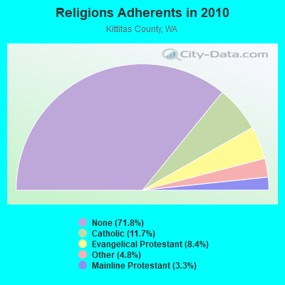
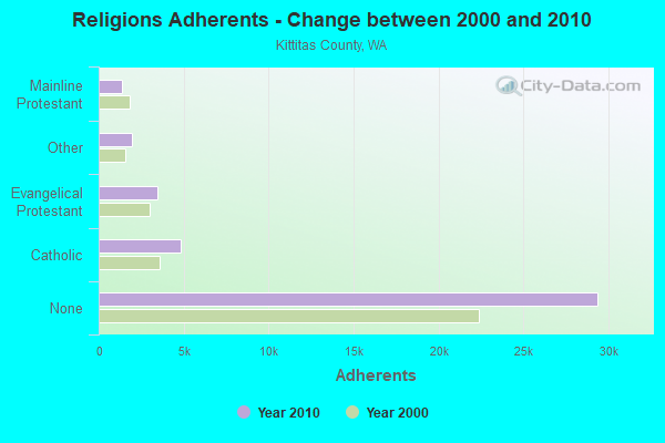
| Religion | Adherents | Congregations |
|---|---|---|
| Catholic | 4,800 | 3 |
| Evangelical Protestant | 3,427 | 25 |
| Other | 1,973 | 10 |
| Mainline Protestant | 1,346 | 11 |
| None | 29,369 | - |
Food Environment Statistics:
| Kittitas County: | 3.14 / 10,000 pop. |
| State: | 2.06 / 10,000 pop. |
| This county: | 0.26 / 10,000 pop. |
| Washington: | 0.19 / 10,000 pop. |
| This county: | 0.79 / 10,000 pop. |
| State: | 1.18 / 10,000 pop. |
| Kittitas County: | 4.98 / 10,000 pop. |
| Washington: | 2.67 / 10,000 pop. |
| Kittitas County: | 13.36 / 10,000 pop. |
| State: | 8.26 / 10,000 pop. |
| Kittitas County: | 6.2% |
| Washington: | 7.7% |
| Kittitas County: | 21.8% |
| Washington: | 25.7% |
| Here: | 11.4% |
| Washington: | 13.9% |
Strongest AM radio stations in Manastash:
- KTBI (810 AM; daytime; 50 kW; EPHRATA, WA; Owner: TACOMA BROADCASTERS, INCORPORATED)
- KIRO (710 AM; 50 kW; SEATTLE, WA; Owner: ENTERCOM SEATTLE LICENSE, LLC)
- KIXI (880 AM; 50 kW; MERCER ISLAND/SEATTL, WA; Owner: BELLEVUE RADIO, INC.)
- KTTH (770 AM; 50 kW; SEATTLE, WA; Owner: ENTERCOM SEATTLE LICENSE, LLC)
- KJR (950 AM; 50 kW; SEATTLE, WA)
- KGNW (820 AM; 50 kW; BURIEN-SEATTLE, WA; Owner: INSPIRATION MEDIA, INC.)
- KYAK (930 AM; 10 kW; YAKIMA, WA)
- KOMO (1000 AM; 50 kW; SEATTLE, WA; Owner: FISHER BROADCASTING - SEATTLE RADIO, L.L.C.)
- KYCW (1090 AM; 50 kW; SEATTLE, WA; Owner: INFINITY RADIO SUBSIDIARY OPERATIONS INC.)
- KPQ (560 AM; 5 kW; WENATCHEE, WA; Owner: WESTCOAST BROADCASTING CO.)
- KRKO (1380 AM; 50 kW; EVERETT, WA; Owner: S-R BROADCASTING, CO.)
- KJOX (980 AM; 5 kW; SELAH, WA; Owner: NEW NORTHWEST BROADCASTERS, LLC)
- KKOL (1300 AM; 50 kW; SEATTLE, WA; Owner: INSPIRATION MEDIA, INC.)
Strongest FM radio stations in Manastash:
- KPQ-FM (102.1 FM; WENATCHEE, WA; Owner: WESCOAST BROADCASTING COMPANY)
- KNWR (90.7 FM; ELLENSBURG, WA; Owner: WASHINGTON STATE UNIVERSITY)
- KCSH (88.9 FM; ELLENSBURG, WA; Owner: LIFETALK RADIO, INC.)
- KXLE-FM (95.3 FM; ELLENSBURG, WA; Owner: KXLE, INC.)
- KQBE (103.1 FM; ELLENSBURG, WA; Owner: PEAK COMMUNICATIONS, INC.)
- K232CV (94.3 FM; ELLENSBURG, WA; Owner: CITICASTERS LICENSES, L.P.)
- KZTA (96.9 FM; NACHES, WA; Owner: BUTTERFIELD BROADCASTING CORP)
- KQSN (99.3 FM; NACHES, WA; Owner: CAPSTAR TX LIMITED PARTNERSHIP)
- KOHO-FM (101.1 FM; LEAVENWORTH, WA; Owner: ICICLE BROADCASTING, INC.)
- KFFM (107.3 FM; YAKIMA, WA; Owner: CITICASTERS LICENSES, L.P.)
- K201EX (88.1 FM; GREENWATER, WA; Owner: CALVARY CHAPEL OF TWIN FALLS, INC.)
- KPLW (89.9 FM; WENATCHEE, WA; Owner: GROWING CHRISTIAN FOUNDATION)
- KRSE (105.7 FM; YAKIMA, WA; Owner: NEW NORTHWEST BROADCASTERS, LLC)
- KZOK-FM (102.5 FM; SEATTLE, WA; Owner: INFINITY RADIO SUBSIDIARY OPERATIONS INC.)
- KMPS-FM (94.1 FM; SEATTLE, WA; Owner: INFINITY RADIO SUBSIDIARY OPERATIONS INC.)
- KBKS (106.1 FM; TACOMA, WA; Owner: INFINITY RADIO SUBSIDIARY OPERATIONS INC.)
- KING-FM (98.1 FM; SEATTLE, WA; Owner: CLASSIC RADIO, INC.)
- KLSY-FM (92.5 FM; BELLEVUE, WA; Owner: BELLEVUE RADIO INC.)
- KPLU-FM (88.5 FM; TACOMA, WA; Owner: PACIFIC LUTHERAN UNIVERSITY, INC.)
- KWJZ (98.9 FM; SEATTLE, WA; Owner: ORCA RADIO, INC.)
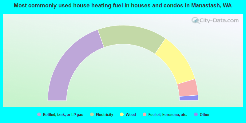
- 39.1%Bottled, tank, or LP gas
- 30.0%Electricity
- 21.6%Wood
- 7.0%Fuel oil, kerosene, etc.
- 1.3%Utility gas
- 1.0%Other fuel
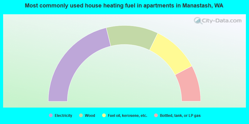
- 42.3%Electricity
- 22.1%Wood
- 20.2%Fuel oil, kerosene, etc.
- 15.4%Bottled, tank, or LP gas
Manastash compared to Washington state average:
- Unemployed percentage below state average.
- Black race population percentage significantly below state average.
- Hispanic race population percentage significantly below state average.
- Median age significantly above state average.
- Foreign-born population percentage significantly below state average.
- Renting percentage significantly below state average.
- Length of stay since moving in significantly above state average.
- Number of rooms per house significantly below state average.
- House age significantly below state average.