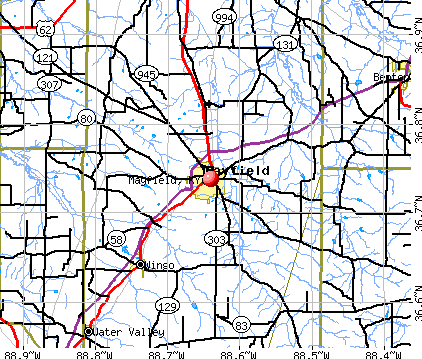
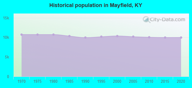
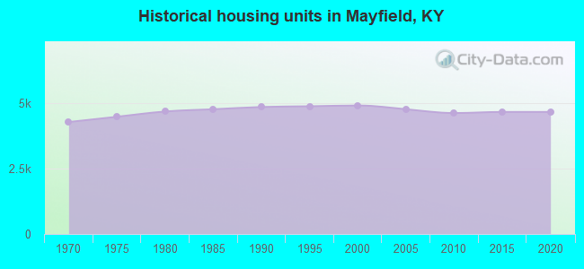
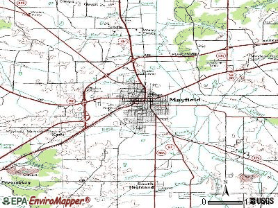
Mayfield, Kentucky
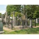
Mayfield: Wooldridge Monuments in Maplewood Cemetery

Mayfield: Wooldridge Monuments in Maplewood Cemetery
Mayfield: Mayfield, Ky

Mayfield: Wooldridge Monuments in Maplewood Cemetery
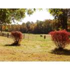
Mayfield: The beautiful country side, Mayfield. Ky

Mayfield: The beautiful country side, Mayfield. Ky

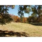
Mayfield: Sunrise
Mayfield: Mayfield, Ky
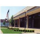
Mayfield: Mayfield City Hall
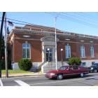
Mayfield: Mayfield Post Office
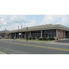
Mayfield: Mayfield Police Dept. Glory Day's 2013
- see
17
more - add
your
Submit your own pictures of this city and show them to the world
- OSM Map
- General Map
- Google Map
- MSN Map
Population change since 2000: -4.4%
 |
| Males: 4,821 | |
| Females: 5,073 |
| Median resident age: | 36.9 years |
| Kentucky median age: | 39.4 years |
Zip codes: 42066.
| Mayfield: | $41,993 |
| KY: | $59,341 |
Estimated per capita income in 2022: $26,656 (it was $15,327 in 2000)
Mayfield city income, earnings, and wages data
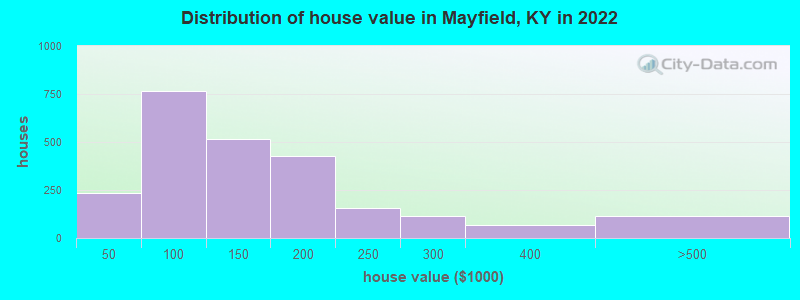
Estimated median house or condo value in 2022: $125,987 (it was $56,900 in 2000)
| Mayfield: | $125,987 |
| KY: | $196,300 |
Mean prices in 2022: all housing units: $185,490; detached houses: $197,254; townhouses or other attached units: $115,604; mobile homes: $84,697; occupied boats, rvs, vans, etc.: $80,579
Median gross rent in 2022: $574.
(31.4% for White Non-Hispanic residents, 22.6% for Black residents, 37.5% for Hispanic or Latino residents, 20.5% for other race residents, 67.7% for two or more races residents)
Detailed information about poverty and poor residents in Mayfield, KY


- 6,86668.4%White alone
- 1,38313.8%Hispanic
- 1,17811.7%Black alone
- 6766.7%Two or more races
- 320.3%Asian alone
- 120.1%Other race alone
Races in Mayfield detailed stats: ancestries, foreign born residents, place of birth
According to our research of Kentucky and other state lists, there were 60 registered sex offenders living in Mayfield, Kentucky as of May 05, 2024.
The ratio of all residents to sex offenders in Mayfield is 169 to 1.
Type |
2009 |
2010 |
2011 |
2012 |
2013 |
2014 |
2015 |
2016 |
2017 |
2018 |
2019 |
2020 |
2021 |
2022 |
|---|---|---|---|---|---|---|---|---|---|---|---|---|---|---|
| Murders (per 100,000) | 0 (0.0) | 0 (0.0) | 1 (9.9) | 0 (0.0) | 0 (0.0) | 0 (0.0) | 0 (0.0) | 0 (0.0) | 1 (10.0) | 0 (0.0) | 2 (20.3) | 0 (0.0) | 1 (10.4) | 0 (0.0) |
| Rapes (per 100,000) | 5 (49.2) | 6 (59.9) | 9 (89.2) | 2 (19.7) | 4 (39.4) | 1 (9.9) | 3 (29.6) | 6 (59.5) | 4 (40.0) | 3 (30.6) | 11 (111.7) | 6 (61.3) | 7 (72.6) | 7 (70.2) |
| Robberies (per 100,000) | 4 (39.3) | 7 (69.8) | 8 (79.3) | 3 (29.5) | 9 (88.7) | 4 (39.5) | 6 (59.2) | 10 (99.1) | 11 (110.1) | 10 (101.8) | 8 (81.2) | 11 (112.3) | 6 (62.2) | 3 (30.1) |
| Assaults (per 100,000) | 21 (206.6) | 20 (199.5) | 9 (89.2) | 13 (128.0) | 20 (197.2) | 8 (79.0) | 17 (167.6) | 11 (109.1) | 23 (230.2) | 22 (224.1) | 19 (192.9) | 20 (204.3) | 15 (155.5) | 11 (110.4) |
| Burglaries (per 100,000) | 77 (757.4) | 101 (1,008) | 75 (743.1) | 57 (561.3) | 64 (631.1) | 62 (612.0) | 69 (680.4) | 75 (743.6) | 130 (1,301) | 87 (886.0) | 79 (801.9) | 80 (817.1) | 78 (808.5) | 66 (662.3) |
| Thefts (per 100,000) | 183 (1,800) | 169 (1,686) | 140 (1,387) | 101 (994.6) | 189 (1,864) | 218 (2,152) | 216 (2,130) | 232 (2,300) | 390 (3,904) | 353 (3,595) | 330 (3,350) | 276 (2,819) | 221 (2,291) | 151 (1,515) |
| Auto thefts (per 100,000) | 12 (118.0) | 10 (99.8) | 10 (99.1) | 9 (88.6) | 6 (59.2) | 8 (79.0) | 10 (98.6) | 22 (218.1) | 21 (210.2) | 18 (183.3) | 26 (263.9) | 14 (143.0) | 23 (238.4) | 13 (130.4) |
| Arson (per 100,000) | 2 (19.7) | 2 (20.0) | 0 (0.0) | 1 (9.8) | 1 (9.9) | 0 (0.0) | 0 (0.0) | 2 (19.8) | 1 (10.0) | 1 (10.2) | 0 (0.0) | 2 (20.4) | 0 (0.0) | 0 (0.0) |
| City-Data.com crime index | 226.9 | 254.7 | 248.2 | 136.4 | 221.1 | 170.8 | 215.7 | 260.7 | 395.2 | 320.3 | 404.1 | 305.0 | 295.8 | 204.7 |
The City-Data.com crime index weighs serious crimes and violent crimes more heavily. Higher means more crime, U.S. average is 246.1. It adjusts for the number of visitors and daily workers commuting into cities.
Crime rate in Mayfield detailed stats: murders, rapes, robberies, assaults, burglaries, thefts, arson
Full-time law enforcement employees in 2021, including police officers: 24 (23 officers - 22 male; 1 female).
| Officers per 1,000 residents here: | 2.38 |
| Kentucky average: | 1.89 |
 Recent articles from our blog. Our writers, many of them Ph.D. graduates or candidates, create easy-to-read articles on a wide variety of topics.

 | A year ago today, the Mayfield tornado (3 replies) |
| Mayfield High School Football, Part II (0 replies) |
| Gotta put in a plug for Mayfield Cardinal Football (1 reply) |
| Mayfield,Kentucky (14 replies) |
| Crime in Mayfield KY? (11 replies) |
| December 11, 2021 Deadly Tornado System (94 replies) |
Latest news from Mayfield, KY collected exclusively by city-data.com from local newspapers, TV, and radio stations
Ancestries: English (28.4%), American (10.8%), German (4.3%), African (3.9%), Irish (3.3%), European (1.8%).
Current Local Time: CST time zone
Incorporated on 01/31/1846
Elevation: 470 feet
Land area: 6.68 square miles.
Population density: 1,482 people per square mile (low).
489 residents are foreign born (4.4% Latin America).
| This city: | 4.9% |
| Kentucky: | 4.1% |
Median real estate property taxes paid for housing units with mortgages in 2022: $990 (0.7%)
Median real estate property taxes paid for housing units with no mortgage in 2022: $602 (0.5%)
Nearest city with pop. 50,000+: Clarksville, TN  (72.2 miles , pop. 103,455).
Nearest city with pop. 200,000+: Metropolitan Government, TN (111.8 miles , pop. 569,891).
Nearest city with pop. 1,000,000+: Chicago, IL (356.7 miles , pop. 2,896,016).
Nearest cities:
), ), ), ), ), ), ), Latitude: 36.74 N, Longitude: 88.64 W
Daytime population change due to commuting: +3,110 (+31.0%)
Workers who live and work in this city: 2,183 (57.1%)
Area code: 270
Mayfield, Kentucky accommodation & food services, waste management - Economy and Business Data
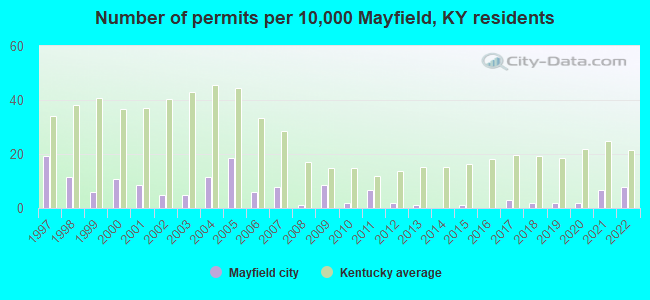
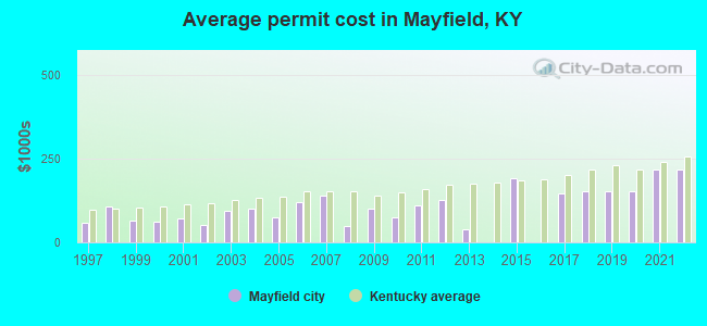
Single-family new house construction building permits:
- 2022: 8 buildings, average cost: $217,500
- 2021: 7 buildings, average cost: $217,500
- 2020: 2 buildings, average cost: $152,000
- 2019: 2 buildings, average cost: $152,000
- 2018: 2 buildings, average cost: $152,000
- 2017: 3 buildings, average cost: $144,700
- 2015: 1 building, cost: $191,600
- 2013: 1 building, cost: $40,000
- 2012: 2 buildings, average cost: $125,000
- 2011: 7 buildings, average cost: $109,000
- 2010: 2 buildings, average cost: $73,300
- 2009: 9 buildings, average cost: $100,200
- 2008: 1 building, cost: $50,000
- 2007: 8 buildings, average cost: $138,800
- 2006: 6 buildings, average cost: $121,200
- 2005: 19 buildings, average cost: $73,500
- 2004: 12 buildings, average cost: $100,900
- 2003: 5 buildings, average cost: $94,800
- 2002: 5 buildings, average cost: $51,000
- 2001: 9 buildings, average cost: $69,700
- 2000: 11 buildings, average cost: $62,200
- 1999: 6 buildings, average cost: $66,300
- 1998: 12 buildings, average cost: $107,200
- 1997: 20 buildings, average cost: $58,900
| Here: | 3.7% |
| Kentucky: | 3.8% |
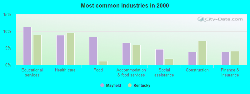
- Educational services (11.3%)
- Health care (8.8%)
- Food (8.4%)
- Accommodation & food services (6.6%)
- Social assistance (4.6%)
- Construction (3.9%)
- Finance & insurance (3.8%)
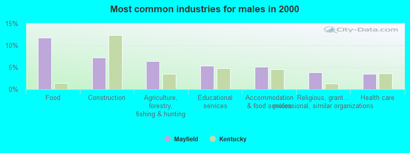
- Food (11.8%)
- Construction (7.2%)
- Agriculture, forestry, fishing & hunting (6.4%)
- Educational services (5.4%)
- Accommodation & food services (5.1%)
- Religious, grantmaking, civic, professional, similar organizations (3.8%)
- Health care (3.4%)
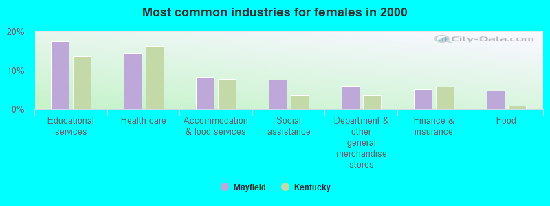
- Educational services (17.5%)
- Health care (14.5%)
- Accommodation & food services (8.2%)
- Social assistance (7.6%)
- Department & other general merchandise stores (6.0%)
- Finance & insurance (5.2%)
- Food (4.8%)
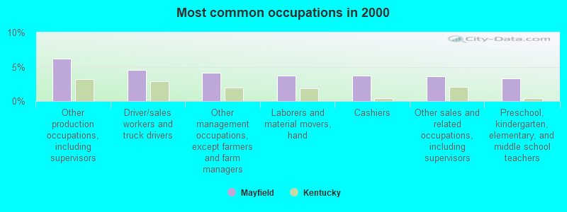
- Other production occupations, including supervisors (6.2%)
- Driver/sales workers and truck drivers (4.5%)
- Other management occupations, except farmers and farm managers (4.1%)
- Laborers and material movers, hand (3.7%)
- Cashiers (3.7%)
- Other sales and related occupations, including supervisors (3.6%)
- Preschool, kindergarten, elementary, and middle school teachers (3.3%)
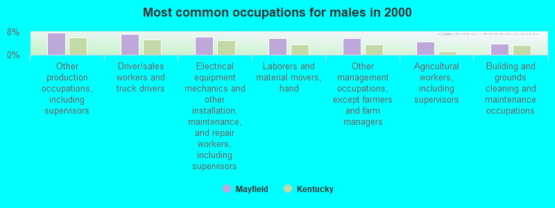
- Other production occupations, including supervisors (7.8%)
- Driver/sales workers and truck drivers (7.2%)
- Electrical equipment mechanics and other installation, maintenance, and repair workers, including supervisors (6.3%)
- Laborers and material movers, hand (5.8%)
- Other management occupations, except farmers and farm managers (5.8%)
- Agricultural workers, including supervisors (4.6%)
- Building and grounds cleaning and maintenance occupations (3.8%)
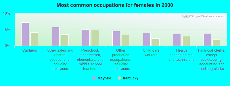
- Cashiers (7.1%)
- Other sales and related occupations, including supervisors (5.8%)
- Preschool, kindergarten, elementary, and middle school teachers (5.0%)
- Other production occupations, including supervisors (4.5%)
- Child care workers (4.0%)
- Health technologists and technicians (3.8%)
- Financial clerks, except bookkeeping, accounting and auditing clerks (3.8%)
Average climate in Mayfield, Kentucky
Based on data reported by over 4,000 weather stations


|
|


(lower is better)
Air Quality Index (AQI) level in 2022 was 70.9. This is about average.
| City: | 70.9 |
| U.S.: | 72.6 |
Carbon Monoxide (CO) [ppm] level in 2000 was 0.102. This is significantly better than average. Closest monitor was 22.5 miles away from the city center.
| City: | 0.102 |
| U.S.: | 0.251 |
Nitrogen Dioxide (NO2) [ppb] level in 2022 was 5.10. This is about average. Closest monitor was 0.1 miles away from the city center.
| City: | 5.10 |
| U.S.: | 5.11 |
Sulfur Dioxide (SO2) [ppb] level in 2022 was 0.675. This is significantly better than average. Closest monitor was 0.1 miles away from the city center.
| City: | 0.675 |
| U.S.: | 1.515 |
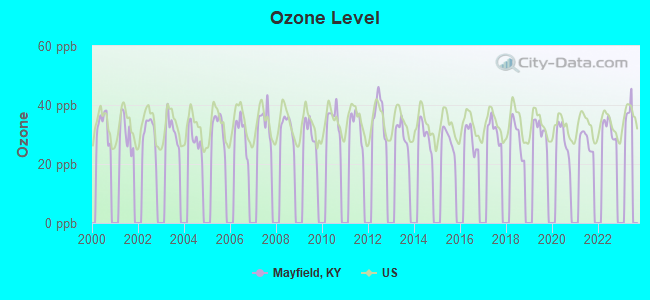
Ozone [ppb] level in 2022 was 32.1. This is about average. Closest monitor was 13.8 miles away from the city center.
| City: | 32.1 |
| U.S.: | 33.3 |
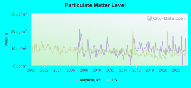
Particulate Matter (PM2.5) [µg/m3] level in 2022 was 9.30. This is about average. Closest monitor was 22.5 miles away from the city center.
| City: | 9.30 |
| U.S.: | 8.11 |
Tornado activity:
Mayfield-area historical tornado activity is slightly above Kentucky state average. It is 76% greater than the overall U.S. average.
On 3/4/1964, a category F4 (max. wind speeds 207-260 mph) tornado 10.9 miles away from the Mayfield city center killed 3 people and injured 24 people and caused between $50,000 and $500,000 in damages.
On 4/3/1968, a category F4 tornado 20.3 miles away from the city center killed 2 people and injured 30 people and caused between $500,000 and $5,000,000 in damages.
Earthquake activity:
Mayfield-area historical earthquake activity is significantly above Kentucky state average. It is 324% greater than the overall U.S. average.On 4/18/2008 at 09:36:59, a magnitude 5.4 (5.1 MB, 4.8 MS, 5.4 MW, 5.2 MW, Class: Moderate, Intensity: VI - VII) earthquake occurred 125.6 miles away from Mayfield center
On 9/26/1990 at 13:18:51, a magnitude 5.0 (4.7 MB, 4.8 LG, 5.0 LG, Depth: 7.7 mi) earthquake occurred 57.7 miles away from the city center
On 5/4/1991 at 01:18:54, a magnitude 5.0 (4.4 MB, 4.6 LG, 5.0 LG, Depth: 3.1 mi) earthquake occurred 66.7 miles away from the city center
On 4/18/2008 at 09:36:59, a magnitude 5.2 (5.2 MW, Depth: 8.9 mi) earthquake occurred 125.5 miles away from the city center
On 6/18/2002 at 17:37:15, a magnitude 5.0 (4.3 MB, 4.6 MW, 5.0 LG) earthquake occurred 98.5 miles away from Mayfield center
On 9/29/1987 at 00:04:56, a magnitude 4.6 (4.6 MB, 4.5 LG, Class: Light, Intensity: IV - V) earthquake occurred 30.2 miles away from the city center
Magnitude types: regional Lg-wave magnitude (LG), body-wave magnitude (MB), surface-wave magnitude (MS), moment magnitude (MW)
Natural disasters:
The number of natural disasters in Graves County (12) is smaller than the US average (15).Major Disasters (Presidential) Declared: 8
Emergencies Declared: 2
Causes of natural disasters: Floods: 7, Storms: 7, Tornadoes: 3, Winter Storms: 2, Blizzard: 1, Hurricane: 1, Landslide: 1, Mudslide: 1, Tropical Depression: 1, Wind: 1, Other: 1 (Note: some incidents may be assigned to more than one category).
Hospitals and medical centers in Mayfield:
- JACKSON PURCHASE MEDICAL CENTER (Government - Hospital District or Authority, provides emergency services, 1099 MEDICAL CENTER CIRCLE)
- CARE INN OF MAYFIELD ICF (FOURTH INDIANA ST)
- GREEN ACRES HEALTH CARE (402 W. FARTHING STREET)
- HERITAGE MANOR HEALTH CARE CENTER (401 INDIANA AVE)
- MILLS HEALTH AND REHAB CENTER, INC (500 BECK LANE)
- MILLS MANOR INC (500 BECK LANE)
- FMC - DIALYSIS OF MAYFIELD (1029 MEDICAL CENTER CIRCLE STE 301)
Airports located in Mayfield:
- Mayfield Graves County Airport (M25) (Runways: 1, Air Taxi Ops: 750, Itinerant Ops: 9,012, Local Ops: 4,200, Military Ops: 525)
College/University in Mayfield:
Colleges/universities with over 2000 students nearest to Mayfield:
- Murray State University (about 20 miles; Murray, KY; Full-time enrollment: 8,930)
- West Kentucky Community and Technical College (about 22 miles; Paducah, KY; FT enrollment: 4,107)
- The University of Tennessee-Martin (about 31 miles; Martin, TN; FT enrollment: 7,013)
- Bethel University (about 42 miles; McKenzie, TN; FT enrollment: 5,878)
- Southeast Missouri State University (about 64 miles; Cape Girardeau, MO; FT enrollment: 9,678)
- Dyersburg State Community College (about 64 miles; Dyersburg, TN; FT enrollment: 2,211)
- Hopkinsville Community College (about 65 miles; Hopkinsville, KY; FT enrollment: 2,269)
Public high schools in Mayfield:
- GRAVES COUNTY HIGH SCHOOL (Students: 1,354, Location: 1220 EAGLES WAY, Grades: 9-12)
- MAYFIELD HIGH SCHOOL (Students: 414, Location: 700 DOUTHITT ST, Grades: 9-12)
- MAYFIELD YOUTH DEVELOPMENT CENTER (Location: 3179 STATE RT 45 S, Grades: 8-12)
- GATEWAY ACADEMY HIGH SCHOOL (Location: 100 E. LOCKRIDGE ST., Grades: 10-12)
Private high school in Mayfield:
Public elementary/middle schools in Mayfield:
- MAYFIELD ELEMENTARY SCHOOL (Students: 731, Location: 1004 BACKUSBURG RD, Grades: PK-5)
- GRAVES COUNTY MIDDLE SCHOOL (Students: 697, Location: 625 JIMTOWN RD, Grades: 7-8)
- GRAVES COUNTY CENTRAL ELEMENTARY (Students: 425, Location: 2262 STATE RT 121 N, Grades: PK-6)
- MAYFIELD MIDDLE SCHOOL (Students: 347, Location: 112 W COLLEGE ST, Grades: 6-8)
- SEDALIA ELEMENTARY SCHOOL (Location: 5252 ST. RT 97, Grades: PK-6)
Private elementary/middle school in Mayfield:
Points of interest:
Notable locations in Mayfield: County War Memorial Fairgrounds (A), Mayfield Fire Department Station 1 (B), Kentucky Division of Forestry Western District (C), Mayfield Fire and Rescue Station (D), Mayfield Fire Department Station 3 (E), Mayfield Fire Department Station 2 (F), Mayfield - Graves County Ambulance Service (G). Display/hide their locations on the map
Cemeteries: Maplewood Cemetery (1), Highland Park Cemetery (2), Saint Josephs Cemetery (3). Display/hide their locations on the map
Tourist attractions: Tutoring Service (Cultural Attractions- Events- & Facilities; 227 State Route 1748 East), Mayfield-Graves County Chamber of Commerce (201 East College Street).
Hotels: Days Inn (1101 W Housman St), Budget Inn (513 East Broadway Street), Motel Budget (513 East Broadway Street), Mayfield Motor Inn (1860 State Route 58 East), Super 8 Motel (1100 Links Lane).
Courts: Kentucky State - Administrative Office Of The Courts- Court Of Appeals (2380 State Route 45 North), Kentucky State - Circuit Judge- Administrative Office Of The Courts- Court Repo (Court House), Graves County - Court Designated Worker (Court House), Graves County - District Court Administrator (Court House), Kennemore Barry G C Court Clerk (101 East South Street Suite 2).
Birthplace of: Phil Cutchin - Football player and coach, Darren Warren - Country music singer, Robert McCarley - Psychiatrist, A.J. Adams - College basketball player (Murray State Racers), David Boaz - Book editor, Kent Robbins - Country songwriter, Randy Galloway - Radio personality.
Drinking water stations with addresses in Mayfield and their reported violations in the past:
MAYFIELD ELECTRIC & WATER (Population served: 10,349, Groundwater):Past monitoring violations:CONSUMERS WATER DISTRICT (Population served: 4,265, Purch groundwater):
- Follow-up Or Routine LCR Tap M/R - In OCT-11-2004, Contaminant: Lead and Copper Rule. Follow-up actions: St Public Notif requested (FEB-22-2005), St Formal NOV issued (FEB-22-2005), St Compliance achieved (DEC-19-2005), St Public Notif received (JAN-18-2006)
- One minor monitoring violation
- One regular monitoring violation
Past health violations:HICKORY WATER DISTRICT (Population served: 3,769, Groundwater):Past monitoring violations:
- MCL, Monthly (TCR) - In JAN-2007, Contaminant: Coliform. Follow-up actions: St Compliance achieved (MAR-21-2007), St Public Notif requested (APR-10-2007), St Formal NOV issued (APR-10-2007), St Public Notif received (MAY-30-2007)
- Monitoring and Reporting (DBP) - Between JAN-2005 and DEC-2005, Contaminant: TTHM. Follow-up actions: St Public Notif requested (FEB-13-2006), St Formal NOV issued (FEB-13-2006), St Public Notif received (JUN-29-2006), St Compliance achieved (SEP-12-2006)
- Monitoring and Reporting (DBP) - Between JAN-2005 and DEC-2005, Contaminant: Total Haloacetic Acids (HAA5). Follow-up actions: St Public Notif requested (FEB-13-2006), St Formal NOV issued (FEB-13-2006), St Public Notif received (JUN-29-2006), St Compliance achieved (SEP-12-2006)
- One regular monitoring violation
Past monitoring violations:SOUTH GRAVES CO WATER DISTRICT (Population served: 2,168, Groundwater):
- Monitoring and Reporting (DBP) - In FEB-01-2004, Contaminant: DBP Stage 1. Follow-up actions: St Public Notif requested (JUN-02-2005), St Formal NOV issued (JUN-02-2005), St Compliance achieved (AUG-22-2005), St Public Notif received (OCT-31-2005)
Past monitoring violations:FANCY FARM WATER DISTRICT (Population served: 1,408, Groundwater):
- Monitoring and Reporting (DBP) - Between JAN-2005 and DEC-2005, Contaminant: TTHM. Follow-up actions: St Public Notif requested (FEB-13-2006), St Formal NOV issued (FEB-13-2006), St Public Notif received (JUN-29-2006), St Compliance achieved (SEP-12-2006)
- Monitoring and Reporting (DBP) - Between JAN-2005 and DEC-2005, Contaminant: Total Haloacetic Acids (HAA5). Follow-up actions: St Public Notif requested (FEB-13-2006), St Formal NOV issued (FEB-13-2006), St Public Notif received (JUN-29-2006), St Compliance achieved (SEP-12-2006)
- Follow-up Or Routine LCR Tap M/R - In JAN-01-1996, Contaminant: Lead and Copper Rule. Follow-up actions: Fed Formal NOV issued (FEB-13-1998), Fed Compliance achieved (MAR-02-2011)
- One regular monitoring violation
Past monitoring violations:HARDEMAN WATER DISTRICT (Population served: 1,129, Purch groundwater):
- One minor monitoring violation
Past monitoring violations:
- Monitoring and Reporting (DBP) - In FEB-01-2004, Contaminant: DBP Stage 1. Follow-up actions: St Public Notif requested (JUN-02-2005), St Formal NOV issued (JUN-02-2005), St Compliance achieved (OCT-24-2005), St Public Notif received (OCT-24-2005)
- 3 regular monitoring violations
| This city: | 2.3 people |
| Kentucky: | 2.5 people |
| This city: | 58.7% |
| Whole state: | 66.9% |
| This city: | 6.1% |
| Whole state: | 6.4% |
Likely homosexual households (counted as self-reported same-sex unmarried-partner households)
- Lesbian couples: 0.2% of all households
- Gay men: 0.2% of all households
People in group quarters in Mayfield in 2010:
- 161 people in nursing facilities/skilled-nursing facilities
- 82 people in local jails and other municipal confinement facilities
- 30 people in emergency and transitional shelters (with sleeping facilities) for people experiencing homelessness
- 20 people in residential treatment centers for adults
- 9 people in group homes intended for adults
People in group quarters in Mayfield in 2000:
- 274 people in nursing homes
- 138 people in local jails and other confinement facilities (including police lockups)
- 22 people in other noninstitutional group quarters
- 21 people in homes or halfway houses for drug/alcohol abuse
- 8 people in homes for the mentally retarded
- 7 people in training schools for juvenile delinquents
Banks with branches in Mayfield (2011 data):
- First Kentucky Bank, Inc.: Drive-Up Facility, at 223 South Sixth Street, South Office Branch. Info updated 2006/10/25: Bank assets: $369.9 mil, Deposits: $313.6 mil, local headquarters, positive income, 11 total offices, Holding Company: Exchange Bancshares, Inc.
- FNB Bank, Inc.: Mayfield Banking Center Branch at 310 Charles Drive, branch established on 1998/01/08; Fnb Bank, Inc. at 7th And Broadway, branch established on 1875/01/01. Info updated 2010/10/01: Bank assets: $371.8 mil, Deposits: $311.4 mil, local headquarters, positive income, Commercial Lending Specialization, 8 total offices, Holding Company: Jackson Financial Corporation
- Regions Bank: Downtown Branch at 117 North Seventh Street, branch established on 1974/08/19; Plaza Branch at 1104 Paris Road, branch established on 1956/03/01. Info updated 2011/02/24: Bank assets: $123,368.2 mil, Deposits: $98,301.3 mil, headquarters in Birmingham, AL, positive income, Commercial Lending Specialization, 1778 total offices, Holding Company: Regions Financial Corporation
- U.S. Bank National Association: Mayfield Branch at 406 South Seventh Street, branch established on 1898/01/01; Mayfield Walmart Branch at 1225 Paris Road, branch established on 1996/10/16. Info updated 2012/01/30: Bank assets: $330,470.8 mil, Deposits: $236,091.5 mil, headquarters in Cincinnati, OH, positive income, 3121 total offices, Holding Company: U.S. Bancorp
For population 15 years and over in Mayfield:
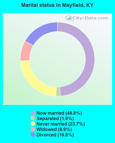
- Never married: 23.7%
- Now married: 48.8%
- Separated: 1.9%
- Widowed: 8.9%
- Divorced: 16.8%
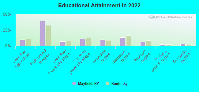
For population 25 years and over in Mayfield:
- High school or higher: 90.1%
- Bachelor's degree or higher: 22.0%
- Graduate or professional degree: 9.7%
- Unemployed: 7.5%
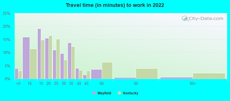
- Mean travel time to work (commute): 13.9 minutes
| Here: | 11.7 |
| Kentucky average: | 11.7 |
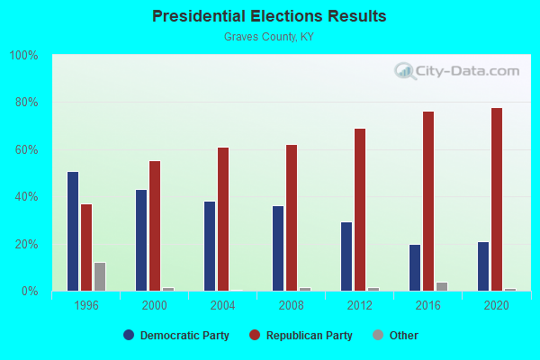
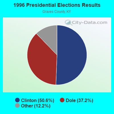
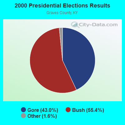
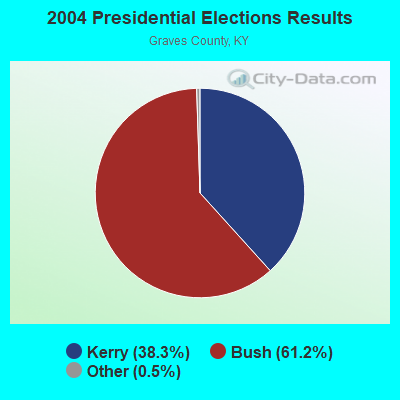
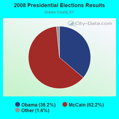
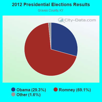
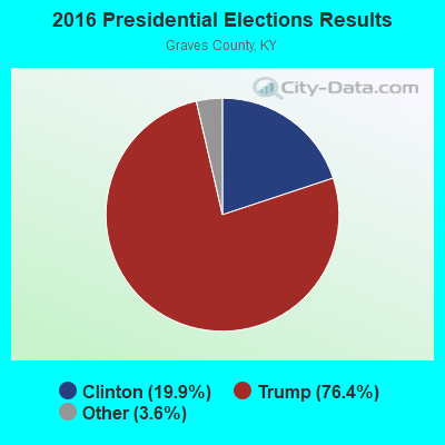
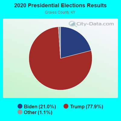
Graphs represent county-level data. Detailed 2008 Election Results
Religion statistics for Mayfield, KY (based on Graves County data)
| Religion | Adherents | Congregations |
|---|---|---|
| Evangelical Protestant | 22,543 | 84 |
| Mainline Protestant | 2,403 | 18 |
| Catholic | 2,196 | 2 |
| Black Protestant | 678 | 6 |
| Other | 331 | 3 |
| None | 8,970 | - |
Food Environment Statistics:
| This county: | 1.33 / 10,000 pop. |
| Kentucky: | 2.19 / 10,000 pop. |
| Graves County: | 0.27 / 10,000 pop. |
| Kentucky: | 0.25 / 10,000 pop. |
| Graves County: | 4.00 / 10,000 pop. |
| State: | 4.36 / 10,000 pop. |
| Graves County: | 5.87 / 10,000 pop. |
| State: | 5.74 / 10,000 pop. |
| Here: | 11.0% |
| Kentucky: | 11.0% |
| Here: | 32.1% |
| State: | 30.0% |
| Graves County: | 17.3% |
| State: | 15.9% |
Health and Nutrition:
| Mayfield: | 51.4% |
| State: | 49.9% |
| Mayfield: | 48.9% |
| Kentucky: | 47.0% |
| Here: | 28.5 |
| Kentucky: | 28.6 |
| This city: | 20.6% |
| Kentucky: | 21.0% |
| Here: | 11.1% |
| State: | 10.1% |
| Mayfield: | 6.9 |
| State: | 6.8 |
| Here: | 34.0% |
| Kentucky: | 33.8% |
| Mayfield: | 56.4% |
| Kentucky: | 56.8% |
| This city: | 78.0% |
| State: | 78.9% |
More about Health and Nutrition of Mayfield, KY Residents
| Local government employment and payroll (March 2022) | |||||
| Function | Full-time employees | Monthly full-time payroll | Average yearly full-time wage | Part-time employees | Monthly part-time payroll |
|---|---|---|---|---|---|
| Firefighters | 44 | $196,952 | $53,714 | 0 | $0 |
| Police Protection - Officers | 26 | $134,773 | $62,203 | 0 | $0 |
| Other and Unallocable | 17 | $41,613 | $29,374 | 0 | $0 |
| Streets and Highways | 13 | $49,737 | $45,911 | 0 | $0 |
| Water Supply | 8 | $29,396 | $44,094 | 0 | $0 |
| Electric Power | 8 | $50,752 | $76,128 | 0 | $0 |
| Sewerage | 7 | $30,732 | $52,683 | 0 | $0 |
| Other Government Administration | 6 | $20,219 | $40,438 | 8 | $598 |
| Financial Administration | 3 | $14,300 | $57,200 | 0 | $0 |
| Police - Other | 1 | $3,080 | $36,960 | 0 | $0 |
| Parks and Recreation | 0 | $0 | 1 | $230 | |
| Totals for Government | 133 | $571,554 | $51,569 | 9 | $828 |
Mayfield government finances - Expenditure in 2021 (per resident):
- Current Operations - Local Fire Protection: $2,767,000 ($279.66)
Central Staff Services: $1,826,000 ($184.56)
Police Protection: $1,566,000 ($158.28)
Regular Highways: $797,000 ($80.55)
General - Other: $219,000 ($22.13)
Public Welfare - Other: $149,000 ($15.06)
Parks and Recreation: $105,000 ($10.61)
- General - Interest on Debt: $6,000 ($0.61)
- Other Capital Outlay - Regular Highways: $342,000 ($34.57)
Police Protection: $256,000 ($25.87)
Local Fire Protection: $23,000 ($2.32)
Central Staff Services: $9,000 ($0.91)
- Total Salaries and Wages: $4,839,000 ($489.08)
Mayfield government finances - Revenue in 2021 (per resident):
- Charges - Other: $2,365,000 ($239.03)
- Federal Intergovernmental - Other: $923,000 ($93.29)
- Local Intergovernmental - Other: $1,000 ($0.10)
- Miscellaneous - Interest Earnings: $63,000 ($6.37)
Donations From Private Sources: $18,000 ($1.82)
Sale of Property: $13,000 ($1.31)
Fines and Forfeits: $10,000 ($1.01)
- State Intergovernmental - Other: $345,000 ($34.87)
Highways: $182,000 ($18.39)
General Local Government Support: $10,000 ($1.01)
- Tax - Individual Income: $4,193,000 ($423.79)
Property: $1,762,000 ($178.09)
Insurance Premiums Sales: $1,627,000 ($164.44)
Corporation Net Income: $691,000 ($69.84)
Alcoholic Beverage License: $417,000 ($42.15)
Public Utilities Sales: $315,000 ($31.84)
Other: $41,000 ($4.14)
Other Selective Sales: $35,000 ($3.54)
Other License: $6,000 ($0.61)
Mayfield government finances - Debt in 2021 (per resident):
- Long Term Debt - Beginning Outstanding - Public Debt for Private Purpose: $9,750,000 ($985.45)
Outstanding Nonguaranteed - Industrial Revenue: $9,750,000 ($985.45)
Beginning Outstanding - Unspecified Public Purpose: $280,000 ($28.30)
Retired Unspecified Public Purpose: $181,000 ($18.29)
Outstanding Unspecified Public Purpose: $99,000 ($10.01)
Mayfield government finances - Cash and Securities in 2021 (per resident):
- Other Funds - Cash and Securities: $6,606,000 ($667.68)
- Sinking Funds - Cash and Securities: $9,750,000 ($985.45)
| Businesses in Mayfield, KY | ||||
| Name | Count | Name | Count | |
|---|---|---|---|---|
| AT&T | 1 | Lane Furniture | 1 | |
| Advance Auto Parts | 1 | Lowe's | 1 | |
| Arby's | 1 | McDonald's | 1 | |
| AutoZone | 1 | Nike | 1 | |
| Burger King | 1 | Papa John's Pizza | 1 | |
| CVS | 1 | Penske | 1 | |
| Chevrolet | 1 | Pizza Hut | 1 | |
| Dairy Queen | 1 | RadioShack | 1 | |
| Days Inn | 1 | SONIC Drive-In | 1 | |
| Domino's Pizza | 1 | Subway | 2 | |
| FedEx | 2 | Super 8 | 1 | |
| Ford | 1 | True Value | 1 | |
| GNC | 1 | U-Haul | 1 | |
| Goodwill | 1 | UPS | 1 | |
| H&R Block | 1 | Walgreens | 1 | |
| Hardee's | 1 | Walmart | 1 | |
| KFC | 1 | Wendy's | 1 | |
| La-Z-Boy | 1 | YMCA | 1 | |
Strongest AM radio stations in Mayfield:
- WYMC (1430 AM; 1 kW; MAYFIELD, KY; Owner: JDM COMMUNICATIONS, INC.)
- WPAD (1560 AM; 10 kW; PADUCAH, KY; Owner: BRISTOL BROADCASTING COMPANY, INC.)
- WCBL (1290 AM; 5 kW; BENTON, KY; Owner: JIM W. FREELAND)
- WRKY (1130 AM; 2 kW; MURRAY, KY; Owner: FOREVER COMMUNICATIONS INC)
- WSM (650 AM; 50 kW; NASHVILLE, TN; Owner: GAYLORD ENTERTAINMENT COMPANY)
- WKYX (570 AM; 1 kW; PADUCAH, KY; Owner: BRISTOL BROADCASTING COMPANY, INC.)
- WMUF (1000 AM; daytime; 5 kW; PARIS, TN; Owner: BENTON-WEATHERFORD B/CTING OF TN,INC)
- WKDA (1200 AM; 50 kW; NASHVILLE, TN; Owner: RADIO NASHVILLE, INC.)
- WCRV (640 AM; 50 kW; COLLIERVILLE, TN; Owner: BOTT BROADCASTING COMPANY/TENNESSEE)
- WNQM (1300 AM; 50 kW; NASHVILLE, TN; Owner: WNQM. INC.)
- WAMB (1160 AM; 50 kW; DONELSON, TN; Owner: GREAT SOUTHERN BROADCASTING COMPANY, INC.)
- WGSF (1030 AM; 50 kW; MEMPHIS, TN; Owner: FLINN BROADCASTING CORPORATION)
- WDIA (1070 AM; 50 kW; MEMPHIS, TN; Owner: CLEAR CHANNEL BROADCASTING LICENSES, INC.)
Strongest FM radio stations in Mayfield:
- WLLE (94.7 FM; MAYFIELD, KY; Owner: FOREVER COMMUNICATIONS KY, LLC)
- WKBG (102.1 FM; CLINTON, KY; Owner: FOREVER COMMUNICATIONS INC)
- WKYQ (93.3 FM; PADUCAH, KY; Owner: BRISTOL BROADCASTING COMPANY, INC.)
- WDDJ (96.9 FM; PADUCAH, KY; Owner: BRISTOL BROADCASTING COMPANY, INC.)
- WKMS-FM (91.3 FM; MURRAY, KY; Owner: MURRAY STATE UNIVERSITY)
- WFGE (103.7 FM; MURRAY, KY; Owner: FOREVER COMMUNICATIONS INC)
- WBEL (88.5 FM; CAIRO, IL; Owner: AMERICAN FAMILY ASSOCIATION)
- WRIK-FM (98.3 FM; METROPOLIS, IL; Owner: SUN MEDIA, INC.)
- WZZL (106.7 FM; REIDLAND, KY; Owner: W. RUSSELL WITHERS, JR.)
- WCBL-FM (99.1 FM; BENTON, KY; Owner: JIM W. FREELAND)
- WTRT (88.1 FM; BENTON, KY; Owner: HEARTLAND MINISTRIES, INC.)
- WGKY (95.9 FM; WICKLIFFE, KY; Owner: WICKLIFE RENTAL PROPERTIES, INC.)
- WCCK (95.7 FM; CALVERT CITY, KY; Owner: JIM W. FREELAND DBA FREELAND BROADCASTING)
- WVHM (90.5 FM; BENTON, KY; Owner: HEARTLAND MINISTRIES, INC.)
- WAAJ (89.7 FM; BENTON, KY; Owner: HEARTLAND MINISTRIES, INC.)
TV broadcast stations around Mayfield:
- WKMU (Channel 21; MURRAY, KY; Owner: KENTUCKY AUTHORITY FOR EDUCATIONAL TV)
- WDKA (Channel 49; PADUCAH, KY; Owner: WDKA ACQUISITION CORPORATION)
- WPSD-TV (Channel 6; PADUCAH, KY; Owner: WPSD-TV, LLC)
- WQTV-LP (Channel 24; MURRAY, KY; Owner: RAYCOM AMERICA, INC.)
- WKPD (Channel 29; PADUCAH, KY; Owner: KENTUCKY AUTHORITY FOR EDUCATIONAL TV)
- W54AE (Channel 54; PADUCAH, KY; Owner: TRI-STATE CHRISTIAN TV, INC.)
- WQWQ-LP (Channel 9; PADUCAH, KY; Owner: RAYCOM AMERICA, INC.)
- National Bridge Inventory (NBI) Statistics
- 86Number of bridges
- 797ft / 243mTotal length
- $3,724,000Total costs
- 373,307Total average daily traffic
- 51,481Total average daily truck traffic
- New bridges - historical statistics
- 61920-1929
- 61930-1939
- 61940-1949
- 71950-1959
- 241960-1969
- 41970-1979
- 41980-1989
- 61990-1999
- 132000-2009
- 92010-2019
- 12020-2022
FCC Registered Antenna Towers: 112 (See the full list of FCC Registered Antenna Towers)
FCC Registered Commercial Land Mobile Towers: 2 (See the full list of FCC Registered Commercial Land Mobile Towers in Mayfield, KY)
FCC Registered Private Land Mobile Towers: 1 (See the full list of FCC Registered Private Land Mobile Towers)
FCC Registered Broadcast Land Mobile Towers: 17 (See the full list of FCC Registered Broadcast Land Mobile Towers)
FCC Registered Microwave Towers: 23 (See the full list of FCC Registered Microwave Towers in this town)
FCC Registered Paging Towers: 3 (See the full list of FCC Registered Paging Towers)
FCC Registered Maritime Coast & Aviation Ground Towers: 2 (See the full list of FCC Registered Maritime Coast & Aviation Ground Towers)
FCC Registered Amateur Radio Licenses: 52 (See the full list of FCC Registered Amateur Radio Licenses in Mayfield)
FAA Registered Aircraft: 11 (See the full list of FAA Registered Aircraft in Mayfield)
2002 - 2018 National Fire Incident Reporting System (NFIRS) incidents
- Fire incident types reported to NFIRS in Mayfield, KY
- 68449.4%Structure Fires
- 46333.5%Outside Fires
- 16511.9%Mobile Property/Vehicle Fires
- 725.2%Other
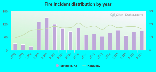 Based on the data from the years 2002 - 2018 the average number of fire incidents per year is 81. The highest number of fire incidents - 150 took place in 2006, and the least - 18 in 2004. The data has a growing trend.
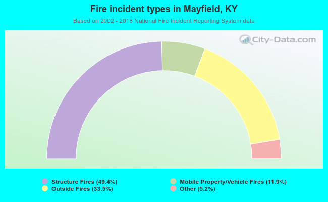 When looking into fire subcategories, the most reports belonged to: Structure Fires (49.4%), and Outside Fires (33.5%).
| Most common first names in Mayfield, KY among deceased individuals | ||
| Name | Count | Lived (average) |
|---|---|---|
| James | 325 | 72.5 years |
| Mary | 298 | 78.5 years |
| William | 234 | 75.0 years |
| John | 181 | 74.7 years |
| Robert | 165 | 73.4 years |
| Charles | 114 | 70.2 years |
| George | 87 | 76.3 years |
| Thomas | 85 | 75.4 years |
| Ruth | 71 | 80.4 years |
| Dorothy | 65 | 77.5 years |
| Most common last names in Mayfield, KY among deceased individuals | ||
| Last name | Count | Lived (average) |
|---|---|---|
| Smith | 140 | 78.1 years |
| Jones | 123 | 76.8 years |
| Wilson | 80 | 75.6 years |
| Jackson | 79 | 74.3 years |
| Williams | 67 | 76.5 years |
| Johnson | 60 | 77.2 years |
| Dowdy | 57 | 78.3 years |
| Adams | 55 | 73.7 years |
| Davis | 55 | 78.0 years |
| Thomas | 53 | 79.2 years |
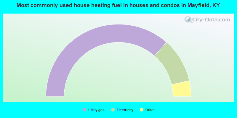
- 73.1%Utility gas
- 20.0%Electricity
- 3.8%Bottled, tank, or LP gas
- 3.2%Wood
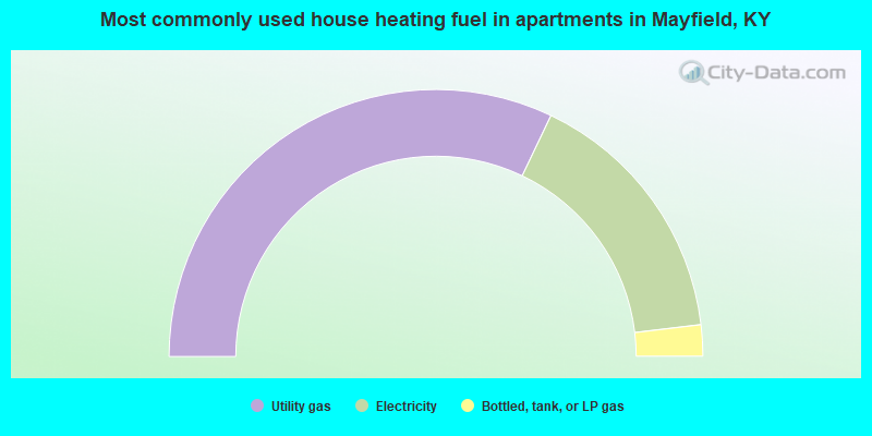
- 64.2%Utility gas
- 32.0%Electricity
- 3.8%Bottled, tank, or LP gas
Mayfield compared to Kentucky state average:
- Median house value below state average.
- Unemployed percentage below state average.
- Hispanic race population percentage significantly above state average.
- Length of stay since moving in below state average.
- Number of college students below state average.
Mayfield on our top lists:
- #22 on the list of "Top 101 cities with the most full-time firefighters per 1000 residents (population 5,000+)"
- #41 on the list of "Top 101 cities with the largest city-data.com crime index decrease from 2011 to 2012 (population 5,000+)"
- #55 on the list of "Top 101 cities with the largest household incomes disparities (population 5,000+)"
- #72 on the list of "Top 101 cities with the most people below the poverty level, excluding cities with 15% or more of residents in college and with the median age below 28 (population 5,000+)"

|
|
Total of 8 patent applications in 2008-2024.