Milford, Nebraska
Submit your own pictures of this city and show them to the world
- OSM Map
- General Map
- Google Map
- MSN Map

Population change since 2000: +6.6%
 |
| Males: 1,197 | |
| Females: 1,009 |
| Median resident age: | 31.5 years |
| Nebraska median age: | 37.4 years |
Zip codes: 68405.
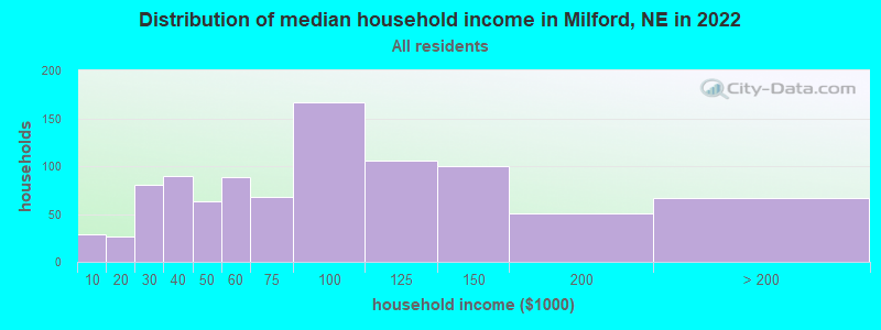
| Milford: | $75,128 |
| NE: | $69,597 |
Estimated per capita income in 2022: $35,648 (it was $16,217 in 2000)
Milford city income, earnings, and wages data
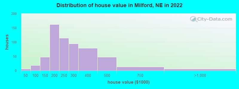
Estimated median house or condo value in 2022: $234,096 (it was $87,600 in 2000)
| Milford: | $234,096 |
| NE: | $232,400 |
Mean prices in 2022: all housing units: $259,801; detached houses: $266,853; townhouses or other attached units: $217,190; in 2-unit structures: $166,594; mobile homes: $47,907
Median gross rent in 2022: $889.
(9.5% for White Non-Hispanic residents, 100.0% for American Indian residents, 2.4% for two or more races residents)
Detailed information about poverty and poor residents in Milford, NE
Compare current foreclosures near Milford, NE:
| Photo | Address | Area | Beds / Baths | Price | Details |
|---|---|---|---|---|---|

|
#1
Park Ave
Milford, NE 68405
|
1,200 sq. feet
|
2 baths 2 beds |
show details | |

|
#2
W Washington St
Lincoln, NE 68522
|
- sq. feet
|
2 baths 2 beds |
show details | |

|
#3
NW 55th St
Lincoln, NE 68524
|
910 sq. feet
|
1 baths 3 beds |
show details | |

|
#4
SW 10th St
Lincoln, NE 68522
|
1,728 sq. feet
|
2 baths 4 beds |
show details | |

|
#5
SW 12th St
Lincoln, NE 68522
|
1,454 sq. feet
|
2 baths 3 beds |
show details | |

|
#6
SW 15th St
Lincoln, NE 68522
|
1,060 sq. feet
|
2 baths 3 beds |
show details | |

|
#7
W Apricot Ln
Lincoln, NE 68522
|
804 sq. feet
|
1 baths 2 beds |
show details | |

|
#8
W Sumner St
Lincoln, NE 68522
|
2,414 sq. feet
|
3 baths 3 beds |
show details | |

|
#9
S Main St
Friend, NE 68359
|
1,372 sq. feet
|
1 baths 2 beds |
show details | |

|
#10
Timber Ridge Cir
Lincoln, NE 68522
|
1,430 sq. feet
|
1 baths 3 beds |
show details |
| Photo | Address | Area | Beds / Baths | Price | Details |
|---|---|---|---|---|---|

|
#11
NW 50th St
Lincoln, NE 68524
|
2,790 sq. feet
|
3 baths 4 beds |
show details | |

|
#12
154th
Pleasant Dale, NE 68423
|
2,220 sq. feet
|
1 baths 4 beds |
show details | |

|
#13
W Saint Paul Ave
Lincoln, NE 68524
|
1,028 sq. feet
|
1 baths 3 beds |
show details | |

|
#14
W Partridge Ln
Lincoln, NE 68528
|
1,365 sq. feet
|
2 baths 2 beds |
show details | |

|
#15
NW 55th St
Lincoln, NE 68524
|
1,342 sq. feet
|
1 baths 3 beds |
show details | |

|
#16
NW 47th St
Lincoln, NE 68524
|
1,110 sq. feet
|
2 baths 2 beds |
show details | |

|
#17
Oak Ave
Crete, NE 68333
|
1,028 sq. feet
|
2 baths 3 beds |
show details | |

|
#18
Malcolm Rd
Malcolm, NE 68402
|
936 sq. feet
|
1 baths 3 beds |
show details | |

|
#19
NW 55th St
Lincoln, NE 68528
|
794 sq. feet
|
1 baths 2 beds |
show details | |

|
#20
Pine Ave
Crete, NE 68333
|
619 sq. feet
|
1 baths 1 beds |
show details |
| Photo | Address | Area | Beds / Baths | Price | Details |
|---|---|---|---|---|---|

|
#21
Juniper Ave
Crete, NE 68333
|
1,163 sq. feet
|
1 baths 3 beds |
show details | |

|
#22
Hawthorne Ave
Crete, NE 68333
|
1,816 sq. feet
|
2 baths 3 beds |
show details | |

|
#23
Franklin Dr
Crete, NE 68333
|
1,884 sq. feet
|
3 baths 3 beds |
show details | |

|
#24
Alvo Rd
Utica, NE 68456
|
2,989 sq. feet
|
2 baths 3 beds |
show details | |

|
#25
Elm St
Seward, NE 68434
|
1,198 sq. feet
|
2 baths - beds |
show details | |

|
#26
Rainbow Ave
Seward, NE 68434
|
- sq. feet
|
- baths - beds |
show details | |

|
#27
SW 12th St # 100
Lincoln, NE 68523
|
- sq. feet
|
- baths - beds |
show details | |

|
#28
Linden Ave Apt 5
Crete, NE 68333
|
- sq. feet
|
- baths - beds |
show details | |

|
#29
W C St Apt 208
Lincoln, NE 68522
|
- sq. feet
|
- baths - beds |
show details | |

|
#30
N 4th St
Seward, NE 68434
|
- sq. feet
|
- baths - beds |
show details |
| Photo | Address | Area | Beds / Baths | Price | Details |
|---|---|---|---|---|---|

|
#31
SW 16th St
Lincoln, NE 68522
|
- sq. feet
|
- baths - beds |
show details | |

|
#32
W Panorama Rd
Lincoln, NE 68523
|
- sq. feet
|
- baths - beds |
show details | |

|
#33
SW 27th St Apt 128
Lincoln, NE 68522
|
- sq. feet
|
- baths - beds |
show details | |

|
#34
NW 57th St
Lincoln, NE 68524
|
- sq. feet
|
- baths - beds |
show details | |

|
#35
NW 49th St
Lincoln, NE 68524
|
- sq. feet
|
- baths - beds |
show details | |

|
#36
SW Derek Ave
Lincoln, NE 68522
|
- sq. feet
|
- baths - beds |
show details | |

|
#37
NW 49th St
Lincoln, NE 68524
|
- sq. feet
|
- baths - beds |
show details | |

|
#38
W Loring St
Lincoln, NE 68524
|
- sq. feet
|
- baths - beds |
show details | |

|
#39
W Hub Hall Dr
Lincoln, NE 68528
|
- sq. feet
|
- baths - beds |
show details | |

|
#40
NW 50th St
Lincoln, NE 68524
|
- sq. feet
|
- baths - beds |
show details |
| Photo | Address | Area | Beds / Baths | Price | Details |
|---|---|---|---|---|---|

|
#41
W Craw St
Lincoln, NE 68524
|
- sq. feet
|
- baths - beds |
show details | |

|
#42
W Whisperwood St
Lincoln, NE 68528
|
- sq. feet
|
- baths - beds |
show details | |

|
#43
W Olympic Cir
Lincoln, NE 68524
|
- sq. feet
|
- baths - beds |
show details | |

|
#44
SW 50th St
Lincoln, NE 68522
|
- sq. feet
|
- baths - beds |
show details | |

|
#45
S Folsom St Apt 2
Lincoln, NE 68522
|
- sq. feet
|
- baths - beds |
show details | |

|
#46
Branched Oak Rd
Staplehurst, NE 68439
|
- sq. feet
|
- baths - beds |
show details | |

|
Check over 1 million property listings on Foreclosure.com!
|
browse all offers | |||


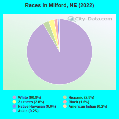
- 2,30890.8%White alone
- 732.9%Hispanic
- 722.8%Two or more races
- 411.6%Black alone
- 160.6%Native Hawaiian and Other
Pacific Islander alone - 40.2%American Indian alone
- 40.2%Asian alone
Races in Milford detailed stats: ancestries, foreign born residents, place of birth
According to our research of Nebraska and other state lists, there were 8 registered sex offenders living in Milford, Nebraska as of May 21, 2024.
The ratio of all residents to sex offenders in Milford is 303 to 1.
Type |
2009 |
2010 |
2011 |
2012 |
2013 |
2017 |
2021 |
2022 |
|---|---|---|---|---|---|---|---|---|
| Murders (per 100,000) | 0 (0.0) | 0 (0.0) | 0 (0.0) | 0 (0.0) | 0 (0.0) | 0 (0.0) | 0 (0.0) | 0 (0.0) |
| Rapes (per 100,000) | 0 (0.0) | 1 (47.8) | 2 (94.8) | 1 (47.6) | 0 (0.0) | 0 (0.0) | 1 (49.9) | 1 (46.7) |
| Robberies (per 100,000) | 0 (0.0) | 0 (0.0) | 0 (0.0) | 0 (0.0) | 0 (0.0) | 0 (0.0) | 0 (0.0) | 0 (0.0) |
| Assaults (per 100,000) | 1 (49.1) | 0 (0.0) | 1 (47.4) | 0 (0.0) | 0 (0.0) | 1 (47.3) | 1 (49.9) | 1 (46.7) |
| Burglaries (per 100,000) | 11 (540.0) | 2 (95.7) | 3 (142.2) | 8 (381.1) | 8 (367.5) | 6 (283.7) | 0 (0.0) | 5 (233.4) |
| Thefts (per 100,000) | 18 (883.7) | 19 (909.1) | 21 (995.7) | 22 (1,048) | 18 (826.8) | 17 (803.8) | 1 (49.9) | 1 (46.7) |
| Auto thefts (per 100,000) | 3 (147.3) | 0 (0.0) | 0 (0.0) | 0 (0.0) | 0 (0.0) | 0 (0.0) | 0 (0.0) | 1 (46.7) |
| Arson (per 100,000) | 0 (0.0) | 1 (47.8) | 0 (0.0) | 0 (0.0) | 1 (45.9) | 0 (0.0) | 0 (0.0) | 0 (0.0) |
| City-Data.com crime index | 94.7 | 81.3 | 135.1 | 106.7 | 58.8 | 61.5 | 51.8 | 68.6 |
The City-Data.com crime index weighs serious crimes and violent crimes more heavily. Higher means more crime, U.S. average is 246.1. It adjusts for the number of visitors and daily workers commuting into cities.
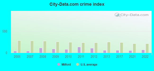
Crime rate in Milford detailed stats: murders, rapes, robberies, assaults, burglaries, thefts, arson
Full-time law enforcement employees in 2021, including police officers: 3 (3 officers - 2 male; 1 female).
| Officers per 1,000 residents here: | 1.50 |
| US average: | 2.38 |
 Recent articles from our blog. Our writers, many of them Ph.D. graduates or candidates, create easy-to-read articles on a wide variety of topics.


 | Female Scientist in 50's moving to Lincoln (4 replies) |
| looking to move to Lincoln area- request info please (8 replies) |
| What is desirable little town in NE? (11 replies) |
| Tell me about Nebraska please (64 replies) |
| Do You Get Defensive About Being From Nebraska? (97 replies) |
| In need of your assistance | California to Nowhere (9 replies) |
Latest news from Milford, NE collected exclusively by city-data.com from local newspapers, TV, and radio stations
Ancestries: German (46.8%), American (14.2%), Irish (6.1%), English (5.8%), European (4.3%), Haitian (2.5%).
Current Local Time: CST time zone
Incorporated on 04/1864
Elevation: 1450 feet
Land area: 0.71 square miles.
Population density: 3,093 people per square mile (average).
48 residents are foreign born
| This city: | 1.9% |
| Nebraska: | 7.5% |
Median real estate property taxes paid for housing units with mortgages in 2022: $2,673 (1.3%)
Median real estate property taxes paid for housing units with no mortgage in 2022: $2,917 (1.1%)
Nearest city with pop. 50,000+: Lincoln, NE  (19.9 miles , pop. 225,581).
Nearest city with pop. 1,000,000+: Chicago, IL (492.3 miles , pop. 2,896,016).
Nearest cities:
), ), ), Latitude: 40.77 N, Longitude: 97.05 W
Area code: 402
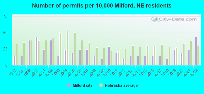
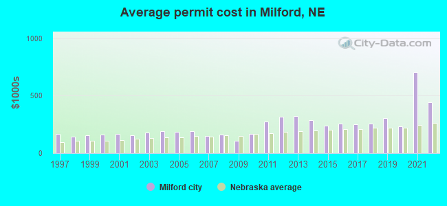
Single-family new house construction building permits:
- 2022: 9 buildings, average cost: $441,700
- 2021: 5 buildings, average cost: $706,000
- 2020: 4 buildings, average cost: $233,800
- 2019: 5 buildings, average cost: $303,300
- 2018: 2 buildings, average cost: $255,000
- 2017: 3 buildings, average cost: $251,700
- 2016: 3 buildings, average cost: $259,400
- 2015: 3 buildings, average cost: $241,700
- 2014: 3 buildings, average cost: $286,900
- 2013: 3 buildings, average cost: $324,200
- 2012: 2 buildings, average cost: $320,000
- 2011: 4 buildings, average cost: $273,800
- 2010: 6 buildings, average cost: $167,200
- 2009: 2 buildings, average cost: $106,000
- 2008: 3 buildings, average cost: $162,200
- 2007: 5 buildings, average cost: $150,300
- 2006: 5 buildings, average cost: $192,600
- 2005: 4 buildings, average cost: $187,700
- 2004: 5 buildings, average cost: $189,600
- 2003: 3 buildings, average cost: $181,800
- 2002: 8 buildings, average cost: $157,500
- 2001: 5 buildings, average cost: $167,400
- 2000: 9 buildings, average cost: $164,400
- 1999: 8 buildings, average cost: $154,000
- 1998: 3 buildings, average cost: $145,300
- 1997: 3 buildings, average cost: $169,900
| Here: | 2.1% |
| Nebraska: | 2.2% |
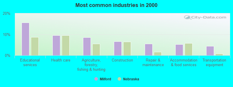
- Educational services (15.5%)
- Health care (9.5%)
- Agriculture, forestry, fishing & hunting (8.6%)
- Construction (6.6%)
- Repair & maintenance (5.6%)
- Accommodation & food services (5.2%)
- Transportation equipment (4.5%)
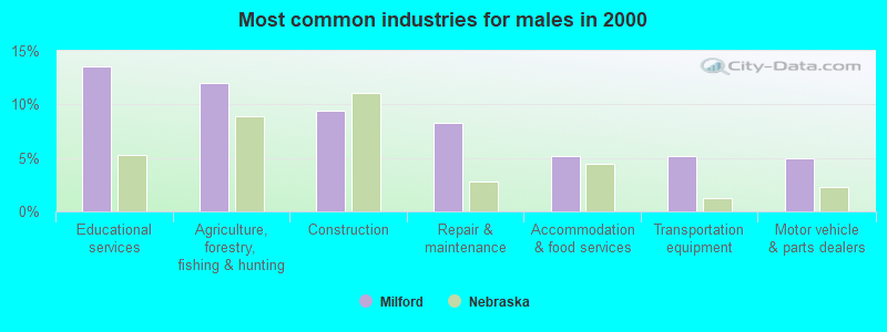
- Educational services (13.5%)
- Agriculture, forestry, fishing & hunting (12.0%)
- Construction (9.4%)
- Repair & maintenance (8.3%)
- Accommodation & food services (5.1%)
- Transportation equipment (5.1%)
- Motor vehicle & parts dealers (5.0%)
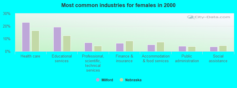
- Health care (23.0%)
- Educational services (19.3%)
- Professional, scientific, technical services (7.0%)
- Finance & insurance (6.4%)
- Accommodation & food services (5.3%)
- Public administration (4.3%)
- Social assistance (3.7%)

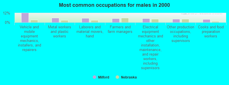
- Vehicle and mobile equipment mechanics, installers, and repairers (7.7%)
- Metal workers and plastic workers (4.4%)
- Building and grounds cleaning and maintenance occupations (4.1%)
- Farmers and farm managers (3.6%)
- Cooks and food preparation workers (3.6%)
- Laborers and material movers, hand (3.6%)
- Other production occupations, including supervisors (3.4%)
- Vehicle and mobile equipment mechanics, installers, and repairers (11.8%)
- Metal workers and plastic workers (5.8%)
- Laborers and material movers, hand (5.6%)
- Farmers and farm managers (5.3%)
- Electrical equipment mechanics and other installation, maintenance, and repair workers, including supervisors (5.3%)
- Other production occupations, including supervisors (4.3%)
- Cooks and food preparation workers (4.1%)
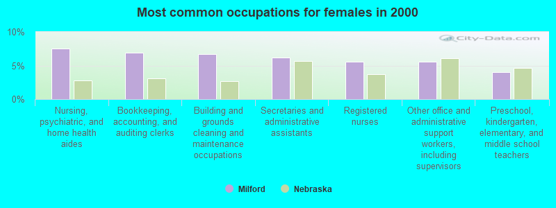
- Nursing, psychiatric, and home health aides (7.5%)
- Bookkeeping, accounting, and auditing clerks (7.0%)
- Building and grounds cleaning and maintenance occupations (6.7%)
- Secretaries and administrative assistants (6.1%)
- Registered nurses (5.6%)
- Other office and administrative support workers, including supervisors (5.6%)
- Preschool, kindergarten, elementary, and middle school teachers (4.0%)
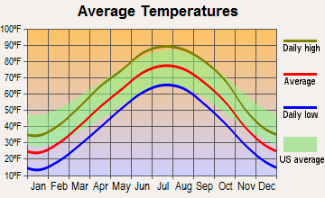
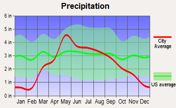
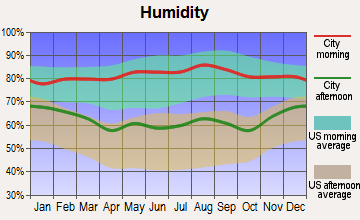
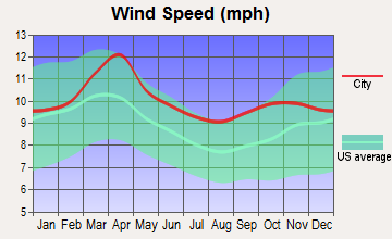
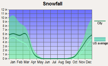
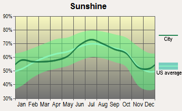
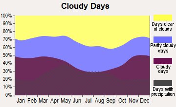
Average climate in Milford, Nebraska
Based on data reported by over 4,000 weather stations
|
|

(lower is better)
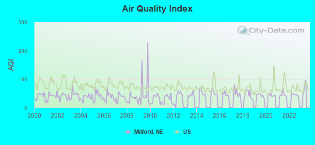
Air Quality Index (AQI) level in 2022 was 43.2. This is significantly better than average.
| City: | 43.2 |
| U.S.: | 72.6 |
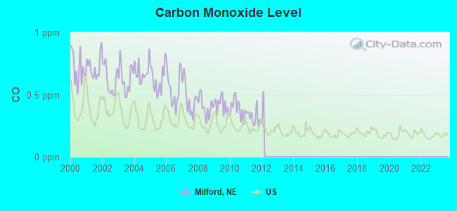
Carbon Monoxide (CO) [ppm] level in 2011 was 0.319. This is worse than average. Closest monitor was 19.1 miles away from the city center.
| City: | 0.319 |
| U.S.: | 0.251 |
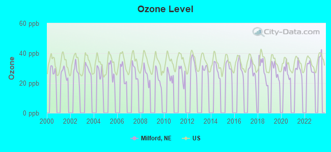
Ozone [ppb] level in 2022 was 30.1. This is about average. Closest monitor was 19.3 miles away from the city center.
| City: | 30.1 |
| U.S.: | 33.3 |
Tornado activity:
Milford-area historical tornado activity is slightly above Nebraska state average. It is 110% greater than the overall U.S. average.
On 6/13/2001, a category F4 (max. wind speeds 207-260 mph) tornado 5.6 miles away from the Milford city center injured 2 people and caused $1 million in damages.
On 5/5/1964, a category F5 (max. wind speeds 261-318 mph) tornado 41.6 miles away from the city center killed 4 people and injured 50 people and caused between $500,000 and $5,000,000 in damages.
Earthquake activity:
Milford-area historical earthquake activity is significantly above Nebraska state average. It is 384% greater than the overall U.S. average.On 9/3/2016 at 12:02:44, a magnitude 5.8 (5.8 MW, Depth: 3.5 mi, Class: Moderate, Intensity: VI - VII) earthquake occurred 300.7 miles away from the city center
On 11/6/2011 at 03:53:10, a magnitude 5.7 (5.7 MW, Depth: 3.2 mi) earthquake occurred 362.8 miles away from the city center
On 6/22/2019 at 08:50:24, a magnitude 4.6 (4.6 MW, Depth: 1.9 mi, Class: Light, Intensity: IV - V) earthquake occurred 165.5 miles away from Milford center
On 11/12/2014 at 21:40:00, a magnitude 4.9 (4.9 MW, Depth: 2.5 mi) earthquake occurred 244.1 miles away from the city center
On 1/19/2020 at 19:08:42, a magnitude 4.5 (4.5 MW, Depth: 3.1 mi) earthquake occurred 196.3 miles away from the city center
On 2/13/2016 at 17:07:06, a magnitude 5.1 (5.1 MW, Depth: 5.2 mi) earthquake occurred 309.4 miles away from the city center
Magnitude types: moment magnitude (MW)
Natural disasters:
The number of natural disasters in Seward County (15) is near the US average (15).Major Disasters (Presidential) Declared: 12
Emergencies Declared: 1
Causes of natural disasters: Floods: 10, Storms: 9, Tornadoes: 4, Winds: 4, Winter Storms: 2, Hurricane: 1, Ice Storm: 1, Snow: 1, Snowstorm: 1, Other: 1 (Note: some incidents may be assigned to more than one category).
Hospitals and medical centers in Milford:
Airports located in Milford:
- Roth Airport (NE65) (Runways: 1)
Colleges/universities with over 2000 students nearest to Milford:
- University of Nebraska-Lincoln (about 19 miles; Lincoln, NE; Full-time enrollment: 20,817)
- Nebraska Wesleyan University (about 22 miles; Lincoln, NE; FT enrollment: 2,072)
- Southeast Community College Area (about 23 miles; Lincoln, NE; FT enrollment: 8,838)
- University of Nebraska at Omaha (about 64 miles; Omaha, NE; FT enrollment: 12,073)
- Bellevue University (about 65 miles; Bellevue, NE; FT enrollment: 7,139)
- University of Nebraska Medical Center (about 66 miles; Omaha, NE; FT enrollment: 2,815)
- Creighton University (about 68 miles; Omaha, NE; FT enrollment: 5,370)
Public high school in Milford:
- MILFORD HIGH SCHOOL (Location: 301 G ST, Grades: 7-12)
Public elementary/middle school in Milford:
- MILFORD ELEMENTARY SCHOOL (Location: 1200 WEST 1ST ST, Grades: PK-6)
Points of interest:
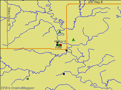
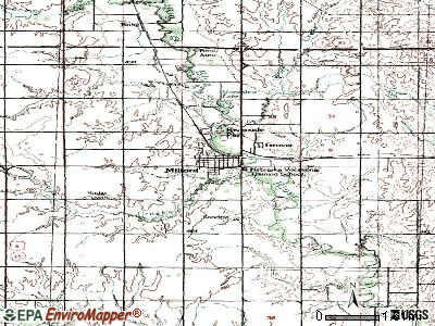
Notable locations in Milford: Westward Ho! Campground (A), Milford (B), Dorchester Farmers Cooperative Elevator (C), Countryside Co-op Elevator (D), Maintenance Building (E), Pioneer Complex (F), Nebraska Hall (G), Cornhusker Hall (H), Industry Training Center (I), Presidents Home (J), Welsh Center Gymnasium and Student Center (K), Eicher Technical Center (L), Webermeier Memorial Library (M), Milford Volunteer Fire and Rescue (N). Display/hide their locations on the map
Churches in Milford include: Missionary Church (A), United Methodist Church (B), Good Shepherd Lutheran Church (C), Assembly of God Church (D), Beth-El Mennonite Church (E). Display/hide their locations on the map
Creek: Coon Creek (A). Display/hide its location on the map
Parks in Milford include: Welch Park (1), Uptown Park (2), South Park (3). Display/hide their locations on the map
Birthplace of: Bill Rumler - Professional baseball player, Harry Culver - Soilder, Victor Mills - Centenarian.
Drinking water stations with addresses in Milford and their reported violations in the past:
MILFORD, CITY OF (Population served: 2,105, Groundwater):Past monitoring violations:
- One regular monitoring violation
| This city: | 2.4 people |
| Nebraska: | 2.5 people |
| This city: | 64.2% |
| Whole state: | 64.8% |
| This city: | 4.0% |
| Whole state: | 6.0% |
Likely homosexual households (counted as self-reported same-sex unmarried-partner households)
- Lesbian couples: 0.3% of all households
- Gay men: 0.0% of all households
38 people in nursing facilities/skilled-nursing facilities in 2010
263 people in college dormitories (includes college quarters off campus) in 2000
46 people in nursing homes in 2000
Banks with branches in Milford (2011 data):
- The Jones National Bank and Trust Company of Seward: Milford Branch at 807 Fifth Street, branch established on 2004/01/12. Info updated 2006/11/03: Bank assets: $215.5 mil, Deposits: $175.5 mil, headquarters in Seward, NE, positive income, Agricultural Specialization, 3 total offices, Holding Company: Jones National Corporation
- Farmers and Merchants Bank: Farmers And Merchants Bank at 617 First Street, branch established on 1949/07/05. Info updated 2008/02/28: Bank assets: $480.8 mil, Deposits: $339.8 mil, local headquarters, positive income, Agricultural Specialization, 11 total offices, Holding Company: Country Bank Shares, Inc.
For population 15 years and over in Milford:
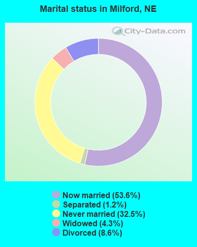
- Never married: 32.5%
- Now married: 53.6%
- Separated: 1.2%
- Widowed: 4.3%
- Divorced: 8.6%
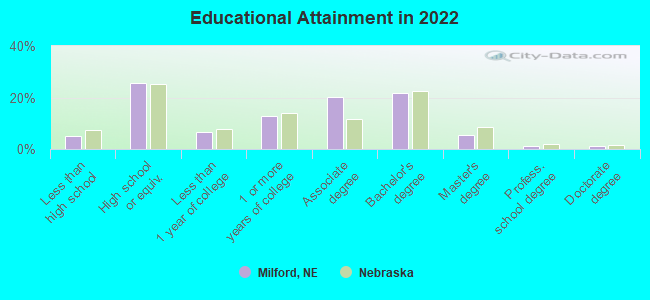
For population 25 years and over in Milford:
- High school or higher: 93.3%
- Bachelor's degree or higher: 28.2%
- Graduate or professional degree: 7.4%
- Unemployed: 2.7%
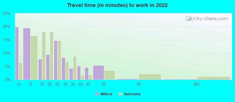
- Mean travel time to work (commute): 17.3 minutes
| Here: | 8.5 |
| Nebraska average: | 11.2 |
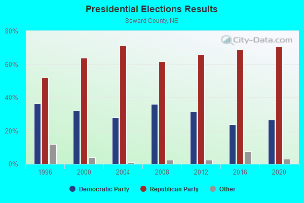
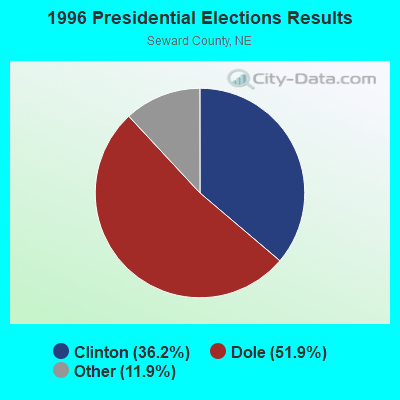
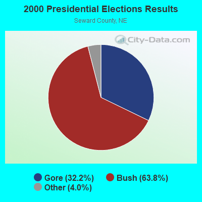
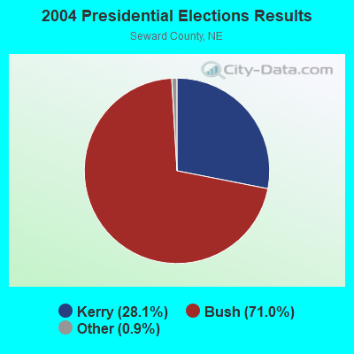
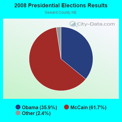

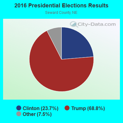
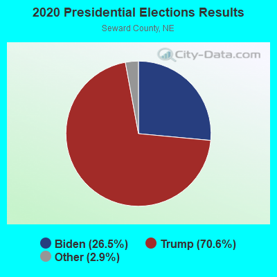
Graphs represent county-level data. Detailed 2008 Election Results
Religion statistics for Milford, NE (based on Seward County data)
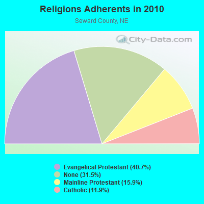
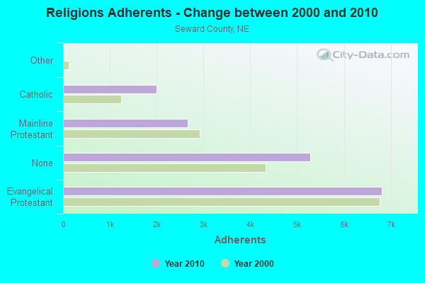
| Religion | Adherents | Congregations |
|---|---|---|
| Evangelical Protestant | 6,815 | 24 |
| Mainline Protestant | 2,664 | 12 |
| Catholic | 1,993 | 4 |
| Other | 3 | 1 |
| None | 5,275 | - |
Food Environment Statistics:
| Seward County: | 2.42 / 10,000 pop. |
| Nebraska: | 2.60 / 10,000 pop. |
| Here: | 0.61 / 10,000 pop. |
| Nebraska: | 0.44 / 10,000 pop. |
| This county: | 4.84 / 10,000 pop. |
| State: | 4.83 / 10,000 pop. |
| This county: | 6.05 / 10,000 pop. |
| Nebraska: | 7.76 / 10,000 pop. |
| Seward County: | 7.9% |
| State: | 7.9% |
| Here: | 27.1% |
| Nebraska: | 28.0% |
| Here: | 13.1% |
| Nebraska: | 12.9% |
Health and Nutrition:
| Milford: | 48.8% |
| State: | 48.9% |
| Milford: | 46.1% |
| Nebraska: | 45.5% |
| Here: | 28.2 |
| Nebraska: | 28.6 |
| Milford: | 20.6% |
| Nebraska: | 21.4% |
| Milford: | 9.5% |
| State: | 10.5% |
| Milford: | 6.9 |
| Nebraska: | 6.8 |
| Milford: | 32.3% |
| Nebraska: | 33.5% |
| This city: | 56.0% |
| Nebraska: | 55.6% |
| Milford: | 77.4% |
| State: | 78.2% |
More about Health and Nutrition of Milford, NE Residents
| Local government employment and payroll (March 2022) | |||||
| Function | Full-time employees | Monthly full-time payroll | Average yearly full-time wage | Part-time employees | Monthly part-time payroll |
|---|---|---|---|---|---|
| Police Protection - Officers | 3 | $14,271 | $57,084 | 1 | $443 |
| Financial Administration | 2 | $8,390 | $50,340 | 0 | $0 |
| Streets and Highways | 1 | $2,974 | $35,688 | 0 | $0 |
| Water Supply | 1 | $9,433 | $113,196 | 0 | $0 |
| Parks and Recreation | 1 | $3,113 | $37,356 | 0 | $0 |
| Local Libraries | 1 | $2,907 | $34,884 | 3 | $1,499 |
| Sewerage | 1 | $5,500 | $66,000 | 0 | $0 |
| Other and Unallocable | 0 | $0 | 2 | $312 | |
| Welfare | 0 | $0 | 1 | $2,602 | |
| Other Government Administration | 0 | $0 | 5 | $800 | |
| Totals for Government | 10 | $46,589 | $55,907 | 12 | $5,656 |
Milford government finances - Expenditure in 2021 (per resident):
- Construction - Water Utilities: $245,000 ($111.06)
Sewerage: $200,000 ($90.66)
Central Staff Services: $10,000 ($4.53)
Financial Administration: $8,000 ($3.63)
General Public Buildings: $2,000 ($0.91)
- Current Operations - Housing and Community Development: $1,729,000 ($783.77)
Water Utilities: $856,000 ($388.03)
Sewerage: $570,000 ($258.39)
Regular Highways: $563,000 ($255.21)
Central Staff Services: $418,000 ($189.48)
Police Protection: $353,000 ($160.02)
Financial Administration: $321,000 ($145.51)
Parks and Recreation: $229,000 ($103.81)
Local Fire Protection: $226,000 ($102.45)
Libraries: $76,000 ($34.45)
General Public Buildings: $64,000 ($29.01)
- General - Interest on Debt: $6,000 ($2.72)
- Other Capital Outlay - Parks and Recreation: $99,000 ($44.88)
Regular Highways: $35,000 ($15.87)
Police Protection: $33,000 ($14.96)
Libraries: $33,000 ($14.96)
Local Fire Protection: $21,000 ($9.52)
Financial Administration: $2,000 ($0.91)
Central Staff Services: $2,000 ($0.91)
- Total Salaries and Wages: $2,541,000 ($1151.86)
Milford government finances - Revenue in 2021 (per resident):
- Charges - Sewerage: $951,000 ($431.10)
Parks and Recreation: $50,000 ($22.67)
- Local Intergovernmental - General Local Government Support: $34,000 ($15.41)
- Miscellaneous - General Revenue - Other: $65,000 ($29.47)
Interest Earnings: $44,000 ($19.95)
- Revenue - Water Utilities: $1,284,000 ($582.05)
- State Intergovernmental - Highways: $209,000 ($94.74)
General Local Government Support: $147,000 ($66.64)
- Tax - Property: $590,000 ($267.45)
General Sales and Gross Receipts: $194,000 ($87.94)
Other License: $100,000 ($45.33)
Milford government finances - Debt in 2021 (per resident):
- Long Term Debt - Issue, Unspecified Public Purpose: $943,000 ($427.47)
Outstanding Unspecified Public Purpose: $865,000 ($392.11)
Retired Unspecified Public Purpose: $208,000 ($94.29)
Beginning Outstanding - Unspecified Public Purpose: $130,000 ($58.93)
Milford government finances - Cash and Securities in 2021 (per resident):
- Bond Funds - Cash and Securities: $45,000 ($20.40)
- Other Funds - Cash and Securities: $2,185,000 ($990.48)
Businesses in Milford, NE
- Dairy Queen: 1
- Subway: 1
Strongest AM radio stations in Milford:
- KFAB (1110 AM; 50 kW; OMAHA, NE; Owner: CAPSTAR TX LIMITED PARTNERSHIP)
- KOIL (1020 AM; 50 kW; PLATTSMOUTH, NE; Owner: WAITT RADIO, INC.)
- KKAR (1290 AM; 50 kW; OMAHA, NE; Owner: WAITT RADIO, INC.)
- KMMJ (750 AM; 10 kW; GRAND ISLAND, NE; Owner: JRK BROADCASTING, L.L.C.)
- KYDZ (1180 AM; 25 kW; BELLEVUE, NE; Owner: WAITT RADIO, INC.)
- KRVN (880 AM; 50 kW; LEXINGTON, NE; Owner: NEBRASKA RURAL RADIO ASSOCIATION)
- WHB (810 AM; 50 kW; KANSAS CITY, MO; Owner: UNION BROADCASTING, INC.)
- KFOR (1240 AM; 1 kW; LINCOLN, NE; Owner: THREE EAGLES OF LINCOLN, INC.)
- KOMJ (590 AM; 5 kW; OMAHA, NE; Owner: JOURNAL BROADCAST CORPORATION)
- KLIN (1400 AM; 1 kW; LINCOLN, NE; Owner: MONTEREY LICENSES, LLC)
- KOZN (1620 AM; 10 kW; BELLEVUE, NE; Owner: WAITT RADIO, INC.)
- KLNG (1560 AM; daytime; 10 kW; COUNCIL BLUFFS, IA)
- WHO (1040 AM; 50 kW; DES MOINES, IA; Owner: CITICASTERS LICENSES, L.P.)
Strongest FM radio stations in Milford:
- KTGL (92.9 FM; BEATRICE, NE; Owner: CAPSTAR TX LIMITED PARTNERSHIP)
- KUCV (91.1 FM; LINCOLN, NE; Owner: NEBRASKA EDUCATIONAL TELECOMMUNICATIONS COMM.)
- KIBZ (106.3 FM; LINCOLN, NE; Owner: CAPSTAR TX LIMITED PARTNERSHIP)
- KTMX (104.9 FM; YORK, NE; Owner: PRAIRIE STATES BROADCASTING, INC.)
- KFRX (102.7 FM; LINCOLN, NE; Owner: THREE EAGLES OF LINCOLN, INC.)
- KSLI-FM (104.1 FM; CRETE, NE; Owner: CAPSTAR TX LIMITED PARTNERSHIP)
- KBBK (107.3 FM; LINCOLN, NE; Owner: MONTEREY LICENSES, LLC)
- KEFM (96.1 FM; OMAHA, NE; Owner: WEBSTER COMMUNICATIONS CO.)
- KZKX (96.9 FM; SEWARD, NE; Owner: CAPSTAR TX LIMITED PARTNERSHIP)
- KLTQ (101.9 FM; LINCOLN, NE; Owner: WAITT RADIO, INC.)
- KFLV (89.9 FM; WILBER, NE; Owner: EDUCATIONAL MEDIA FOUNDATION)
- K220GT (91.9 FM; LINCOLN, NE; Owner: EDUCATIONAL MEDIA FOUNDATION)
- KRKR (95.1 FM; LINCOLN, NE; Owner: THREE EAGLES OF LINCOLN, INC.)
- KKUL (105.3 FM; LINCOLN, NE; Owner: MONTEREY LICENSES, LLC)
TV broadcast stations around Milford:
- KOLN (Channel 10; LINCOLN, NE; Owner: KOLN/KGIN LICENSE, INC.)
- KLKN (Channel 8; LINCOLN, NE; Owner: CITADEL COMMUNICATIONS, L.L.C.)
- KUON-TV (Channel 12; LINCOLN, NE; Owner: THE UNIVERSITY OF NEBRASKA)
- K21ES (Channel 21; COLUMBUS, ETC, NE; Owner: DAVID C. BRODAHL)
- KPTM (Channel 42; OMAHA, NE; Owner: PAPPAS TELECASTING OF THE MIDLANDS)
- KXVO (Channel 15; OMAHA, NE; Owner: MITTS TELECASTING COMPANY)
- K54EU (Channel 54; COLUMBUS-FREMONT, NE; Owner: GLENDA R. HARDERS)
- K18CD (Channel 18; LINCOLN, NE; Owner: COLINS BROADCASTING COMPANY)
- K27GX (Channel 27; LINCOLN, NE; Owner: THREE ANGELS BROADCASTING NETWORK)
- KWAZ-LP (Channel 22; LINCOLN, NE; Owner: COLINS BROADCASTING COMPANY)
- K58GD (Channel 58; LINCOLN, NE; Owner: TRINITY BROADCASTING NETWORK)
- K67CV (Channel 67; LINCOLN, NE; Owner: CHANNEL AMERICA LPTV LIC. SUBSIDIARY)
Milford fatal accident list:
Oct 23, 1980 01:42 PM, Vehicles: 2, Persons: 3, Fatalities: 1
- National Bridge Inventory (NBI) Statistics
- 31Number of bridges
- 364ft / 111mTotal length
- 293,500Total average daily traffic
- 77,351Total average daily truck traffic
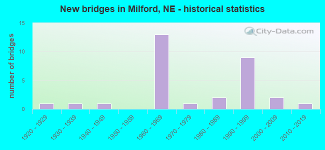
- New bridges - historical statistics
- 11920-1929
- 11930-1939
- 11940-1949
- 131960-1969
- 11970-1979
- 21980-1989
- 91990-1999
- 22000-2009
- 12010-2019
FCC Registered Antenna Towers:
42 (See the full list of FCC Registered Antenna Towers in Milford)FCC Registered Broadcast Land Mobile Towers:
6- Lat: 40.769722 Lon: -97.051694, Call Sign: KNED310,
Assigned Frequencies: 39.7800 MHz, 465.237 MHz, 465.237 MHz, Grant Date: 01/13/2015, Expiration Date: 01/17/2025, Registrant: First Wireless, Inc., 3511 North 40th Street, Lincoln, NE 68504, Phone: (402) 466-8188, Fax: (402) 466-8237, Email:
- 600 State Street (Lat: 40.768056 Lon: -97.039194), Call Sign: WPKM468,
Assigned Frequencies: 467.850 MHz, 467.875 MHz, Grant Date: 02/19/2013, Expiration Date: 01/21/2023, Cancellation Date: 03/25/2023, Certifier: Gary W Cooper, Registrant: Business Radio Licensing, 30251 Golden Lantern, Suite E # 501, Laguna Niguel, CA 92677, Phone: (949) 348-8510, Fax: (949) 348-8514, Email:
- MP24.4 WIU, Bnsf Ls4 Mp24.4, Wiu (Lat: 40.836389 Lon: -97.078000), Type: Mtower, Structure height: 4.9 m, Overall height: 7.3 m, Call Sign: WPLQ762,
Assigned Frequencies: 160.965 MHz, Grant Date: 11/17/2022, Expiration Date: 12/02/2032, Certifier: Robert C Leedham, Registrant: Bnsf Railway Co., 4515 Kansas Avenue, Kansas City, KS 66106, Phone: (913) 551-4015, Email:
- 509 First St (Lat: 40.773611 Lon: -97.047250), Call Sign: KYX795, Licensee ID: L00003451,
Assigned Frequencies: 47.9600 MHz, 48.1800 MHz, Grant Date: 08/24/2002, Expiration Date: 08/26/2012, Cancellation Date: 11/08/2005, Registrant: Nebraska Public Power District, York, NE 68467, Phone: (402) 564-8561
- South Seward Tower, 6.18 Mi W (Lat: 40.756111 Lon: -97.159444), Type: Tower, Structure height: 91.4 m, Overall height: 93.3 m, Call Sign: WQCB483, Licensee ID: L00003451,
Assigned Frequencies: 47.9600 MHz, 48.1800 MHz, Grant Date: 01/24/2005, Expiration Date: 01/24/2015, Cancellation Date: 09/23/2011, Certifier: David W Webb, Registrant: Nebraska Public Power District, 1215 West Highway 34, York, NE 68467, Phone: (402) 362-6681
- Lat: 40.833000 Lon: -97.082167, Call Sign: WRCG458,
Assigned Frequencies: 452.287 MHz, Grant Date: 09/25/2018, Expiration Date: 09/25/2028, Certifier: Matt Steuk, Registrant: Shaffer Communications, Inc., 2333 North 33rd St., Lincoln, NE 68504, Phone: (402) 466-1515, Fax: (402) 466-1540, Email:
FCC Registered Microwave Towers:
23 (See the full list of FCC Registered Microwave Towers in this town)FCC Registered Paging Towers:
2 (See the full list of FCC Registered Paging Towers)FCC Registered Amateur Radio Licenses:
14 (See the full list of FCC Registered Amateur Radio Licenses in Milford)FAA Registered Aircraft:
18 (See the full list of FAA Registered Aircraft in Milford)2002 - 2017 National Fire Incident Reporting System (NFIRS) incidents
- Fire incident types reported to NFIRS in Milford, NE
- 3735.9%Outside Fires
- 2625.2%Structure Fires
- 2221.4%Mobile Property/Vehicle Fires
- 1817.5%Other
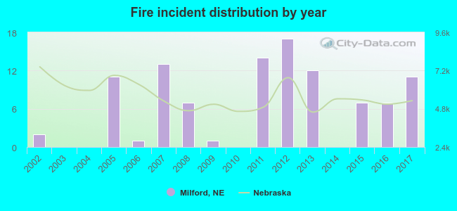 According to the data from the years 2002 - 2017 the average number of fire incidents per year is 6. The highest number of fire incidents - 17 took place in 2012, and the least - 0 in 2003. The data has an increasing trend.
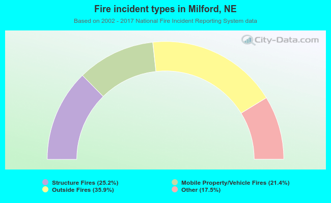 When looking into fire subcategories, the most reports belonged to: Outside Fires (35.9%), and Structure Fires (25.2%).
| Most common first names in Milford, NE among deceased individuals | ||
| Name | Count | Lived (average) |
|---|---|---|
| John | 27 | 79.0 years |
| William | 20 | 77.1 years |
| Mary | 17 | 85.1 years |
| Edward | 12 | 78.6 years |
| Anna | 12 | 89.4 years |
| Charles | 11 | 75.4 years |
| Robert | 11 | 75.8 years |
| Fred | 11 | 84.9 years |
| Clarence | 10 | 75.4 years |
| Esther | 10 | 89.7 years |
| Most common last names in Milford, NE among deceased individuals | ||
| Last name | Count | Lived (average) |
|---|---|---|
| Roth | 41 | 76.4 years |
| Stutzman | 25 | 76.6 years |
| Stauffer | 23 | 80.3 years |
| Schweitzer | 20 | 77.7 years |
| Rediger | 15 | 83.1 years |
| Burkey | 15 | 80.7 years |
| Miller | 13 | 79.4 years |
| Kremer | 12 | 84.7 years |
| Hershberger | 9 | 80.1 years |
| Ficke | 8 | 85.0 years |
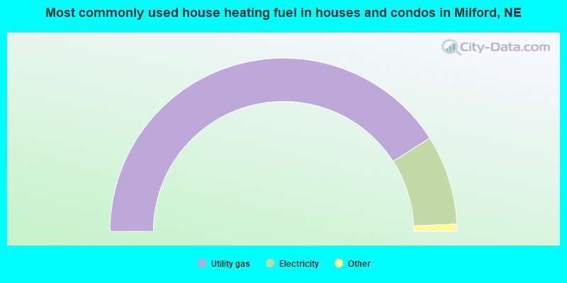
- 82.0%Utility gas
- 16.8%Electricity
- 0.7%Wood
- 0.5%Bottled, tank, or LP gas
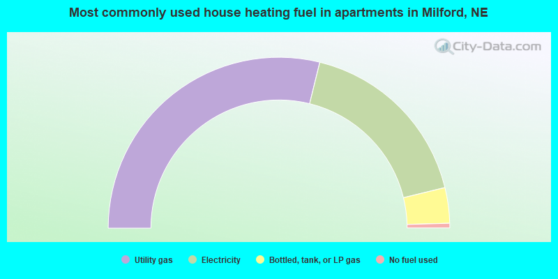
- 57.7%Utility gas
- 34.7%Electricity
- 6.7%Bottled, tank, or LP gas
- 0.9%No fuel used
Milford compared to Nebraska state average:
- Unemployed percentage significantly below state average.
- Black race population percentage below state average.
- Hispanic race population percentage significantly below state average.
- Median age significantly below state average.
- Foreign-born population percentage significantly below state average.
- Number of college students above state average.

|
Total of 5 patent applications in 2008-2024.