Millville, Iowa
Submit your own pictures of this city and show them to the world
- OSM Map
- General Map
- Google Map
- MSN Map

Population change since 2000: +26.1%
| Males: 15 | |
| Females: 14 |
| Median resident age: | 66.5 years |
| Iowa median age: | 38.9 years |
Zip code: 52035
| Millville: | $51,753 |
| IA: | $69,588 |
Estimated per capita income in 2022: $29,955 (it was $14,378 in 2000)
Estimated median house or condo value in 2022: $127,847 (it was $56,900 in 2000)
| Millville: | $127,847 |
| IA: | $194,600 |
Mean prices in 2022: all housing units: $95,037; detached houses: $94,552
Compare current foreclosures near Millville, IA:
| Photo | Address | Area | Beds / Baths | Price | Details |
|---|---|---|---|---|---|

|
#1
2nd Ave SW
Dyersville, IA 52040
|
1,276 sq. feet
|
2 baths 2 beds |
show details | |

|
#2
Hilton Ridge Way
Edgewood, IA 52042
|
1,456 sq. feet
|
- baths 3 beds |
show details | |

|
#3
Littleport Rd
Edgewood, IA 52042
|
1,610 sq. feet
|
- baths 3 beds |
show details | |

|
#4
W Front St
Cassville, WI 53806
|
- sq. feet
|
- baths - beds |
show details | |

|
#5
N 4th Ln
Guttenberg, IA 52052
|
- sq. feet
|
- baths - beds |
show details | |

|
#6
Steiger Ln
Potosi, WI 53820
|
- sq. feet
|
- baths - beds |
show details | |

|
#7
Mill St
Bloomington, WI 53804
|
- sq. feet
|
- baths - beds |
show details | |

|
#8
Dry Hollow Rd
Bagley, WI 53801
|
- sq. feet
|
- baths - beds |
show details | |

|
Check over 1 million property listings on Foreclosure.com!
|
browse all offers | |||
 Recent articles from our blog. Our writers, many of them Ph.D. graduates or candidates, create easy-to-read articles on a wide variety of topics.

 | Most scenic places in Iowa (26 replies) |
Latest news from Millville, IA collected exclusively by city-data.com from local newspapers, TV, and radio stations
Ancestries: German (53.8%), American (30.8%), English (15.4%).
Current Local Time: CST time zone
Incorporated on 04/27/1967
Elevation: 628 feet
Land area: 0.07 square miles.
Population density: 432 people per square mile (low).

Median real estate property taxes paid for housing units with mortgages in 2022: $1,850 (1.9%)
Median real estate property taxes paid for housing units with no mortgage in 2022: $938 (1.2%)
Nearest city with pop. 50,000+: Dubuque, IA  (24.2 miles , pop. 57,686).
Nearest city with pop. 200,000+: Madison, WI (89.0 miles , pop. 208,054).
Nearest city with pop. 1,000,000+: Chicago, IL (183.8 miles , pop. 2,896,016).
Nearest cities:
), )Latitude: 42.70 N, Longitude: 91.08 W


| Here: | 4.2% |
| Iowa: | 2.7% |
Average climate in Millville, Iowa
Based on data reported by over 4,000 weather stations


(lower is better)

Air Quality Index (AQI) level in 2022 was 65.2. This is about average.
| City: | 65.2 |
| U.S.: | 72.6 |

Particulate Matter (PM2.5) [µg/m3] level in 2022 was 8.17. This is about average. Closest monitor was 19.2 miles away from the city center.
| City: | 8.17 |
| U.S.: | 8.11 |
Tornado activity:
Millville-area historical tornado activity is near Iowa state average. It is 73% greater than the overall U.S. average.
On 3/13/1990, a category F4 (max. wind speeds 207-260 mph) tornado 21.2 miles away from the Millville city center caused between $5,000,000 and $50,000,000 in damages.
On 5/15/1968, a category F5 (max. wind speeds 261-318 mph) tornado 40.6 miles away from the city center killed 5 people and injured 156 people and caused between $5,000,000 and $50,000,000 in damages.
Earthquake activity:
Millville-area historical earthquake activity is significantly above Iowa state average. It is 88% greater than the overall U.S. average.On 4/18/2008 at 09:36:59, a magnitude 5.4 (5.1 MB, 4.8 MS, 5.4 MW, 5.2 MW, Class: Moderate, Intensity: VI - VII) earthquake occurred 338.4 miles away from the city center
On 6/28/2004 at 06:10:52, a magnitude 4.2 (4.2 MW, Depth: 6.2 mi, Class: Light, Intensity: IV - V) earthquake occurred 141.0 miles away from the city center
On 6/10/1987 at 23:48:54, a magnitude 5.1 (4.9 MB, 4.4 MS, 4.6 MS, 5.1 LG) earthquake occurred 316.3 miles away from Millville center
On 4/18/2008 at 09:36:59, a magnitude 5.2 (5.2 MW, Depth: 8.9 mi) earthquake occurred 338.5 miles away from Millville center
On 2/10/2010 at 09:59:35, a magnitude 3.8 (3.8 MW, Depth: 6.2 mi, Class: Light, Intensity: II - III) earthquake occurred 141.3 miles away from the city center
On 6/18/2002 at 17:37:15, a magnitude 5.0 (4.3 MB, 4.6 MW, 5.0 LG) earthquake occurred 369.6 miles away from the city center
Magnitude types: regional Lg-wave magnitude (LG), body-wave magnitude (MB), surface-wave magnitude (MS), moment magnitude (MW)
Natural disasters:
The number of natural disasters in Clayton County (26) is a lot greater than the US average (15).Major Disasters (Presidential) Declared: 23
Emergencies Declared: 1
Causes of natural disasters: Floods: 24, Storms: 20, Tornadoes: 10, Winds: 4, Heavy Rain: 1, Hurricane: 1, Other: 1 (Note: some incidents may be assigned to more than one category).

Colleges/universities with over 2000 students nearest to Millville:
- University of Wisconsin-Platteville (about 30 miles; Platteville, WI; Full-time enrollment: 7,679)
- Upper Iowa University (about 38 miles; Fayette, IA; FT enrollment: 5,275)
- Northeast Iowa Community College-Calmar (about 52 miles; Calmar, IA; FT enrollment: 3,365)
- Luther College (about 56 miles; Decorah, IA; FT enrollment: 2,700)
- Kirkwood Community College (about 63 miles; Cedar Rapids, IA; FT enrollment: 11,503)
- Hawkeye Community College (about 67 miles; Waterloo, IA; FT enrollment: 7,160)
- University of Northern Iowa (about 72 miles; Cedar Falls, IA; FT enrollment: 10,816)
Points of interest:
| This city: | 2.5 people |
| Iowa: | 2.4 people |
| This city: | 75.0% |
| Whole state: | 64.7% |
| This city: | 16.7% |
| Whole state: | 6.7% |
No gay or lesbian households reported
For population 15 years and over in Millville:

- Never married: 0.0%
- Now married: 89.3%
- Separated: 0.0%
- Widowed: 0.0%
- Divorced: 10.7%
For population 25 years and over in Millville:
- High school or higher: 85.0%
- Bachelor's degree or higher: 0.0%
- Graduate or professional degree: 0.0%
- Unemployed: 10.0%
- Mean travel time to work (commute): 45.5 minutes


| Here: | 4.3 |
| Iowa average: | 10.5 |
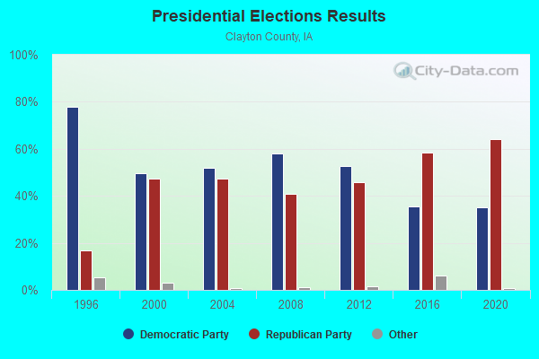
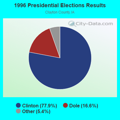


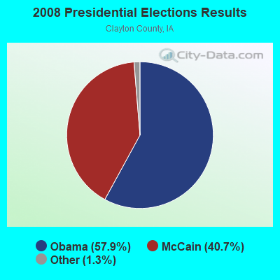
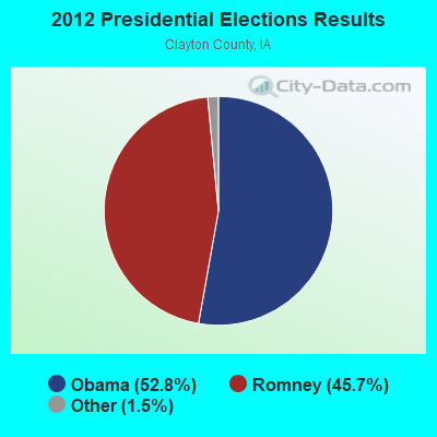


Graphs represent county-level data. Detailed 2008 Election Results
Religion statistics for Millville, IA (based on Clayton County data)
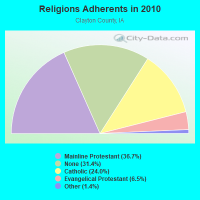
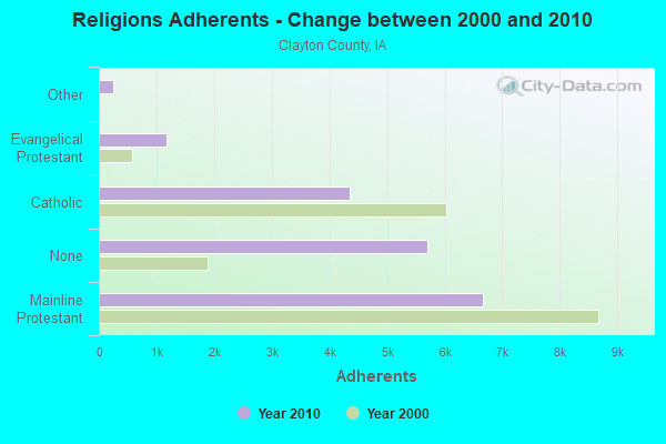
| Religion | Adherents | Congregations |
|---|---|---|
| Mainline Protestant | 6,656 | 24 |
| Catholic | 4,351 | 8 |
| Evangelical Protestant | 1,174 | 15 |
| Other | 250 | 3 |
| None | 5,698 | - |
Food Environment Statistics:
| This county: | 3.40 / 10,000 pop. |
| State: | 2.14 / 10,000 pop. |
| This county: | 7.36 / 10,000 pop. |
| Iowa: | 5.55 / 10,000 pop. |
| Clayton County: | 13.01 / 10,000 pop. |
| Iowa: | 8.01 / 10,000 pop. |
| This county: | 8.3% |
| State: | 7.8% |
| This county: | 28.4% |
| Iowa: | 27.3% |
| This county: | 15.5% |
| State: | 14.5% |
| Local government employment and payroll (March 2012) | |||||
| Function | Full-time employees | Monthly full-time payroll | Average yearly full-time wage | Part-time employees | Monthly part-time payroll |
|---|---|---|---|---|---|
| Other Government Administration | 0 | $0 | 1 | $102 | |
| Totals for Government | 0 | $0 | 1 | $102 | |
Millville government finances - Expenditure in 2012 (per resident):
- Current Operations - Solid Waste Management: $2,000 ($68.97)
General - Other: $1,000 ($34.48)
Local Fire Protection: $1,000 ($34.48)
Financial Administration: $1,000 ($34.48)
Regular Highways: $1,000 ($34.48)
- Total Salaries and Wages: $1,000 ($34.48)
Millville government finances - Revenue in 2012 (per resident):
- State Intergovernmental - Highways: $2,000 ($68.97)
- Tax - Property: $4,000 ($137.93)
General Sales and Gross Receipts: $2,000 ($68.97)
Millville government finances - Cash and Securities in 2012 (per resident):
- Other Funds - Cash and Securities: $20,000 ($689.66)
Strongest AM radio stations in Millville:
- KXEL (1540 AM; 50 kW; WATERLOO, IA; Owner: KXEL BROADCASTING COMPANY, INC.)
- KDTH (1370 AM; 5 kW; DUBUQUE, IA; Owner: RADIO DUBUQUE, INC.)
- WTMJ (620 AM; 50 kW; MILWAUKEE, WI; Owner: JOURNAL BROADCAST CORPORATION)
- WMT (600 AM; 5 kW; CEDAR RAPIDS, IA; Owner: CITICASTERS LICENSES, L.P.)
- KKHQ (950 AM; 5 kW; OELWEIN, IA; Owner: CUMULUS LICENSING CORP.)
- WSCR (670 AM; 50 kW; CHICAGO, IL; Owner: INFINITY BROADCASTING OPERATIONS, INC.)
- WHO (1040 AM; 50 kW; DES MOINES, IA; Owner: CITICASTERS LICENSES, L.P.)
- WGN (720 AM; 50 kW; CHICAGO, IL; Owner: WGN CONTINENTAL BROADCASTING CO.)
- WBBM (780 AM; 50 kW; CHICAGO, IL; Owner: INFINITY BROADCASTING OPERATIONS, INC.)
- WSPT (1010 AM; 50 kW; STEVENS POINT, WI)
- WISN (1130 AM; 50 kW; MILWAUKEE, WI; Owner: CAPSTAR TX LIMITED PARTNERSHIP)
- KADR (1400 AM; 1 kW; ELKADER, IA; Owner: DESIGN HOMES, INC.)
- WMVP (1000 AM; 50 kW; CHICAGO, IL; Owner: ABC, INC.)
Strongest FM radio stations in Millville:
- KOEL-FM (92.3 FM; OELWEIN, IA; Owner: CUMULUS LICENSING CORP.)
- KATF (92.9 FM; DUBUQUE, IA; Owner: RADIO DUBUQUE, INC.)
- KFMW (107.9 FM; WATERLOO, IA; Owner: KXEL BROADCASTING COMPANY, INC.)
- KUNI (90.9 FM; CEDAR FALLS, IA; Owner: UNIVERSITY OF NORTHERN IOWA)
- WGLR-FM (97.7 FM; LANCASTER, WI; Owner: QUEENB RADIO WISCONSIN, INC.)
- WQPC (94.3 FM; PRAIRIE DU CHIEN, WI; Owner: ROBINSON CORPORATION)
- KCTN (100.1 FM; GARNAVILLO, IA; Owner: DESIGN HOMES, INC.)
- KGRR (97.3 FM; EPWORTH, IA; Owner: RADIO DUBUQUE, INC.)
- KIYX (106.1 FM; SAGEVILLE, IA; Owner: QUEENB RADIO WISCONSIN, INC.)
- WJOD (103.3 FM; ASBURY, IA; Owner: CUMULUS LICENSING CORP.)
- WPVL-FM (107.1 FM; PLATTEVILLE, WI; Owner: QUEENB RADIO WISCONSIN, INC.)
- WVRE (101.1 FM; DICKEYVILLE, WI; Owner: RADIO DUBUQUE, INC.)
- KDST (99.3 FM; DYERSVILLE, IA; Owner: DESIGN HOMES, INC.)
- K254AE (98.7 FM; DUBUQUE, IA; Owner: UNIVERSITY OF NORTHERN IOWA)
- KXGE (102.3 FM; DUBUQUE, IA; Owner: CUMULUS LICENSING CORP.)
- K239AB (95.7 FM; DUBUQUE, IA; Owner: AUGUSTANA COLLEGE)
- KLYV (105.3 FM; DUBUQUE, IA; Owner: CUMULUS LICENSING CORP.)
- KMCH (94.7 FM; MANCHESTER, IA; Owner: FIFE COMMUNICATION COMPANY, L.C.)
- K292DJ (106.3 FM; GUTTENBURG, IA; Owner: DESIGN HOMES, INC.)
TV broadcast stations around Millville:
- KWWL (Channel 7; WATERLOO, IA; Owner: RAYCOM AMERICA, INC.)
- KGAN (Channel 2; CEDAR RAPIDS, IA; Owner: KGAN LICENSEE, LLC)
- KCRG-TV (Channel 9; CEDAR RAPIDS, IA; Owner: CEDAR RAPIDS TELEVISION CO.)
- W22CI (Channel 22; BLOOMINGTON, WI; Owner: STATE OF WISCONSIN - EDUCATIONAL COMMUNICATIONS BOARD)
- KRIN (Channel 32; WATERLOO, IA; Owner: IOWA PUBLIC BROADCASTING BOARD)
- KFXB (Channel 40; DUBUQUE, IA; Owner: DUBUQUE TV LTD. PARTNERSHIP)
- KFXA (Channel 28; CEDAR RAPIDS, IA; Owner: SECOND GENERATION OF IOWA, LTD.)
Millville fatal accident list:
Sep 26, 2013 11:54 PM, Us-52, Millville Rd, Lat: 42.705689, Lon: -91.075869, Vehicles: 2, Persons: 2, Fatalities: 1, Drunk persons involved: 1

- 54.5%Bottled, tank, or LP gas
- 27.3%Wood
- 18.2%Fuel oil, kerosene, etc.
Millville compared to Iowa state average:
- Median house value significantly below state average.
- Black race population percentage significantly below state average.
- Hispanic race population percentage significantly below state average.
- Median age below state average.
- Foreign-born population percentage significantly below state average.
- Renting percentage below state average.
- Length of stay since moving in significantly above state average.
- House age above state average.
- Percentage of population with a bachelor's degree or higher significantly below state average.