Mineral Springs, Alabama
Submit your own pictures of this place and show them to the world
- OSM Map
- General Map
- Google Map
- MSN Map

| Males: 1,745 | |
| Females: 1,622 |
| Median resident age: | 36.6 years |
| Alabama median age: | 35.8 years |
Zip code: 35046
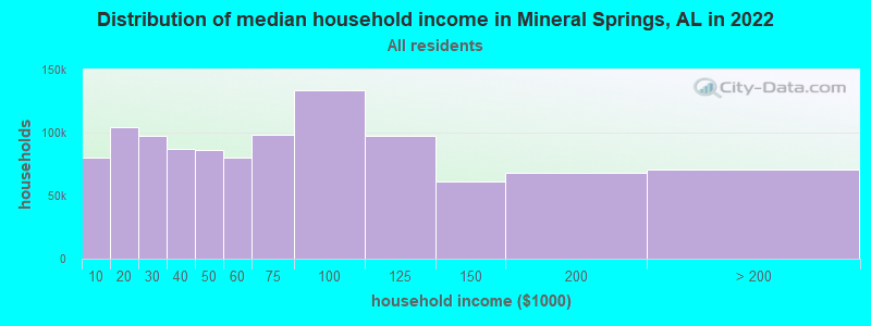
| Mineral Springs: | $69,275 |
| AL: | $59,674 |
Estimated per capita income in 2022: $31,538 (it was $16,719 in 2000)
Mineral Springs CCD income, earnings, and wages data
Estimated median house or condo value in 2022: $170,877 (it was $79,100 in 2000)
| Mineral Springs: | $170,877 |
| AL: | $200,900 |
Mean prices in 2022: all housing units: $175,098; detached houses: $222,223; townhouses or other attached units: $101,663; mobile homes: $70,238; occupied boats, rvs, vans, etc.: $51,874
Mineral Springs, AL residents, houses, and apartments details
Detailed information about poverty and poor residents in Mineral Springs, AL
Compare current foreclosures near Mineral Springs, AL:
| Photo | Address | Area | Beds / Baths | Price | Details |
|---|---|---|---|---|---|

|
#1
County Road 87
Maplesville, AL 36750
|
- sq. feet
|
2 baths 4 beds |
$210,000
|
show details |

|
#2
Main St
Jemison, AL 35085
|
1,996 sq. feet
|
2 baths 3 beds |
show details | |

|
#3
Aronimink Dr
Calera, AL 35040
|
2,511 sq. feet
|
3 baths 5 beds |
show details | |

|
#4
County Road 197
Clanton, AL 35046
|
1,960 sq. feet
|
2 baths 3 beds |
show details | |

|
#5
7th Ave
Calera, AL 35040
|
1,618 sq. feet
|
2 baths 3 beds |
show details | |

|
#6
21st Ave
Calera, AL 35040
|
1,053 sq. feet
|
1 baths 2 beds |
show details | |

|
#7
County Road 15
Maplesville, AL 36750
|
2,919 sq. feet
|
4 baths 4 beds |
show details | |

|
#8
County Road 786
Jemison, AL 35085
|
1,899 sq. feet
|
3 baths 4 beds |
show details | |

|
#9
Lake Dr
Jemison, AL 35085
|
1,962 sq. feet
|
2 baths 3 beds |
show details | |

|
#10
Waterstone Drive
Montevallo, AL 35115
|
2,305 sq. feet
|
3 baths - beds |
show details |
| Photo | Address | Area | Beds / Baths | Price | Details |
|---|---|---|---|---|---|

|
#11
County Road 51
Clanton, AL 35046
|
1,072 sq. feet
|
1 baths - beds |
show details | |

|
#12
County Road 423
Clanton, AL 35045
|
- sq. feet
|
- baths - beds |
show details | |

|
#13
Highway 25
Calera, AL 35040
|
- sq. feet
|
- baths - beds |
show details | |

|
#14
Windsong Ln
Columbiana, AL 35051
|
- sq. feet
|
- baths - beds |
show details | |

|
#15
County Road 492
Verbena, AL 36091
|
- sq. feet
|
- baths - beds |
show details | |

|
#16
County Road 727
Montevallo, AL 35115
|
825 sq. feet
|
- baths - beds |
show details | |

|
#17
County Road 97
Verbena, AL 36091
|
1,902 sq. feet
|
- baths - beds |
show details | |

|
#18
Coosa County Road 15
Rockford, AL 35136
|
- sq. feet
|
- baths - beds |
show details | |

|
#19
County Road 9
Clanton, AL 35045
|
- sq. feet
|
- baths - beds |
show details | |

|
#20
County Road 1012
Montevallo, AL 35115
|
- sq. feet
|
- baths - beds |
show details |
| Photo | Address | Area | Beds / Baths | Price | Details |
|---|---|---|---|---|---|

|
#21
County Road 1012
Montevallo, AL 35115
|
- sq. feet
|
- baths - beds |
show details | |

|
#22
County Road 76
Clanton, AL 35045
|
1,144 sq. feet
|
- baths - beds |
show details | |

|
#23
County Road 430
Clanton, AL 35045
|
- sq. feet
|
- baths - beds |
show details | |

|
#24
County Road 61
Clanton, AL 35046
|
- sq. feet
|
- baths - beds |
show details | |

|
#25
County Road 97
Verbena, AL 36091
|
- sq. feet
|
- baths - beds |
show details | |

|
#26
County Road 42
Jemison, AL 35085
|
- sq. feet
|
- baths - beds |
show details | |

|
#27
Addison Dr
Calera, AL 35040
|
- sq. feet
|
- baths - beds |
show details | |

|
#28
Bellview Ln
Sylacauga, AL 35151
|
- sq. feet
|
- baths - beds |
show details | |

|
#29
Addison Dr
Calera, AL 35040
|
- sq. feet
|
- baths - beds |
show details | |

|
#30
Oakwell St
Calera, AL 35040
|
- sq. feet
|
- baths - beds |
show details |
| Photo | Address | Area | Beds / Baths | Price | Details |
|---|---|---|---|---|---|

|
#31
Dusty Hollow Rd
Columbiana, AL 35051
|
- sq. feet
|
- baths - beds |
show details | |

|
#32
Addison Dr
Calera, AL 35040
|
- sq. feet
|
- baths - beds |
show details | |

|
#33
Kerry Cir
Calera, AL 35040
|
- sq. feet
|
- baths - beds |
show details | |

|
#34
Briarwood Apartments # 7
Columbiana, AL 35051
|
- sq. feet
|
- baths - beds |
show details | |

|
#35
Nelson Walker Rd
Columbiana, AL 35051
|
- sq. feet
|
- baths - beds |
show details | |

|
#36
County Road 866
Montevallo, AL 35115
|
- sq. feet
|
- baths - beds |
show details | |

|
#37
County Road 124
Jemison, AL 35085
|
1,176 sq. feet
|
- baths - beds |
show details | |

|
#38
Camden Cove Cir
Calera, AL 35040
|
- sq. feet
|
- baths - beds |
show details | |

|
#39
County Road 124
Jemison, AL 35085
|
- sq. feet
|
- baths - beds |
show details | |

|
#40
County Road 38
Jemison, AL 35085
|
1,792 sq. feet
|
- baths - beds |
show details |
| Photo | Address | Area | Beds / Baths | Price | Details |
|---|---|---|---|---|---|

|
#41
County Road 127
Montevallo, AL 35115
|
- sq. feet
|
- baths - beds |
show details | |

|
#42
County Road 948
Clanton, AL 35045
|
- sq. feet
|
- baths - beds |
show details | |

|
#43
Hampton Dr
Calera, AL 35040
|
- sq. feet
|
- baths - beds |
show details | |

|
#44
Deborah Dr
Calera, AL 35040
|
- sq. feet
|
- baths - beds |
show details | |

|
#45
20th St Apt 7
Calera, AL 35040
|
- sq. feet
|
- baths - beds |
show details | |

|
#46
County Road 356
Clanton, AL 35045
|
- sq. feet
|
- baths - beds |
show details | |

|
#47
Old Ivy Rd
Calera, AL 35040
|
- sq. feet
|
- baths - beds |
show details | |

|
#48
Marsh Cir
Calera, AL 35040
|
- sq. feet
|
- baths - beds |
show details | |

|
#49
Al Highway 22
Clanton, AL 35045
|
2,241 sq. feet
|
- baths - beds |
show details | |

|
Check over 1 million property listings on Foreclosure.com!
|
browse all offers | |||

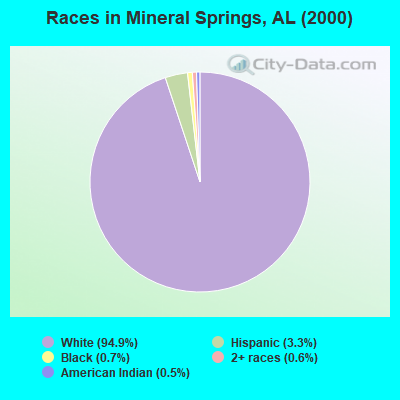
- 3,00194.9%White alone
- 1043.3%Hispanic
- 220.7%Black alone
- 190.6%Two or more races
- 150.5%American Indian alone
- 10.03%Asian alone
 Recent articles from our blog. Our writers, many of them Ph.D. graduates or candidates, create easy-to-read articles on a wide variety of topics.
Current Local Time: CST time zone
Land area: 105.1 square miles.
Population density: 32 people per square mile (very low).

| Mineral Springs CCD: | 0.3% ($268) |
| Alabama: | 0.4% ($289) |
Nearest city with pop. 50,000+: Hoover, AL  (31.0 miles , pop. 62,742).
Nearest city with pop. 200,000+: Birmingham, AL (40.1 miles , pop. 242,820).
Nearest city with pop. 1,000,000+: Houston, TX (564.1 miles , pop. 1,953,631).
Nearest cities:
), ), ), Latitude: 32.97 N, Longitude: 86.60 W
Area code commonly used in this area: 205

| Here: | 2.2% |
| Alabama: | 2.6% |
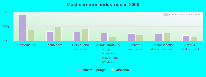
- Construction (18.1%)
- Health care (6.6%)
- Educational services (6.4%)
- Administrative & support & waste management services (5.7%)
- Finance & insurance (5.1%)
- Accommodation & food services (4.8%)
- Metal & metal products (3.7%)
- Construction (28.8%)
- Administrative & support & waste management services (7.6%)
- Metal & metal products (6.4%)
- Utilities (5.3%)
- Public administration (4.6%)
- Agriculture, forestry, fishing & hunting (3.5%)
- Truck transportation (3.4%)
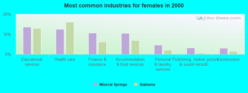
- Educational services (13.6%)
- Health care (12.5%)
- Finance & insurance (10.7%)
- Accommodation & food services (10.5%)
- Personal & laundry services (4.7%)
- Publishing, motion picture & sound recording industries (3.3%)
- Construction (3.1%)
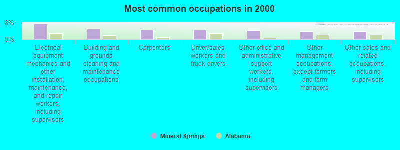
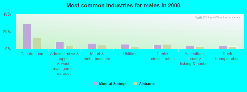
- Electrical equipment mechanics and other installation, maintenance, and repair workers, including supervisors (7.5%)
- Building and grounds cleaning and maintenance occupations (5.0%)
- Carpenters (4.6%)
- Driver/sales workers and truck drivers (4.5%)
- Other office and administrative support workers, including supervisors (4.4%)
- Other management occupations, except farmers and farm managers (3.8%)
- Other sales and related occupations, including supervisors (3.8%)
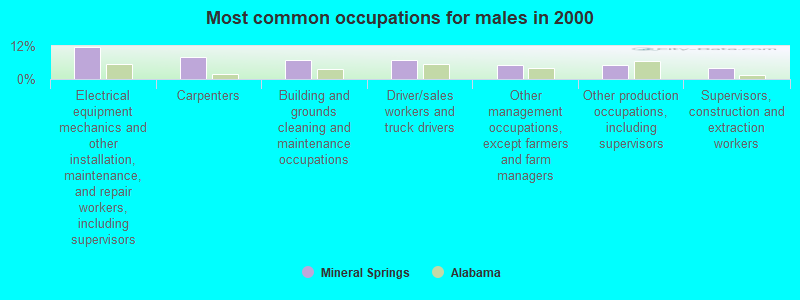
- Electrical equipment mechanics and other installation, maintenance, and repair workers, including supervisors (11.7%)
- Carpenters (8.0%)
- Building and grounds cleaning and maintenance occupations (7.1%)
- Driver/sales workers and truck drivers (6.7%)
- Other management occupations, except farmers and farm managers (5.1%)
- Other production occupations, including supervisors (4.9%)
- Supervisors, construction and extraction workers (4.0%)
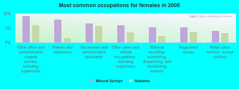
- Other office and administrative support workers, including supervisors (9.2%)
- Waiters and waitresses (8.0%)
- Secretaries and administrative assistants (6.7%)
- Other sales and related occupations, including supervisors (6.1%)
- Material recording, scheduling, dispatching, and distributing workers (5.3%)
- Registered nurses (5.3%)
- Retail sales workers, except cashiers (4.1%)
Average climate in Mineral Springs, Alabama
Based on data reported by over 4,000 weather stations


Tornado activity:
Mineral Springs-area historical tornado activity is near Alabama state average. It is 88% greater than the overall U.S. average.
On 1/24/1964, a category F4 (max. wind speeds 207-260 mph) tornado 25.8 miles away from the Mineral Springs place center killed 10 people and injured 6 people and caused between $50,000 and $500,000 in damages.
On 4/4/1977, a category F5 (max. wind speeds 261-318 mph) tornado 42.4 miles away from the place center killed 22 people and injured 130 people and caused between $5,000,000 and $50,000,000 in damages.
Earthquake activity:
Mineral Springs-area historical earthquake activity is significantly above Alabama state average. It is 100% greater than the overall U.S. average.On 1/18/1999 at 07:00:53, a magnitude 4.8 (4.8 MB, 4.0 LG, Depth: 0.6 mi, Class: Light, Intensity: IV - V) earthquake occurred 48.3 miles away from Mineral Springs center
On 4/29/2003 at 08:59:39, a magnitude 4.9 (4.4 MB, 4.6 MW, 4.9 LG) earthquake occurred 119.0 miles away from Mineral Springs center
On 10/24/1997 at 08:35:17, a magnitude 4.9 (4.8 MB, 4.2 MS, 4.9 LG, Depth: 6.2 mi) earthquake occurred 134.0 miles away from Mineral Springs center
On 6/24/1975 at 11:11:36, a magnitude 4.5 (4.5 MB) earthquake occurred 88.4 miles away from Mineral Springs center
On 4/29/2003 at 08:59:39, a magnitude 4.6 (4.6 MW, Depth: 12.3 mi) earthquake occurred 119.0 miles away from the city center
On 11/7/2004 at 11:20:21, a magnitude 4.3 (4.3 MW, Depth: 3.1 mi) earthquake occurred 80.8 miles away from the city center
Magnitude types: regional Lg-wave magnitude (LG), body-wave magnitude (MB), surface-wave magnitude (MS), moment magnitude (MW)
Natural disasters:
The number of natural disasters in Chilton County (19) is greater than the US average (15).Major Disasters (Presidential) Declared: 11
Emergencies Declared: 6
Causes of natural disasters: Floods: 8, Storms: 8, Tornadoes: 7, Hurricanes: 6, Winds: 5, Drought: 1, Snowfall: 1, Winter Storm: 1, Other: 1 (Note: some incidents may be assigned to more than one category).
Hospitals and medical centers near Mineral Springs:
- RCG CLANTON (Dialysis Facility, about 9 miles away; CLANTON, AL)
- HATLEY HEALTH CARE INC (Nursing Home, about 9 miles away; CLANTON, AL)
- SUNCREST HOME HEALTH (Home Health Center, about 9 miles away; CLANTON, AL)
- CHILTON MEDICAL CENTER (Hospital, about 9 miles away; CLANTON, AL)
- SOUTHERNCARE CLANTON (Hospital, about 9 miles away; CLANTON, AL)
- MID-SOUTH HOME HEALTH AGENCY, INC (Home Health Center, about 10 miles away; CLANTON, AL)
- COLUMBIANA HEALTH AND REHABILITATION, LLC (Nursing Home, about 15 miles away; COLUMBIANA, AL)
Colleges/universities with over 2000 students nearest to Mineral Springs:
- University of Montevallo (about 19 miles; Montevallo, AL; Full-time enrollment: 2,826)
- Samford University (about 36 miles; Birmingham, AL; FT enrollment: 3,829)
- Virginia College-Birmingham (about 37 miles; Birmingham, AL; FT enrollment: 8,167)
- Lawson State Community College-Birmingham Campus (about 38 miles; Birmingham, AL; FT enrollment: 2,695)
- University of Alabama at Birmingham (about 39 miles; Birmingham, AL; FT enrollment: 14,853)
- Alabama State University (about 46 miles; Montgomery, AL; FT enrollment: 5,457)
- Faulkner University (about 47 miles; Montgomery, AL; FT enrollment: 2,887)
Points of interest:
Notable locations in Mineral Springs: Sears Camp (A), Peach Queen Camp (B), Mount Bethel Youth Camp (C), Leighs Camp (D), Gap of The Mountain Fire and Rescue Station (E), Union Grove Volunteer Fire Department (F). Display/hide their locations on the map
Churches in Mineral Springs include: Mount Zion Church (A), New Hope Church (B), New Hope Assembly of God Church (C), Mountain Springs Methodist Church (D), Pleasant Hill Church (E), Mount Bethel Baptist Church (F), Lime Springs Methodist Church (G), Cane Creek Baptist Church (H), Archies Chapel (I). Display/hide their locations on the map
Cemeteries: Cobb Cemetery (1), Union Grove Cemetery (2), Pleasant Hill Cemetery (3), Mineral Springs Cemetery (4), Rocky Mount Cemetery (5), New Hope Cemetery (6), Mountain Springs Cemetery (7). Display/hide their locations on the map
Reservoir: Lay Lake (A). Display/hide its location on the map
Streams, rivers, and creeks: Third Creek (A), Tanyard Branch (B), Stumps Creek (C), School Branch (D), Sawmill Branch (E), Rocky Creek (F), River Branch (G), Page Creek (H), Mountain Branch (I). Display/hide their locations on the map
| This place: | 2.6 people |
| Alabama: | 2.5 people |
| This place: | 74.5% |
| Whole state: | 67.8% |
| This place: | 4.6% |
| Whole state: | 4.7% |
Likely homosexual households (counted as self-reported same-sex unmarried-partner households)
- Lesbian couples: 0.3% of all households
- Gay men: 0.3% of all households
| This place: | 16.1% |
| Whole state: | 16.1% |
| This place: | 7.5% |
| Whole state: | 7.3% |
For population 15 years and over in Mineral Springs:
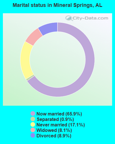
- Never married: 17.1%
- Now married: 65.9%
- Separated: 0.9%
- Widowed: 8.1%
- Divorced: 8.9%
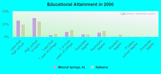
For population 25 years and over in Mineral Springs:
- High school or higher: 67.4%
- Bachelor's degree or higher: 10.9%
- Graduate or professional degree: 2.0%
- Unemployed: 3.9%
- Mean travel time to work (commute): 34.4 minutes
| Here: | 12.9 |
| Alabama average: | 13.2 |
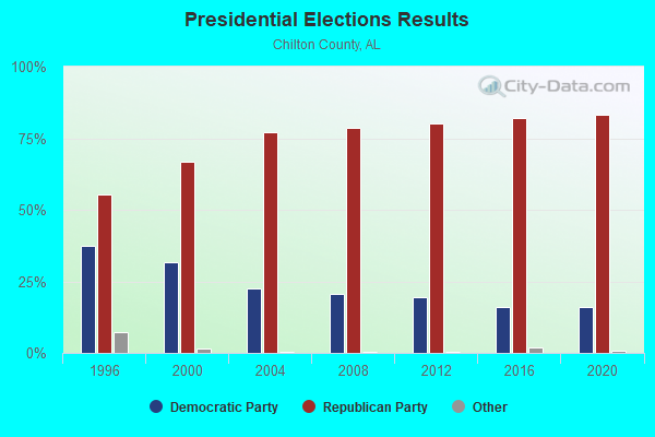
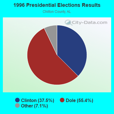
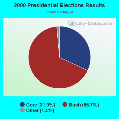


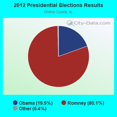
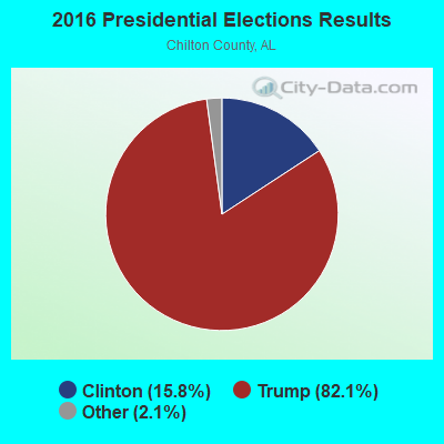
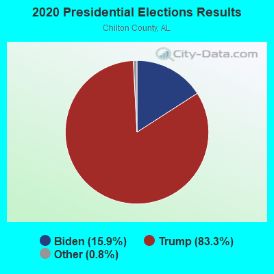
Graphs represent county-level data. Detailed 2008 Election Results
Religion statistics for Mineral Springs, AL (based on Chilton County data)
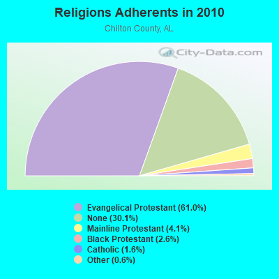
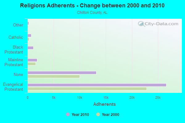
| Religion | Adherents | Congregations |
|---|---|---|
| Evangelical Protestant | 26,608 | 98 |
| Mainline Protestant | 1,805 | 14 |
| Black Protestant | 1,116 | 7 |
| Catholic | 709 | 1 |
| Other | 250 | 2 |
| None | 13,155 | - |
Food Environment Statistics:
| Here: | 1.66 / 10,000 pop. |
| Alabama: | 1.89 / 10,000 pop. |
| Here: | 0.24 / 10,000 pop. |
| Alabama: | 0.20 / 10,000 pop. |
| Chilton County: | 0.47 / 10,000 pop. |
| Alabama: | 0.65 / 10,000 pop. |
| Here: | 7.11 / 10,000 pop. |
| State: | 6.32 / 10,000 pop. |
| This county: | 4.27 / 10,000 pop. |
| Alabama: | 5.75 / 10,000 pop. |
| This county: | 9.8% |
| State: | 11.8% |
| Chilton County: | 33.9% |
| State: | 31.7% |
| Here: | 14.2% |
| State: | 13.5% |
Strongest AM radio stations in Mineral Springs:
- WJOX (690 AM; 50 kW; BIRMINGHAM, AL; Owner: CITADEL BROADCASTING COMPANY)
- WDJC (850 AM; 50 kW; BIRMINGHAM, AL; Owner: KIMTRON, INC.)
- WAPI (1070 AM; 50 kW; BIRMINGHAM, AL; Owner: CITADEL BROADCASTING COMPANY)
- WNSI (810 AM; 50 kW; JACKSONVILLE, AL; Owner: UNITED BROADCASTING NETWORK, INC.)
- WMSP (740 AM; 10 kW; MONTGOMERY, AL; Owner: CUMULUS LICENSING CORP.)
- WKNG (1060 AM; daytime; 50 kW; TALLAPOOSA, GA; Owner: WKNG, INC.)
- WACV (1170 AM; 10 kW; MONTGOMERY, AL; Owner: MONTGOMERY BROADCAST PROPERTIES, LTD)
- WQCR (1500 AM; 2 kW; ALABASTER, AL; Owner: WGTT, INC.)
- WBYE (1370 AM; 1 kW; CALERA, AL; Owner: PROGRESSIVE UNITED COMMUNICATIONS, INC.)
- WGST (640 AM; 50 kW; ATLANTA, GA; Owner: CITICASTERS LICENSES, L.P.)
- WCNN (680 AM; 50 kW; NORTH ATLANTA, GA; Owner: DICKEY BROADCASTING COMPANY)
- WERC (960 AM; 5 kW; BIRMINGHAM, AL; Owner: CAPSTAR TX LIMITED PARTNERSHIP)
- WSB (750 AM; 50 kW; ATLANTA, GA; Owner: CXR HOLDINGS, INC.)
Strongest FM radio stations in Mineral Springs:
- WEZZ-FM (97.7 FM; CLANTON, AL; Owner: SOUTHEASTERN BROADCASTING CO., INC)
- WQEM (101.5 FM; COLUMBIANA, AL; Owner: GLEN IRIS BAPTIST SCHOOL)
- WLWI-FM (92.3 FM; MONTGOMERY, AL; Owner: CUMULUS LICENSING CORP.)
- WODL (97.3 FM; HOMEWOOD, AL; Owner: CXR HOLDINGS, INC.)
- WBHK (98.7 FM; WARRIOR, AL; Owner: CXR HOLDINGS, INC.)
- WZZK-FM (104.7 FM; BIRMINGHAM, AL; Owner: CXR HOLDINGS, INC.)
- WBPT (106.9 FM; BIRMINGHAM, AL; Owner: CXR HOLDINGS, INC.)
- WGIB (91.9 FM; BIRMINGHAM, AL; Owner: GLEN IRIS BAPTIST SCHOOL)
- WYSF (94.5 FM; BIRMINGHAM, AL; Owner: CITADEL BROADCASTING COMPANY)
- WBHM (90.3 FM; BIRMINGHAM, AL; Owner: BD OF TRUSTEES/U OF AL AT BIRMINGHAM)
- WMJJ (96.5 FM; BIRMINGHAM, AL; Owner: CAPSTAR TX LIMITED PARTNERSHIP)
- WDXB (102.5 FM; JASPER, AL; Owner: CAPSTAR TX LIMITED PARTNERSHIP)
- WQEN (103.7 FM; GADSDEN, AL; Owner: CAPSTAR TX LIMITED PARTNERSHIP)
- WZRR (99.5 FM; BIRMINGHAM, AL; Owner: CITADEL BROADCASTING COMPANY)
- WDJC-FM (93.7 FM; BIRMINGHAM, AL; Owner: KIMTRON, INC.)
- WTBJ (91.3 FM; OXFORD, AL; Owner: TRINITY CHRISTIAN ACADEMY)
- WMXS (103.3 FM; MONTGOMERY, AL; Owner: CUMULUS LICENSING CORP.)
- WANZ (100.7 FM; NORTHPORT, AL; Owner: APEX BRAODCASTING INC.)
- WLJR (88.5 FM; BIRMINGHAM, AL; Owner: BRIARWOOD PRESBYTERIAN CHURCH)
- WTRB-FM (98.3 FM; SYLACAUGA, AL; Owner: WILLIAMS COMMUNICATIONS, INC.)
TV broadcast stations around Mineral Springs:
- WBIH (Channel 29; SELMA, AL; Owner: FLINN BROADCASTING CORPORATION)
- WNCF (Channel 32; MONTGOMERY, AL; Owner: CHANNEL 32 MONTGOMERY LLC)
- WIAT (Channel 42; BIRMINGHAM, AL; Owner: MEDIA GENERAL COMMUNICATIONS, INC.)
- WDBB (Channel 17; BESSEMER, AL; Owner: WDBB-TV, INC.)
- WBIQ (Channel 10; BIRMINGHAM, AL; Owner: ALABAMA EDUCATIONAL TELEVISION COMMISSION)
- WCFT-TV (Channel 33; TUSCALOOSA, AL; Owner: TV ALABAMA, INCORPORATED)
- WABM (Channel 68; BIRMINGHAM, AL; Owner: BIRMINGHAM (WABM-TV) LICENSEE, INC.)
- WTTO (Channel 21; HOMEWOOD, AL; Owner: WTTO LICENSEE, LLC)
- WBRC (Channel 6; BIRMINGHAM, AL; Owner: WBRC LICENSE, INC.)
- WVTM-TV (Channel 13; BIRMINGHAM, AL; Owner: BIRMINGHAM BROADCASTING (WVTM-TV), LLC)
- WAKA (Channel 8; SELMA, AL; Owner: ALABAMA BROADCASTING PARTNERS)
FCC Registered Broadcast Land Mobile Towers:
1- On Rural Cr 3/8 Mi S Mims Cross Rd (Lat: 32.960667 Lon: -86.655528), Call Sign: KGT655, Licensee ID: L00010271,
Assigned Frequencies: 452.175 MHz, 452.175 MHz, Grant Date: 05/16/2002, Expiration Date: 06/16/2012, Cancellation Date: 08/18/2012, Registrant: Charles Culp, 11602 Cr 51, Jemison, AL 35085, Phone: (205) 688-4553
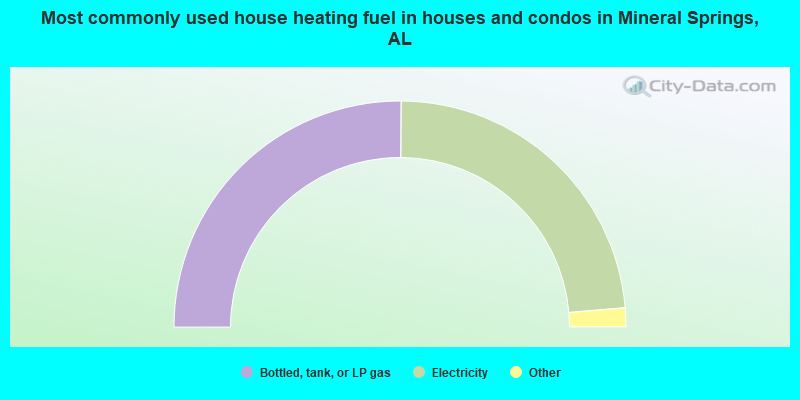
- 50.2%Bottled, tank, or LP gas
- 47.1%Electricity
- 1.3%Utility gas
- 0.7%Wood
- 0.6%No fuel used
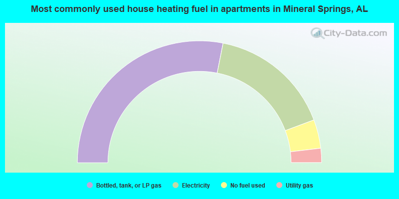
- 56.2%Bottled, tank, or LP gas
- 32.4%Electricity
- 7.6%No fuel used
- 3.8%Utility gas
Mineral Springs compared to Alabama state average:
- Unemployed percentage significantly below state average.
- Black race population percentage significantly below state average.
- Median age below state average.
- Foreign-born population percentage significantly below state average.
- Length of stay since moving in significantly above state average.
- Number of rooms per house significantly below state average.
- House age significantly below state average.
- Number of college students below state average.
- Percentage of population with a bachelor's degree or higher below state average.
Mineral Springs on our top lists:
- #61 on the list of "Top 101 cities with the largest percentage of people in unknown juvenile institutions (population 1,000+)"