Mizpah-Pumpkin, Montana
Submit your own pictures of this place and show them to the world
- OSM Map
- Google Map
- MSN Map
| Males: 215 | |
| Females: 189 |
| Median resident age: | 42.3 years |
| Montana median age: | 37.5 years |
Zip code: 59301
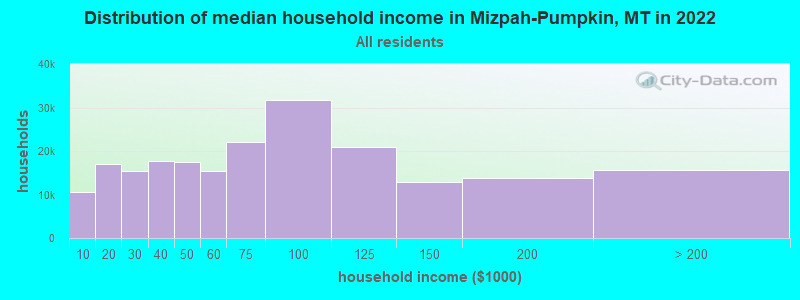
| Mizpah-Pumpkin: | $62,302 |
| MT: | $67,631 |
Estimated per capita income in 2022: $31,165 (it was $14,023 in 2000)
Mizpah-Pumpkin CCD income, earnings, and wages data
Estimated median house or condo value in 2022: $407,784 (it was $106,300 in 2000)
| Mizpah-Pumpkin: | $407,784 |
| MT: | $366,400 |
Mizpah-Pumpkin, MT residents, houses, and apartments details
Detailed information about poverty and poor residents in Mizpah-Pumpkin, MT
Compare current foreclosures near your location:
| Photo | Address | Area | Beds / Baths | Price | Details |
|---|---|---|---|---|---|

|
#1
Bayberry Cir
Columbus, OH 43207
|
1,564 sq. feet
|
1 baths 3 beds |
$127,500
|
show details |

|
#2
S High St
Columbus, OH 43207
|
1,678 sq. feet
|
2 baths 4 beds |
$31,900
|
show details |

|
#3
E 21st Ave
Columbus, OH 43211
|
1,061 sq. feet
|
1 baths 3 beds |
$179,900
|
show details |

|
#4
S Hague Ave
Columbus, OH 43204
|
979 sq. feet
|
1 baths 2 beds |
show details | |

|
#5
Hiawatha Park Dr
Columbus, OH 43211
|
1,278 sq. feet
|
1 baths 4 beds |
show details | |

|
#6
Hamilton Ave
Columbus, OH 43211
|
1,061 sq. feet
|
1 baths 3 beds |
show details | |

|
#7
Grasmere Ave
Columbus, OH 43211
|
720 sq. feet
|
1 baths 2 beds |
show details | |

|
#8
Striebel Ct
Columbus, OH 43227
|
925 sq. feet
|
1 baths 3 beds |
show details | |

|
#9
Kelton Ave
Columbus, OH 43206
|
1,080 sq. feet
|
1 baths 3 beds |
show details | |

|
#10
Summertree Ln
Westerville, OH 43081
|
2,496 sq. feet
|
2 baths 3 beds |
show details |
| Photo | Address | Area | Beds / Baths | Price | Details |
|---|---|---|---|---|---|

|
#11
E Welch Ave
Columbus, OH 43207
|
1,864 sq. feet
|
2 baths 4 beds |
show details | |

|
#12
Fergus Rd
Grove City, OH 43123
|
3,312 sq. feet
|
2 baths 4 beds |
show details | |

|
#13
Upton Rd E
Columbus, OH 43232
|
852 sq. feet
|
1 baths 3 beds |
show details | |

|
#14
Chester Rd
Columbus, OH 43221
|
3,300 sq. feet
|
4 baths 5 beds |
show details | |

|
#15
Executive Ct
Westerville, OH 43081
|
1,811 sq. feet
|
2 baths 3 beds |
show details | |

|
#16
E Howard Rd
Columbus, OH 43207
|
1,056 sq. feet
|
1 baths 3 beds |
show details | |

|
#17
Cannonade Ct
Columbus, OH 43230
|
2,023 sq. feet
|
2 baths 3 beds |
show details | |

|
#18
Fairfield Ave
Columbus, OH 43203
|
984 sq. feet
|
1 baths 2 beds |
show details | |

|
#19
E Lincoln Ave
Columbus, OH 43214
|
874 sq. feet
|
1 baths 3 beds |
show details | |

|
#20
S Champion Ave
Columbus, OH 43207
|
1,157 sq. feet
|
1 baths 2 beds |
show details |
| Photo | Address | Area | Beds / Baths | Price | Details |
|---|---|---|---|---|---|

|
#21
Wrexham Ave
Columbus, OH 43223
|
1,235 sq. feet
|
1 baths 3 beds |
show details | |

|
#22
Armada Rd
Columbus, OH 43232
|
1,028 sq. feet
|
1 baths 4 beds |
show details | |

|
#23
Falls Peak Ln
Delaware, OH 43015
|
1,352 sq. feet
|
2 baths 2 beds |
show details | |

|
#24
N Roys Ave
Columbus, OH 43204
|
1,248 sq. feet
|
2 baths 3 beds |
show details | |

|
#25
Meadowbrook Dr
Columbus, OH 43207
|
1,752 sq. feet
|
2 baths 4 beds |
show details | |

|
#26
Glenmate Ct
Columbus, OH 43223
|
1,050 sq. feet
|
1 baths 3 beds |
show details | |

|
#27
High Free Pike
West Jefferson, OH 43162
|
1,216 sq. feet
|
2 baths 4 beds |
show details | |

|
#28
Stoneybrook Blvd # 21a
Hilliard, OH 43026
|
1,231 sq. feet
|
2 baths 3 beds |
show details | |

|
#29
Chidley St
Galloway, OH 43119
|
1,502 sq. feet
|
1 baths 3 beds |
show details | |

|
#30
London Groveport Rd
Grove City, OH 43123
|
816 sq. feet
|
1 baths 2 beds |
show details |
| Photo | Address | Area | Beds / Baths | Price | Details |
|---|---|---|---|---|---|

|
#31
Kingsglen Dr
Grove City, OH 43123
|
1,635 sq. feet
|
2 baths 4 beds |
show details | |

|
#32
S Richardson Ave
Columbus, OH 43204
|
1,520 sq. feet
|
2 baths 3 beds |
show details | |

|
#33
Whittman Ct
Plain City, OH 43064
|
3,186 sq. feet
|
3 baths 4 beds |
show details | |

|
#34
N 18th St
Columbus, OH 43203
|
1,690 sq. feet
|
1 baths 4 beds |
show details | |

|
#35
Marshrun Dr
Grove City, OH 43123
|
2,036 sq. feet
|
2 baths 4 beds |
show details | |

|
#36
Gladys Rd
Columbus, OH 43228
|
832 sq. feet
|
1 baths 3 beds |
show details | |

|
#37
Ashgrove Dr
Grove City, OH 43123
|
1,772 sq. feet
|
2 baths 4 beds |
show details | |

|
#38
Elaine Rd
Columbus, OH 43213
|
764 sq. feet
|
1 baths 2 beds |
show details | |

|
#39
Midland Ave
Columbus, OH 43223
|
1,518 sq. feet
|
1 baths 2 beds |
show details | |

|
#40
Brookstone Dr
Westerville, OH 43082
|
1,783 sq. feet
|
3 baths 3 beds |
show details |
| Photo | Address | Area | Beds / Baths | Price | Details |
|---|---|---|---|---|---|

|
#41
Scottwood Rd
Columbus, OH 43227
|
1,008 sq. feet
|
1 baths 3 beds |
show details | |

|
#42
Hildreth Ave
Columbus, OH 43203
|
1,798 sq. feet
|
2 baths 4 beds |
show details | |

|
#43
Lehner Rd
Columbus, OH 43224
|
1,628 sq. feet
|
2 baths 4 beds |
show details | |

|
#44
Morality Dr
Columbus, OH 43231
|
1,903 sq. feet
|
2 baths 4 beds |
show details | |

|
#45
Belfast Dr
Columbus, OH 43227
|
1,142 sq. feet
|
2 baths 3 beds |
show details | |

|
#46
Doral Ave
Columbus, OH 43213
|
2,008 sq. feet
|
2 baths 4 beds |
show details | |

|
#47
S Cypress Ave
Columbus, OH 43222
|
1,508 sq. feet
|
1 baths 3 beds |
show details | |

|
#48
Bucknell Rd
Columbus, OH 43213
|
1,054 sq. feet
|
1 baths 3 beds |
show details | |

|
#49
Pegwood Dr
Columbus, OH 43229
|
878 sq. feet
|
1 baths 1 beds |
show details | |

|
Check over 1 million property listings on Foreclosure.com!
|
browse all offers | |||

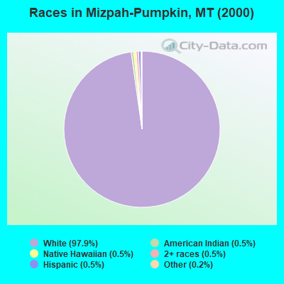
- 41697.9%White alone
- 20.5%American Indian alone
- 20.5%Native Hawaiian and Other
Pacific Islander alone - 20.5%Two or more races
- 20.5%Hispanic
- 10.2%Other race alone
Races in Mizpah-Pumpkin detailed stats: ancestries, foreign born residents, place of birth
 Recent articles from our blog. Our writers, many of them Ph.D. graduates or candidates, create easy-to-read articles on a wide variety of topics.
Current Local Time: MST time zone
Land area: 1981.5 square miles.
Population density: 0.2 people per square mile (very low).
| Mizpah-Pumpkin CCD: | 0.5% ($500) |
| Montana: | 1.3% ($1,212) |
Nearest city with pop. 50,000+: Billings, MT  (133.7 miles , pop. 89,847).
Nearest city with pop. 200,000+: West Adams, CO (429.9 miles , pop. 259,628).
Nearest city with pop. 1,000,000+: Phoenix, AZ (928.4 miles , pop. 1,321,045).
Nearest cities:
), ), )Latitude: 46.06 N, Longitude: 105.79 W
Area code commonly used in this area: 406
| Here: | 3.6% |
| Montana: | 3.8% |
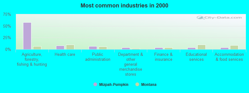
- Agriculture, forestry, fishing & hunting (57.8%)
- Health care (8.3%)
- Public administration (6.8%)
- Department & other general merchandise stores (3.9%)
- Finance & insurance (3.9%)
- Educational services (3.9%)
- Accommodation & food services (3.9%)
- Agriculture, forestry, fishing & hunting (71.6%)
- Public administration (7.5%)
- Construction (4.5%)
- Department & other general merchandise stores (4.5%)
- Accommodation & food services (3.0%)
- Educational services (2.2%)
- Health care (2.2%)
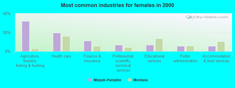
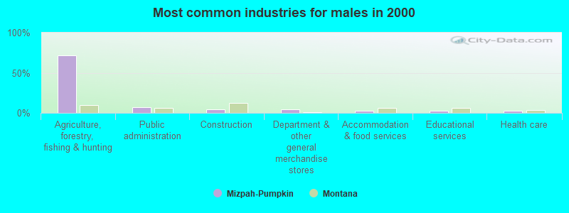
- Agriculture, forestry, fishing & hunting (31.9%)
- Health care (19.4%)
- Finance & insurance (11.1%)
- Professional, scientific, technical services (6.9%)
- Educational services (6.9%)
- Public administration (5.6%)
- Accommodation & food services (5.6%)
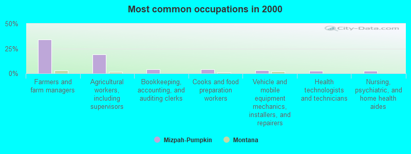
- Farmers and farm managers (34.0%)
- Agricultural workers, including supervisors (18.9%)
- Bookkeeping, accounting, and auditing clerks (4.4%)
- Cooks and food preparation workers (3.9%)
- Vehicle and mobile equipment mechanics, installers, and repairers (2.9%)
- Health technologists and technicians (2.4%)
- Nursing, psychiatric, and home health aides (2.4%)

- Farmers and farm managers (44.0%)
- Agricultural workers, including supervisors (24.6%)
- Vehicle and mobile equipment mechanics, installers, and repairers (4.5%)
- Cooks and food preparation workers (3.0%)
- Preschool, kindergarten, elementary, and middle school teachers (2.2%)
- Judges, magistrates, and other judicial workers (2.2%)
- Building and grounds cleaning and maintenance occupations (2.2%)

- Farmers and farm managers (15.3%)
- Bookkeeping, accounting, and auditing clerks (12.5%)
- Agricultural workers, including supervisors (8.3%)
- Health technologists and technicians (6.9%)
- Other office and administrative support workers, including supervisors (6.9%)
- Cooks and food preparation workers (5.6%)
- Supervisors and other personal care and service workers, except child care workers (5.6%)
Average climate in Mizpah-Pumpkin, Montana
Based on data reported by over 4,000 weather stations


(lower is better)
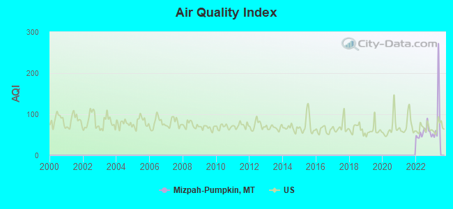
Air Quality Index (AQI) level in 2022 was 55.3. This is better than average.
| City: | 55.3 |
| U.S.: | 72.6 |
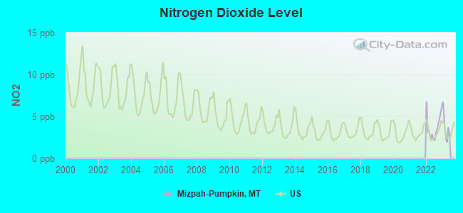
Nitrogen Dioxide (NO2) [ppb] level in 2022 was 3.73. This is better than average. Closest monitor was 24.1 miles away from the city center.
| City: | 3.73 |
| U.S.: | 5.11 |
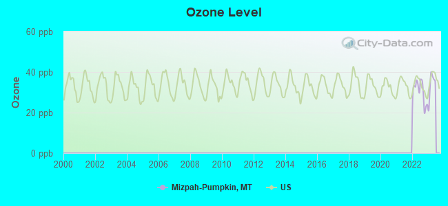
Ozone [ppb] level in 2022 was 30.2. This is about average. Closest monitor was 24.1 miles away from the city center.
| City: | 30.2 |
| U.S.: | 33.3 |
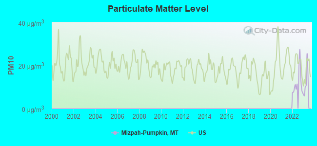
Particulate Matter (PM10) [µg/m3] level in 2022 was 12.1. This is significantly better than average. Closest monitor was 24.1 miles away from the city center.
| City: | 12.1 |
| U.S.: | 19.2 |
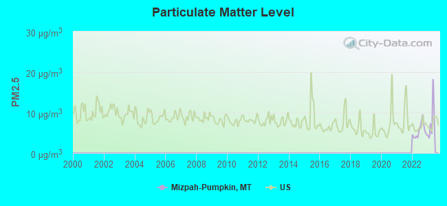
Particulate Matter (PM2.5) [µg/m3] level in 2022 was 5.48. This is significantly better than average. Closest monitor was 24.1 miles away from the city center.
| City: | 5.48 |
| U.S.: | 8.11 |
Earthquake activity:
Mizpah-Pumpkin-area historical earthquake activity is significantly above Montana state average. It is 346% greater than the overall U.S. average.On 8/18/1959 at 06:37:13, a magnitude 7.7 (7.7 UK, Class: Major, Intensity: VIII - XII) earthquake occurred 258.4 miles away from the city center, causing $26,000,000 total damage
On 10/28/1983 at 14:06:06, a magnitude 7.3 (6.2 MB, 7.3 MS, 7.0 MW) earthquake occurred 414.7 miles away from Mizpah-Pumpkin center, causing 2 deaths (2 shaking deaths) and 3 injuries, causing $15,000,000 total damage
On 6/30/1975 at 18:54:13, a magnitude 6.1 (5.6 MB, 5.9 MS, 6.1 UK, 6.1 ML, Class: Strong, Intensity: VII - IX) earthquake occurred 259.0 miles away from Mizpah-Pumpkin center
On 9/8/1984 at 00:59:31, a magnitude 5.1 (5.1 MB, Class: Moderate, Intensity: VI - VII) earthquake occurred 127.0 miles away from Mizpah-Pumpkin center
On 5/29/1984 at 20:18:32, a magnitude 5.0 (5.0 MB) earthquake occurred 126.9 miles away from Mizpah-Pumpkin center
On 10/18/1984 at 15:30:23, a magnitude 5.5 (5.4 MB, 5.1 MS, 5.5 ML) earthquake occurred 253.9 miles away from Mizpah-Pumpkin center
Magnitude types: body-wave magnitude (MB), local magnitude (ML), surface-wave magnitude (MS), moment magnitude (MW)
Natural disasters:
The number of natural disasters in Custer County (7) is smaller than the US average (15).Major Disasters (Presidential) Declared: 4
Emergencies Declared: 1
Causes of natural disasters: Floods: 3, Fire: 1, Hurricane: 1, Storm: 1, Winter Storm: 1, Other: 1 (Note: some incidents may be assigned to more than one category).
Colleges/universities with over 2000 students nearest to Mizpah-Pumpkin:
- Sheridan College (about 106 miles; Sheridan, WY; Full-time enrollment: 2,070)
- Montana State University-Billings (about 133 miles; Billings, MT; FT enrollment: 4,319)
- Black Hills State University (about 143 miles; Spearfish, SD; FT enrollment: 3,166)
- South Dakota School of Mines and Technology (about 187 miles; Rapid City, SD; FT enrollment: 2,102)
- Casper College (about 226 miles; Casper, WY; FT enrollment: 2,770)
- Bismarck State College (about 243 miles; Bismarck, ND; FT enrollment: 3,015)
- University of Mary (about 245 miles; Bismarck, ND; FT enrollment: 2,854)
Points of interest:
Notable locations in Mizpah-Pumpkin: Allen Ranch (A), Balsam Ranch (B), Bear Jaw Windmill (C), Horton (D), Woodruff Park (E), Kohones Ranch (F), Twelve Mile Dam Fishing Access Site (G), Sunshine Camp (H). Display/hide their locations on the map
Church in Mizpah-Pumpkin: Grace Community Church (A). Display/hide its location on the map
Reservoirs: Pine Hill Reservoir (A), Willie Reservoir (B), Witcher Reservoir (C), Jones Reservoir (D), Morgan Creek Reservoir (E), Love Reservoir (F), Corral Creek Reservoir (G), Pine Hills Reservoir (H). Display/hide their locations on the map
Creeks: Yank Creek (A), Coon Creek (B), Scott Creek (C), May Creek (D), Anderson Creek (E), Basin Creek (F), Bear Jaw Creek (G), Betz Creek (H), Broughton Creek (I). Display/hide their locations on the map
| This place: | 2.5 people |
| Montana: | 2.5 people |
| This place: | 56.2% |
| Whole state: | 66.6% |
| This place: | 5.3% |
| Whole state: | 5.0% |
Likely homosexual households (counted as self-reported same-sex unmarried-partner households)
- Lesbian couples: 0.6% of all households
- Gay men: 0.6% of all households
| This place: | 26.0% |
| Whole state: | 14.6% |
| This place: | 10.1% |
| Whole state: | 5.8% |
For population 15 years and over in Mizpah-Pumpkin:
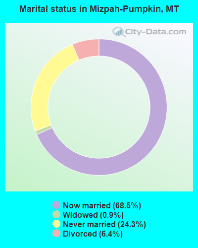
- Never married: 24.3%
- Now married: 68.5%
- Separated: 0.0%
- Widowed: 0.9%
- Divorced: 6.4%
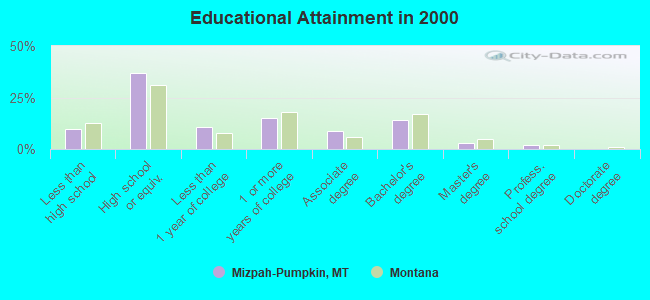
For population 25 years and over in Mizpah-Pumpkin:
- High school or higher: 90.1%
- Bachelor's degree or higher: 18.8%
- Graduate or professional degree: 4.6%
- Unemployed: 5.9%
- Mean travel time to work (commute): 25.2 minutes
| Here: | 8.9 |
| Montana average: | 10.4 |
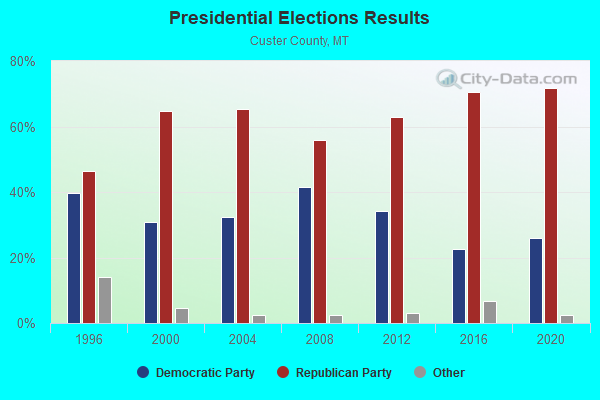
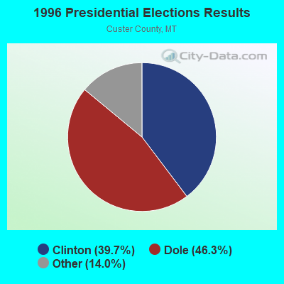


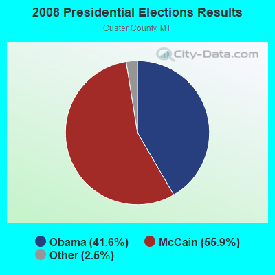
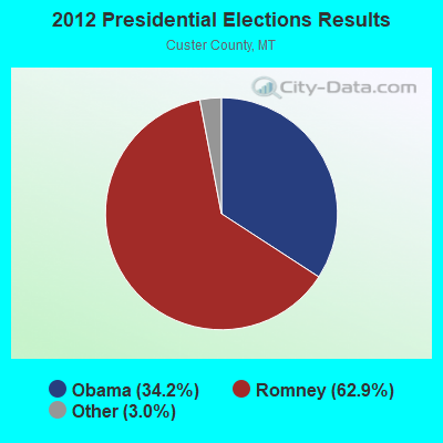
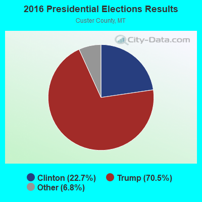
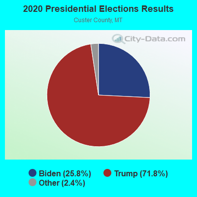
Graphs represent county-level data. Detailed 2008 Election Results
Religion statistics for Mizpah-Pumpkin, MT (based on Custer County data)
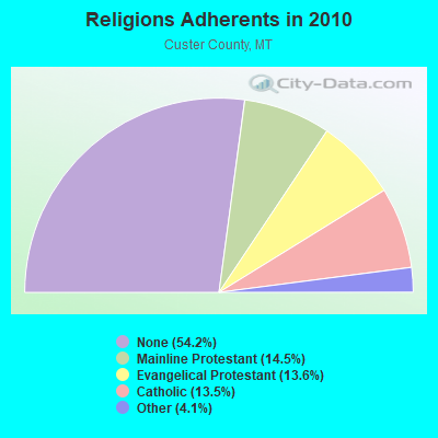
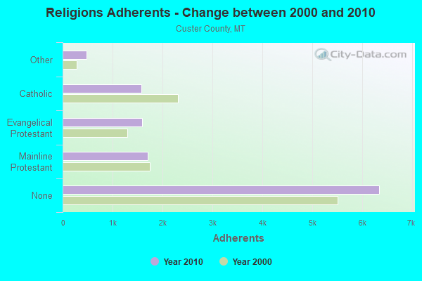
| Religion | Adherents | Congregations |
|---|---|---|
| Mainline Protestant | 1,699 | 7 |
| Evangelical Protestant | 1,594 | 9 |
| Catholic | 1,580 | 1 |
| Other | 483 | 1 |
| None | 6,343 | - |
Food Environment Statistics:
| Here: | 1.79 / 10,000 pop. |
| State: | 2.55 / 10,000 pop. |
| Custer County: | 8.06 / 10,000 pop. |
| Montana: | 4.69 / 10,000 pop. |
| This county: | 8.96 / 10,000 pop. |
| Montana: | 10.38 / 10,000 pop. |
| Custer County: | 8.3% |
| Montana: | 7.2% |
| Custer County: | 25.8% |
| Montana: | 23.1% |
| This county: | 15.3% |
| State: | 10.7% |
Strongest AM radio stations in Mizpah-Pumpkin:
- KATL (770 AM; 10 kW; MILES CITY, MT; Owner: STAR PRINTING COMPANY)
- KMTA (1050 AM; 10 kW; MILES CITY, MT; Owner: SENGER BROADCASTING CORPORATION)
- KIKC (1250 AM; 5 kW; FORSYTH, MT; Owner: MILES CITY, FORSYTH B/DCSTG, INC.)
- KBHB (810 AM; 25 kW; STURGIS, SD; Owner: MONTEREY LICENSES, LLC)
- KXMR (710 AM; 50 kW; BISMARCK, ND; Owner: RADIO BISMARCK MANDAN, LLC)
- KTWO (1030 AM; 50 kW; CASPER, WY; Owner: CITICASTERS LICENSES, L.P.)
- KFLN (960 AM; 5 kW; BAKER, MT; Owner: NEWELL BROADCASTING INC.)
- KUYO (830 AM; daytime; 25 kW; EVANSVILLE, WY; Owner: WYOMING CHRISTIAN BROADCASTING COMPANY)
- KROE (930 AM; 5 kW; SHERIDAN, WY; Owner: LOVCOM, INC.)
- KLTT (670 AM; 50 kW; COMMERCE CITY, CO; Owner: KLZ RADIO, INC.)
- KERR (750 AM; 50 kW; POLSON, MT; Owner: ANDERSON RADIO BROADCASTING, INC.)
- KURL (730 AM; 5 kW; BILLINGS, MT; Owner: ELENBAAS MEDIA, INC.)
- KKZN (760 AM; 50 kW; THORNTON, CO; Owner: JACOR BROADCASTING OF COLORADO, INC.)
Strongest FM radio stations in Mizpah-Pumpkin:
- KKRY (92.5 FM; MILES CITY, MT; Owner: SENGER BROADCASTING CORPORATION)
- KIKC-FM (101.3 FM; FORSYTH, MT; Owner: MILES CITY, FORSYTH B/CSTG, INC.)
- KECC (90.7 FM; MILES CITY, MT; Owner: MONTANA STATE UNIVERSITY -BILLINGS)
- K206BN (89.1 FM; ASHLAND, MT; Owner: MONTANA STATE UNIVERSITY-BILLINGS)
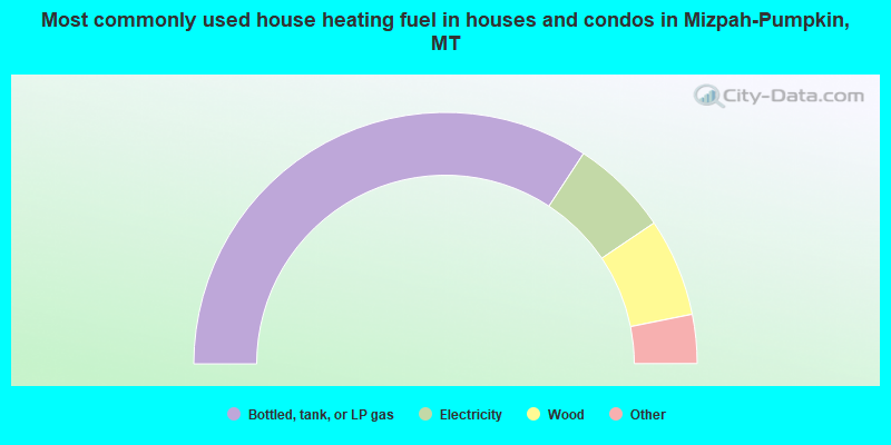
- 68.5%Bottled, tank, or LP gas
- 12.6%Electricity
- 12.6%Wood
- 3.6%Coal or coke
- 2.7%No fuel used
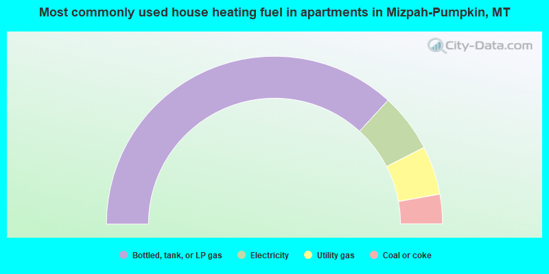
- 73.6%Bottled, tank, or LP gas
- 11.3%Electricity
- 9.4%Utility gas
- 5.7%Coal or coke
Mizpah-Pumpkin compared to Montana state average:
- Unemployed percentage below state average.
- Black race population percentage significantly below state average.
- Hispanic race population percentage significantly below state average.
- Foreign-born population percentage significantly below state average.
- Renting percentage significantly below state average.
- Length of stay since moving in significantly above state average.
- Number of rooms per house significantly below state average.
- House age significantly below state average.
- Number of college students below state average.
Mizpah-Pumpkin on our top lists:
- #51 on the list of "Top 100 cities with largest land areas"
- #56 on the list of "Top 100 highest located cities (pop. 50,000+)"