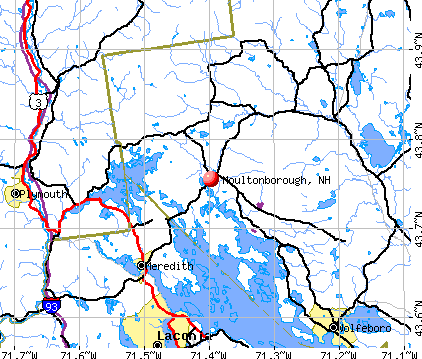
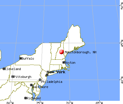
Moultonborough, New Hampshire

Moultonborough: Sunrise from Lee's Pond, Moultonborough

Moultonborough: Overlooking Lake Winnipesaukee from Moultonborough, NH, Long Island

Moultonborough: Overlooking Lake Winnipesaukee and Gunstock Mountain from Moultonborough, NH

Moultonborough: Overlooking Lake Winnipesaukee from Moultonborough, NH, Long Island
- add
your
Submit your own pictures of this town and show them to the world
- OSM Map
- General Map
- Google Map
- MSN Map
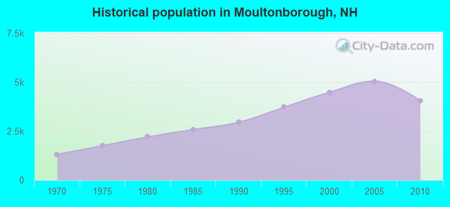
Population change since 2000: -9.8%
 |
| Males: 2,005 | |
| Females: 2,039 |
| Median resident age: | 50.5 years |
| New Hampshire median age: | 43.9 years |
Zip codes: 03254.
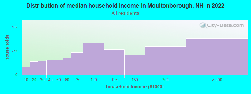
| Moultonborough: | $85,983 |
| NH: | $89,992 |
Estimated per capita income in 2022: $57,763 (it was $25,733 in 2000)
Moultonborough town income, earnings, and wages data
Estimated median house or condo value in 2022: $485,826 (it was $158,800 in 2000)
| Moultonborough: | $485,826 |
| NH: | $384,700 |
Mean prices in 2022: all housing units: $505,201; detached houses: $542,950; townhouses or other attached units: $363,532; in 2-unit structures: $373,773; in 3-to-4-unit structures: $587,160; in 5-or-more-unit structures: $313,992; mobile homes: $113,714; occupied boats, rvs, vans, etc.: $118,400
Moultonborough, NH residents, houses, and apartments details
Detailed information about poverty and poor residents in Moultonborough, NH


- 3,93497.3%White alone
- 421.0%Hispanic
- 230.6%Asian alone
- 210.5%Two or more races
- 110.3%Black alone
- 70.2%American Indian alone
- 60.1%Other race alone
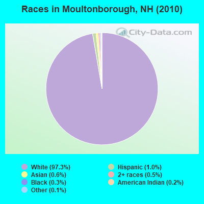
Races in Moultonborough detailed stats: ancestries, foreign born residents, place of birth
According to our research of New Hampshire and other state lists, there were 7 registered sex offenders living in Moultonborough, New Hampshire as of May 17, 2024.
The ratio of all residents to sex offenders in Moultonborough is 578 to 1.
The ratio of registered sex offenders to all residents in this city is near the state average.
Type |
2009 |
2010 |
2011 |
2012 |
2013 |
2014 |
2015 |
2016 |
2017 |
2018 |
2019 |
2020 |
2021 |
2022 |
|---|---|---|---|---|---|---|---|---|---|---|---|---|---|---|
| Murders (per 100,000) | 0 (0.0) | 0 (0.0) | 0 (0.0) | 0 (0.0) | 0 (0.0) | 0 (0.0) | 0 (0.0) | 0 (0.0) | 0 (0.0) | 0 (0.0) | 0 (0.0) | 0 (0.0) | 0 (0.0) | 0 (0.0) |
| Rapes (per 100,000) | 0 (0.0) | 0 (0.0) | 0 (0.0) | 4 (99.1) | 4 (99.5) | 2 (49.7) | 0 (0.0) | 2 (49.9) | 1 (24.8) | 0 (0.0) | 0 (0.0) | 2 (47.6) | 0 (0.0) | 1 (19.1) |
| Robberies (per 100,000) | 0 (0.0) | 0 (0.0) | 0 (0.0) | 0 (0.0) | 0 (0.0) | 0 (0.0) | 0 (0.0) | 0 (0.0) | 1 (24.8) | 0 (0.0) | 0 (0.0) | 0 (0.0) | 0 (0.0) | 0 (0.0) |
| Assaults (per 100,000) | 4 (79.3) | 7 (173.1) | 2 (49.4) | 2 (49.5) | 3 (74.6) | 0 (0.0) | 1 (24.9) | 3 (74.9) | 0 (0.0) | 1 (24.4) | 0 (0.0) | 2 (47.6) | 4 (94.6) | 0 (0.0) |
| Burglaries (per 100,000) | 17 (337.2) | 26 (642.9) | 19 (469.3) | 29 (718.4) | 15 (372.9) | 5 (124.3) | 4 (99.8) | 8 (199.6) | 3 (74.3) | 1 (24.4) | 5 (119.8) | 2 (47.6) | 0 (0.0) | 1 (19.1) |
| Thefts (per 100,000) | 48 (952.2) | 62 (1,533) | 47 (1,161) | 51 (1,263) | 52 (1,293) | 48 (1,193) | 35 (873.0) | 34 (848.3) | 30 (742.9) | 22 (536.8) | 20 (479.2) | 16 (381.1) | 25 (591.4) | 8 (152.8) |
| Auto thefts (per 100,000) | 2 (39.7) | 2 (49.5) | 3 (74.1) | 1 (24.8) | 3 (74.6) | 1 (24.9) | 0 (0.0) | 1 (25.0) | 6 (148.6) | 3 (73.2) | 0 (0.0) | 0 (0.0) | 1 (23.7) | 1 (19.1) |
| Arson (per 100,000) | 2 (39.7) | 0 (0.0) | 0 (0.0) | 0 (0.0) | 0 (0.0) | 0 (0.0) | 0 (0.0) | 0 (0.0) | 0 (0.0) | 0 (0.0) | 0 (0.0) | 0 (0.0) | 0 (0.0) | 0 (0.0) |
| City-Data.com crime index | 80.7 | 144.9 | 95.1 | 192.0 | 178.3 | 98.2 | 46.9 | 104.8 | 74.0 | 33.9 | 27.6 | 66.2 | 44.5 | 24.3 |
The City-Data.com crime index weighs serious crimes and violent crimes more heavily. Higher means more crime, U.S. average is 246.1. It adjusts for the number of visitors and daily workers commuting into cities.
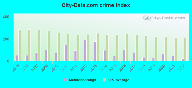
Crime rate in Moultonborough detailed stats: murders, rapes, robberies, assaults, burglaries, thefts, arson
Full-time law enforcement employees in 2021, including police officers: 9 (8 officers - 6 male; 2 female).
| Officers per 1,000 residents here: | 1.89 |
| New Hampshire average: | 2.14 |
 Recent articles from our blog. Our writers, many of them Ph.D. graduates or candidates, create easy-to-read articles on a wide variety of topics.

 | Move to NH - Suggested Areas & Towns? (108 replies) |
| New Yorkers Using Ski Condos Year Round Residences? (39 replies) |
| What can NH do? (61 replies) |
| NH democrats try once again to enact back door income tax. (55 replies) |
| Anti Mask gets Defeated in New Hampshire Small Town (1 reply) |
| NH town suggestions? Retirement (14 replies) |
Latest news from Moultonborough, NH collected exclusively by city-data.com from local newspapers, TV, and radio stations
Ancestries: English (23.4%), Irish (19.1%), German (12.2%), French (8.4%), Italian (8.2%), French Canadian (7.0%).
Current Local Time: EST time zone
Incorporated in 1777
Elevation: 598 feet
Land area: 59.8 square miles.
Population density: 68 people per square mile (very low).
158 residents are foreign born (2.4% Europe, 0.8% North America).
| This town: | 3.5% |
| New Hampshire: | 4.4% |
| Moultonborough town: | 1.2% ($1,906) |
| New Hampshire: | 2.3% ($2,946) |
Nearest city with pop. 50,000+: Manchester, NH  (50.3 miles , pop. 107,006).
Nearest city with pop. 200,000+: Boston, MA (97.4 miles , pop. 589,141).
Nearest city with pop. 1,000,000+: Bronx, NY (235.3 miles , pop. 1,332,650).
Nearest cities:
), ), Latitude: 43.71 N, Longitude: 71.39 W
Area code commonly used in this area: 603
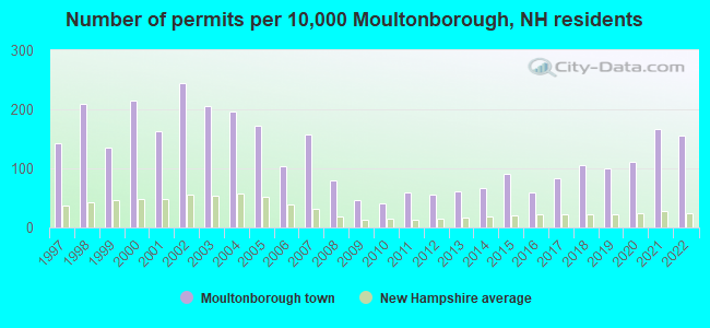
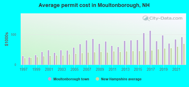
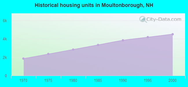
Single-family new house construction building permits:
- 2022: 70 buildings, average cost: $466,100
- 2021: 75 buildings, average cost: $422,900
- 2020: 50 buildings, average cost: $356,600
- 2019: 45 buildings, average cost: $492,100
- 2018: 47 buildings, average cost: $398,000
- 2017: 37 buildings, average cost: $570,600
- 2016: 27 buildings, average cost: $528,800
- 2015: 41 buildings, average cost: $414,800
- 2014: 30 buildings, average cost: $409,900
- 2013: 28 buildings, average cost: $402,800
- 2012: 25 buildings, average cost: $297,700
- 2011: 27 buildings, average cost: $318,900
- 2010: 18 buildings, average cost: $392,400
- 2009: 21 buildings, average cost: $355,200
- 2008: 36 buildings, average cost: $432,900
- 2007: 71 buildings, average cost: $408,600
- 2006: 46 buildings, average cost: $346,400
- 2005: 77 buildings, average cost: $290,600
- 2004: 88 buildings, average cost: $242,200
- 2003: 92 buildings, average cost: $247,200
- 2002: 110 buildings, average cost: $202,900
- 2001: 73 buildings, average cost: $245,300
- 2000: 96 buildings, average cost: $216,800
- 1999: 61 buildings, average cost: $163,500
- 1998: 94 buildings, average cost: $128,300
- 1997: 64 buildings, average cost: $149,300
| Here: | 2.6% |
| New Hampshire: | 2.5% |
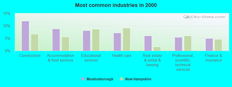
- Construction (11.9%)
- Accommodation & food services (8.8%)
- Educational services (8.1%)
- Health care (7.2%)
- Real estate & rental & leasing (6.1%)
- Professional, scientific, technical services (5.4%)
- Finance & insurance (5.1%)
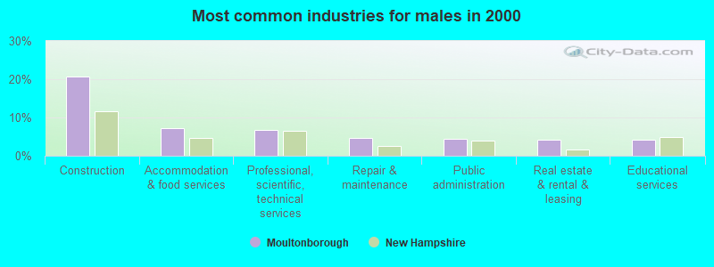
- Construction (20.7%)
- Accommodation & food services (7.3%)
- Professional, scientific, technical services (6.6%)
- Repair & maintenance (4.6%)
- Public administration (4.4%)
- Real estate & rental & leasing (4.2%)
- Educational services (4.2%)

- Educational services (12.6%)
- Health care (12.5%)
- Accommodation & food services (10.5%)
- Real estate & rental & leasing (8.2%)
- Finance & insurance (7.1%)
- Electronic shopping & mail-order houses (4.7%)
- Professional, scientific, technical services (4.1%)
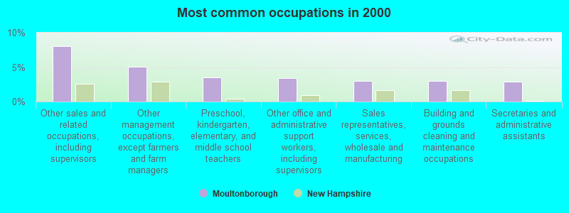
- Other sales and related occupations, including supervisors (8.0%)
- Other management occupations, except farmers and farm managers (5.0%)
- Preschool, kindergarten, elementary, and middle school teachers (3.5%)
- Other office and administrative support workers, including supervisors (3.4%)
- Sales representatives, services, wholesale and manufacturing (3.0%)
- Building and grounds cleaning and maintenance occupations (2.9%)
- Secretaries and administrative assistants (2.9%)
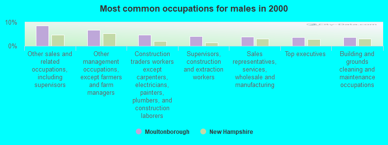
- Other sales and related occupations, including supervisors (8.6%)
- Other management occupations, except farmers and farm managers (6.6%)
- Construction traders workers except carpenters, electricians, painters, plumbers, and construction laborers (4.7%)
- Supervisors, construction and extraction workers (4.0%)
- Sales representatives, services, wholesale and manufacturing (3.9%)
- Top executives (3.7%)
- Building and grounds cleaning and maintenance occupations (3.7%)
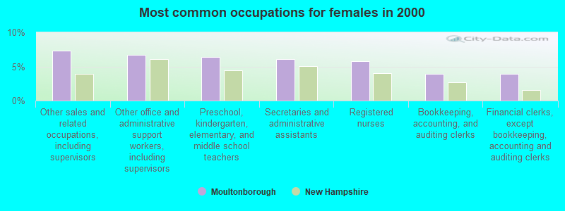
- Other sales and related occupations, including supervisors (7.3%)
- Other office and administrative support workers, including supervisors (6.7%)
- Preschool, kindergarten, elementary, and middle school teachers (6.3%)
- Secretaries and administrative assistants (6.1%)
- Registered nurses (5.8%)
- Bookkeeping, accounting, and auditing clerks (4.0%)
- Financial clerks, except bookkeeping, accounting and auditing clerks (4.0%)
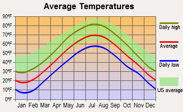
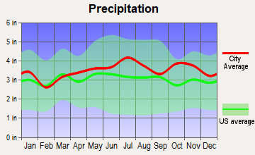
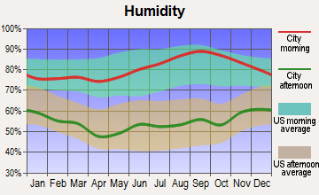
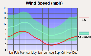
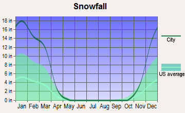
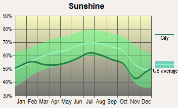
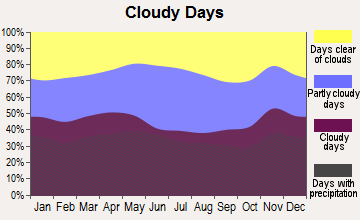
Average climate in Moultonborough, New Hampshire
Based on data reported by over 4,000 weather stations
(lower is better)
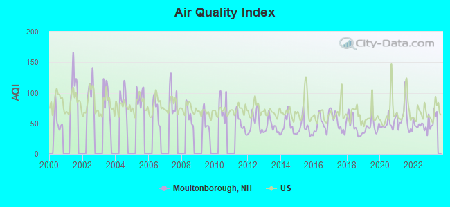
Air Quality Index (AQI) level in 2022 was 46.9. This is significantly better than average.
| City: | 46.9 |
| U.S.: | 72.6 |
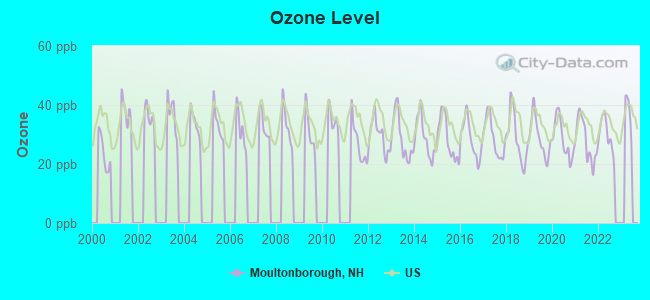
Ozone [ppb] level in 2022 was 29.9. This is about average. Closest monitor was 9.7 miles away from the city center.
| City: | 29.9 |
| U.S.: | 33.3 |
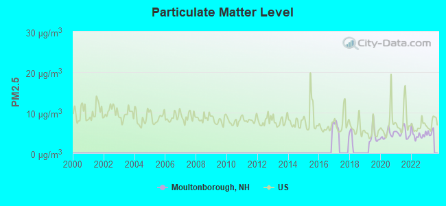
Particulate Matter (PM2.5) [µg/m3] level in 2022 was 4.52. This is significantly better than average. Closest monitor was 9.7 miles away from the city center.
| City: | 4.52 |
| U.S.: | 8.11 |
Tornado activity:
Moultonborough-area historical tornado activity is slightly below New Hampshire state average. It is 66% smaller than the overall U.S. average.
On 7/18/1963, a category F2 (max. wind speeds 113-157 mph) tornado 12.4 miles away from the Moultonborough town center caused between $5000 and $50,000 in damages.
On 7/3/1972, a category F2 tornado 20.3 miles away from the town center injured 7 people and caused between $5000 and $50,000 in damages.
Earthquake activity:
Moultonborough-area historical earthquake activity is significantly above New Hampshire state average. It is 72% smaller than the overall U.S. average.On 4/20/2002 at 10:50:47, a magnitude 5.3 (5.3 ML, Depth: 3.0 mi, Class: Moderate, Intensity: VI - VII) earthquake occurred 127.1 miles away from the city center
On 10/7/1983 at 10:18:46, a magnitude 5.3 (5.1 MB, 5.3 LG, 5.1 ML) earthquake occurred 148.1 miles away from the city center
On 1/19/1982 at 00:14:42, a magnitude 4.7 (4.5 MB, 4.7 MD, 4.5 LG, Class: Light, Intensity: IV - V) earthquake occurred 18.0 miles away from Moultonborough center
On 4/20/2002 at 10:50:47, a magnitude 5.2 (5.2 MB, 4.2 MS, 5.2 MW, 5.0 MW) earthquake occurred 127.3 miles away from Moultonborough center
On 10/16/2012 at 23:12:25, a magnitude 4.7 (4.7 ML, Depth: 10.0 mi) earthquake occurred 37.7 miles away from the city center
On 8/21/1996 at 07:54:14, a magnitude 3.8 (3.8 LG, 3.6 LG, Depth: 6.2 mi, Class: Light, Intensity: II - III) earthquake occurred 32.7 miles away from Moultonborough center
Magnitude types: regional Lg-wave magnitude (LG), body-wave magnitude (MB), duration magnitude (MD), local magnitude (ML), surface-wave magnitude (MS), moment magnitude (MW)
Natural disasters:
The number of natural disasters in Carroll County (29) is a lot greater than the US average (15).Major Disasters (Presidential) Declared: 17
Emergencies Declared: 9
Causes of natural disasters: Storms: 12, Floods: 11, Winter Storms: 5, Hurricanes: 4, Snows: 4, Snowstorms: 2, Blizzard: 1, Heavy Rain: 1, Ice Storm: 1, Snowfall: 1, Tornado: 1, Tropical Storm: 1, Wind: 1, Other: 1 (Note: some incidents may be assigned to more than one category).
Hospitals and medical centers in Moultonborough:
Other hospitals and medical centers near Moultonborough:
- BELKNAP COUNTY NURSING HOME (Nursing Home, about 13 miles away; LACONIA, NH)
- LACONIA CENTER, GENESIS HEALTHCARE (Nursing Home, about 13 miles away; LACONIA, NH)
- COMMUNITY HEALTH AND HOSPICE (Home Health Center, about 14 miles away; LACONIA, NH)
- CENTRAL NEW HAMPSHIRE KIDNEY CENTER (Dialysis Facility, about 14 miles away; LACONIA, NH)
- MOUNTAIN VIEW NURSING HOME (Nursing Home, about 14 miles away; OSSIPEE, NH)
- LAKES REGION GENERAL HOSPITAL Acute Care Hospitals (about 14 miles away; LACONIA, NH)
- HUGGINS HOSPITAL Critical Access Hospitals (about 14 miles away; WOLFEBORO, NH)
Heliports located in Moultonborough:
Colleges/universities with over 2000 students nearest to Moultonborough:
- Plymouth State University (about 16 miles; Plymouth, NH; Full-time enrollment: 4,838)
- NHTI-Concord's Community College (about 35 miles; Concord, NH; FT enrollment: 2,865)
- Dartmouth College (about 45 miles; Hanover, NH; FT enrollment: 6,030)
- Saint Joseph's College of Maine (about 47 miles; Standish, ME; FT enrollment: 2,010)
- University of New Hampshire-Main Campus (about 47 miles; Durham, NH; FT enrollment: 15,243)
- Southern New Hampshire University (about 47 miles; Manchester, NH; FT enrollment: 16,552)
- Saint Anselm College (about 51 miles; Manchester, NH; FT enrollment: 2,059)
Public high school in Moultonborough:
- MOULTONBOROUGH ACADEMY (Students: 235, Location: 25 BLAKE RD., Grades: 9-12)
Public elementary/middle school in Moultonborough:
- MOULTONBOROUGH ACADEMY (JUNIOR HIGH) (Students: 114, Location: 25 BLAKE RD., Grades: 7-8)
Points of interest:
Notable locations in Moultonborough: Bald Peak Colony Club (A), Arcadia Tent and Trailer Park (B), Bald Peak Colony Club (C), Jonathans Landing (D), Long Island Bridge Travel Trailer Park (E), Ossipee Mountain Ski Area (F), Red Hill Ski Touring Center (G), Moultonborough Fire Rescue Neck Station 2 (H), Moultonborough Fire Rescue Central Station (I). Display/hide their locations on the map
Church in Moultonborough: Moultonboro United Methodist Church (A). Display/hide its location on the map
Cemeteries: Lee Cemetery (1), Mason Cemetery (2), Red Hill Cemetery (3), Brown Cemetery (4), Shaw Cemetery (5), Shannon Cemetery (6), Bean Cemetery (7). Display/hide their locations on the map
Lakes and reservoirs: Lees Pond (A), Wakondah Pond (B), Berry Pond (C), Garland Pond (D), Center Harbor Sewage Lagoons Reservoir (E), Shannon Pond (F), Lake Kanasatka (G). Display/hide their locations on the map
Streams, rivers, and creeks: Halfway Brook (A), Red Hill River (B), South Brook (C), Shannon Brook (D), White Brook (E), Jackson Brook (F), Gulf Brook (G), Weed Brook (H). Display/hide their locations on the map
Park in Moultonborough: Kona Wildlife Area (1). Display/hide its location on the map
Beach: Moultonborough Town Beach (A). Display/hide its location on the map
Hotels: Berry Pond Motel (1040 Whittier Highway) (1), Rodeway Inn Moultonborough (Route 25 PO Box 366) (2). Display/hide their approximate locations on the map
Birthplace of: Wolfgang Moser - Olympic Rower.
Drinking water stations with addresses in Moultonborough and their reported violations in the past:
PARADISE SHORES (Population served: 1,881, Groundwater):Past health violations:LOV WATER (Population served: 538, Groundwater):Past monitoring violations:
- MCL, Monthly (TCR) - In OCT-2012, Contaminant: Coliform. Follow-up actions: St Public Notif requested (OCT-23-2012), St Violation/Reminder Notice (OCT-23-2012), St Public Notif received (OCT-25-2012), St Compliance achieved (APR-16-2013)
- MCL, Monthly (TCR) - In JUL-2012, Contaminant: Coliform. Follow-up actions: St Public Notif requested (JUL-20-2012), St Violation/Reminder Notice (JUL-20-2012), St Public Notif received (JUL-31-2012), St Formal NOV issued (AUG-27-2012), St Compliance achieved (APR-16-2013)
- MCL, Monthly (TCR) - In JUN-2012, Contaminant: Coliform. Follow-up actions: St Public Notif requested (JUN-12-2012), St Violation/Reminder Notice (JUN-12-2012), St Public Notif received (JUL-30-2012), St Formal NOV issued (AUG-27-2012), St Compliance achieved (APR-16-2013)
- MCL, Monthly (TCR) - In MAY-2010, Contaminant: Coliform. Follow-up actions: St Public Notif requested (MAY-05-2010), St Violation/Reminder Notice (MAY-05-2010), St Public Notif received (MAY-26-2010), St Compliance achieved (NOV-17-2010)
- MCL, Monthly (TCR) - In AUG-2007, Contaminant: Coliform. Follow-up actions: St Public Notif requested (AUG-10-2007), St Violation/Reminder Notice (AUG-10-2007), St Public Notif received (AUG-27-2007), St Compliance achieved (APR-07-2008)
- Monitoring, Source Water (GWR) - Between MAY-01-2010 and JUN-01-2010, Contaminant: E. COLI. Follow-up actions: St Violation/Reminder Notice (MAY-25-2010), St Compliance achieved (JUN-02-2010)
- One minor monitoring violation
Past monitoring violations:HIDDEN VALLEY/MASON (Population served: 253, Groundwater):
- 21 regular monitoring violations
Past health violations:INDIAN MOUND GOLF CLUB (Population served: 225, Groundwater):
- MCL, Acute (TCR) - In SEP-2011, Contaminant: Coliform. Follow-up actions: St Public Notif received (SEP-15-2011), St Public Notif requested (SEP-23-2011), St Violation/Reminder Notice (SEP-23-2011), St Compliance achieved (MAR-19-2012)
- MCL, Monthly (TCR) - In DEC-2010, Contaminant: Coliform. Follow-up actions: St Public Notif requested (DEC-21-2010), St Violation/Reminder Notice (DEC-21-2010), St Public Notif received (JAN-20-2011), St Compliance achieved (JUN-20-2011)
Past health violations:FAR ECHO HARBOR (Population served: 200, Groundwater):
- MCL, Monthly (TCR) - In SEP-2013, Contaminant: Coliform. Follow-up actions: St Public Notif requested (SEP-05-2013), St Violation/Reminder Notice (SEP-05-2013), St Public Notif received (SEP-12-2013), St Compliance achieved (APR-10-2014)
Past health violations:NORTH COUNTRY VILLAGE (Population served: 143, Groundwater):Past monitoring violations:
- MCL, Monthly (TCR) - In JUL-2012, Contaminant: Coliform. Follow-up actions: St Public Notif requested (JUL-30-2012), St Violation/Reminder Notice (JUL-30-2012), St Public Notif received (AUG-03-2012), St Compliance achieved (JAN-17-2013)
- MCL, Monthly (TCR) - In JUL-2011, Contaminant: Coliform. Follow-up actions: St Public Notif requested (JUL-14-2011), St Violation/Reminder Notice (JUL-14-2011), St Public Notif received (AUG-02-2011), St Compliance achieved (FEB-24-2012)
- OCCT/SOWT Study/Recommendation - In JUN-29-2011, Contaminant: Lead and Copper Rule. Follow-up actions: St Public Notif requested (JUL-05-2011), St Violation/Reminder Notice (JUL-05-2011), St Public Notif received (AUG-02-2011), St Compliance achieved (OCT-03-2011)
- OCCT/SOWT Study/Recommendation - In OCT-01-2010, Contaminant: Lead and Copper Rule. Follow-up actions: St Public Notif requested (OCT-14-2010), St Violation/Reminder Notice (OCT-14-2010), St Public Notif received (NOV-04-2010), St Compliance achieved (NOV-15-2010)
- MCL, Monthly (TCR) - In JUL-2010, Contaminant: Coliform. Follow-up actions: St Public Notif requested (JUL-19-2010), St Violation/Reminder Notice (JUL-19-2010), St Public Notif received (AUG-26-2010), St Compliance achieved (MAR-14-2011)
- Failure To Address Deficiency - In MAY-02-2013, Contaminant: GROUNDWATER RULE. Follow-up actions: St Violation/Reminder Notice (MAY-17-2013), St Compliance achieved (JUN-12-2013), St Intentional no-action (JUN-12-2013)
- One minor monitoring violation
Past health violations:DEER COVE WATER (Population served: 123, Groundwater):Past monitoring violations:
- MCL, Monthly (TCR) - In OCT-2012, Contaminant: Coliform. Follow-up actions: St Public Notif requested (OCT-23-2012), St Violation/Reminder Notice (OCT-23-2012), St Public Notif received (NOV-07-2012), St Compliance achieved (MAY-16-2013)
- MCL, Monthly (TCR) - In NOV-2006, Contaminant: Coliform. Follow-up actions: St Public Notif requested (DEC-19-2006), St Violation/Reminder Notice (DEC-19-2006), St Public Notif received (JAN-08-2007), St Compliance achieved (MAY-31-2007)
- MCL, Monthly (TCR) - In JUL-2006, Contaminant: Coliform. Follow-up actions: St Violation/Reminder Notice (AUG-02-2006), St Formal NOV issued (2 times from AUG-11-2006 to APR-24-2007), St Compliance achieved (MAY-31-2007)
- MCL, Monthly (TCR) - In JUN-2006, Contaminant: Coliform. Follow-up actions: St Public Notif requested (JUN-27-2006), St Violation/Reminder Notice (JUN-27-2006), St Public Notif received (JUL-05-2006), St Formal NOV issued (AUG-11-2006), St Compliance achieved (MAY-31-2007)
- Monitoring, Source Water (GWR) - Between JUL-01-2010 and AUG-01-2010, Contaminant: E. COLI. Follow-up actions: St Compliance achieved (JUL-20-2010), St Public Notif received (JUL-27-2010), St Public Notif requested (JUL-27-2010), St Violation/Reminder Notice (JUL-27-2010)
- Monitoring, Repeat Major (TCR) - Between JUL-2010 and SEP-2010, Contaminant: Coliform (TCR). Follow-up actions: St Public Notif requested (JUL-27-2010), St Violation/Reminder Notice (JUL-27-2010), St Compliance achieved (JUL-27-2010), St Public Notif received (AUG-06-2010)
- Monitoring, Repeat Major (TCR) - In OCT-2006, Contaminant: Coliform (TCR). Follow-up actions: St Violation/Reminder Notice (NOV-28-2006), St Compliance achieved (APR-16-2007), St Formal NOV issued (APR-24-2007)
Past health violations:RIDGEWOOD COUNTRY CLUB (Population served: 120, Groundwater):Past monitoring violations:
- OCCT/SOWT Study/Recommendation - In AUG-23-2013, Contaminant: Lead and Copper Rule. Follow-up actions: St Public Notif requested (SEP-18-2013), St Violation/Reminder Notice (SEP-18-2013), St Compliance achieved (SEP-23-2013), St Public Notif received (SEP-25-2013)
- Water Quality Parameter M/R - In JUL-01-2011, Contaminant: Lead and Copper Rule. Follow-up actions: St Public Notif requested (JAN-20-2012), St Violation/Reminder Notice (JAN-20-2012), St Public Notif received (MAR-19-2012), St Compliance achieved (MAR-22-2012)
- Follow-up Or Routine LCR Tap M/R - In JAN-01-2005, Contaminant: Lead and Copper Rule. Follow-up actions: St Public Notif requested (AUG-31-2005), St Violation/Reminder Notice (AUG-31-2005), St Compliance achieved (SEP-12-2005), St Public Notif received (SEP-12-2005)
Past monitoring violations:
- Monitoring, Source Water (GWR) - Between SEP-07-2012 and OCT-07-2012, Contaminant: E. COLI. Follow-up actions: St Public Notif requested (OCT-10-2012), St Violation/Reminder Notice (OCT-10-2012), St Compliance achieved (OCT-10-2012), St Public Notif received (OCT-16-2012)
- Monitoring, Repeat Major (TCR) - Between JUL-2012 and SEP-2012, Contaminant: Coliform (TCR). Follow-up actions: St Public Notif requested (OCT-10-2012), St Violation/Reminder Notice (OCT-10-2012), St Compliance achieved (OCT-10-2012), St Public Notif received (OCT-16-2012)
- 2 routine major monitoring violations
Drinking water stations with addresses in Moultonborough that have no violations reported:
- DEER RUN (Population served: 148, Primary Water Source Type: Groundwater)
- GUNSTOCK GLEN WATER (Population served: 138, Primary Water Source Type: Groundwater)
- PENDLETON COVE (Population served: 125, Primary Water Source Type: Groundwater)
- 175 ESTATES (Population served: 110, Primary Water Source Type: Groundwater)
- BRAKE HILL ACRES (Population served: 98, Primary Water Source Type: Groundwater)
| This town: | 2.3 people |
| New Hampshire: | 2.5 people |
| This town: | 71.3% |
| Whole state: | 66.3% |
| This town: | 5.5% |
| Whole state: | 8.3% |
Likely homosexual households (counted as self-reported same-sex unmarried-partner households)
- Lesbian couples: 0.6% of all households
- Gay men: 0.2% of all households
| This town: | 4.0% |
| Whole state: | 6.5% |
| This town: | 1.9% |
| Whole state: | 2.8% |
Banks with branches in Moultonborough (2011 data):
- Meredith Village Savings Bank: Moultonborough Corner Office at 991 State Route 25, branch established on 1996/01/22; Center Harbor/Moultonborough Office at 28 State Route 25, branch established on 1975/04/07. Info updated 2009/03/03: Bank assets: $669.2 mil, Deposits: $513.6 mil, headquarters in Meredith, NH, positive income, Commercial Lending Specialization, 13 total offices
- Laconia Savings Bank: Moultonborough Banking Branch at Route 25, branch established on 1996/03/18. Info updated 2009/02/12: Bank assets: $1,107.3 mil, Deposits: $876.1 mil, headquarters in Laconia, NH, positive income, Commercial Lending Specialization, 23 total offices, Holding Company: Lsb Financial
For population 15 years and over in Moultonborough:
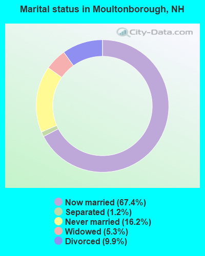
- Never married: 16.2%
- Now married: 67.4%
- Separated: 1.2%
- Widowed: 5.3%
- Divorced: 9.9%
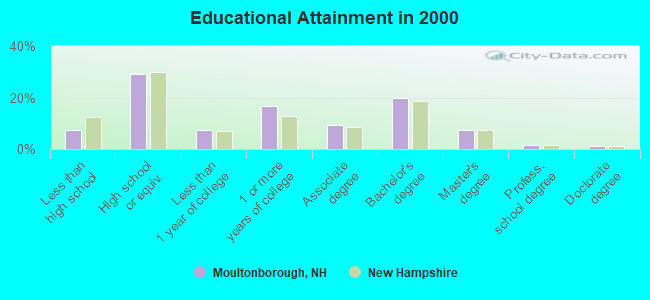
For population 25 years and over in Moultonborough:
- High school or higher: 92.5%
- Bachelor's degree or higher: 30.2%
- Graduate or professional degree: 10.2%
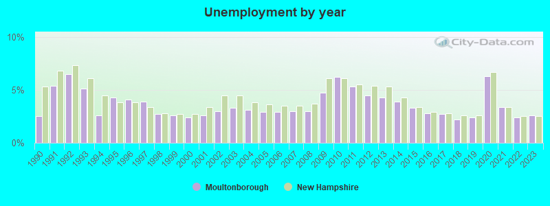
- Unemployed: 2.4%
- Mean travel time to work (commute): 32.0 minutes
| Here: | 9.5 |
| New Hampshire average: | 10.9 |
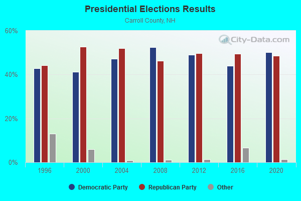
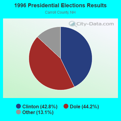
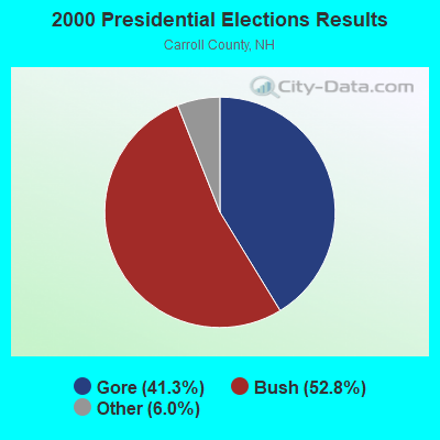

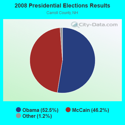
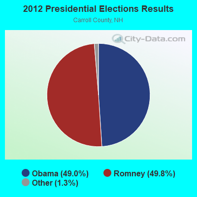

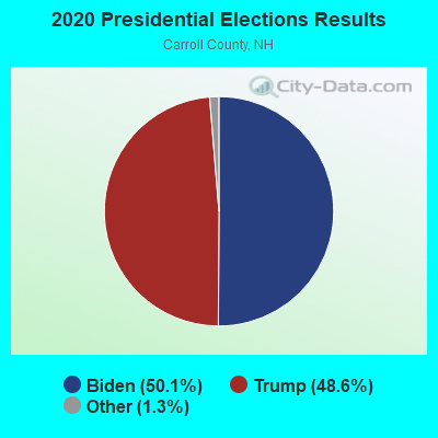
Graphs represent county-level data. Detailed 2008 Election Results
Political contributions by individuals in Moultonborough, NH
Religion statistics for Moultonborough, NH (based on Carroll County data)
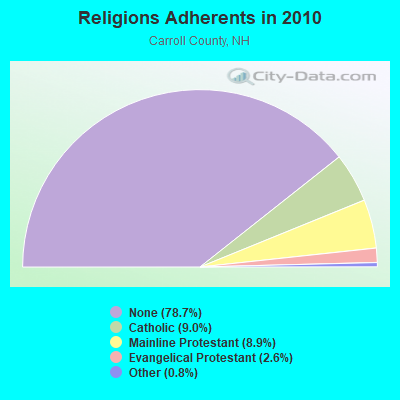
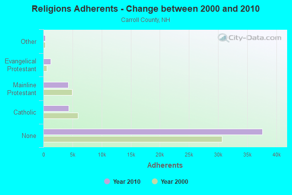
| Religion | Adherents | Congregations |
|---|---|---|
| Catholic | 4,304 | 2 |
| Mainline Protestant | 4,266 | 30 |
| Evangelical Protestant | 1,241 | 14 |
| Other | 366 | 5 |
| None | 37,641 | - |
Food Environment Statistics:
| Carroll County: | 4.23 / 10,000 pop. |
| State: | 2.14 / 10,000 pop. |
| This county: | 2.54 / 10,000 pop. |
| New Hampshire: | 1.78 / 10,000 pop. |
| This county: | 8.47 / 10,000 pop. |
| New Hampshire: | 4.02 / 10,000 pop. |
| This county: | 24.13 / 10,000 pop. |
| New Hampshire: | 9.70 / 10,000 pop. |
| Here: | 8.8% |
| New Hampshire: | 7.6% |
| Carroll County: | 21.2% |
| State: | 24.4% |
| Carroll County: | 16.9% |
| New Hampshire: | 15.9% |
| Businesses in Moultonborough, NH | ||||
| Name | Count | Name | Count | |
|---|---|---|---|---|
| Dunkin Donuts | 1 | Subway | 1 | |
| FedEx | 1 | U-Haul | 1 | |
| Rodeway Inn | 1 | UPS | 3 | |
Strongest AM radio stations in Moultonborough:
- WASR (1420 AM; 5 kW; WOLFEBORO, NH; Owner: RADIO WOLFEBORO, INC.)
- WEZS (1350 AM; 5 kW; LACONIA, NH; Owner: GARY W. HAMMOND)
- WPNH (1300 AM; 5 kW; PLYMOUTH, NH; Owner: NORTHEAST COMMUNICATIONS CORPORATION)
- WRKO (680 AM; 50 kW; BOSTON, MA; Owner: ENTERCOM BOSTON LICENSE, LLC)
- WGIN (930 AM; 10 kW; ROCHESTER, NH; Owner: CAPSTAR TX LIMITED PARTNERSHIP)
- WEEI (850 AM; 50 kW; BOSTON, MA; Owner: ENTERCOM BOSTON LICENSE, LLC)
- WMTW (870 AM; 10 kW; GORHAM, ME; Owner: RADIO PARTNERS OF MAINE, L.P.)
- WCRN (830 AM; 50 kW; WORCESTER, MA; Owner: CARTER BROADCASTING CORPORATION)
- WNNZ (640 AM; 50 kW; WESTFIELD, MA; Owner: CLEAR CHANNEL BROADCASTING LICENSES, INC.)
- WBZ (1030 AM; 50 kW; BOSTON, MA; Owner: INFINITY BROADCASTING OPERATIONS, INC.)
- WNTK (1020 AM; 10 kW; NEWPORT, NH; Owner: KOOR COMMUNICATIONS, INC.)
- WEMJ (1490 AM; 1 kW; LACONIA, NH; Owner: WLNH RADIO, INC.)
- WKOX (1200 AM; 50 kW; FRAMINGHAM, MA; Owner: CAPSTAR TX LIMITED PARTNERSHIP)
Strongest FM radio stations in Moultonborough:
- WSCY (106.9 FM; MOULTONBOROUGH, NH; Owner: NORTHEAST COMMUNICATIONS CORPORATION)
- WLKZ (104.9 FM; WOLFEBORO, NH; Owner: TELE-MEDIA COMPANY OF NEW HAMPSHIRE, L.L.C.)
- WVFM (105.7 FM; CAMPTON, NH; Owner: DEVON BROADCASTING COMPANY, INC.)
- WPKQ (103.7 FM; NORTH CONWAY, NH; Owner: CITADEL BROADCASTING COMPANY)
- WHOM (94.9 FM; MT. WASHINGTON, NH; Owner: CITADEL BROADCASTING COMPANY)
- WPNH-FM (100.1 FM; PLYMOUTH, NH; Owner: NORTHEAST COMMUNICATIONS CORPORATION)
- WLNH-FM (98.3 FM; LACONIA, NH; Owner: WLNH RADIO, INC)
- WMEA (90.1 FM; PORTLAND, ME; Owner: MAINE PUBLIC BROADCASTING CORPORATION)
- WBHG (101.5 FM; MEREDITH, NH; Owner: WLNH RADIO, INC)
- WNHI (93.3 FM; BELMONT, NH; Owner: CONCORD BROADCASTING, L.L.C.)
- WHDQ (106.1 FM; CLAREMONT, NH; Owner: GREAT NORTHERN RADIO, L.L.C.)
- WMEX (106.5 FM; FARMINGTON, NH; Owner: WIMMEX, LLC)
- WVPR (89.5 FM; WINDSOR, VT; Owner: VERMONT PUBLIC RADIO)
- WEVH (91.3 FM; HANOVER, NH; Owner: NEW HAMPSHIRE PUBLIC RADIO INC)
- WFTN-FM (94.1 FM; FRANKLIN, NH; Owner: NORTHEAST COMMUNICATIONS CORPORATION)
- WJJR (98.1 FM; RUTLAND, VT; Owner: 6 JOHNSON ROAD LICENSES, INC.)
- WZRT (97.1 FM; RUTLAND, VT; Owner: CAPSTAR TX LIMITED PARTNERSHIP)
- WBLM (102.9 FM; PORTLAND, ME; Owner: CITADEL BROADCASTING COMPANY)
- WGMT (97.7 FM; LYNDON, VT; Owner: VERMONT BROADCAST ASSOCIATES, INC.)
- WMWV (93.5 FM; CONWAY, NH; Owner: MT. WASHINGTON RADIO & GRAMOPHONE, L.L.C.)
TV broadcast stations around Moultonborough:
- WMTW-TV (Channel 8; POLAND SPRING, ME; Owner: WMTW BROADCAST GROUP, LLC)
- WMEA-TV (Channel 26; BIDDEFORD, ME; Owner: MAINE PUBLIC BROADCASTING CORP.)
- WCSH (Channel 6; PORTLAND, ME; Owner: PACIFIC AND SOUTHERN COMPANY, INC.)
- WGME-TV (Channel 13; PORTLAND, ME; Owner: WGME LICENSEE, LLC)
- National Bridge Inventory (NBI) Statistics
- 4Number of bridges
- 23ft / 7.1mTotal length
- $12,568,000Total costs
- 13,656Total average daily traffic
- 822Total average daily truck traffic
- 20,209Total future (year 2042) average daily traffic
FCC Registered Antenna Towers:
13 (See the full list of FCC Registered Antenna Towers in Moultonborough)FCC Registered Broadcast Land Mobile Towers:
1- Mount Faraway (Lat: 43.761750 Lon: -71.311472), Type: Tower, Structure height: 21 m, Call Sign: WPGP875,
Assigned Frequencies: 47.9000 MHz, Grant Date: 12/08/2004, Expiration Date: 02/21/2015, Cancellation Date: 02/04/2015, Registrant: New Hampshire Electric Cooperative, Inc., 579 Tenney Mtn Hwy, Plymouth, NH 03264, Phone: (603) 536-8811, Fax: (603) 536-8687, Email:
FCC Registered Microwave Towers:
2- STATION, Atop Peak In Western Ossipee Mountains (Lat: 43.769222 Lon: -71.313944), Overall height: 27.4 m, Call Sign: WNTL269,
Assigned Frequencies: 953.550 MHz, Grant Date: 08/23/2011, Expiration Date: 11/06/2021, Cancellation Date: 01/23/2014, Registrant: Northeast Communications Corporation, 110 Babbitt Road, Franklin, NH 03235, Phone: (603) 934-2500, Email:
- Rte 25 Harbor Mall (Lat: 43.708667 Lon: -71.457556), Overall height: 18.3 m, Call Sign: WLI932, Licensee ID: L00176823,
Assigned Frequencies: 946.000 MHz, Grant Date: 11/25/1991, Expiration Date: 04/01/2014, Cancellation Date: 01/23/2014, Registrant: Northeast Communications Corporation, P.O. Box 99, Franklin, NH 03235
FCC Registered Amateur Radio Licenses:
27 (See the full list of FCC Registered Amateur Radio Licenses in Moultonborough)FAA Registered Aircraft:
21 (See the full list of FAA Registered Aircraft in Moultonborough)2006 - 2018 National Fire Incident Reporting System (NFIRS) incidents
- Fire incident types reported to NFIRS in Moultonborough, NH
- 26857.0%Structure Fires
- 12827.2%Outside Fires
- 6012.8%Mobile Property/Vehicle Fires
- 143.0%Other
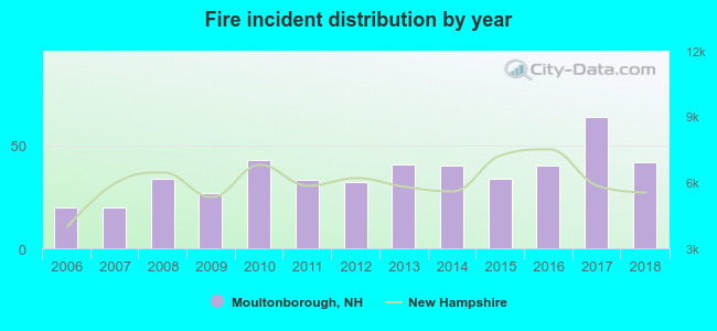 Based on the data from the years 2006 - 2018 the average number of fires per year is 36. The highest number of fire incidents - 64 took place in 2017, and the least - 20 in 2006. The data has a growing trend.
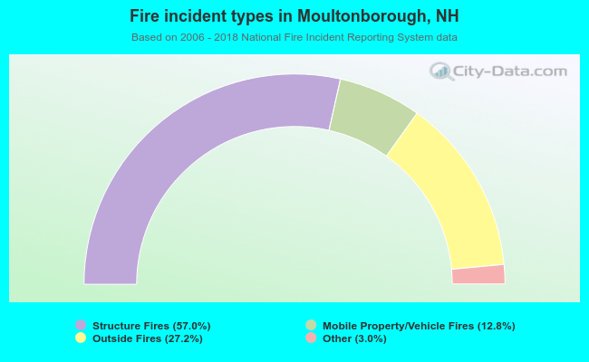 When looking into fire subcategories, the most incidents belonged to: Structure Fires (57.0%), and Outside Fires (27.2%).
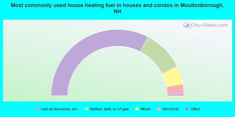
- 65.1%Fuel oil, kerosene, etc.
- 20.4%Bottled, tank, or LP gas
- 8.9%Wood
- 4.9%Electricity
- 0.3%No fuel used
- 0.2%Solar energy
- 0.1%Utility gas
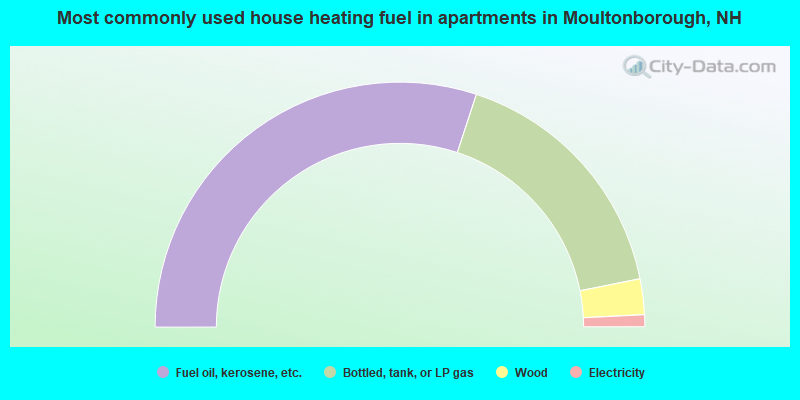
- 60.1%Fuel oil, kerosene, etc.
- 33.6%Bottled, tank, or LP gas
- 4.7%Wood
- 1.6%Electricity
Moultonborough compared to New Hampshire state average:
- Unemployed percentage significantly below state average.
- Black race population percentage significantly below state average.
- Hispanic race population percentage significantly below state average.
- Median age above state average.
- Foreign-born population percentage below state average.
- Renting percentage below state average.
- Length of stay since moving in significantly above state average.
- Number of rooms per house significantly below state average.
- House age significantly below state average.
- Number of college students below state average.

|
|
Total of 42 patent applications in 2008-2024.