Mount Herman, Kentucky
Submit your own pictures of this place and show them to the world
- OSM Map
- General Map
- Google Map
- MSN Map

| Males: 1,006 | |
| Females: 943 |
| Median resident age: | 37.0 years |
| Kentucky median age: | 35.9 years |
Zip code: 42167
| Mount Herman: | $55,469 |
| KY: | $59,341 |
Estimated per capita income in 2022: $22,497 (it was $12,006 in 2000)
Mount Herman CCD income, earnings, and wages data
Estimated median house or condo value in 2022: $131,508 (it was $58,300 in 2000)
| Mount Herman: | $131,508 |
| KY: | $196,300 |
Mean prices in 2022: all housing units: $196,388; detached houses: $189,157; townhouses or other attached units: $54,930; mobile homes: $249,571
Detailed information about poverty and poor residents in Mount Herman, KY


- 1,94098.8%White alone
- 150.8%Black alone
- 40.2%Two or more races
- 30.2%Hispanic
- 10.05%American Indian alone
- 10.05%Asian alone

Races in Mount Herman detailed stats: ancestries, foreign born residents, place of birth
 Recent articles from our blog. Our writers, many of them Ph.D. graduates or candidates, create easy-to-read articles on a wide variety of topics.
Current Local Time: CST time zone
Land area: 79.1 square miles.
Population density: 25 people per square mile (very low).

| Mount Herman CCD: | 0.6% ($328) |
| Kentucky: | 0.8% ($610) |
Nearest city with pop. 50,000+: Nashville-Davidson, TN  (71.6 miles , pop. 545,524).
Nearest city with pop. 1,000,000+: Chicago, IL (364.1 miles , pop. 2,896,016).
Nearest cities:
), ), ), Latitude: 36.79 N, Longitude: 85.75 W
Area code commonly used in this area: 270


| Here: | 4.1% |
| Kentucky: | 3.8% |

- Agriculture, forestry, fishing & hunting (15.5%)
- Wood products (10.2%)
- Health care (8.5%)
- Educational services (7.2%)
- Department & other general merchandise stores (6.4%)
- Metal & metal products (4.4%)
- Food & beverage stores (4.3%)

- Agriculture, forestry, fishing & hunting (23.7%)
- Wood products (14.5%)
- Metal & metal products (7.8%)
- Construction (5.5%)
- Transportation equipment (5.1%)
- Printing & related support activities (5.1%)
- Department & other general merchandise stores (4.9%)

- Health care (19.6%)
- Educational services (11.7%)
- Department & other general merchandise stores (8.4%)
- Accommodation & food services (7.4%)
- Apparel (5.9%)
- Agriculture, forestry, fishing & hunting (4.8%)
- Food & beverage stores (4.8%)

- Farmers and farm managers (10.5%)
- Other sales and related occupations, including supervisors (7.0%)
- Laborers and material movers, hand (6.2%)
- Other production occupations, including supervisors (5.8%)
- Metal workers and plastic workers (4.5%)
- Material recording, scheduling, dispatching, and distributing workers (3.7%)
- Other office and administrative support workers, including supervisors (3.2%)

- Farmers and farm managers (17.3%)
- Laborers and material movers, hand (11.0%)
- Other sales and related occupations, including supervisors (7.3%)
- Metal workers and plastic workers (7.1%)
- Other production occupations, including supervisors (6.7%)
- Carpenters (4.3%)
- Electrical equipment mechanics and other installation, maintenance, and repair workers, including supervisors (3.9%)

- Other sales and related occupations, including supervisors (6.6%)
- Registered nurses (5.9%)
- Other office and administrative support workers, including supervisors (5.6%)
- Cashiers (5.4%)
- Retail sales workers, except cashiers (5.1%)
- Bookkeeping, accounting, and auditing clerks (4.8%)
- Other production occupations, including supervisors (4.6%)
Average climate in Mount Herman, Kentucky
Based on data reported by over 4,000 weather stations


Tornado activity:
Mount Herman-area historical tornado activity is slightly above Kentucky state average. It is 51% greater than the overall U.S. average.
On 4/3/1974, a category F4 (max. wind speeds 207-260 mph) tornado 23.2 miles away from the Mount Herman place center killed 10 people and injured 113 people and caused between $5000 and $50,000 in damages.
On 4/27/1971, a category F4 tornado 29.7 miles away from the place center killed 6 people and injured 58 people.
Earthquake activity:
Mount Herman-area historical earthquake activity is significantly above Kentucky state average. It is 141% greater than the overall U.S. average.On 4/18/2008 at 09:36:59, a magnitude 5.4 (5.1 MB, 4.8 MS, 5.4 MW, 5.2 MW, Class: Moderate, Intensity: VI - VII) earthquake occurred 164.0 miles away from the city center
On 7/27/1980 at 18:52:21, a magnitude 5.2 (5.1 MB, 4.7 MS, 5.0 UK, 5.2 UK) earthquake occurred 139.2 miles away from the city center
On 4/18/2008 at 09:36:59, a magnitude 5.2 (5.2 MW, Depth: 8.9 mi) earthquake occurred 163.9 miles away from the city center
On 6/18/2002 at 17:37:15, a magnitude 5.0 (4.3 MB, 4.6 MW, 5.0 LG) earthquake occurred 138.9 miles away from Mount Herman center
On 6/10/1987 at 23:48:54, a magnitude 5.1 (4.9 MB, 4.4 MS, 4.6 MS, 5.1 LG) earthquake occurred 182.5 miles away from Mount Herman center
On 4/29/2003 at 08:59:39, a magnitude 4.9 (4.4 MB, 4.6 MW, 4.9 LG, Class: Light, Intensity: IV - V) earthquake occurred 159.1 miles away from Mount Herman center
Magnitude types: regional Lg-wave magnitude (LG), body-wave magnitude (MB), surface-wave magnitude (MS), moment magnitude (MW)
Natural disasters:
The number of natural disasters in Monroe County (13) is near the US average (15).Major Disasters (Presidential) Declared: 10
Emergencies Declared: 2
Causes of natural disasters: Storms: 9, Floods: 8, Tornadoes: 4, Mudslides: 2, Blizzard: 1, Freeze: 1, Hurricane: 1, Landslide: 1, Snow: 1, Snowfall: 1, Wind: 1, Winter Storm: 1, Other: 1 (Note: some incidents may be assigned to more than one category).
Hospitals and medical centers near Mount Herman:
Colleges/universities with over 2000 students nearest to Mount Herman:
- Lindsey Wilson College (about 33 miles; Columbia, KY; Full-time enrollment: 2,552)
- Western Kentucky University (about 42 miles; Bowling Green, KY; FT enrollment: 16,942)
- Southcentral Kentucky Community and Technical College (about 43 miles; Bowling Green, KY; FT enrollment: 2,794)
- Campbellsville University (about 45 miles; Campbellsville, KY; FT enrollment: 2,948)
- Tennessee Technological University (about 45 miles; Cookeville, TN; FT enrollment: 9,761)
- Volunteer State Community College (about 52 miles; Gallatin, TN; FT enrollment: 5,311)
- Elizabethtown Community and Technical College (about 64 miles; Elizabethtown, KY; FT enrollment: 3,762)
Points of interest:
Notable location: Mount Gilead (A). Display/hide its location on the map
Churches in Mount Herman include: White Church (A), New Salem Church (B), Oak Grove Church (C), Philippi Church (D), Pleasant Hill Church (E), Red Hill Church (F), Corinth Church (G), Skaggs Creek Church (H). Display/hide their locations on the map
Cemeteries: Biggers Cemetery (1), Tyree Cemetery (2), Payne Cemetery (3), McPherson Cemetery (4). Display/hide their locations on the map
Streams, rivers, and creeks: Dry Branch (A), Belcher Creek (B), Bethlehem Branch (C), Boyd Branch (D), Muncie Branch (E), Miller Branch (F), Goose Creek (G). Display/hide their locations on the map
| This place: | 2.6 people |
| Kentucky: | 2.5 people |
| This place: | 73.2% |
| Whole state: | 66.9% |
| This place: | 3.5% |
| Whole state: | 6.4% |
No gay or lesbian households reported
| This place: | 21.4% |
| Whole state: | 15.8% |
| This place: | 4.7% |
| Whole state: | 6.6% |
For population 15 years and over in Mount Herman:

- Never married: 21.0%
- Now married: 60.6%
- Separated: 0.7%
- Widowed: 7.3%
- Divorced: 11.1%
For population 25 years and over in Mount Herman:
- High school or higher: 61.7%
- Bachelor's degree or higher: 6.3%
- Graduate or professional degree: 2.3%
- Unemployed: 8.0%
- Mean travel time to work (commute): 24.0 minutes


| Here: | 14.7 |
| Kentucky average: | 13.8 |
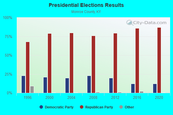
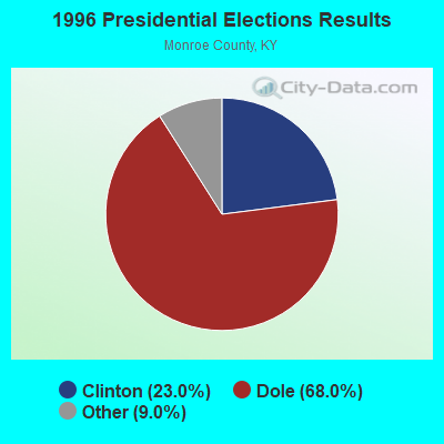
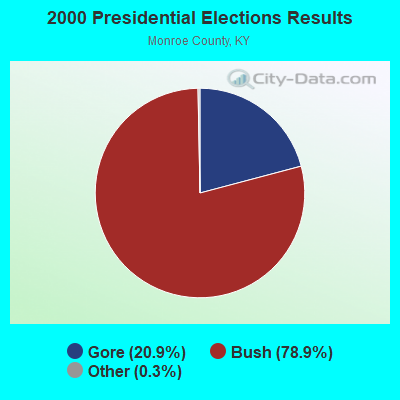

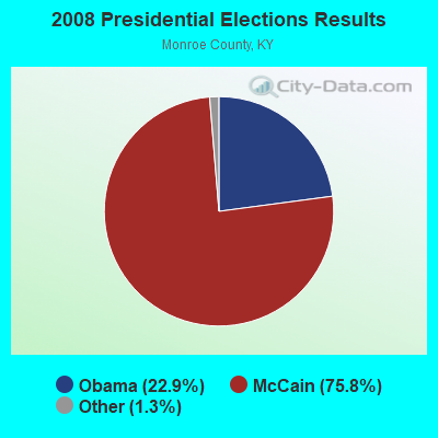
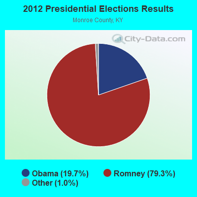

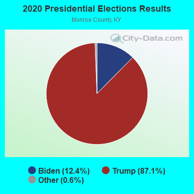
Graphs represent county-level data. Detailed 2008 Election Results
Religion statistics for Mount Herman, KY (based on Monroe County data)
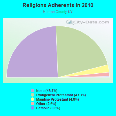

| Religion | Adherents | Congregations |
|---|---|---|
| Evangelical Protestant | 4,749 | 37 |
| Mainline Protestant | 522 | 6 |
| Other | 287 | 2 |
| Catholic | 64 | 1 |
| None | 5,341 | - |
Food Environment Statistics:
| This county: | 3.44 / 10,000 pop. |
| State: | 2.19 / 10,000 pop. |
| Here: | 0.86 / 10,000 pop. |
| Kentucky: | 0.25 / 10,000 pop. |
| This county: | 5.16 / 10,000 pop. |
| State: | 4.36 / 10,000 pop. |
| Monroe County: | 6.02 / 10,000 pop. |
| Kentucky: | 5.74 / 10,000 pop. |
| This county: | 10.9% |
| Kentucky: | 11.0% |
| This county: | 31.2% |
| Kentucky: | 30.0% |
| Monroe County: | 24.9% |
| Kentucky: | 15.9% |
Strongest AM radio stations in Mount Herman:
- WTKY (1370 AM; daytime; 2 kW; TOMPKINSVILLE, KY; Owner: WHITTIMORE ENTERPRISES, INC.)
- WSM (650 AM; 50 kW; NASHVILLE, TN; Owner: GAYLORD ENTERTAINMENT COMPANY)
- WAMB (1160 AM; 50 kW; DONELSON, TN; Owner: GREAT SOUTHERN BROADCASTING COMPANY, INC.)
- WLAC (1510 AM; 50 kW; NASHVILLE, TN; Owner: CAPSTAR TX LIMITED PARTNERSHIP)
- WKDA (1200 AM; 50 kW; NASHVILLE, TN; Owner: RADIO NASHVILLE, INC.)
- WNQM (1300 AM; 50 kW; NASHVILLE, TN; Owner: WNQM. INC.)
- WHAS (840 AM; 50 kW; LOUISVILLE, KY; Owner: CLEAR CHANNEL BROADCASTING LICENSES, INC.)
- WKVL (850 AM; daytime; 50 kW; KNOXVILLE, TN; Owner: HORNE RADIO, LLC)
- WWAM (820 AM; daytime; 50 kW; JASPER, TN; Owner: SHELTON BROADCASTING SYSTEM)
- WFLI (1070 AM; 50 kW; LOOKOUT MOUNTAIN, TN; Owner: WFLI, INC.)
- WKCT (930 AM; 5 kW; BOWLING GREEN, KY; Owner: DAILY NEWS BROADCASTING CO.)
- WPLN (1430 AM; 15 kW; MADISON, TN)
- WCLU (1490 AM; 1 kW; GLASGOW, KY; Owner: ROYSE RADIO, INC.)
Strongest FM radio stations in Mount Herman:
- WSGP (88.3 FM; GLASGOW, KY; Owner: SOMERSET EDUCATIONAL BROADCASTING FOUNDATION)
- WTKY-FM (92.1 FM; TOMPKINSVILLE, KY; Owner: WHITTIMORE ENTERPRISES, INC.)
- WOVO (105.3 FM; GLASGOW, KY; Owner: NEWBERRY BROADCASTING, INC.)
- WKWY (102.7 FM; TOMPKINSVILLE, KY; Owner: J.K. WHITTIMORE)
- WGGC (95.1 FM; GLASGOW, KY; Owner: HERITAGE COMMUNICATIONS, INC.)
- WGBV (94.1 FM; GLASGOW, KY; Owner: FOREVER COMMUNICATIONS,INC.)
- WGSQ (94.7 FM; COOKEVILLE, TN; Owner: CLEAR CHANNEL BROADCASTING LICENSES, INC.)
- WVFB (101.5 FM; CELINA, TN; Owner: ELIZABETH BERNICE WHITTIMORE)
- WLQK (95.9 FM; LIVINGSTON, TN; Owner: JWC BROADCASTING)
- WKNK (99.1 FM; EDMONTON, KY; Owner: HART COUNTY COMMUNICATIONS, INC.)
- WPTQ (103.7 FM; CAVE CITY, KY; Owner: NEWBERRY BROADCASTING, INC.)
- WHHT (106.7 FM; HORSE CAVE, KY; Owner: NEWBERRY BROADCASTING, INC.)
- WKYR-FM (107.9 FM; BURKESVILLE, KY; Owner: RAY MULLINIX)
- WBXE (93.7 FM; BAXTER, TN; Owner: JWC BROADCASTING)
- WDNS (93.3 FM; BOWLING GREEN, KY; Owner: DAILY NEWS BROADCASTING COMPANY)
- WLCT (102.1 FM; LAFAYETTE, TN; Owner: LAFAYETTE BROADCASTING CO., INC.)
- WVLE (99.3 FM; SCOTTSVILLE, KY; Owner: SHERANDAN BROADCASTING COMPANY, INC.)
- WCLU-FM (102.3 FM; MUNFORDVILLE, KY; Owner: ROYSE RADIO, INC)
TV broadcast stations around Mount Herman:
- WPBM-LP (Channel 48; SCOTTSVILLE, KY; Owner: PROCLAIM BROADCASTING, INC.)
- WPGD (Channel 50; HENDERSONVILLE, TN; Owner: TRINITY BROADCASTING NETWORK)
- WNKY (Channel 40; BOWLING GREEN, KY; Owner: MMK LICENSE LLC)

- 42.3%Electricity
- 31.3%Wood
- 17.9%Bottled, tank, or LP gas
- 4.6%Utility gas
- 3.8%Fuel oil, kerosene, etc.

- 52.5%Wood
- 32.4%Electricity
- 15.1%Bottled, tank, or LP gas
Mount Herman compared to Kentucky state average:
- Unemployed percentage below state average.
- Black race population percentage significantly below state average.
- Hispanic race population percentage significantly below state average.
- Foreign-born population percentage significantly below state average.
- Renting percentage below state average.
- Length of stay since moving in significantly above state average.
- Number of rooms per house significantly below state average.
- House age significantly below state average.
- Percentage of population with a bachelor's degree or higher significantly below state average.