Mount Herman Valley, Alabama
Submit your own pictures of this place and show them to the world
- OSM Map
- General Map
- Google Map
- MSN Map

| Males: 800 | |
| Females: 838 |
| Median resident age: | 36.5 years |
| Alabama median age: | 35.8 years |
Zip code: 36744
| Mount Herman Valley: | $46,404 |
| AL: | $59,674 |
Estimated per capita income in 2022: $28,562 (it was $15,069 in 2000)
Mount Herman Valley CCD income, earnings, and wages data
Estimated median house or condo value in 2022: $128,818 (it was $53,100 in 2000)
| Mount Herman Valley: | $128,818 |
| AL: | $200,900 |
Mean prices in 2022: all housing units: $187,223; detached houses: $234,385; townhouses or other attached units: $196,557; mobile homes: $116,649
Mount Herman Valley, AL residents, houses, and apartments details
Detailed information about poverty and poor residents in Mount Herman Valley, AL


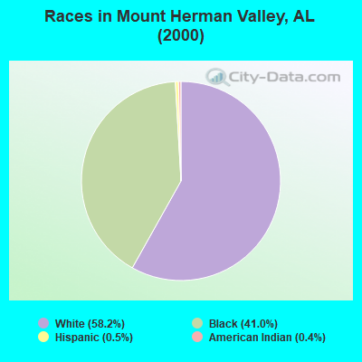
- 96358.2%White alone
- 67941.0%Black alone
- 80.5%Hispanic
- 60.4%American Indian alone
 Recent articles from our blog. Our writers, many of them Ph.D. graduates or candidates, create easy-to-read articles on a wide variety of topics.
Current Local Time: CST time zone
Land area: 111.3 square miles.
Population density: 15 people per square mile (very low).

| Mount Herman Valley CCD: | 0.4% ($199) |
| Alabama: | 0.4% ($289) |
Nearest city with pop. 50,000+: Tuscaloosa, AL  (28.9 miles , pop. 77,906).
Nearest city with pop. 200,000+: Birmingham, AL (65.1 miles , pop. 242,820).
Nearest city with pop. 1,000,000+: Houston, TX (510.0 miles , pop. 1,953,631).
Nearest cities:
), ), ), ), ), ), )Latitude: 32.79 N, Longitude: 87.51 W
Area code commonly used in this area: 334

| Here: | 3.5% |
| Alabama: | 2.6% |
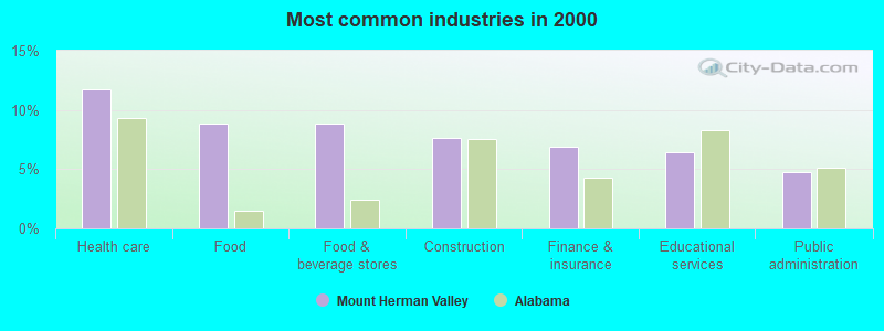
- Health care (11.7%)
- Food (8.8%)
- Food & beverage stores (8.8%)
- Construction (7.6%)
- Finance & insurance (6.9%)
- Educational services (6.4%)
- Public administration (4.8%)
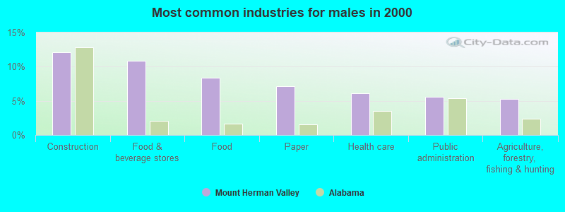
- Construction (12.2%)
- Food & beverage stores (10.9%)
- Food (8.4%)
- Paper (7.1%)
- Health care (6.1%)
- Public administration (5.6%)
- Agriculture, forestry, fishing & hunting (5.3%)
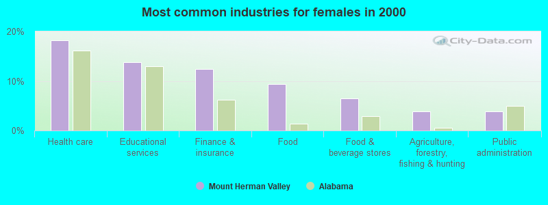
- Health care (18.2%)
- Educational services (13.8%)
- Finance & insurance (12.4%)
- Food (9.4%)
- Food & beverage stores (6.5%)
- Agriculture, forestry, fishing & hunting (3.8%)
- Public administration (3.8%)
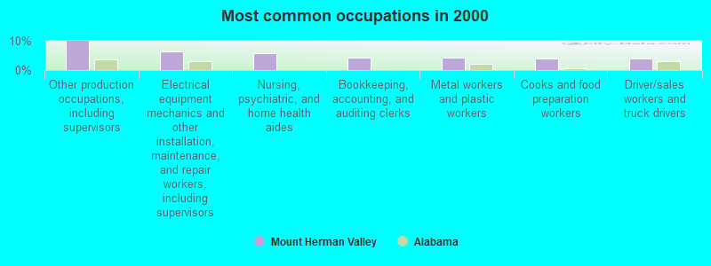
- Other production occupations, including supervisors (9.9%)
- Electrical equipment mechanics and other installation, maintenance, and repair workers, including supervisors (6.3%)
- Nursing, psychiatric, and home health aides (5.7%)
- Bookkeeping, accounting, and auditing clerks (4.4%)
- Metal workers and plastic workers (4.2%)
- Cooks and food preparation workers (4.1%)
- Driver/sales workers and truck drivers (4.1%)
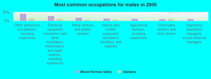
- Other production occupations, including supervisors (16.7%)
- Electrical equipment mechanics and other installation, maintenance, and repair workers, including supervisors (11.6%)
- Metal workers and plastic workers (7.8%)
- Vehicle and mobile equipment mechanics, installers, and repairers (6.1%)
- Agricultural workers, including supervisors (5.3%)
- Driver/sales workers and truck drivers (4.8%)
- Operations specialties managers, except financial managers (4.6%)
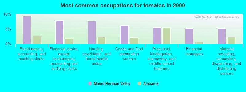
- Bookkeeping, accounting, and auditing clerks (9.4%)
- Financial clerks, except bookkeeping, accounting and auditing clerks (7.9%)
- Nursing, psychiatric, and home health aides (7.6%)
- Cooks and food preparation workers (6.2%)
- Preschool, kindergarten, elementary, and middle school teachers (5.6%)
- Financial managers (5.3%)
- Material recording, scheduling, dispatching, and distributing workers (5.3%)
Average climate in Mount Herman Valley, Alabama
Based on data reported by over 4,000 weather stations


(lower is better)
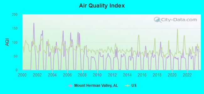
Air Quality Index (AQI) level in 2022 was 53.7. This is better than average.
| City: | 53.7 |
| U.S.: | 72.6 |
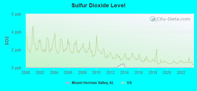
Sulfur Dioxide (SO2) [ppb] level in 2013 was 0.310. This is significantly better than average. Closest monitor was 21.0 miles away from the city center.
| City: | 0.310 |
| U.S.: | 1.515 |
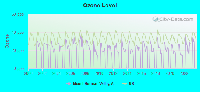
Ozone [ppb] level in 2022 was 26.2. This is better than average. Closest monitor was 21.0 miles away from the city center.
| City: | 26.2 |
| U.S.: | 33.3 |
Tornado activity:
Mount Herman Valley-area historical tornado activity is slightly below Alabama state average. It is 68% greater than the overall U.S. average.
On 2/23/1975, a category F4 (max. wind speeds 207-260 mph) tornado 20.8 miles away from the Mount Herman Valley place center killed one person and injured 49 people and caused between $5,000,000 and $50,000,000 in damages.
On 12/16/2000, a category F4 tornado 21.1 miles away from the place center killed 11 people and injured 144 people and caused $12 million in damages.
Earthquake activity:
Mount Herman Valley-area historical earthquake activity is significantly above Alabama state average. It is 125% greater than the overall U.S. average.On 1/18/1999 at 07:00:53, a magnitude 4.8 (4.8 MB, 4.0 LG, Depth: 0.6 mi, Class: Light, Intensity: IV - V) earthquake occurred 45.2 miles away from the city center
On 10/24/1997 at 08:35:17, a magnitude 4.9 (4.8 MB, 4.2 MS, 4.9 LG, Depth: 6.2 mi) earthquake occurred 116.1 miles away from the city center
On 6/24/1975 at 11:11:36, a magnitude 4.5 (4.5 MB) earthquake occurred 67.1 miles away from Mount Herman Valley center
On 11/7/2004 at 11:20:21, a magnitude 4.3 (4.3 MW, Depth: 3.1 mi) earthquake occurred 26.3 miles away from the city center
On 4/29/2003 at 08:59:39, a magnitude 4.9 (4.4 MB, 4.6 MW, 4.9 LG) earthquake occurred 160.2 miles away from the city center
On 4/29/2003 at 08:59:39, a magnitude 4.6 (4.6 MW, Depth: 12.3 mi) earthquake occurred 160.2 miles away from the city center
Magnitude types: regional Lg-wave magnitude (LG), body-wave magnitude (MB), surface-wave magnitude (MS), moment magnitude (MW)
Natural disasters:
The number of natural disasters in Hale County (16) is near the US average (15).Major Disasters (Presidential) Declared: 9
Emergencies Declared: 5
Causes of natural disasters: Hurricanes: 6, Storms: 6, Floods: 5, Tornadoes: 5, Winds: 3, Drought: 1, Snowfall: 1, Winter Storm: 1, Other: 1 (Note: some incidents may be assigned to more than one category).
Colleges/universities with over 2000 students nearest to Mount Herman Valley:
- Shelton State Community College (about 24 miles; Tuscaloosa, AL; Full-time enrollment: 4,106)
- The University of Alabama (about 30 miles; Tuscaloosa, AL; FT enrollment: 30,931)
- University of West Alabama (about 42 miles; Livingston, AL; FT enrollment: 3,394)
- University of Montevallo (about 44 miles; Montevallo, AL; FT enrollment: 2,826)
- East Mississippi Community College (about 57 miles; Scooba, MS; FT enrollment: 5,180)
- Lawson State Community College-Birmingham Campus (about 59 miles; Birmingham, AL; FT enrollment: 2,695)
- Virginia College-Birmingham (about 62 miles; Birmingham, AL; FT enrollment: 8,167)
Points of interest:
Notable location: Friendship Volunteer Fire Department (A). Display/hide its location on the map
Churches in Mount Herman Valley include: Bethel Church (A), Pleasant Grove Church (B), Saint Thomas Church (C), Union Grove Church (D), Spring Hill Church (E), Saint John Church (F), Pleasant Valley Church (G), Mount Herman Church (H), Friendship Church (I). Display/hide their locations on the map
Cemeteries: Weaver Cemetery (1), Terrell Cemetery (2), Whitsitt-Perry Cemetery (3), Union Grove Cemetery (4), Saint Johns Cemetery (5), Rhodes Chapel Cemetery (6), Pruitt Springs Cemetery (7). Display/hide their locations on the map
Reservoirs: Murphy Averette Lake (A), Lenson Montgomery Lake Number 2 (B), Lenson Montgomery Lake Number 1 (C), J B Thomas Lake (D), Thomas Lake (E), Joe Glover Lake (F), Montz Lake Number Four (G), Lenson Montz Ponds (H). Display/hide their locations on the map
Streams, rivers, and creeks: Polecat Creek (A), Sparks Creek (B), Bills Branch (C), Brush Creek (D). Display/hide their locations on the map
| This place: | 2.5 people |
| Alabama: | 2.5 people |
| This place: | 72.1% |
| Whole state: | 70.4% |
| This place: | 1.7% |
| Whole state: | 3.4% |
Likely homosexual households (counted as self-reported same-sex unmarried-partner households)
- Lesbian couples: 0.2% of all households
- Gay men: 0.2% of all households
| This place: | 18.6% |
| Whole state: | 16.1% |
| This place: | 6.7% |
| Whole state: | 7.3% |
For population 15 years and over in Mount Herman Valley:
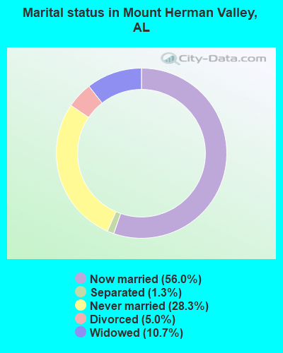
- Never married: 28.3%
- Now married: 56.0%
- Separated: 1.3%
- Widowed: 10.7%
- Divorced: 5.0%
For population 25 years and over in Mount Herman Valley:
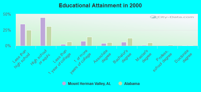
- High school or higher: 65.6%
- Bachelor's degree or higher: 7.7%
- Graduate or professional degree: 1.8%
- Unemployed: 7.1%
- Mean travel time to work (commute): 24.4 minutes
| Here: | 13.1 |
| Alabama average: | 13.2 |
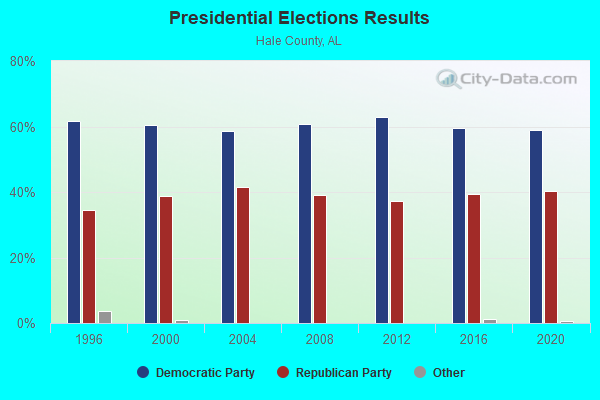
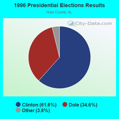
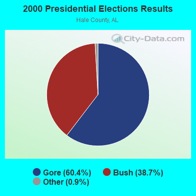
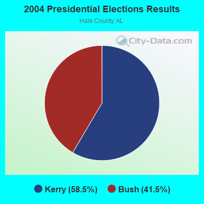
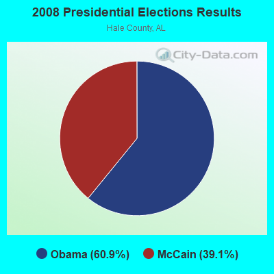

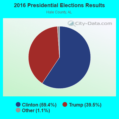

Graphs represent county-level data. Detailed 2008 Election Results
Religion statistics for Mount Herman Valley, AL (based on Hale County data)
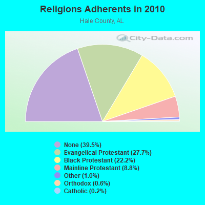
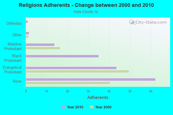
| Religion | Adherents | Congregations |
|---|---|---|
| Evangelical Protestant | 4,362 | 25 |
| Black Protestant | 3,493 | 24 |
| Mainline Protestant | 1,386 | 16 |
| Other | 165 | 2 |
| Orthodox | 100 | 1 |
| Catholic | 25 | 1 |
| None | 6,229 | - |
Food Environment Statistics:
| Hale County: | 2.77 / 10,000 pop. |
| Alabama: | 1.89 / 10,000 pop. |
| Here: | 1.11 / 10,000 pop. |
| Alabama: | 0.65 / 10,000 pop. |
| This county: | 7.74 / 10,000 pop. |
| Alabama: | 6.32 / 10,000 pop. |
| Here: | 3.87 / 10,000 pop. |
| Alabama: | 5.75 / 10,000 pop. |
| Here: | 14.4% |
| State: | 11.8% |
| Hale County: | 38.6% |
| State: | 31.7% |
| Hale County: | 7.5% |
| State: | 13.5% |
Strongest AM radio stations in Mount Herman Valley:
- WJOX (690 AM; 50 kW; BIRMINGHAM, AL; Owner: CITADEL BROADCASTING COMPANY)
- WJUS (1310 AM; 5 kW; MARION, AL; Owner: GRACE BAPTIST TEMPLE CHURCH)
- WAPI (1070 AM; 50 kW; BIRMINGHAM, AL; Owner: CITADEL BROADCASTING COMPANY)
- WDJC (850 AM; 50 kW; BIRMINGHAM, AL; Owner: KIMTRON, INC.)
- WTSK (790 AM; 5 kW; TUSCALOOSA, AL; Owner: APEX BROADCASTING INC.)
- WACT (1420 AM; 5 kW; TUSCALOOSA, AL; Owner: CAPSTAR TX LIMITED PARTNERSHIP)
- WWPG (1280 AM; 5 kW; TUSCALOOSA, AL; Owner: LAWSON OF TUSCALOOSA, INC.)
- WSPZ (1150 AM; 5 kW; TUSCALOOSA, AL; Owner: RADIO SOUTH, INC)
- WNSI (810 AM; 50 kW; JACKSONVILLE, AL; Owner: UNITED BROADCASTING NETWORK, INC.)
- WCPC (940 AM; 50 kW; HOUSTON, MS; Owner: WCPC BROADCASTING CO., INC.)
- WYLS (670 AM; daytime; 5 kW; YORK, AL; Owner: GRANTELL BROADCASTING COMPANY)
- WSJC (810 AM; 50 kW; MAGEE, MS; Owner: FAMILY TALK RADIO)
- WASG (550 AM; 25 kW; ATMORE, AL; Owner: 550 AM, INC)
Strongest FM radio stations in Mount Herman Valley:
- WDGM (99.1 FM; GREENSBORO, AL; Owner: WARRIOR BROADCASTING INC.)
- WTUG-FM (92.9 FM; TUSCALOOSA, AL; Owner: APEX BROADCASTING INC.)
- WBHJ (95.7 FM; TUSCALOOSA, AL; Owner: CXR HOLDINGS, INC.)
- WANZ (100.7 FM; NORTHPORT, AL; Owner: APEX BRAODCASTING INC.)
- WDXB (102.5 FM; JASPER, AL; Owner: CAPSTAR TX LIMITED PARTNERSHIP)
- WQZZ (104.3 FM; EUTAW, AL; Owner: JIM LAWSON COMMUNICATIONS, INC.)
- WUAL-FM (91.5 FM; TUSCALOOSA, AL; Owner: UNIVERSITY OF ALABAMA)
- WNPT-FM (102.9 FM; LINDEN, AL; Owner: BECKHAM PALMER III AS RECEIVER)
- WTXT (98.1 FM; FAYETTE, AL; Owner: CAPSTAR TX LIMITED PARTNERSHIP)
- WZNJ (106.5 FM; DEMOPOLIS, AL; Owner: ROSS COMMUNICATIONS, INC.)
- WVFG (107.5 FM; UNIONTOWN, AL; Owner: CHARLES E. JONES, JR.)
- W247AN (97.3 FM; TUSCALOOSA, AL; Owner: WILLIAM PAXTON ROGERS)
TV broadcast stations around Mount Herman Valley:
- WDVZ-CA (Channel 3; GREENSBORO, AL; Owner: TTI, INC.)
- WJMY-CA (Channel 28; DEMOPOLIS, AL; Owner: TTI, INC.)
- WLDM (Channel 23; TUSCALOOSA, AL; Owner: CHANNEL 23, LLC)
- W46BU (Channel 46; TUSCALOOSA, AL; Owner: TRINITY BROADCASTING NETWORK)
- WCFT-TV (Channel 33; TUSCALOOSA, AL; Owner: TV ALABAMA, INCORPORATED)
- WDBB (Channel 17; BESSEMER, AL; Owner: WDBB-TV, INC.)
- WBIH (Channel 29; SELMA, AL; Owner: FLINN BROADCASTING CORPORATION)
- WIIQ (Channel 41; DEMOPOLIS, AL; Owner: ALABAMA EDUCATIONAL TELEVISION COMMISSION)
- WVUA-CA (Channel 7; TUSCALOOSA/NORTHPORT, AL; Owner: THE BOARD OF TRUSTEES OF THE UNIVERSITY OF ALABAMA)
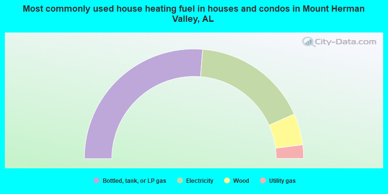
- 52.5%Bottled, tank, or LP gas
- 34.1%Electricity
- 9.3%Wood
- 4.0%Utility gas
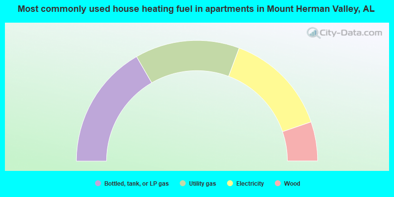
- 33.3%Bottled, tank, or LP gas
- 28.1%Utility gas
- 28.1%Electricity
- 10.5%Wood
Mount Herman Valley compared to Alabama state average:
- Median house value below state average.
- Unemployed percentage below state average.
- Hispanic race population percentage significantly below state average.
- Median age below state average.
- Foreign-born population percentage significantly below state average.
- Renting percentage significantly below state average.
- Length of stay since moving in significantly above state average.
- Number of rooms per house significantly below state average.
- House age significantly below state average.
- Number of college students below state average.
- Percentage of population with a bachelor's degree or higher significantly below state average.