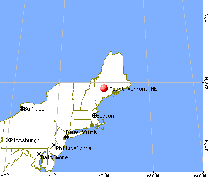
Mount Vernon, Maine

Mount Vernon: kent Hill in the Fall 2

Mount Vernon: kent Hill in the Fall

Mount Vernon: tree in our woods

Mount Vernon: flowers in my moms garden
- add
your
Submit your own pictures of this town and show them to the world
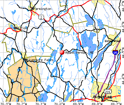
- OSM Map
- General Map
- Google Map
- MSN Map
Population change since 2000: +7.6%
 |
| Males: 809 | |
| Females: 831 |
| Median resident age: | 45.7 years |
| Maine median age: | 43.0 years |
Zip codes: 04352.
| Mount Vernon: | $68,601 |
| ME: | $69,543 |
Estimated per capita income in 2022: $39,490 (it was $19,668 in 2000)
Mount Vernon town income, earnings, and wages data
Estimated median house or condo value in 2022: $238,415 (it was $87,700 in 2000)
| Mount Vernon: | $238,415 |
| ME: | $290,600 |
Mean prices in 2022: all housing units: $236,573; detached houses: $257,878; townhouses or other attached units: $279,624; in 2-unit structures: $165,218; in 3-to-4-unit structures: $152,679; in 5-or-more-unit structures: $182,239; mobile homes: $91,490
Detailed information about poverty and poor residents in Mount Vernon, ME
Compare current foreclosures near Mount Vernon, ME:
| Photo | Address | Area | Beds / Baths | Price | Details |
|---|---|---|---|---|---|

|
#1
Dr Mann Rd
Augusta, ME 04330
|
1,320 sq. feet
|
2 baths 2 beds |
$315,000
|
show details |

|
#2
Hubbard St
Oakland, ME 04963
|
1,126 sq. feet
|
1 baths 1 beds |
$219,900
|
show details |

|
#3
Riverside Dr
Vassalboro, ME 04989
|
1,510 sq. feet
|
2 baths 4 beds |
$364,900
|
show details |

|
#4
Washington St
Augusta, ME 04330
|
1,478 sq. feet
|
2 baths 3 beds |
$77,050
|
show details |

|
#5
Knapp St
Wilton, ME 04294
|
- sq. feet
|
2 baths 4 beds |
show details | |

|
#6
Highland Heights Rd
Winthrop, ME 04364
|
1,800 sq. feet
|
1 baths 4 beds |
show details | |

|
#7
W River Rd
Augusta, ME 04330
|
1,440 sq. feet
|
2 baths 4 beds |
show details | |

|
#8
Longwood Ave
Augusta, ME 04330
|
1,274 sq. feet
|
1 baths 3 beds |
show details | |

|
#9
Western Ave
Waterville, ME 04901
|
2,808 sq. feet
|
3 baths 5 beds |
show details | |

|
#10
Riverside Dr
Augusta, ME 04330
|
1,724 sq. feet
|
2 baths 3 beds |
show details |
| Photo | Address | Area | Beds / Baths | Price | Details |
|---|---|---|---|---|---|

|
#11
Rice Rips Rd
Oakland, ME 04963
|
- sq. feet
|
- baths - beds |
show details | |

|
#12
Church Hill Rd
Augusta, ME 04330
|
- sq. feet
|
- baths - beds |
show details | |

|
#13
Row House Ln
Hallowell, ME 04347
|
- sq. feet
|
- baths - beds |
show details | |

|
#14
Crestwood Dr, Apt 4k
Waterville, ME 04901
|
- sq. feet
|
- baths - beds |
show details | |

|
#15
Morrison Ave Apt 2
Waterville, ME 04901
|
- sq. feet
|
- baths - beds |
show details | |

|
#16
Farrington Rd
Jay, ME 04239
|
- sq. feet
|
- baths - beds |
show details | |

|
#17
Bangor St
Augusta, ME 04330
|
- sq. feet
|
- baths - beds |
show details | |

|
#18
Perham St Apt 13
Farmington, ME 04938
|
- sq. feet
|
- baths - beds |
show details | |

|
#19
Pleasant St # 2
Augusta, ME 04330
|
- sq. feet
|
- baths - beds |
show details | |

|
#20
Meadow Rd Apt 204
Augusta, ME 04330
|
- sq. feet
|
- baths - beds |
show details |
| Photo | Address | Area | Beds / Baths | Price | Details |
|---|---|---|---|---|---|

|
#21
Powell Ave Apt 5
Oakland, ME 04963
|
- sq. feet
|
- baths - beds |
show details | |

|
#22
Prescott Rd
Manchester, ME 04351
|
1,440 sq. feet
|
- baths - beds |
show details | |

|
#23
Gleason Farm Rd
Oakland, ME 04963
|
- sq. feet
|
- baths - beds |
show details | |

|
#24
Jesse Ladd Rd
Vienna, ME 04360
|
- sq. feet
|
- baths - beds |
show details | |

|
#25
Chesterville Rd
Jay, ME 04239
|
- sq. feet
|
- baths - beds |
show details | |

|
#26
Hill St
Oakland, ME 04963
|
- sq. feet
|
- baths - beds |
show details | |

|
#27
Axtell Dr
Oakland, ME 04963
|
- sq. feet
|
- baths - beds |
show details | |

|
#28
Bouchard Dr
Belgrade, ME 04917
|
- sq. feet
|
- baths - beds |
show details | |

|
#29
Meadow Brook Dr
Belgrade, ME 04917
|
- sq. feet
|
- baths - beds |
show details | |

|
Check over 1 million property listings on Foreclosure.com!
|
browse all offers | |||

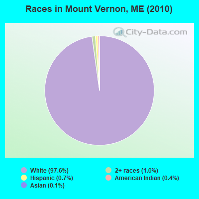
- 1,60197.6%White alone
- 171.0%Two or more races
- 120.7%Hispanic
- 60.4%American Indian alone
- 20.1%Asian alone
- 10.06%Black alone
- 10.06%Other race alone
Races in Mount Vernon detailed stats: ancestries, foreign born residents, place of birth
According to our research of Maine and other state lists, there were 2 registered sex offenders living in Mount Vernon, Maine as of May 19, 2024.
The ratio of all residents to sex offenders in Mount Vernon is 820 to 1.
The ratio of registered sex offenders to all residents in this city is lower than the state average.
 Recent articles from our blog. Our writers, many of them Ph.D. graduates or candidates, create easy-to-read articles on a wide variety of topics.

 | upstate NY vs Maine (14 replies) |
| Thoughts on Mount Vernon? (4 replies) |
| Monmouth vs. Readfield (7 replies) |
| Maine-grown wheat? (13 replies) |
| Buying and building in Maine. (51 replies) |
| building in maine (37 replies) |
Latest news from Mount Vernon, ME collected exclusively by city-data.com from local newspapers, TV, and radio stations
Ancestries: English (20.9%), United States (15.8%), Irish (10.5%), German (10.1%), French (9.9%), French Canadian (5.4%).
Current Local Time: EST time zone
Incorporated on 06/28/1792
Elevation: 339 feet
Land area: 37.9 square miles.
Population density: 43 people per square mile (very low).
25 residents are foreign born
| This town: | 1.6% |
| Maine: | 2.9% |
| Mount Vernon town: | 1.5% ($1,282) |
| Maine: | 1.5% ($1,417) |
Nearest city with pop. 50,000+: Portland, ME  (57.5 miles , pop. 64,249).
Nearest city with pop. 200,000+: Boston, MA (158.8 miles , pop. 589,141).
Nearest city with pop. 1,000,000+: Bronx, NY (319.7 miles , pop. 1,332,650).
Nearest cities:
), ), ), )Latitude: 44.47 N, Longitude: 69.96 W
Area code: 207

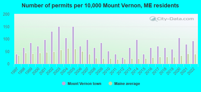
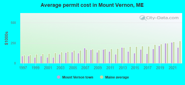
Single-family new house construction building permits:
- 2022: 14 buildings, average cost: $198,200
- 2021: 12 buildings, average cost: $259,200
- 2020: 16 buildings, average cost: $248,200
- 2019: 9 buildings, average cost: $219,400
- 2018: 10 buildings, average cost: $177,500
- 2017: 11 buildings, average cost: $119,100
- 2016: 10 buildings, average cost: $171,100
- 2015: 6 buildings, average cost: $124,700
- 2014: 15 buildings, average cost: $147,300
- 2013: 10 buildings, average cost: $195,000
- 2012: 4 buildings, average cost: $113,800
- 2011: 6 buildings, average cost: $146,000
- 2010: 8 buildings, average cost: $171,500
- 2009: 13 buildings, average cost: $137,600
- 2008: 10 buildings, average cost: $167,500
- 2007: 15 buildings, average cost: $191,000
- 2006: 11 buildings, average cost: $128,100
- 2005: 23 buildings, average cost: $142,400
- 2004: 16 buildings, average cost: $131,800
- 2003: 23 buildings, average cost: $114,300
- 2002: 20 buildings, average cost: $71,800
- 2001: 15 buildings, average cost: $75,000
- 2000: 11 buildings, average cost: $90,000
- 1999: 13 buildings, average cost: $74,900
- 1998: 10 buildings, average cost: $91,000
- 1997: 6 buildings, average cost: $89,600
| Here: | 3.1% |
| Maine: | 3.4% |
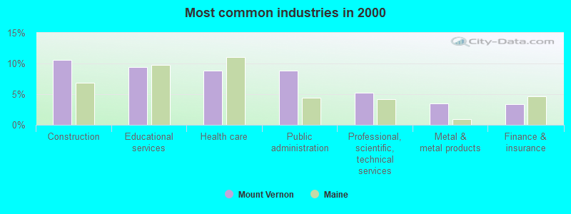
- Construction (10.6%)
- Educational services (9.4%)
- Health care (8.9%)
- Public administration (8.9%)
- Professional, scientific, technical services (5.3%)
- Metal & metal products (3.5%)
- Finance & insurance (3.4%)

- Construction (20.0%)
- Public administration (8.2%)
- Educational services (6.2%)
- Professional, scientific, technical services (5.8%)
- Motor vehicle & parts dealers (4.5%)
- Repair & maintenance (4.0%)
- Accommodation & food services (3.5%)

- Health care (15.0%)
- Educational services (12.5%)
- Public administration (9.5%)
- Food & beverage stores (5.0%)
- Finance & insurance (4.8%)
- Professional, scientific, technical services (4.8%)
- Metal & metal products (4.3%)

- Other management occupations, except farmers and farm managers (5.8%)
- Other office and administrative support workers, including supervisors (4.6%)
- Other production occupations, including supervisors (4.0%)
- Electrical equipment mechanics and other installation, maintenance, and repair workers, including supervisors (3.8%)
- Material recording, scheduling, dispatching, and distributing workers (3.6%)
- Preschool, kindergarten, elementary, and middle school teachers (3.5%)
- Carpenters (3.4%)
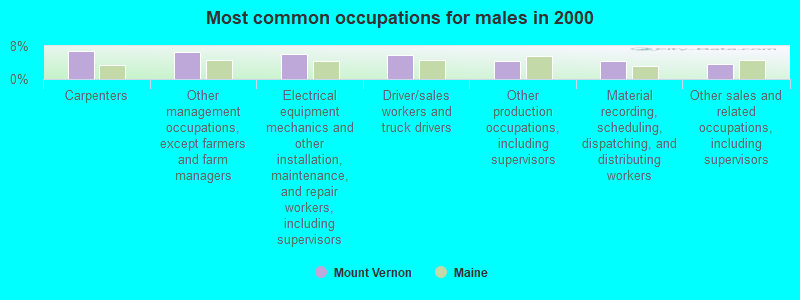
- Carpenters (6.8%)
- Other management occupations, except farmers and farm managers (6.5%)
- Electrical equipment mechanics and other installation, maintenance, and repair workers, including supervisors (6.0%)
- Driver/sales workers and truck drivers (5.8%)
- Other production occupations, including supervisors (4.2%)
- Material recording, scheduling, dispatching, and distributing workers (4.2%)
- Other sales and related occupations, including supervisors (3.8%)

- Other office and administrative support workers, including supervisors (7.3%)
- Other management occupations, except farmers and farm managers (5.0%)
- Information and record clerks, except customer service representatives (4.0%)
- Preschool, kindergarten, elementary, and middle school teachers (3.8%)
- Registered nurses (3.8%)
- Other production occupations, including supervisors (3.8%)
- Secretaries and administrative assistants (3.8%)
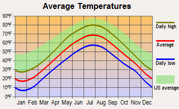
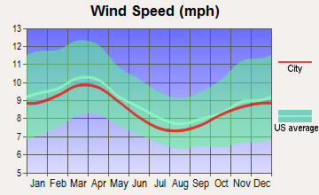
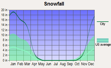
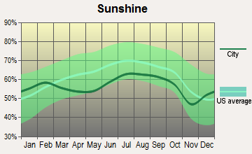
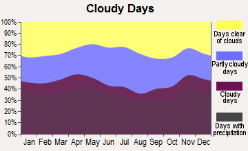
Average climate in Mount Vernon, Maine
Based on data reported by over 4,000 weather stations
(lower is better)
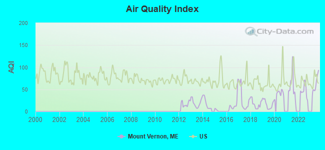
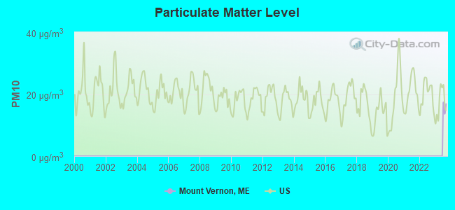
Air Quality Index (AQI) level in 2023 was 62.3. This is about average.
| City: | 62.3 |
| U.S.: | 72.6 |
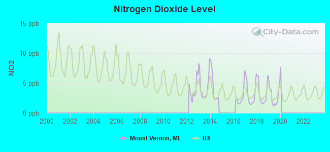
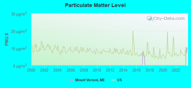
Nitrogen Dioxide (NO2) [ppb] level in 2019 was 2.80. This is significantly better than average. Closest monitor was 14.0 miles away from the city center.
| City: | 2.80 |
| U.S.: | 5.11 |
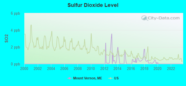
Sulfur Dioxide (SO2) [ppb] level in 2019 was 0.185. This is significantly better than average. Closest monitor was 10.9 miles away from the city center.
| City: | 0.185 |
| U.S.: | 1.515 |
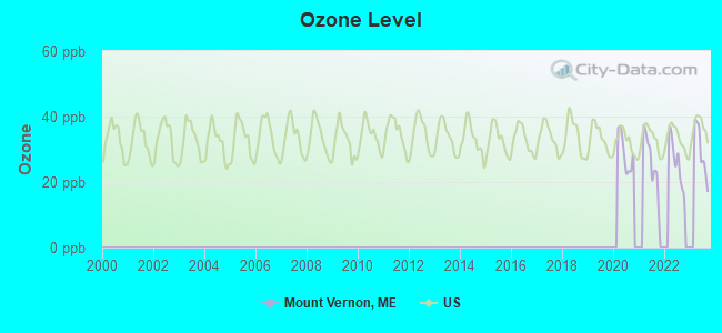
Ozone [ppb] level in 2023 was 29.5. This is about average. Closest monitor was 14.0 miles away from the city center.
| City: | 29.5 |
| U.S.: | 33.3 |
Earthquake activity:
Mount Vernon-area historical earthquake activity is significantly above Maine state average. It is 76% smaller than the overall U.S. average.On 4/20/2002 at 10:50:47, a magnitude 5.3 (5.3 ML, Depth: 3.0 mi, Class: Moderate, Intensity: VI - VII) earthquake occurred 184.4 miles away from Mount Vernon center
On 10/16/2012 at 23:12:25, a magnitude 4.7 (4.7 ML, Depth: 10.0 mi, Class: Light, Intensity: IV - V) earthquake occurred 69.3 miles away from Mount Vernon center
On 4/20/2002 at 10:50:47, a magnitude 5.2 (5.2 MB, 4.2 MS, 5.2 MW, 5.0 MW) earthquake occurred 185.4 miles away from the city center
On 10/7/1983 at 10:18:46, a magnitude 5.3 (5.1 MB, 5.3 LG, 5.1 ML) earthquake occurred 220.1 miles away from Mount Vernon center
On 1/19/1982 at 00:14:42, a magnitude 4.7 (4.5 MB, 4.7 MD, 4.5 LG) earthquake occurred 105.4 miles away from the city center
On 2/26/1999 at 03:38:43, a magnitude 3.8 (3.8 LG, Depth: 2.0 mi, Class: Light, Intensity: II - III) earthquake occurred 21.8 miles away from Mount Vernon center
Magnitude types: regional Lg-wave magnitude (LG), body-wave magnitude (MB), duration magnitude (MD), local magnitude (ML), surface-wave magnitude (MS), moment magnitude (MW)
Natural disasters:
The number of natural disasters in Kennebec County (21) is greater than the US average (15).Major Disasters (Presidential) Declared: 16
Emergencies Declared: 4
Causes of natural disasters: Floods: 13, Storms: 11, Snows: 5, Hurricanes: 3, Heavy Rains: 2, Blizzard: 1, Ice Storm: 1, Snowfall: 1, Wind: 1, Other: 2 (Note: some incidents may be assigned to more than one category).
Hospitals and medical centers near Mount Vernon:
- KENNEBEC KIDNEY CENTER (Dialysis Facility, about 12 miles away; AUGUSTA, ME)
- HERITAGE REHAB AND LIVING CTR (Nursing Home, about 12 miles away; WINTHROP, ME)
- KENNEBEC VALLEY MEDICAL CENTER (Hospital, about 14 miles away; AUGUSTA, ME)
- SANDY RIVER CENTER (Nursing Home, about 15 miles away; FARMINGTON, ME)
- RIVERVIEW PSYCHIATRIC CENTER (Hospital, about 15 miles away; AUGUSTA, ME)
- MAINE GENERAL REHAB AND NURSING AT GLENRIDGE (Nursing Home, about 15 miles away; AUGUSTA, ME)
- KINDRED TRANSITIONAL CARE AND REHAB-AUGUSTA (Nursing Home, about 15 miles away; AUGUSTA, ME)
located in Mount Vernon:
Colleges/universities with over 2000 students nearest to Mount Vernon:
- University of Maine at Augusta (about 13 miles; Augusta, ME; Full-time enrollment: 3,204)
- University of Maine at Farmington (about 17 miles; Farmington, ME; FT enrollment: 2,036)
- Saint Joseph's College of Maine (about 52 miles; Standish, ME; FT enrollment: 2,010)
- University of Southern Maine (about 58 miles; Portland, ME; FT enrollment: 6,647)
- Southern Maine Community College (about 59 miles; South Portland, ME; FT enrollment: 4,666)
- Husson University (about 63 miles; Bangor, ME; FT enrollment: 2,421)
- University of Maine (about 70 miles; Orono, ME; FT enrollment: 8,931)
Public elementary/middle school in Mount Vernon:
- MT VERNON ELEMENTARY SCHOOL (Location: 1507 NORTH ROAD, Grades: PK-5)
Points of interest:
Notable locations in Mount Vernon: Mount Vernon Fire Department (A), Mount Vernon Fire and Rescue (B). Display/hide their locations on the map
Cemeteries: Stevens Cemetery (1), Potash Cemetery (2), Dunns Cemetery (3), Marston Cemetery (4), Beam Cemetery (5), Philbrick Cemetery (6), Smith Cemetery (7). Display/hide their locations on the map
Lakes and reservoirs: Desert Pond (A), Doloff Pond (B), Hopkins Pond (C), Inghan Pond (D), Minnehonk Lake (E), Moose Pond (F), Parker Pond (G), Long Pond (H). Display/hide their locations on the map
Streams, rivers, and creeks: Hopkins Stream (A), Stony Brook (B), Intervale Brook (C), Ingham Stream (D), Moose Pond Stream (E), Bog Stream (F). Display/hide their locations on the map
Tourist attractions: Dew Animal Kingdom & Sanctuary (Cultural Attractions- Events- & Facilities; 918 Pond Road) (1), Mount Vernon Town Of (Cultural Attractions- Events- & Facilities; Library Drive) (2). Display/hide their approximate locations on the map
Birthplace of: John H. Rice - Politician, Loren Fletcher - Politician.
Drinking water stations with addresses in Mount Vernon and their reported violations in the past:
KIDS R SPECIAL CHILD CARE CENTER (Population served: 32, Groundwater):Past health violations:Past monitoring violations:
- MCL, Monthly (TCR) - In NOV-2011, Contaminant: Coliform. Follow-up actions: St Formal NOV issued (DEC-08-2011), St Public Notif requested (DEC-08-2011), St AO (w/o penalty) issued (JAN-27-2012), St Public Notif received (FEB-17-2012), St Compliance achieved (MAY-24-2012)
- MCL, Monthly (TCR) - In AUG-2011, Contaminant: Coliform. Follow-up actions: St Public Notif requested (AUG-17-2011), St Formal NOV issued (AUG-17-2011), St Compliance achieved (SEP-27-2011), St AO (w/o penalty) issued (JAN-27-2012), St Public Notif received (FEB-17-2012)
- MCL, Monthly (TCR) - In JUL-2011, Contaminant: Coliform. Follow-up actions: St Formal NOV issued (AUG-01-2011), St Public Notif requested (AUG-01-2011), St Compliance achieved (SEP-27-2011), St AO (w/o penalty) issued (JAN-27-2012), St Public Notif received (FEB-17-2012)
- One routine major monitoring violation
- One regular monitoring violation
| This town: | 2.4 people |
| Maine: | 2.3 people |
| This town: | 70.3% |
| Whole state: | 62.9% |
| This town: | 11.4% |
| Whole state: | 9.4% |
Likely homosexual households (counted as self-reported same-sex unmarried-partner households)
- Lesbian couples: 1.0% of all households
- Gay men: 0.7% of all households
| This town: | 7.1% |
| Whole state: | 10.9% |
| This town: | 2.6% |
| Whole state: | 4.1% |
For population 15 years and over in Mount Vernon:
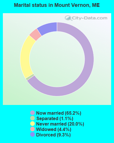
- Never married: 20.0%
- Now married: 65.2%
- Separated: 1.1%
- Widowed: 4.4%
- Divorced: 9.3%
For population 25 years and over in Mount Vernon:
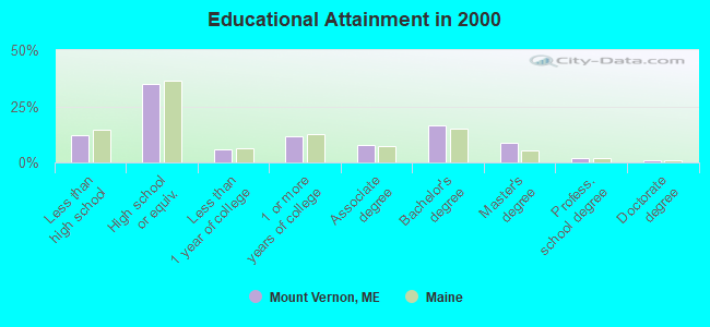
- High school or higher: 88.0%
- Bachelor's degree or higher: 27.8%
- Graduate or professional degree: 11.5%
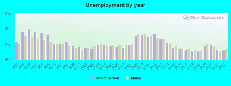
- Unemployed: 3.2%
- Mean travel time to work (commute): 31.7 minutes
| Here: | 11.1 |
| Maine average: | 11.2 |
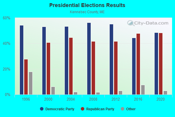
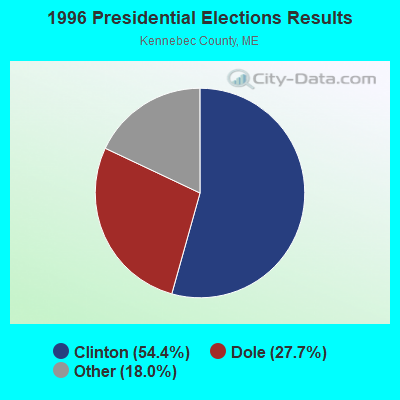
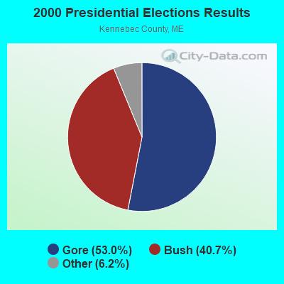


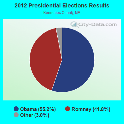


Graphs represent county-level data. Detailed 2008 Election Results
Religion statistics for Mount Vernon, ME (based on Kennebec County data)
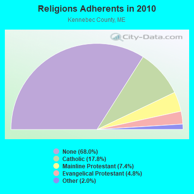
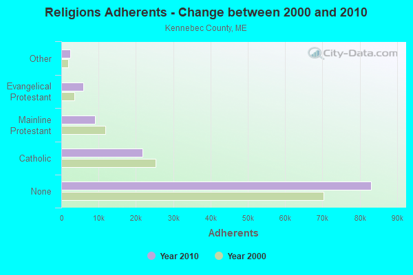
| Religion | Adherents | Congregations |
|---|---|---|
| Catholic | 21,758 | 11 |
| Mainline Protestant | 8,999 | 60 |
| Evangelical Protestant | 5,829 | 56 |
| Other | 2,466 | 17 |
| None | 83,099 | - |
Food Environment Statistics:
| Here: | 1.99 / 10,000 pop. |
| Maine: | 2.80 / 10,000 pop. |
| This county: | 0.17 / 10,000 pop. |
| Maine: | 0.14 / 10,000 pop. |
| This county: | 1.41 / 10,000 pop. |
| Maine: | 2.20 / 10,000 pop. |
| This county: | 6.38 / 10,000 pop. |
| State: | 5.75 / 10,000 pop. |
| This county: | 8.70 / 10,000 pop. |
| Maine: | 11.02 / 10,000 pop. |
| This county: | 8.6% |
| Maine: | 8.2% |
| Kennebec County: | 28.2% |
| Maine: | 25.0% |
Strongest AM radio stations in Mount Vernon:
- WTME (780 AM; 10 kW; RUMFORD, ME; Owner: MOUNTAIN VALLEY BROADCASTING, INC.)
- WSKW (1160 AM; 10 kW; SKOWHEGAN, ME; Owner: MOUNTAIN WIRELESS, INCORPORATED)
- WFAU (1280 AM; 5 kW; GARDINER, ME; Owner: CAPSTAR TX LIMITED PARTNERSHIP)
- WMDR (1340 AM; 1 kW; AUGUSTA, ME; Owner: LIGHT OF LIFE MINISTRIES, INC.)
- WLAM (1470 AM; 5 kW; LEWISTON, ME; Owner: RADIO PARTNERS OF MAINE, L.P.)
- WEZW (1400 AM; 1 kW; AUGUSTA, ME; Owner: CITADEL BROADCASTING COMPANY)
- WRKO (680 AM; 50 kW; BOSTON, MA; Owner: ENTERCOM BOSTON LICENSE, LLC)
- WMTW (870 AM; 10 kW; GORHAM, ME; Owner: RADIO PARTNERS OF MAINE, L.P.)
- WGAN (560 AM; 5 kW; PORTLAND, ME; Owner: SAGA COMMUNICATIONS OF NEW ENGLAND, LLC)
- WEEI (850 AM; 50 kW; BOSTON, MA; Owner: ENTERCOM BOSTON LICENSE, LLC)
- WTVL (1490 AM; 1 kW; WATERVILLE, ME; Owner: CITADEL BROADCASTING COMPANY)
- WBZ (1030 AM; 50 kW; BOSTON, MA; Owner: INFINITY BROADCASTING OPERATIONS, INC.)
- WZON (620 AM; 5 kW; BANGOR, ME; Owner: THE ZONE CORPORATION)
Strongest FM radio stations in Mount Vernon:
- WWWA (95.3 FM; WINSLOW, ME; Owner: LIGHT OF LIFE MINISTRIES, INC.)
- WTOS-FM (105.1 FM; SKOWHEGAN, ME; Owner: CAPSTAR TX LIMITED PARTNERSHIP)
- WPKQ (103.7 FM; NORTH CONWAY, NH; Owner: CITADEL BROADCASTING COMPANY)
- WHOM (94.9 FM; MT. WASHINGTON, NH; Owner: CITADEL BROADCASTING COMPANY)
- WLOB-FM (96.3 FM; RUMFORD, ME; Owner: ATLANTIC COAST RADIO, LLC)
- WABK-FM (104.3 FM; GARDINER, ME; Owner: CAPSTAR TX LIMITED PARTNERSHIP)
- WHQO (107.9 FM; SKOWHEGAN, ME; Owner: MOUNTAIN WIRELESS, INC.)
- WMME-FM (92.3 FM; AUGUSTA, ME; Owner: CITADEL BROADCASTING COMPANY)
- WTBM (100.7 FM; MEXICO, ME; Owner: MOUNTAIN VALLEY BROADCASTING, INC.)
- WKCG (101.3 FM; AUGUSTA, ME; Owner: CAPSTAR TX LIMITED PARTNERSHIP)
- WCYI (93.9 FM; LEWISTON, ME; Owner: CITADEL BROADCASTING COMPANY)
- WMEA (90.1 FM; PORTLAND, ME; Owner: MAINE PUBLIC BROADCASTING CORPORATION)
- WKTJ-FM (99.3 FM; FARMINGTON, ME; Owner: FRANKLIN BROADCASTING CORPORATION)
- WBLM (102.9 FM; PORTLAND, ME; Owner: CITADEL BROADCASTING COMPANY)
- WMEP (90.5 FM; CAMDEN, ME; Owner: MAINE PUBLIC BROADCASTING CORP.)
- WMEW (91.3 FM; WATERVILLE, ME; Owner: MAINE PUBLIC BROADCASTING CORPORATION)
- WQSS (102.5 FM; CAMDEN, ME; Owner: CLEAR CHANNEL BROADCASTING LICENSES, INC.)
- WWBX (97.1 FM; BANGOR, ME; Owner: CLEAR CHANNEL BROADCASTING LICENSES, INC.)
- WTHT (107.5 FM; LEWISTON, ME; Owner: RADIO PARTNERS OF MAINE, L.P.)
- WCTB (93.5 FM; FAIRFIELD, ME; Owner: MOUNTAIN WIRELESS, INC.)
TV broadcast stations around Mount Vernon:
- WPFO (Channel 23; WATERVILLE, ME; Owner: CMCG PORTLAND LICENSE LLC)
- WCBB (Channel 10; AUGUSTA, ME; Owner: MAINE PUBLIC BROADCASTING CORP.)
- WGME-TV (Channel 13; PORTLAND, ME; Owner: WGME LICENSEE, LLC)
- WFYW-LP (Channel 69; FAIRFIELD/WATERVILLE, ME; Owner: THREE ANGELS BROADCASTING NETWORK, INC.)
- W21BI (Channel 21; FARMINGTON, ME; Owner: TRINITY BROADCASTING NETWORK)
- DW23AB (Channel 23; WATERVILLE, ME; Owner: RUSSELL COMMUNICATIONS)
- Mount Vernon, Maine
- Fatal accident count13
- Vehicles involved in fatal accidents17
- Fatal accidents involving drunk persons:8
- Fatalities15
- Persons involved in fatal accidents31
- Pedestrians involved in fatal accidents3
- Maine average
- Fatal accident count2116
- Vehicles involved in fatal accidents3088
- Fatal accidents involving drunk persons734
- Fatalities2344
- Persons involved in fatal accidents5090
- Pedestrians involved in fatal accidents157
- National Bridge Inventory (NBI) Statistics
- 5Number of bridges
- 23ft / 7.2mTotal length
- 4,051Total average daily traffic
- 287Total average daily truck traffic
- 6,437Total future (year 2036) average daily traffic
FCC Registered Antenna Towers:
6- Leslie N Nixon, 281 Blake Hill Rd. (Lat: 44.475139 Lon: -69.980750), Type: 60.7, Structure height: 23011 m, Overall height: 60.7 m, Registrant: Global Tower, LLC, Fcc-Contact@gtpsites.Com, , Boca -Raton, Phone: (561) 995-0320
- Leslie N Nixon, 281 Blake Hill Rd. (Lat: 44.475139 Lon: -69.980750), Type: 60.7, Structure height: 23011 m, Overall height: 60.7 m, Registrant: Global Tower, LLC, Fcc-Contact@gtpsites.Com, , Boca -Raton, Phone: (561) 995-0320
- Kristen Cesana, 281 Blake Hill Rd. (Lat: 44.475139 Lon: -69.980750), Type: 60.7, Structure height: 23011 m, Overall height: 60.7 m, Registrant: American Towers, LLC., Faa-Fcc@americantower.Com, , Wobur-n, Phone: (678) 265-6770
- Bridget Carter, 281 Blake Hill Rd. (Lat: 44.475139 Lon: -69.980750), Type: 60.7, Structure height: 23011 m, Overall height: 60.7 m, Registrant: American Towers, LLC., Faa-Fcc@americantower.Com, , Wobur-n, Phone: (678) 265-6770
- Bridget Carter, 281 Blake Hill Rd. (#371945) (Lat: 44.475139 Lon: -69.980750), Type: 60.7, Structure height: 23011 m, Overall height: 58.2 m, Registrant: American Towers, LLC., Faa-Fcc@americantower.Com, , Wobur-n, Phone: (678) 564-3236
- Bridget Carter, 281 Blake Hill Rd. (#371945) (Lat: 44.475139 Lon: -69.980750), Type: 60.7, Structure height: 23011 m, Overall height: 58.2 m, Licensee ID: L, Registrant: American Towers LLC, Faa-Fcc@americantower.Com, , Wobur-n, Phone: (678) 564-3236
FCC Registered Microwave Towers:
2- Mt Vernon, 281 Blake Hill Rd. (Lat: 44.475167 Lon: -69.980750), Type: Ltower, Structure height: 58.2 m, Call Sign: WQXK282,
Assigned Frequencies: 10735.0 MHz, 10735.0 MHz, 10735.0 MHz, 10735.0 MHz, 10735.0 MHz, 10735.0 MHz, 10735.0 MHz, 10735.0 MHz, 10735.0 MHz, 19525.0 MHz... (+8 more), Grant Date: 03/29/2016, Expiration Date: 03/29/2026, Cancellation Date: 05/18/2020, Certifier: Jessica B Lyons, Registrant: At&t Services, Inc., 208 S. Akard St., Room 2100, Dallas, TX 75202, Phone: (855) 699-7073, Email:
- Vienna, 16 Besse Rd (Lat: 44.548361 Lon: -70.020139), Type: Ltower, Structure height: 58.2 m, Overall height: 58.5 m, Call Sign: WQYG648,
Assigned Frequencies: 11225.0 MHz, 11225.0 MHz, 11225.0 MHz, 11225.0 MHz, 11225.0 MHz, 11225.0 MHz, Grant Date: 09/21/2016, Expiration Date: 09/21/2026, Cancellation Date: 10/21/2020, Certifier: Jessica B Lyons, Registrant: At&t Services, Inc., 208 S. Akard Street, Room 2100, Dallas, TX 75202, Phone: (855) 699-7073, Email:
FCC Registered Amateur Radio Licenses:
17 (See the full list of FCC Registered Amateur Radio Licenses in Mount Vernon)FAA Registered Aircraft:
1- Aircraft: CHAMPION 7EC (Category: Land, Seats: 2, Weight: Up to 12,499 Pounds, Speed: 90 mph), Engine: CONT MOTOR C90 SERIES (95 HP) (Reciprocating)
N-Number: 7401B, N7401B, N-7401B, Serial Number: 7EC-431, Year manufactured: 1956, Airworthiness Date: 05/28/1956, Certificate Issue Date: 04/23/2020
Registrant (Individual): Matthew D Sylvester, Po Box 181, Mount Vernon, ME 04352
2005 - 2018 National Fire Incident Reporting System (NFIRS) incidents
- Fire incident types reported to NFIRS in Mount Vernon, ME
- 10375.2%Structure Fires
- 2014.6%Outside Fires
- 128.8%Mobile Property/Vehicle Fires
- 21.5%Other
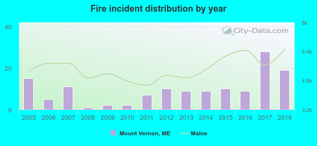 According to the data from the years 2005 - 2018 the average number of fire incidents per year is 10. The highest number of reported fires - 28 took place in 2017, and the least - 1 in 2008. The data has an increasing trend.
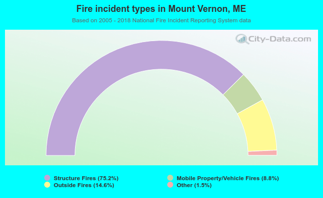 When looking into fire subcategories, the most incidents belonged to: Structure Fires (75.2%), and Outside Fires (14.6%).
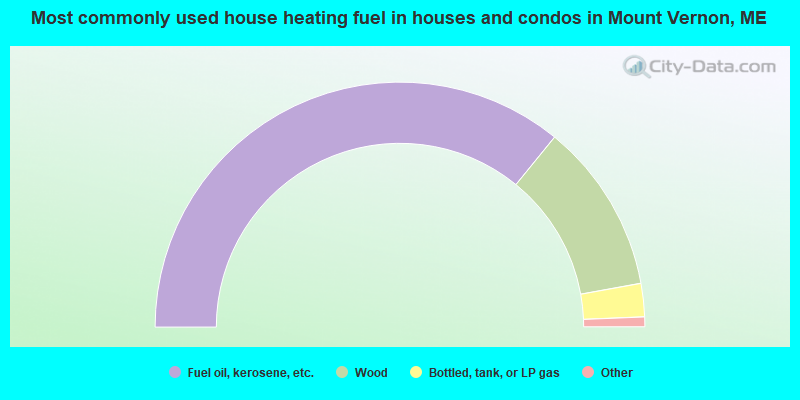
- 71.7%Fuel oil, kerosene, etc.
- 22.5%Wood
- 4.4%Bottled, tank, or LP gas
- 1.0%Electricity
- 0.4%Coal or coke
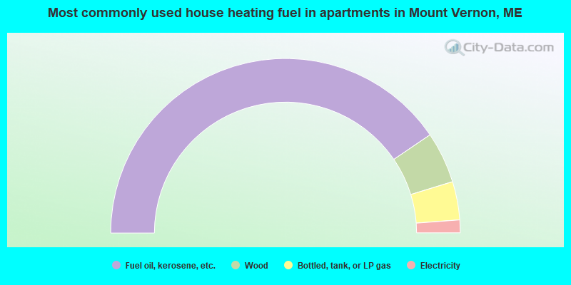
- 81.0%Fuel oil, kerosene, etc.
- 9.5%Wood
- 7.1%Bottled, tank, or LP gas
- 2.4%Electricity
Mount Vernon compared to Maine state average:
- Unemployed percentage significantly below state average.
- Black race population percentage significantly below state average.
- Hispanic race population percentage below state average.
- Foreign-born population percentage significantly below state average.
- Renting percentage significantly below state average.
- Length of stay since moving in significantly above state average.
- Number of rooms per house significantly below state average.
- House age significantly below state average.

|
Total of 5 patent applications in 2008-2024.