Nesmith, South Carolina
Submit your own pictures of this place and show them to the world
- OSM Map
- General Map
- Google Map
- MSN Map

| Males: 1,674 | |
| Females: 1,761 |
| Median resident age: | 34.5 years |
| South Carolina median age: | 35.4 years |
Zip code: 29510
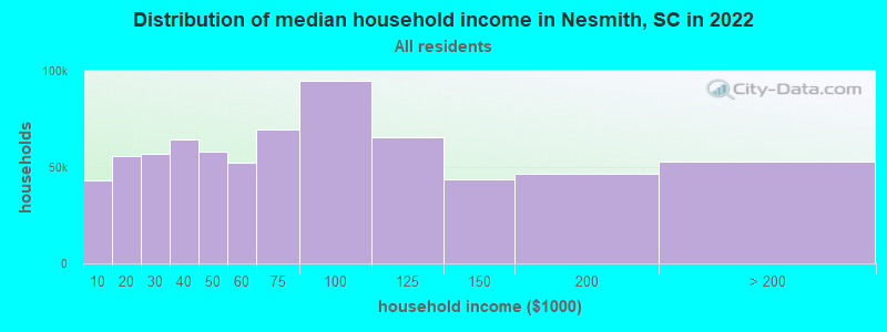
| Nesmith: | $41,723 |
| SC: | $64,115 |
Estimated per capita income in 2022: $19,850 (it was $10,886 in 2000)
Nesmith CCD income, earnings, and wages data
Estimated median house or condo value in 2022: $90,455 (it was $43,400 in 2000)
| Nesmith: | $90,455 |
| SC: | $254,600 |
Detailed information about poverty and poor residents in Nesmith, SC
Compare current foreclosures near Nesmith, SC:
| Photo | Address | Area | Beds / Baths | Price | Details |
|---|---|---|---|---|---|

|
#1
Sandy Pine Loop
Nesmith, SC 29580
|
1,025 sq. feet
|
- baths - beds |
show details | |

|
#2
Hayfield Rd
Georgetown, SC 29440
|
1,680 sq. feet
|
2 baths 3 beds |
$100,000
|
show details |

|
#3
Stina Ave
Hemingway, SC 29554
|
1,352 sq. feet
|
2 baths 3 beds |
$105,000
|
show details |

|
#4
Sherwood St
Kingstree, SC 29556
|
1,458 sq. feet
|
- baths - beds |
$39,900
|
show details |

|
#5
E Andrews St
Hemingway, SC 29554
|
1,092 sq. feet
|
1 baths 3 beds |
show details | |

|
#6
Cody Ln
Georgetown, SC 29440
|
1,386 sq. feet
|
1 baths 2 beds |
show details | |

|
#7
Center Rd
Georgetown, SC 29440
|
3,300 sq. feet
|
3 baths 4 beds |
show details | |

|
#8
S State Highway 41-51
Hemingway, SC 29554
|
1,578 sq. feet
|
2 baths 3 beds |
show details | |

|
#9
Sandhurst St
Kingstree, SC 29556
|
1,340 sq. feet
|
1 baths 4 beds |
show details | |

|
#10
Pinckney Rd
Kingstree, SC 29556
|
- sq. feet
|
- baths - beds |
show details |
| Photo | Address | Area | Beds / Baths | Price | Details |
|---|---|---|---|---|---|

|
#11
White Oak Rd
Lake City, SC 29560
|
- sq. feet
|
- baths - beds |
show details | |

|
#12
Rolling Hills Dr
Johnsonville, SC 29555
|
- sq. feet
|
- baths - beds |
show details | |

|
#13
William Cooper Dr
Kingstree, SC 29556
|
- sq. feet
|
- baths - beds |
show details | |

|
#14
Jericho Rd
Kingstree, SC 29556
|
- sq. feet
|
- baths - beds |
show details | |

|
#15
Martin Luther King Ave # 133
Kingstree, SC 29556
|
- sq. feet
|
- baths - beds |
show details | |

|
#16
Shine Rd
Johnsonville, SC 29555
|
- sq. feet
|
- baths - beds |
show details | |

|
#17
Lexington Ave
Kingstree, SC 29556
|
- sq. feet
|
- baths - beds |
show details | |

|
#18
Lexington Ave
Kingstree, SC 29556
|
- sq. feet
|
- baths - beds |
show details | |

|
#19
N Brooks St Apt 4g
Kingstree, SC 29556
|
- sq. feet
|
- baths - beds |
show details | |

|
#20
Cyrus St
Kingstree, SC 29556
|
- sq. feet
|
- baths - beds |
show details |
| Photo | Address | Area | Beds / Baths | Price | Details |
|---|---|---|---|---|---|

|
#21
E County Line Rd
Hemingway, SC 29554
|
- sq. feet
|
- baths - beds |
show details | |

|
#22
Jock Trl
Georgetown, SC 29440
|
- sq. feet
|
- baths - beds |
show details | |

|
#23
James Lee Pl
Georgetown, SC 29440
|
- sq. feet
|
- baths - beds |
show details | |

|
#24
Indiantown Swamp Rd
Hemingway, SC 29554
|
- sq. feet
|
- baths - beds |
show details | |

|
#25
Morrisville Rd
Andrews, SC 29510
|
- sq. feet
|
- baths - beds |
show details | |

|
#26
Hollywood Ave
Andrews, SC 29510
|
- sq. feet
|
- baths - beds |
show details | |

|
#27
Angel Rd
Hemingway, SC 29554
|
1,025 sq. feet
|
- baths - beds |
show details | |

|
#28
Dogwood St
Andrews, SC 29510
|
- sq. feet
|
- baths - beds |
show details | |

|
#29
Cc Gordon Ln
Hemingway, SC 29554
|
- sq. feet
|
- baths - beds |
show details | |

|
#30
W Myrtle Rd
Andrews, SC 29510
|
- sq. feet
|
- baths - beds |
show details |
| Photo | Address | Area | Beds / Baths | Price | Details |
|---|---|---|---|---|---|

|
#31
Country Club Rd
Andrews, SC 29510
|
- sq. feet
|
- baths - beds |
show details | |

|
#32
Owens Corner Dr
Hemingway, SC 29554
|
- sq. feet
|
- baths - beds |
show details | |

|
#33
Jerome Dr
Georgetown, SC 29440
|
- sq. feet
|
- baths - beds |
show details | |

|
#34
Powell Rd
Georgetown, SC 29440
|
- sq. feet
|
- baths - beds |
show details | |

|
#35
Cane Branch Rd
Kingstree, SC 29556
|
- sq. feet
|
- baths - beds |
show details | |

|
#36
Josephine Ln
Kingstree, SC 29556
|
- sq. feet
|
- baths - beds |
show details | |

|
#37
Lark Ln
Andrews, SC 29510
|
- sq. feet
|
- baths - beds |
show details | |

|
#38
Juniper Ln
Lake City, SC 29560
|
- sq. feet
|
- baths - beds |
show details | |

|
#39
I M Graham Rd
Kingstree, SC 29556
|
- sq. feet
|
- baths - beds |
show details | |

|
#40
Sandridge Rd
Kingstree, SC 29556
|
- sq. feet
|
- baths - beds |
show details |
| Photo | Address | Area | Beds / Baths | Price | Details |
|---|---|---|---|---|---|

|
#41
Tranquil Ln
Kingstree, SC 29556
|
- sq. feet
|
- baths - beds |
show details | |

|
#42
Florence Ln
Kingstree, SC 29556
|
- sq. feet
|
- baths - beds |
show details | |

|
#43
Poplar Rd
Kingstree, SC 29556
|
- sq. feet
|
- baths - beds |
show details | |

|
#44
Hemingway Hwy
Kingstree, SC 29556
|
- sq. feet
|
- baths - beds |
show details | |

|
#45
Ike Mitchum Rd
Kingstree, SC 29556
|
- sq. feet
|
- baths - beds |
show details | |

|
#46
Nice Ave
Salters, SC 29590
|
- sq. feet
|
- baths - beds |
show details | |

|
Check over 1 million property listings on Foreclosure.com!
|
browse all offers | |||

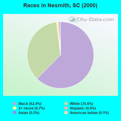
- 2,25862.4%Black alone
- 1,28935.6%White alone
- 240.7%Two or more races
- 230.6%Hispanic
- 180.5%Asian alone
- 50.1%American Indian alone
Races in Nesmith detailed stats: ancestries, foreign born residents, place of birth
 Recent articles from our blog. Our writers, many of them Ph.D. graduates or candidates, create easy-to-read articles on a wide variety of topics.
Current Local Time: EST time zone
Elevation: 70 feet
Land area: 145.5 square miles.
Population density: 24 people per square mile (very low).

| Nesmith CCD: | 0.6% ($262) |
| South Carolina: | 0.6% ($510) |
Nearest city with pop. 50,000+: North Charleston, SC  (55.9 miles , pop. 79,641).
Nearest city with pop. 200,000+: Charlotte, NC (133.2 miles , pop. 540,828).
Nearest city with pop. 1,000,000+: Philadelphia, PA (505.6 miles , pop. 1,517,550).
Nearest cities:
), ), ), ), ), ), )Latitude: 33.59 N, Longitude: 79.55 W
Area code commonly used in this area: 843

| Here: | 5.1% |
| South Carolina: | 3.1% |
- Educational services (9.6%)
- Health care (8.1%)
- Accommodation & food services (7.1%)
- Textile mills & textile products (6.3%)
- Apparel (5.4%)
- Plastics & rubber products (5.4%)
- Metal & metal products (5.0%)
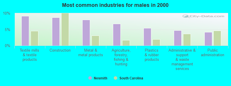
- Textile mills & textile products (9.1%)
- Construction (8.7%)
- Metal & metal products (7.9%)
- Agriculture, forestry, fishing & hunting (6.7%)
- Plastics & rubber products (5.4%)
- Administrative & support & waste management services (4.6%)
- Public administration (4.2%)
- Educational services (19.1%)
- Health care (16.9%)
- Accommodation & food services (11.4%)
- Apparel (9.5%)
- Plastics & rubber products (5.5%)
- Food & beverage stores (4.3%)
- Social assistance (3.7%)
- Other production occupations, including supervisors (9.8%)
- Building and grounds cleaning and maintenance occupations (6.8%)
- Textile, apparel, and furnishings workers (6.7%)
- Preschool, kindergarten, elementary, and middle school teachers (5.0%)
- Electrical equipment mechanics and other installation, maintenance, and repair workers, including supervisors (4.3%)
- Metal workers and plastic workers (4.0%)
- Driver/sales workers and truck drivers (3.7%)
- Other production occupations, including supervisors (12.9%)
- Electrical equipment mechanics and other installation, maintenance, and repair workers, including supervisors (8.2%)
- Driver/sales workers and truck drivers (7.2%)
- Building and grounds cleaning and maintenance occupations (6.9%)
- Metal workers and plastic workers (5.5%)
- Other sales and related occupations, including supervisors (5.5%)
- Laborers and material movers, hand (5.1%)
- Textile, apparel, and furnishings workers (11.7%)
- Preschool, kindergarten, elementary, and middle school teachers (9.6%)
- Secretaries and administrative assistants (6.8%)
- Building and grounds cleaning and maintenance occupations (6.8%)
- Other production occupations, including supervisors (6.4%)
- Registered nurses (5.5%)
- Other teachers, instructors, education, training, and library occupations (5.1%)
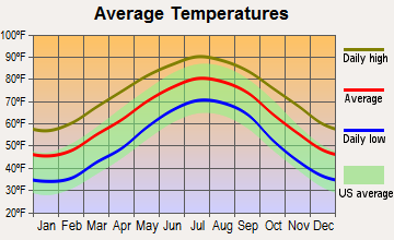
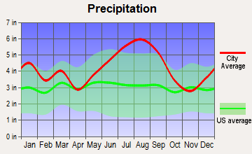
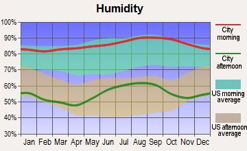
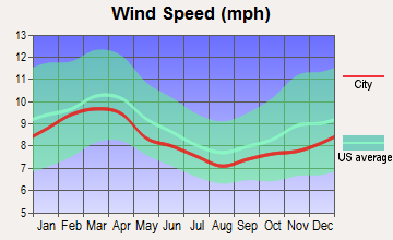
Average climate in Nesmith, South Carolina
Based on data reported by over 4,000 weather stations

(lower is better)
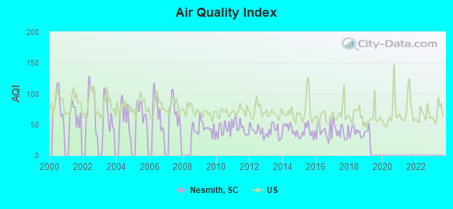
Air Quality Index (AQI) level in 2018 was 36.9. This is significantly better than average.
| City: | 36.9 |
| U.S.: | 72.6 |
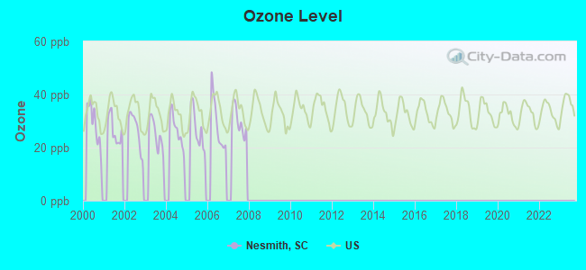
Ozone [ppb] level in 2007 was 30.1. This is about average. Closest monitor was 9.0 miles away from the city center.
| City: | 30.1 |
| U.S.: | 33.3 |
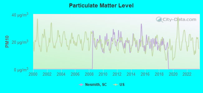
Particulate Matter (PM10) [µg/m3] level in 2018 was 17.8. This is about average. Closest monitor was 20.9 miles away from the city center.
| City: | 17.8 |
| U.S.: | 19.2 |
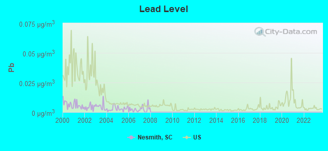
Lead (Pb) [µg/m3] level in 2007 was 0.00315. This is significantly better than average. Closest monitor was 21.4 miles away from the city center.
| City: | 0.00315 |
| U.S.: | 0.00931 |
Tornado activity:
Nesmith-area historical tornado activity is slightly below South Carolina state average. It is 16% smaller than the overall U.S. average.
On 11/7/1995, a category F4 (max. wind speeds 207-260 mph) tornado 37.1 miles away from the Nesmith place center injured one person and caused between $500,000 and $5,000,000 in damages.
On 11/24/1967, a category F3 (max. wind speeds 158-206 mph) tornado 30.1 miles away from the place center injured one person and caused between $5000 and $50,000 in damages.
Earthquake activity:
Nesmith-area historical earthquake activity is significantly above South Carolina state average. It is 51% smaller than the overall U.S. average.On 11/22/1974 at 05:25:55, a magnitude 4.7 (4.7 MB, Class: Light, Intensity: IV - V) earthquake occurred 59.0 miles away from the city center
On 8/23/2011 at 17:51:04, a magnitude 5.8 (5.8 MW, Depth: 3.7 mi, Class: Moderate, Intensity: VI - VII) earthquake occurred 311.9 miles away from Nesmith center
On 8/21/1992 at 16:31:55, a magnitude 4.4 (4.1 MB, 4.1 LG, 4.4 LG, Depth: 6.2 mi) earthquake occurred 49.8 miles away from the city center
On 8/2/1974 at 08:52:09, a magnitude 4.9 (4.3 MB, 4.9 LG) earthquake occurred 169.9 miles away from the city center
On 8/9/2020 at 12:07:37, a magnitude 5.1 (5.1 MW, Depth: 4.7 mi) earthquake occurred 217.5 miles away from Nesmith center
On 4/17/1995 at 13:45:57, a magnitude 3.9 (3.9 LG, Depth: 6.2 mi, Class: Light, Intensity: II - III) earthquake occurred 53.8 miles away from the city center
Magnitude types: regional Lg-wave magnitude (LG), body-wave magnitude (MB), moment magnitude (MW)
Natural disasters:
The number of natural disasters in Williamsburg County (19) is greater than the US average (15).Major Disasters (Presidential) Declared: 10
Emergencies Declared: 5
Causes of natural disasters: Hurricanes: 10, Winter Storms: 3, Floods: 2, Storms: 2, Tropical Storms: 2, Ice Storm: 1, Other: 1 (Note: some incidents may be assigned to more than one category).
Colleges/universities with over 2000 students nearest to Nesmith:
- Coastal Carolina University (about 35 miles; Conway, SC; Full-time enrollment: 8,881)
- Horry-Georgetown Technical College (about 35 miles; Conway, SC; FT enrollment: 5,772)
- Francis Marion University (about 42 miles; Florence, SC; FT enrollment: 3,624)
- Florence-Darlington Technical College (about 48 miles; Florence, SC; FT enrollment: 4,468)
- Charleston Southern University (about 52 miles; Charleston, SC; FT enrollment: 3,012)
- Central Carolina Technical College (about 53 miles; Sumter, SC; FT enrollment: 3,108)
- Trident Technical College (about 54 miles; Charleston, SC; FT enrollment: 13,125)
Points of interest:
Notable locations in Nesmith: Rhems Plantation (A), Williamsburg County Fire Department Morrisville (B), Williamsburg County Fire Department Bloomingville (C), Williamsburg County Fire Department Nesmith (D). Display/hide their locations on the map
Churches in Nesmith include: Sand Hill Church (A), Snow Hill Church (B), Saint Marks Church (C), Saint Johns Church (D), Piney Forest Church (E), Nesmith Missionary Baptist Church (F), Mount Zion Church (G), Asbury Church (H), Weldon Church (I). Display/hide their locations on the map
Cemeteries: Elim Cemetery (1), Bloomingvale Cemetery (2), Black Mingo Cemetery (3), Nesmith Cemetery (4). Display/hide their locations on the map
Lakes, reservoirs, and swamps: Wilson Lake (A), Browns Pond (B), Rames Farm Pond (C), Lakewood Pond (D), Brockington Pond (E), Baker Swamp (F), Cedar Bay (G). Display/hide their locations on the map
Streams, rivers, and creeks: Birch Creek (A), Snow Branch (B), Sleeper Branch (C), Roper Branch (D), Rome Branch (E), Poplar Hill Branch (F), Smith Swamp (G), Spring Branch (H), Johnson Branch (I). Display/hide their locations on the map
| This place: | 2.6 people |
| South Carolina: | 2.5 people |
| This place: | 70.1% |
| Whole state: | 67.5% |
| This place: | 5.2% |
| Whole state: | 6.0% |
Likely homosexual households (counted as self-reported same-sex unmarried-partner households)
- Lesbian couples: 0.0% of all households
- Gay men: 0.3% of all households
| This place: | 23.1% |
| Whole state: | 14.1% |
| This place: | 6.1% |
| Whole state: | 6.5% |
For population 15 years and over in Nesmith:
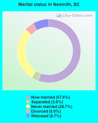
- Never married: 28.7%
- Now married: 57.6%
- Separated: 3.8%
- Widowed: 8.7%
- Divorced: 5.0%
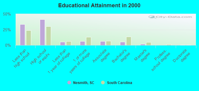
For population 25 years and over in Nesmith:
- High school or higher: 66.7%
- Bachelor's degree or higher: 7.3%
- Graduate or professional degree: 2.2%
- Unemployed: 9.2%
- Mean travel time to work (commute): 38.5 minutes
| Here: | 13.7 |
| South Carolina average: | 13.2 |

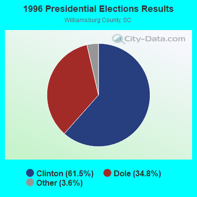
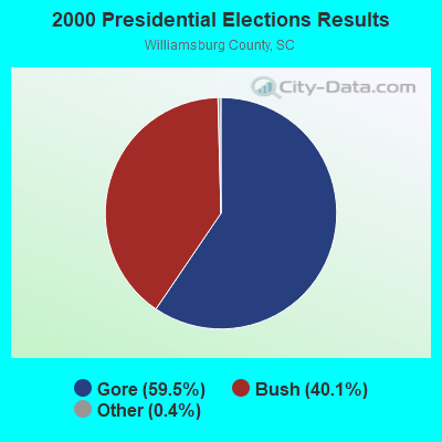
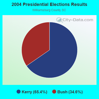
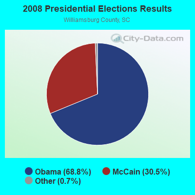

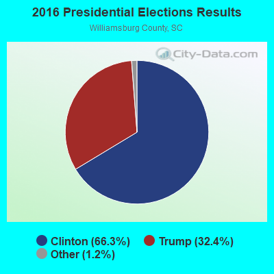
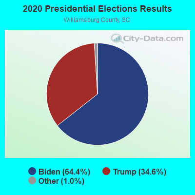
Graphs represent county-level data. Detailed 2008 Election Results
Religion statistics for Nesmith, SC (based on Williamsburg County data)
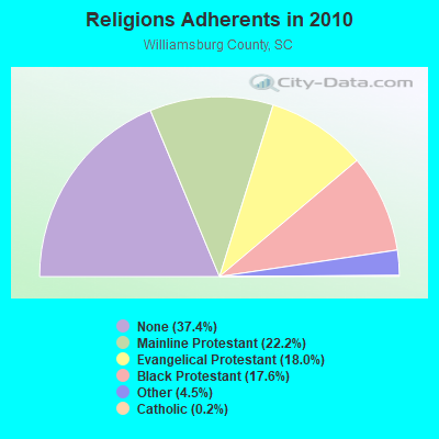
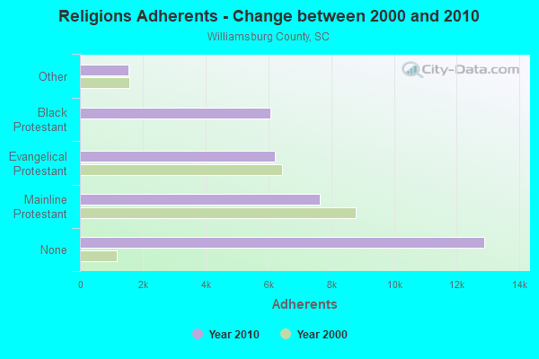
| Religion | Adherents | Congregations |
|---|---|---|
| Mainline Protestant | 7,632 | 43 |
| Evangelical Protestant | 6,201 | 47 |
| Black Protestant | 6,067 | 30 |
| Other | 1,550 | 2 |
| Catholic | 85 | 1 |
| None | 12,888 | - |
Food Environment Statistics:
| Here: | 2.26 / 10,000 pop. |
| South Carolina: | 1.99 / 10,000 pop. |
| This county: | 1.41 / 10,000 pop. |
| South Carolina: | 0.85 / 10,000 pop. |
| Williamsburg County: | 5.94 / 10,000 pop. |
| State: | 5.38 / 10,000 pop. |
| This county: | 3.39 / 10,000 pop. |
| State: | 7.75 / 10,000 pop. |
| Williamsburg County: | 13.2% |
| South Carolina: | 10.6% |
| Here: | 39.5% |
| South Carolina: | 29.4% |
| Williamsburg County: | 13.7% |
| South Carolina: | 13.4% |
Strongest AM radio stations in Nesmith:
- WDKD (1310 AM; 5 kW; KINGSTREE, SC; Owner: MILLER COMMUNICATIONS, INC.)
- WHYM (1260 AM; 5 kW; LAKE CITY, SC; Owner: GHB OF LAKE CITY, INC.)
- WCEO (840 AM; daytime; 50 kW; COLUMBIA, SC; Owner: EASTERN BROADCASTING GROUP, INC.)
- WQTK (950 AM; 10 kW; MONCKS CORNER, SC; Owner: KIRKMAN BROADCASTING, INC.)
- WBAJ (890 AM; daytime; 50 kW; BLYTHEWOOD, SC; Owner: FAMILY FIRST)
- WIQB (1050 AM; 25 kW; CONWAY, SC; Owner: CUMULUS LICENSING CORP.)
- WJMX (970 AM; 10 kW; FLORENCE, SC; Owner: QANTUM OF FLORENCE LICENSE COMPANY, LLC)
- WQJM (1450 AM; 10 kW; MYRTLE BEACH, SC; Owner: NM LICENSING, LLC)
- WPJS (1330 AM; 5 kW; CONWAY, SC; Owner: WPJS BROADCASTING, INC.)
- WPTF (680 AM; 50 kW; RALEIGH, NC; Owner: FIRST STATE COMMUNICATIONS)
- WBT (1110 AM; 50 kW; CHARLOTTE, NC; Owner: JEFFERSON-PILOT COMMUNICATNS CO. OF NORTH CAROLINA)
- WAGL (1560 AM; daytime; 50 kW; LANCASTER, SC; Owner: PALMETTO BROADCASTING SYSTEM, INC.)
- WMIR (1200 AM; 6 kW; ATLANTIC BEACH, SC; Owner: ATLANTIC BEACH RADIO, INC.)
Strongest FM radio stations in Nesmith:
- WCSQ (92.5 FM; MONCKS CORNER, SC; Owner: APEX BROADCASTING, INC.)
- WGTN-FM (100.7 FM; ANDREWS, SC; Owner: COASTLINE COMMUNICATIONS OF CAROLINA INC.)
- WPDT (105.1 FM; JOHNSONVILLE, SC; Owner: GLORY COMMUNICATIONS, INC.)
- WLGI (90.9 FM; HEMINGWAY, SC; Owner: LOUIS G. GREGORY BAHA'I INSTITUTE)
- WYAV (104.1 FM; MYRTLE BEACH, SC; Owner: NM LICENSING, LLC)
- WSUY (96.9 FM; CHARLESTON, SC; Owner: CITADEL BROADCASTING COMPANY)
- WMYB (92.1 FM; MYRTLE BEACH, SC; Owner: NM LICENSING, LLC)
- WGTR (107.9 FM; BUCKSPORT, SC; Owner: QANTUM OF MYRTLE BEACH LICENSE COMPANY, LLC)
- WEGX (92.9 FM; DILLON, SC; Owner: QANTUM OF FLORENCE LICENSE COMPANY, LLC)
- WAVF (96.1 FM; HANAHAN, SC; Owner: APEX BROADCASTING, INC.)
- WYEZ (94.5 FM; MURRELLS INLET, SC; Owner: FIDELITY BROADCASTING CORPORATION)
- WSCI (89.3 FM; CHARLESTON, SC; Owner: SOUTH CAROLINA EDUCATIONAL TV COMMISSION)
- WWXM (97.7 FM; GARDEN CITY, SC; Owner: QANTUM OF MYRTLE BEACH LICENSE COMPANY, LLC)
- WGSS (94.1 FM; KINGSTREE, SC; Owner: QANTUM OF FLORENCE LICENSE COMPANY, LLC)
- WDAI (98.5 FM; PAWLEYS ISLAND, SC; Owner: CUMULUS LICENSING CORP.)
- WSYN (106.5 FM; GEORGETOWN, SC; Owner: CUMULUS LICENSING CORP.)
- WSEA (100.3 FM; ATLANTIC BEACH, SC; Owner: CUMULUS LICENSING CORP.)
- WHMC-FM (90.1 FM; CONWAY, SC; Owner: SOUTH CAROLINA EDUCATIONAL TV COMMISSION)
- WYAK-FM (103.1 FM; SURFSIDE BEACH, SC; Owner: CUMULUS LICENSING CORP.)
- WTUA (106.1 FM; ST. STEPHEN, SC; Owner: JEREMIAH RAVENELL)
TV broadcast stations around Nesmith:
- WCSC-TV (Channel 5; CHARLESTON, SC; Owner: WCSC, INC.)
- WITV (Channel 7; CHARLESTON, SC; Owner: SOUTH CAROLINA EDUCATIONAL TV COMMISSION)
- WCIV (Channel 4; CHARLESTON, SC; Owner: WCIV, LLC)
- WCBD-TV (Channel 2; CHARLESTON, SC; Owner: MEDIA GENERAL COMMUNICATIONS, INC.)
- WMMP (Channel 36; CHARLESTON, SC; Owner: WMMP LICENSEE L.P.)
- WTAT-TV (Channel 24; CHARLESTON, SC; Owner: WTAT LICENSEE, LLC)
- W51AT (Channel 51; GEORGETOWN, SC; Owner: DOVE BROADCASTING, INC.)
- WFXB (Channel 43; MYRTLE BEACH, SC; Owner: GE MEDIA, INC.)
- WPDE-TV (Channel 15; FLORENCE, SC; Owner: GRAND STRAND COMMUNICATIONS)
- WWMB (Channel 21; FLORENCE, SC; Owner: ATLANTIC MEDIA GROUP, INC.)
- WBTW (Channel 13; FLORENCE, SC; Owner: MEDIA GENERAL BROADCASTING OF SO. CAROLINA HOLDINGS, INC.)
- WSFX-TV (Channel 26; WILMINGTON, NC; Owner: SOUTHEASTERN MEDIA HOLDINGS, INC.)
- WRJA-TV (Channel 27; SUMTER, SC; Owner: SOUTH CAROLINA EDUCATIONAL TV COMMISSION)
- WHMC (Channel 23; CONWAY, SC; Owner: SOUTH CAROLINA EDUCATIONAL TV COMMISSION)
FCC Registered Antenna Towers:
4- Jonathan L Teseniar, 5889 Hemingway Hwy (Lat: 33.731472 Lon: -79.599222), Type: 94.4, Overall height: 91.4 m, Registrant: Ftc Management Group, Inc., Levon_mccutcheon, , Kings-tree, Phone: (843) 382-1391
- J L McCutcheon, 5889 Hemingway Hwy (Lat: 33.731472 Lon: -79.599222), Type: 94.4, Overall height: 91.4 m, Registrant: Ftc Management Group, Inc., Levon_mccutcheon, , Kings-tree, Phone: (843) 382-1391
- Levon J McCutcheon, 5889 Hemingway Hwy (Lat: 33.667528 Lon: -79.438250), Type: 94.8, Overall height: 91.4 m, Registrant: Ftc Management Group, Levon_mccutcheon@ftc.Org, , Kings-tree, Phone: (843) 382-1391
- Jonathan L Teseniar, 5889 Hemingway Hwy (Lat: 33.667528 Lon: -79.438250), Type: 94.8, Overall height: 91.4 m, Registrant: Ftc Management Group, Levon_mccutcheon@ftc.Org, , Kings-tree, Phone: (843) 382-1391
FCC Registered Broadcast Land Mobile Towers:
2- Cook Fire Tower Secondary Hwy S-45-24 3 1/2 Mi Nw Int With Sc Hwy 41 (Lat: 33.636278 Lon: -79.477556), Call Sign: KII646, Licensee ID: L00135262,
Assigned Frequencies: 159.270 MHz, 159.375 MHz, Grant Date: 10/24/2001, Expiration Date: 01/10/2012, Cancellation Date: 10/25/2011, Registrant: State Of South Carolina, Columbia, SC 29221, Phone: (803) 737-8800
- Lat: 33.721861 Lon: -79.574111, Call Sign: WQUV876,
Assigned Frequencies: 461.200 MHz, 464.975 MHz, 466.200 MHz, 469.975 MHz, Grant Date: 10/28/2014, Expiration Date: 10/28/2024, Certifier: Steve Stefanick, Registrant: Radio Communications Of Charleston, Inc., Goose Creek, SC 29445, Phone: (843) 569-5854, Fax: (843) 863-6900, Email:
2009 - 2018 National Fire Incident Reporting System (NFIRS) incidents
- Fire incident types reported to NFIRS in Nesmith, SC
- 5747.1%Outside Fires
- 3327.3%Mobile Property/Vehicle Fires
- 2419.8%Structure Fires
- 75.8%Other
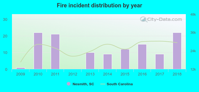 According to the data from the years 2009 - 2018 the average number of fire incidents per year is 12. The highest number of reported fires - 22 took place in 2010, and the least - 0 in 2012. The data has a growing trend.
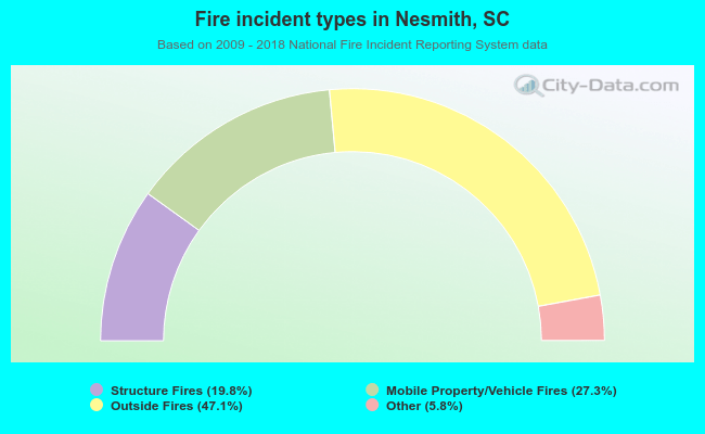 When looking into fire subcategories, the most incidents belonged to: Outside Fires (47.1%), and Mobile Property/Vehicle Fires (27.3%).
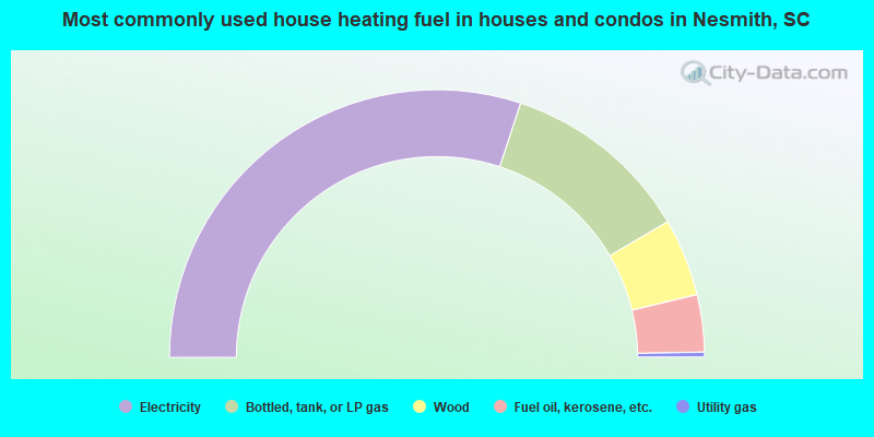
- 60.1%Electricity
- 22.9%Bottled, tank, or LP gas
- 9.4%Wood
- 6.9%Fuel oil, kerosene, etc.
- 0.6%Utility gas
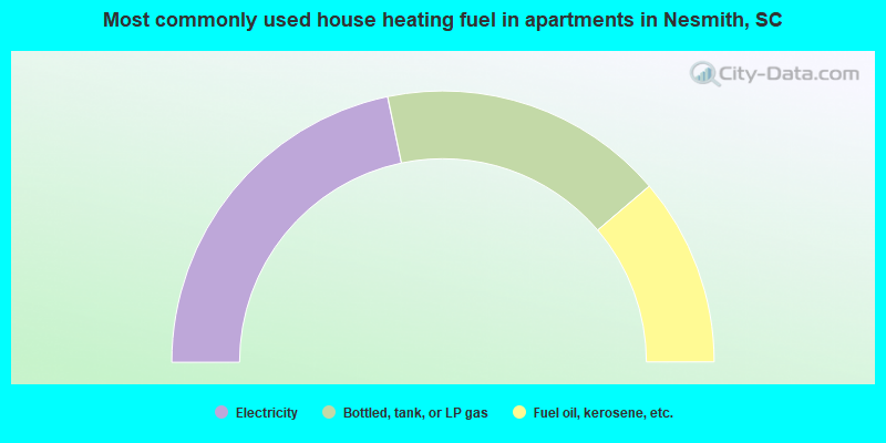
- 43.5%Electricity
- 34.1%Bottled, tank, or LP gas
- 22.5%Fuel oil, kerosene, etc.
Nesmith compared to South Carolina state average:
- Median household income below state average.
- Median house value significantly below state average.
- Black race population percentage above state average.
- Hispanic race population percentage significantly below state average.
- Foreign-born population percentage significantly below state average.
- Renting percentage below state average.
- Length of stay since moving in significantly above state average.
- Number of rooms per house significantly below state average.
- House age significantly below state average.
- Percentage of population with a bachelor's degree or higher significantly below state average.