New Bethlehem, Pennsylvania

New Bethlehem: Fall - along creek in New Bethlehem area

New Bethlehem: deep in the wood.with redbank creek in back ground
- add
your
Submit your own pictures of this borough and show them to the world
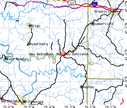
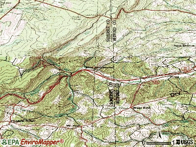
- OSM Map
- General Map
- Google Map
- MSN Map
Population change since 2000: -9.0%
 |
| Males: 470 | |
| Females: 492 |
| Median resident age: | 50.5 years |
| Pennsylvania median age: | 40.9 years |
Zip codes: 16242.
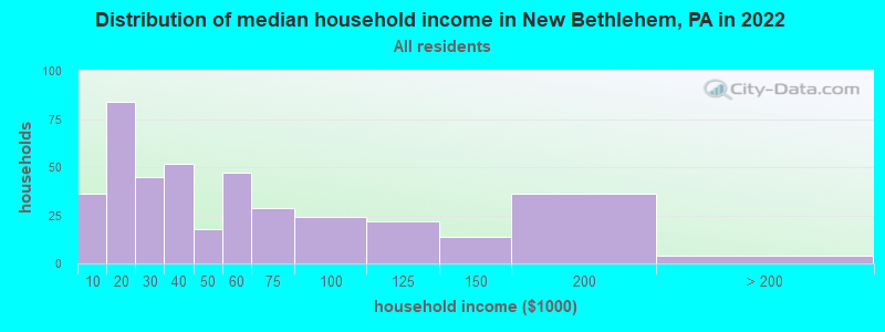
| New Bethlehem: | $35,426 |
| PA: | $71,798 |
Estimated per capita income in 2022: $27,683 (it was $17,796 in 2000)
New Bethlehem borough income, earnings, and wages data
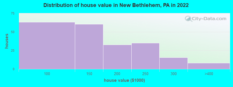
Estimated median house or condo value in 2022: $131,975 (it was $64,900 in 2000)
| New Bethlehem: | $131,975 |
| PA: | $245,500 |
Mean prices in 2022: all housing units: $132,967; detached houses: $131,667
Median gross rent in 2022: $625.
(29.4% for White Non-Hispanic residents, 18.2% for Black residents, 13.3% for Hispanic or Latino residents)
Detailed information about poverty and poor residents in New Bethlehem, PA
Compare current foreclosures near New Bethlehem, PA:
| Photo | Address | Area | Beds / Baths | Price | Details |
|---|---|---|---|---|---|

|
#1
Penn St
New Bethlehem, PA 16242
|
780 sq. feet
|
2 baths 4 beds |
$39,900
|
show details |

|
#2
Calhoun School Rd
New Bethlehem, PA 16242
|
- sq. feet
|
- baths - beds |
show details | |

|
#3
Penn St
New Bethlehem, PA 16242
|
560 sq. feet
|
- baths - beds |
show details | |

|
#4
Ridge Ave
Kittanning, PA 16201
|
1,088 sq. feet
|
1 baths 2 beds |
$36,654
|
show details |

|
#5
E Brady Rd
Kittanning, PA 16201
|
1,509 sq. feet
|
1 baths 3 beds |
$95,128
|
show details |

|
#6
Queenstown Rd
Karns City, PA 16041
|
1,092 sq. feet
|
1 baths 3 beds |
$68,547
|
show details |

|
#7
Main St
Corsica, PA 15829
|
1,268 sq. feet
|
1 baths 3 beds |
show details | |

|
#8
S Mckean St
Kittanning, PA 16201
|
2,244 sq. feet
|
1 baths 3 beds |
show details | |

|
#9
Bradys Bend Cemetery Rd
East Brady, PA 16028
|
1,680 sq. feet
|
1 baths 4 beds |
show details | |

|
#10
Hilliard Dr
Brookville, PA 15825
|
1,008 sq. feet
|
2 baths 4 beds |
show details |
| Photo | Address | Area | Beds / Baths | Price | Details |
|---|---|---|---|---|---|

|
#11
Water Tower Rd
Kittanning, PA 16201
|
1,282 sq. feet
|
1 baths 3 beds |
show details | |

|
#12
& 419 Red Mill Road
Kittanning, PA 16201
|
- sq. feet
|
- baths - beds |
$133,451
|
show details |

|
#13
Orr Ave
Kittanning, PA 16201
|
1,874 sq. feet
|
1 baths 3 beds |
show details | |

|
#14
North Ave
Kittanning, PA 16201
|
2,065 sq. feet
|
1 baths 3 beds |
show details | |

|
#15
Highland Ave
Kittanning, PA 16201
|
1,174 sq. feet
|
1 baths 2 beds |
show details | |

|
#16
N Mckean St
Kittanning, PA 16201
|
2,009 sq. feet
|
1 baths 3 beds |
show details | |

|
#17
Fifth Street
Sagamore, PA 16250
|
- sq. feet
|
- baths - beds |
$115,167
|
show details |

|
#18
Wray Plan Rd
Kittanning, PA 16201
|
- sq. feet
|
- baths - beds |
$77,323
|
show details |

|
#19
Franklin Ave
Kittanning, PA 16201
|
1,905 sq. feet
|
2 baths 3 beds |
show details | |

|
#20
Iron Works St
Kittanning, PA 16201
|
1,288 sq. feet
|
1 baths 3 beds |
show details |
| Photo | Address | Area | Beds / Baths | Price | Details |
|---|---|---|---|---|---|

|
#21
E Brady Rd
Cowansville, PA 16218
|
1,522 sq. feet
|
1 baths 4 beds |
show details | |

|
#22
Mcmillen Rd
Kittanning, PA 16201
|
1,488 sq. feet
|
2 baths 3 beds |
show details | |

|
#23
Stewartson Rd
Templeton, PA 16259
|
- sq. feet
|
- baths - beds |
$94,752
|
show details |

|
#24
E 1st Street
Rural Valley, PA 16249
|
- sq. feet
|
- baths - beds |
$60,784
|
show details |

|
#25
2nd St
East Brady, PA 16028
|
- sq. feet
|
- baths - beds |
show details | |

|
#26
Main St
Hawthorn, PA 16230
|
- sq. feet
|
- baths - beds |
show details | |

|
#27
Doc Walker Rd
Parker, PA 16049
|
1,022 sq. feet
|
- baths - beds |
show details | |

|
#28
Route 210 Hwy
Punxsutawney, PA 15767
|
- sq. feet
|
- baths - beds |
show details | |

|
#29
Lobaughhill Rd
Rimersburg, PA 16248
|
580 sq. feet
|
- baths - beds |
show details | |

|
#30
N Jefferson St Apt 5d
Kittanning, PA 16201
|
- sq. feet
|
- baths - beds |
show details |
| Photo | Address | Area | Beds / Baths | Price | Details |
|---|---|---|---|---|---|

|
#31
Route 68
Rimersburg, PA 16248
|
- sq. feet
|
- baths - beds |
show details | |

|
#32
Main St
Rimersburg, PA 16248
|
- sq. feet
|
- baths - beds |
show details | |

|
#33
E Main St
Dayton, PA 16222
|
- sq. feet
|
- baths - beds |
show details | |

|
#34
Burgoon Rd
Summerville, PA 15864
|
768 sq. feet
|
- baths - beds |
show details | |

|
#35
Curtinbottom Rd
Summerville, PA 15864
|
384 sq. feet
|
- baths - beds |
show details | |

|
#36
Perry Way
Punxsutawney, PA 15767
|
448 sq. feet
|
- baths - beds |
show details | |

|
#37
Mays Rd
Clarion, PA 16214
|
675 sq. feet
|
- baths - beds |
show details | |

|
#38
Route 36
Brookville, PA 15825
|
624 sq. feet
|
- baths - beds |
show details | |

|
#39
Washington St
Strattanville, PA 16258
|
- sq. feet
|
- baths - beds |
show details | |

|
#40
Robinwood Dr
Clarion, PA 16214
|
1,144 sq. feet
|
- baths - beds |
show details |
| Photo | Address | Area | Beds / Baths | Price | Details |
|---|---|---|---|---|---|

|
#41
E 1st St
Rural Valley, PA 16249
|
- sq. feet
|
- baths - beds |
show details | |

|
#42
Harrison St
Kittanning, PA 16201
|
- sq. feet
|
- baths - beds |
show details | |

|
#43
5th St
Sagamore, PA 16250
|
- sq. feet
|
- baths - beds |
show details | |

|
#44
Red Mill Rd
Kittanning, PA 16201
|
- sq. feet
|
- baths - beds |
show details | |

|
#45
Red Mill Rd
Kittanning, PA 16201
|
- sq. feet
|
- baths - beds |
show details | |

|
Check over 1 million property listings on Foreclosure.com!
|
browse all offers | |||


- 77291.6%White alone
- 192.3%Two or more races
- 172.0%Asian alone
- 151.8%Hispanic
- 101.2%Black alone
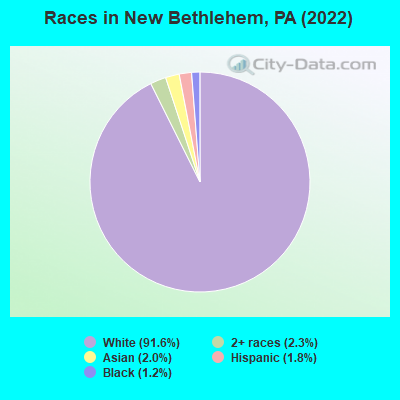
Races in New Bethlehem detailed stats: ancestries, foreign born residents, place of birth
According to our research of Pennsylvania and other state lists, there were 6 registered sex offenders living in New Bethlehem, Pennsylvania as of May 09, 2024.
The ratio of all residents to sex offenders in New Bethlehem is 165 to 1.
 Recent articles from our blog. Our writers, many of them Ph.D. graduates or candidates, create easy-to-read articles on a wide variety of topics.

 | New Bethlehem (15 replies) |
| Study into Route 28 expressway expansion to I-80 gets funding (83 replies) |
| Midrise towers in the Pittsburgh suburbs (38 replies) |
| Mayor Peduto Wants The Syrian Refugees To Come To Pittsburgh (341 replies) |
| Cranberry Is So Ugly (199 replies) |
| Route 28: How will it be 4 lanes all the way to Kittanning? (65 replies) |
Latest news from New Bethlehem, PA collected exclusively by city-data.com from local newspapers, TV, and radio stations
Ancestries: German (22.1%), American (16.3%), Irish (14.9%), English (12.3%), Italian (6.2%), Scotch-Irish (4.7%).
Current Local Time: EST time zone
Incorporated in 1853
Elevation: 1072 feet
Land area: 0.48 square miles.
Population density: 2,019 people per square mile (low).
27 residents are foreign born (1.9% Asia, 0.4% Africa).
| This borough: | 3.2% |
| Pennsylvania: | 7.3% |
Median real estate property taxes paid for housing units with mortgages in 2022: $1,253 (0.9%)
Median real estate property taxes paid for housing units with no mortgage in 2022: $1,245 (0.9%)
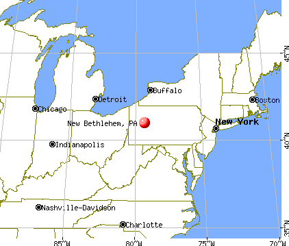
Nearest city with pop. 50,000+: Pittsburgh, PA  (51.6 miles , pop. 334,563).
Nearest city with pop. 1,000,000+: Philadelphia, PA (230.9 miles , pop. 1,517,550).
Nearest cities:
), ), ), ), )Latitude: 41.00 N, Longitude: 79.33 W
Area code: 814
| Here: | 3.6% |
| Pennsylvania: | 2.9% |
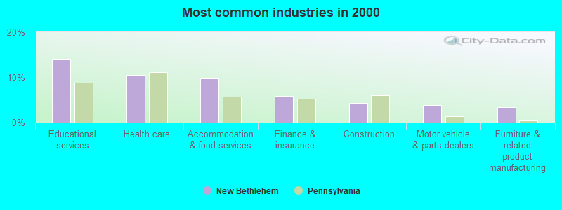
- Educational services (13.9%)
- Health care (10.5%)
- Accommodation & food services (9.8%)
- Finance & insurance (5.9%)
- Construction (4.4%)
- Motor vehicle & parts dealers (3.9%)
- Furniture & related product manufacturing (3.4%)
- Educational services (10.6%)
- Accommodation & food services (8.4%)
- Construction (7.1%)
- Motor vehicle & parts dealers (6.2%)
- Furniture & related product manufacturing (6.2%)
- Wood products (5.3%)
- Truck transportation (4.9%)
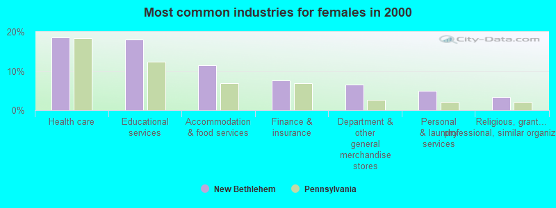
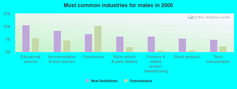
- Health care (18.6%)
- Educational services (18.0%)
- Accommodation & food services (11.5%)
- Finance & insurance (7.7%)
- Department & other general merchandise stores (6.6%)
- Personal & laundry services (4.9%)
- Religious, grantmaking, civic, professional, similar organizations (3.3%)
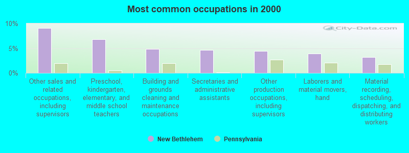
- Other sales and related occupations, including supervisors (9.0%)
- Preschool, kindergarten, elementary, and middle school teachers (6.8%)
- Building and grounds cleaning and maintenance occupations (4.9%)
- Secretaries and administrative assistants (4.6%)
- Other production occupations, including supervisors (4.4%)
- Laborers and material movers, hand (3.9%)
- Material recording, scheduling, dispatching, and distributing workers (3.2%)

- Other sales and related occupations, including supervisors (9.3%)
- Laborers and material movers, hand (6.6%)
- Other production occupations, including supervisors (6.2%)
- Other material moving workers, except laborers (5.3%)
- Preschool, kindergarten, elementary, and middle school teachers (4.9%)
- Driver/sales workers and truck drivers (4.4%)
- Electrical equipment mechanics and other installation, maintenance, and repair workers, including supervisors (3.5%)
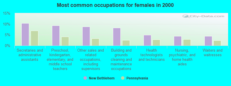
- Secretaries and administrative assistants (10.4%)
- Preschool, kindergarten, elementary, and middle school teachers (9.3%)
- Other sales and related occupations, including supervisors (8.7%)
- Building and grounds cleaning and maintenance occupations (8.2%)
- Health technologists and technicians (4.9%)
- Nursing, psychiatric, and home health aides (4.4%)
- Waiters and waitresses (4.4%)
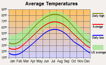
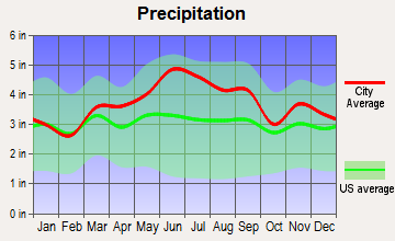
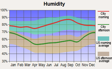
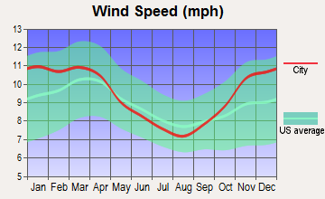
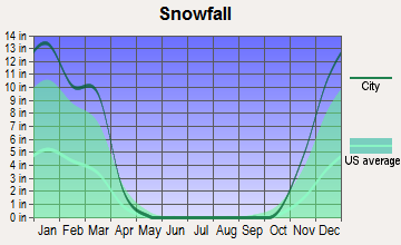
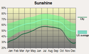
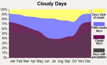
Average climate in New Bethlehem, Pennsylvania
Based on data reported by over 4,000 weather stations
|
|

(lower is better)
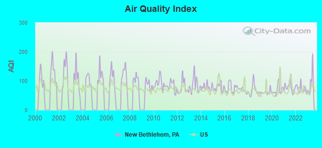
Air Quality Index (AQI) level in 2023 was 89.5. This is worse than average.
| City: | 89.5 |
| U.S.: | 72.6 |
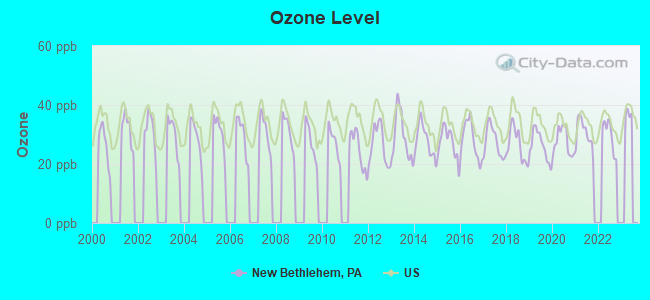
Ozone [ppb] level in 2022 was 29.8. This is about average. Closest monitor was 17.9 miles away from the city center.
| City: | 29.8 |
| U.S.: | 33.3 |
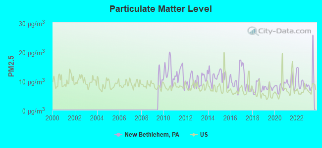
Particulate Matter (PM2.5) [µg/m3] level in 2023 was 10.6. This is worse than average. Closest monitor was 17.9 miles away from the city center.
| City: | 10.6 |
| U.S.: | 8.1 |
Tornado activity:
New Bethlehem-area historical tornado activity is near Pennsylvania state average. It is 18% smaller than the overall U.S. average.
On 5/31/1985, a category F4 (max. wind speeds 207-260 mph) tornado 30.4 miles away from the New Bethlehem borough center killed 16 people and injured 125 people and caused between $5,000,000 and $50,000,000 in damages.
On 6/3/1980, a category F4 tornado 30.6 miles away from the borough center injured 140 people and caused between $50,000,000 and $500,000,000 in damages.
Earthquake activity:
New Bethlehem-area historical earthquake activity is significantly above Pennsylvania state average. It is 60% smaller than the overall U.S. average.On 9/25/1998 at 19:52:52, a magnitude 5.2 (4.8 MB, 4.3 MS, 5.2 LG, 4.5 MW, Depth: 3.1 mi, Class: Moderate, Intensity: VI - VII) earthquake occurred 64.9 miles away from New Bethlehem center
On 8/23/2011 at 17:51:04, a magnitude 5.8 (5.8 MW, Depth: 3.7 mi) earthquake occurred 226.6 miles away from the city center
On 1/31/1986 at 16:46:43, a magnitude 5.0 (5.0 MB) earthquake occurred 103.7 miles away from the city center
On 1/16/1994 at 01:49:16, a magnitude 4.6 (4.6 MB, 4.6 LG, Depth: 3.1 mi, Class: Light, Intensity: IV - V) earthquake occurred 179.0 miles away from the city center
On 12/31/2011 at 20:05:01, a magnitude 4.0 (4.0 ML, Depth: 3.1 mi) earthquake occurred 71.1 miles away from the city center
On 10/7/1983 at 10:18:46, a magnitude 5.3 (5.1 MB, 5.3 LG, 5.1 ML) earthquake occurred 326.1 miles away from the city center
Magnitude types: regional Lg-wave magnitude (LG), body-wave magnitude (MB), local magnitude (ML), surface-wave magnitude (MS), moment magnitude (MW)
Natural disasters:
The number of natural disasters in Clarion County (12) is smaller than the US average (15).Major Disasters (Presidential) Declared: 8
Emergencies Declared: 4
Causes of natural disasters: Floods: 5, Storms: 3, Hurricanes: 2, Snowfall: 1, Snowstorm: 1, Tornado: 1, Tropical Depression: 1, Tropical Storm: 1, Winter Storm: 1, Other: 1 (Note: some incidents may be assigned to more than one category).
Colleges/universities with over 2000 students nearest to New Bethlehem:
- Clarion University of Pennsylvania (about 15 miles; Clarion, PA; Full-time enrollment: 5,771)
- Indiana University of Pennsylvania-Main Campus (about 29 miles; Indiana, PA; FT enrollment: 14,471)
- Butler County Community College (about 33 miles; Butler, PA; FT enrollment: 2,518)
- Slippery Rock University of Pennsylvania (about 38 miles; Slippery Rock, PA; FT enrollment: 8,424)
- Wyo Tech-Blairsville (about 39 miles; Blairsville, PA; FT enrollment: 2,602)
- Grove City College (about 41 miles; Grove City, PA; FT enrollment: 2,560)
- Seton Hill University (about 50 miles; Greensburg, PA; FT enrollment: 2,167)
Public high school in New Bethlehem:
- REDBANK VALLEY HS (Students: 642, Location: 910 BROAD ST, Grades: 7-12)
Private high schools in New Bethlehem:
- NEW BETHLEHEM MENNONITE SCHOOL (Students: 32, Location: PACKING RD (OFF OF S REIDSBURG RD), Grades: KG-9)
- NEW BETHLEHEM WESLEYAN METHODIST SCHOOL (Students: 16, Location: 140 CALHOUN SCHOOL RD, Grades: 2-12)
Public elementary/middle school in New Bethlehem:
User-submitted facts and corrections:
- The New Bethlehem Free Public Library is located at 720 Broad Street. It was moved.
Points of interest:
Notable location: New Bethlehem Fire Company 1 (A). Display/hide its location on the map
Streams, rivers, and creeks: Leisure Run (A). Display/hide its location on the map
Birthplace of: Ossee Schreckengost - Baseball player.
Drinking water stations with addresses in New Bethlehem and their reported violations in the past:
PINEY MEADOWS CAMPGROUND (Population served: 100, Groundwater):Past health violations:PUTNEYVILLE STORE (Population served: 100, Groundwater):
- MCL, Monthly (TCR) - Between APR-2006 and JUN-2006, Contaminant: Coliform. Follow-up actions: St Public Notif requested (FEB-20-2007), St Public Notif received (FEB-20-2007), St Compliance achieved (FEB-20-2007), St Formal NOV issued (FEB-20-2007)
Past health violations:MAHONING CREEK LAKE (Population served: 75, Groundwater):Past monitoring violations:
- MCL, Monthly (TCR) - Between JAN-2013 and MAR-2013, Contaminant: Coliform. Follow-up actions: St Violation/Reminder Notice (APR-01-2013), St Compliance Meeting conducted (APR-01-2013), St Tech Assistance Visit (APR-01-2013), St Compliance achieved (APR-01-2013), St Public Notif received (APR-01-2013)
- MCL, Monthly (TCR) - Between OCT-2012 and DEC-2012, Contaminant: Coliform. Follow-up actions: St Public Notif received (APR-01-2013), St Compliance achieved (APR-01-2013)
- Monitoring, Source Water (GWR) - Between FEB-22-2013 and MAR-22-2013, Contaminant: E. COLI. Follow-up actions: St Compliance achieved (APR-01-2013), St Violation/Reminder Notice (APR-01-2013)
- 2 routine major monitoring violations
Past monitoring violations:
- Monitoring, Source Water (GWR) - Between MAY-27-2011 and JUN-27-2011, Contaminant: E. COLI. Follow-up actions: St Violation/Reminder Notice (SEP-22-2011), St Compliance achieved (SEP-22-2011)
- One minor monitoring violation
- 3 regular monitoring violations
| This borough: | 2.1 people |
| Pennsylvania: | 2.5 people |
| This borough: | 53.1% |
| Whole state: | 65.0% |
| This borough: | 5.1% |
| Whole state: | 6.6% |
Likely homosexual households (counted as self-reported same-sex unmarried-partner households)
- Lesbian couples: 0.0% of all households
- Gay men: 0.2% of all households
Banks with branches in New Bethlehem (2011 data):
- Clarion County Community Bank: New Bethlehem Branch at 308 Broad Street, branch established on 2004/01/07. Info updated 2010/08/30: Bank assets: $120.3 mil, Deposits: $107.9 mil, headquarters in Clarion, PA, positive income, Mortgage Lending Specialization, 3 total offices
- S&T Bank: New Bethlehem Branch at 628 Broad Street, branch established on 1981/09/17. Info updated 2012/03/14: Bank assets: $4,099.9 mil, Deposits: $3,349.5 mil, headquarters in Indiana, PA, positive income, Commercial Lending Specialization, 60 total offices, Holding Company: S & T Bancorp, Inc.
- First United National Bank: New Bethlehem Branch at 706 Broad Street, branch established on 1928/01/01. Info updated 2006/11/03: Bank assets: $243.8 mil, Deposits: $224.0 mil, headquarters in Fryburg, PA, positive income, 6 total offices, Holding Company: Fryburg Banking Company, Inc.
- Northwest Savings Bank: New Bethlehem Branch at 301 Broad Street, branch established on 1954/07/12. Info updated 2009/11/23: Bank assets: $7,975.9 mil, Deposits: $5,985.6 mil, headquarters in Warren, PA, positive income, Mortgage Lending Specialization, 172 total offices
For population 15 years and over in New Bethlehem:
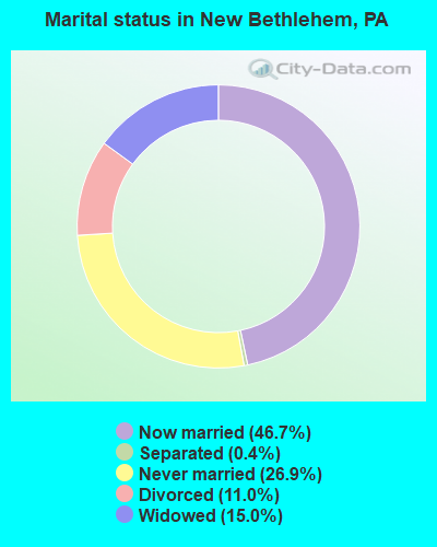
- Never married: 26.9%
- Now married: 46.7%
- Separated: 0.4%
- Widowed: 15.0%
- Divorced: 11.0%
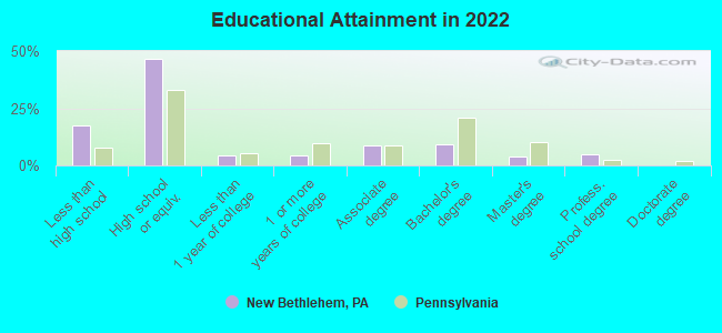
For population 25 years and over in New Bethlehem:
- High school or higher: 81.5%
- Bachelor's degree or higher: 17.7%
- Graduate or professional degree: 8.7%
- Unemployed: 4.7%
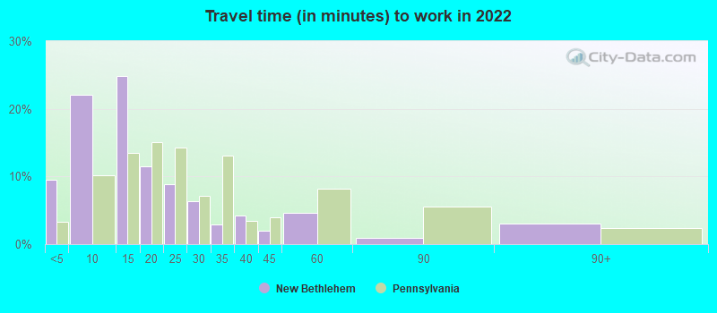
- Mean travel time to work (commute): 25.0 minutes
| Here: | 12.7 |
| Pennsylvania average: | 11.4 |
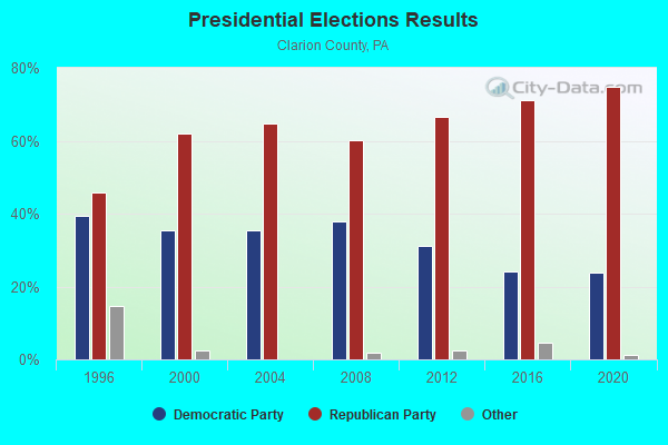
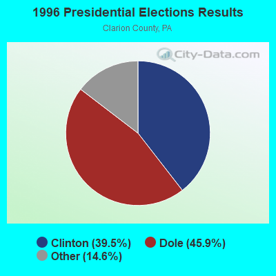
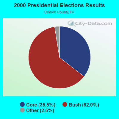
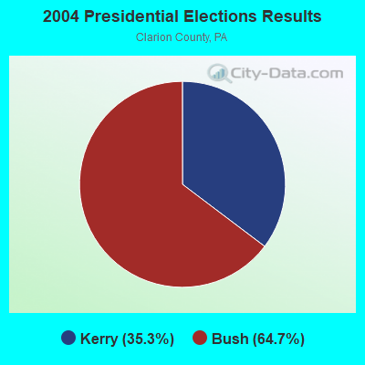
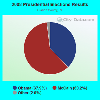
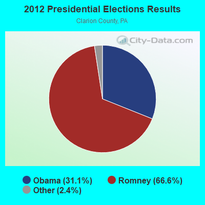
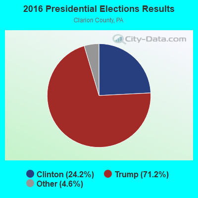
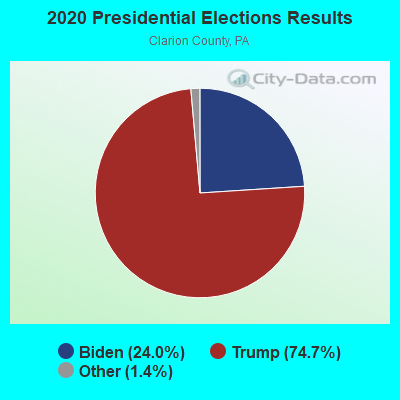
Graphs represent county-level data. Detailed 2008 Election Results
Religion statistics for New Bethlehem, PA (based on Clarion County data)
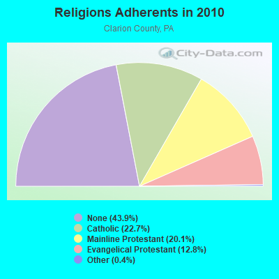

| Religion | Adherents | Congregations |
|---|---|---|
| Catholic | 9,079 | 8 |
| Mainline Protestant | 8,048 | 57 |
| Evangelical Protestant | 5,121 | 42 |
| Other | 166 | 4 |
| None | 17,574 | - |
Food Environment Statistics:
| This county: | 3.50 / 10,000 pop. |
| State: | 2.04 / 10,000 pop. |
| Clarion County: | 0.25 / 10,000 pop. |
| Pennsylvania: | 0.09 / 10,000 pop. |
| Here: | 0.50 / 10,000 pop. |
| Pennsylvania: | 0.88 / 10,000 pop. |
| Here: | 5.00 / 10,000 pop. |
| Pennsylvania: | 2.52 / 10,000 pop. |
| This county: | 10.75 / 10,000 pop. |
| State: | 7.12 / 10,000 pop. |
| Here: | 8.5% |
| Pennsylvania: | 9.1% |
| Clarion County: | 28.3% |
| Pennsylvania: | 27.2% |
| Clarion County: | 8.9% |
| Pennsylvania: | 11.5% |
Health and Nutrition:
| New Bethlehem: | 48.2% |
| State: | 50.2% |
| New Bethlehem: | 45.8% |
| State: | 47.1% |
| New Bethlehem: | 29.2 |
| State: | 28.7 |
| This city: | 15.7% |
| Pennsylvania: | 20.8% |
| New Bethlehem: | 9.8% |
| State: | 10.9% |
| New Bethlehem: | 6.5 |
| Pennsylvania: | 6.8 |
| Here: | 31.6% |
| Pennsylvania: | 34.3% |
| New Bethlehem: | 57.5% |
| Pennsylvania: | 56.2% |
| Here: | 84.6% |
| Pennsylvania: | 78.3% |
More about Health and Nutrition of New Bethlehem, PA Residents
| Local government employment and payroll (March 2022) | |||||
| Function | Full-time employees | Monthly full-time payroll | Average yearly full-time wage | Part-time employees | Monthly part-time payroll |
|---|---|---|---|---|---|
| Streets and Highways | 2 | $8,269 | $49,614 | 1 | $189 |
| Police Protection - Officers | 2 | $6,893 | $41,358 | 2 | $739 |
| Financial Administration | 0 | $0 | 1 | $792 | |
| Police - Other | 0 | $0 | 2 | $2,800 | |
| Totals for Government | 4 | $15,162 | $45,486 | 6 | $4,520 |
New Bethlehem government finances - Expenditure in 2017 (per resident):
- Current Operations - Police Protection: $226,000 ($234.93)
Regular Highways: $155,000 ($161.12)
General - Other: $118,000 ($122.66)
Central Staff Services: $52,000 ($54.05)
Solid Waste Management: $36,000 ($37.42)
Local Fire Protection: $18,000 ($18.71)
Miscellaneous Commercial Activities - Other: $6,000 ($6.24)
Protective Inspection and Regulation - Other: $2,000 ($2.08)
Parks and Recreation: $1,000 ($1.04)
- General - Interest on Debt: $1,000 ($1.04)
New Bethlehem government finances - Revenue in 2017 (per resident):
- Charges - Other: $155,000 ($161.12)
Solid Waste Management: $70,000 ($72.77)
Parking Facilities: $1,000 ($1.04)
- Local Intergovernmental - Other: $25,000 ($25.99)
- Miscellaneous - Fines and Forfeits: $12,000 ($12.47)
Donations From Private Sources: $8,000 ($8.32)
- State Intergovernmental - Other: $78,000 ($81.08)
- Tax - Property: $208,000 ($216.22)
Individual Income: $71,000 ($73.80)
Occupation and Business License - Other: $30,000 ($31.19)
Documentary and Stock Transfer: $14,000 ($14.55)
Public Utility License: $3,000 ($3.12)
New Bethlehem government finances - Debt in 2017 (per resident):
- Long Term Debt - Retired Unspecified Public Purpose: $35,000 ($36.38)
Beginning Outstanding - Unspecified Public Purpose: $35,000 ($36.38)
New Bethlehem government finances - Cash and Securities in 2017 (per resident):
- Other Funds - Cash and Securities: $381,000 ($396.05)
| Businesses in New Bethlehem, PA | ||||
| Name | Count | Name | Count | |
|---|---|---|---|---|
| Burger King | 1 | La-Z-Boy | 1 | |
| Chevrolet | 1 | MasterBrand Cabinets | 2 | |
| Goodwill | 2 | Rite Aid | 1 | |
| H&R Block | 1 | Subway | 1 | |
Strongest AM radio stations in New Bethlehem:
- KDKA (1020 AM; 50 kW; PITTSBURGH, PA; Owner: INFINITY BROADCASTING OPERATIONS, INC.)
- WECZ (1540 AM; daytime; 5 kW; PUNXSUTAWNEY, PA)
- WCCS (1160 AM; 10 kW; HOMER CITY, PA; Owner: RENDA RADIO, INC.)
- WAVL (910 AM; 5 kW; APOLLO, PA; Owner: EVANGEL HEIGHTS ASSEMBLY OF GOD)
- WWVA (1170 AM; 53 kW; WHEELING, WV; Owner: CAPSTAR TX LIMITED PARTNERSHIP)
- WCED (1420 AM; 5 kW; DU BOIS, PA; Owner: VOX ALLEGANY, LLC)
- WWCH (1300 AM; 1 kW; CLARION, PA; Owner: CLARION COUNTY BROADCASTING CORP.)
- WKNR (850 AM; 50 kW; CLEVELAND, OH; Owner: CARON BROADCASTING, INC.)
- WTAM (1100 AM; 50 kW; CLEVELAND, OH; Owner: JACOR BROADCASTING CORPORATION)
- WLYE (850 AM; 10 kW; JOHNSTOWN, PA; Owner: FOREVER OF JOHNSTOWN, INC.)
- WKHB (620 AM; 6 kW; IRWIN, PA; Owner: BROADCAST COMMUNICATIONS, INC.)
- WHK (1220 AM; 50 kW; CLEVELAND, OH; Owner: CARON BROADCASTING, INC.)
- WPIT (730 AM; 5 kW; PITTSBURGH, PA; Owner: PENNSYLVANIA MEDIA ASSOCIATES, INC.)
Strongest FM radio stations in New Bethlehem:
- WYTR (103.3 FM; BROOKVILLE, PA; Owner: RENDA RADIO, INC.)
- WMKX (105.5 FM; BROOKVILLE, PA; Owner: STRATTAN BROADCASTING, INC.)
- WCUC-FM (91.7 FM; CLARION, PA; Owner: CLARION STATE COLLEGE)
- WZPT (100.7 FM; NEW KENSINGTON, PA; Owner: INFINITY RADIO SUBSIDIARY OPERATIONS INC.)
- WQEJ (89.7 FM; JOHNSTOWN, PA; Owner: WQED MULTIMEDIA)
- WPXZ-FM (104.1 FM; PUNXSUTAWNEY, PA; Owner: RENDA RADIO, INC.)
- WOKW (102.9 FM; CURWENSVILLE, PA; Owner: RAYMARK BROADCASTING CO., INC.)
- WCCR (92.7 FM; CLARION, PA; Owner: CLARION COUNTY BROADCASTING CORP.)
- WQYX (93.1 FM; CLEARFIELD, PA; Owner: CLEARFIELD BROADCASTERS, INC.)
- WOWQ (102.1 FM; DU BOIS, PA; Owner: FIRST MEDIA RADIO, LLC)
- WDSN (106.5 FM; REYNOLDSVILLE, PA; Owner: PRIORITY COMMUNICATIONS, INC.)
TV broadcast stations around New Bethlehem:
- W25AX (Channel 25; KITTANNING, PA; Owner: TURNPIKE TELEVISION)
- W45BT (Channel 45; BROOKVILLE, PA; Owner: CORNERSTONE TELEVISION, INC.)
- WLLS-LP (Channel 49; INDIANA, PA; Owner: LARRY L. SCHRECONGOST)
- W60BL (Channel 60; BUTLER, PA; Owner: TURNPIKE TELEVISION)
- WBOA-LP (Channel 64; KITTANNING, PA; Owner: ABACUS TELEVISION)
New Bethlehem fatal accident list:
Nov 20, 2002 08:20 AM, Sr-66, Lat: 41.003548, Lon: -79.331462, Vehicles: 1, Persons: 1, Fatalities: 1
Jun 1, 1999 12:45 AM, Sr-66, Lat: 41.003548, Lon: -79.331462, Vehicles: 1, Persons: 1, Fatalities: 1
Jun 27, 1978 04:00 PM, Vehicles: 1, Persons: 2, Fatalities: 1
- National Bridge Inventory (NBI) Statistics
- 4Number of bridges
- 10ft / 3.3mTotal length
- $334,000Total costs
- 9,143Total average daily traffic
- 885Total average daily truck traffic
- 12,474Total future (year 2032) average daily traffic
FCC Registered Cell Phone Towers:
2 (See the full list of FCC Registered Cell Phone Towers in New Bethlehem)FCC Registered Antenna Towers:
32 (See the full list of FCC Registered Antenna Towers)FCC Registered Broadcast Land Mobile Towers:
8 (See the full list of FCC Registered Broadcast Land Mobile Towers in New Bethlehem, PA)FCC Registered Microwave Towers:
3- ASR1026711, 1/4 Mile E Of I/S Rt. 839 & Township Rd. 617 (New Bethlehem) (Lat: 40.992278 Lon: -79.317972), Type: Gtower, Structure height: 121.9 m, Overall height: 127.7 m, Call Sign: WQQX650,
Assigned Frequencies: 6093.45 MHz, 6123.10 MHz, Grant Date: 03/20/2013, Expiration Date: 03/20/2023, Cancellation Date: 01/03/2022, Certifier: Ido M Rosen, Registrant: Wireless Internetwork, LLC, 55 East 52nd Street, New York, NY 10055, Phone: (682) 429-1900, Email:
- Cottage Hill, 2-198 Ask Ln (Lat: 41.020222 Lon: -79.347806), Type: Tank, Structure height: 61 m, Overall height: 62 m, Call Sign: WRJW955,
Assigned Frequencies: 10915.0 MHz, 6212.06 MHz, 10915.0 MHz, 6212.06 MHz, 10915.0 MHz, 6212.06 MHz, 10915.0 MHz, 6212.06 MHz, 10915.0 MHz, 6212.06 MHz... (+6 more), Grant Date: 11/12/2020, Expiration Date: 11/12/2030, Certifier: Jeff Smathers, Registrant: Intelpath, Hinsdale, IL 60522, Phone: (312) 841-9188, Email:
- STATION, 4 Mi N Of (Lat: 41.058944 Lon: -79.339194), Overall height: 61 m, Call Sign: KZK36,
Assigned Frequencies: 6745.00 MHz, 6785.00 MHz, Grant Date: 08/24/2000, Expiration Date: 10/03/2010, Cancellation Date: 11/22/2002, Certifier: Steven F Lux, Registrant: Fehlc, Inc., 76 South Main Street, Akron, OH 44308, Phone: (330) 384-5498, Fax: (330) 761-7203, Email:
FCC Registered Paging Towers:
1- East Side Of Rt. 66, 0.2 Miles Sw Of Distant Township (Lat: 40.961722 Lon: -79.355306), Call Sign: KNKI989, Licensee ID: L00001605,
Assigned Frequencies: 152.630 MHz, Expiration Date: 04/01/1999, Cancellation Date: 06/05/1999, Registrant: Dubois Mobile Telephone Company, Inc., . 7214 Bona Vista Ct., Springfield, VA 22150
FCC Registered Amateur Radio Licenses:
20 (See the full list of FCC Registered Amateur Radio Licenses in New Bethlehem)2003 - 2018 National Fire Incident Reporting System (NFIRS) incidents
- Fire incident types reported to NFIRS in New Bethlehem, PA
- 14269.3%Structure Fires
- 3014.6%Outside Fires
- 188.8%Other
- 157.3%Mobile Property/Vehicle Fires
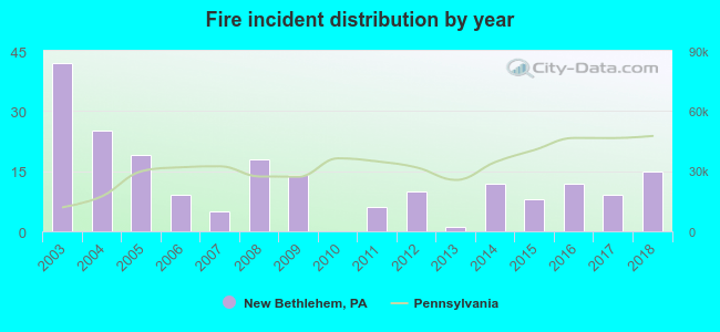 Based on the data from the years 2003 - 2018 the average number of fire incidents per year is 13. The highest number of reported fire incidents - 42 took place in 2003, and the least - 0 in 2010. The data has a dropping trend.
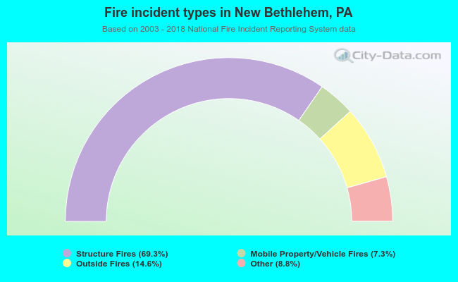 When looking into fire subcategories, the most incidents belonged to: Structure Fires (69.3%), and Outside Fires (14.6%).
| Most common first names in New Bethlehem, PA among deceased individuals | ||
| Name | Count | Lived (average) |
|---|---|---|
| William | 51 | 75.6 years |
| John | 49 | 73.8 years |
| James | 44 | 75.7 years |
| Mary | 42 | 80.6 years |
| Charles | 41 | 76.6 years |
| Robert | 37 | 74.2 years |
| Helen | 33 | 79.9 years |
| George | 26 | 78.5 years |
| Paul | 25 | 74.3 years |
| Harry | 22 | 77.8 years |
| Most common last names in New Bethlehem, PA among deceased individuals | ||
| Last name | Count | Lived (average) |
|---|---|---|
| Smith | 44 | 78.2 years |
| Shaffer | 25 | 75.5 years |
| Shreckengost | 23 | 79.2 years |
| Schreckengos | 21 | 73.2 years |
| Hetrick | 19 | 79.4 years |
| Bowersox | 17 | 79.1 years |
| Bish | 17 | 81.9 years |
| Shumaker | 15 | 75.7 years |
| Brown | 14 | 80.6 years |
| Anthony | 14 | 76.3 years |
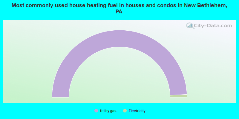
- 98.7%Utility gas
- 1.3%Electricity
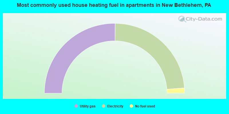
- 50.3%Utility gas
- 47.3%Electricity
- 2.4%No fuel used
New Bethlehem compared to Pennsylvania state average:
- Median household income below state average.
- Median house value below state average.
- Unemployed percentage significantly below state average.
- Black race population percentage significantly below state average.
- Hispanic race population percentage significantly below state average.
- Foreign-born population percentage significantly below state average.
- Renting percentage above state average.
- Length of stay since moving in significantly above state average.
- Institutionalized population percentage above state average.
- Number of college students significantly below state average.

|
Total of 8 patent applications in 2008-2024.