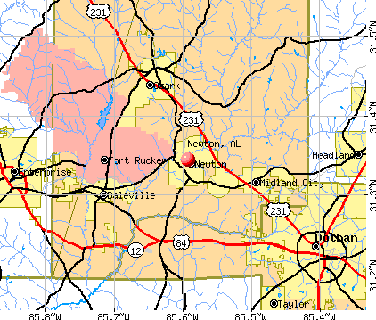
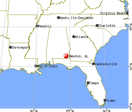
Newton, Alabama
Submit your own pictures of this town and show them to the world
- OSM Map
- General Map
- Google Map
- MSN Map
Population change since 2000: -4.9%
 |
| Males: 805 | |
| Females: 819 |
| Median resident age: | 44.2 years |
| Alabama median age: | 39.6 years |
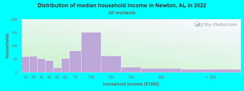
| Newton: | $64,367 |
| AL: | $59,674 |
Estimated per capita income in 2022: $26,736 (it was $15,263 in 2000)
Newton town income, earnings, and wages data
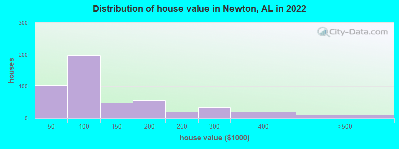
Estimated median house or condo value in 2022: $99,554 (it was $52,000 in 2000)
| Newton: | $99,554 |
| AL: | $200,900 |
Mean prices in 2022: all housing units: $124,241; detached houses: $144,621; mobile homes: $41,518
Median gross rent in 2022: $646.
(13.1% for White Non-Hispanic residents, 24.9% for Black residents, 28.0% for two or more races residents)
Detailed information about poverty and poor residents in Newton, AL

Compare current foreclosures in Newton, AL:
| Photo | Address | Area | Beds / Baths | Price | Details |
|---|---|---|---|---|---|

|
#1
S College St
Newton, AL 36352
|
1,594 sq. feet
|
1 baths 2 beds |
show details | |

|
#2
Jones Rd
Newton, AL 36352
|
2,110 sq. feet
|
2 baths 3 beds |
show details | |

|
#3
Fortner St
Newton, AL 36352
|
2,896 sq. feet
|
2 baths 4 beds |
show details | |

|
#4
Wicksburg Rd
Newton, AL 36352
|
1,828 sq. feet
|
2 baths 3 beds |
show details | |

|
#5
Winslette Rd
Newton, AL 36352
|
448 sq. feet
|
1 baths 1 beds |
show details | |

|
#6
Hubbard Rd
Newton, AL 36352
|
1,075 sq. feet
|
1 baths 3 beds |
show details | |

|
#7
W Hwy 84
Newton, AL 36352
|
1,128 sq. feet
|
1 baths 2 beds |
show details | |

|
#8
Sherwood Trl
Newton, AL 36352
|
1,637 sq. feet
|
1 baths 3 beds |
show details | |

|
#9
Bully Rd
Newton, AL 36352
|
1,506 sq. feet
|
2 baths 3 beds |
show details | |

|
#10
Winslette Rd
Newton, AL 36352
|
1,438 sq. feet
|
2 baths 3 beds |
show details |
| Photo | Address | Area | Beds / Baths | Price | Details |
|---|---|---|---|---|---|

|
#11
Laura Ln
Newton, AL 36352
|
1,792 sq. feet
|
- baths - beds |
show details | |

|
#12
Sherwood Trl
Newton, AL 36352
|
1,248 sq. feet
|
- baths - beds |
show details | |

|
#13
Lonnie Watson Rd
Newton, AL 36352
|
- sq. feet
|
- baths - beds |
show details | |

|
#14
Sanders Rd
Newton, AL 36352
|
- sq. feet
|
- baths - beds |
show details | |

|
#15
S College St
Newton, AL 36352
|
- sq. feet
|
- baths - beds |
show details | |

|
#16
N County Road 69
Newton, AL 36352
|
- sq. feet
|
- baths - beds |
show details | |

|
#17
Magnolia Ln
Newton, AL 36352
|
- sq. feet
|
- baths - beds |
show details | |

|
#18
Trista Ln
Newton, AL 36352
|
- sq. feet
|
- baths - beds |
show details | |

|
#19
Killebrew St
Newton, AL 36352
|
- sq. feet
|
- baths - beds |
show details | |

|
#20
Corbin Rd
Newton, AL 36352
|
- sq. feet
|
- baths - beds |
show details |
| Photo | Address | Area | Beds / Baths | Price | Details |
|---|---|---|---|---|---|

|
#21
County Road 31
Newton, AL 36352
|
- sq. feet
|
- baths - beds |
show details | |

|
#22
Windmill Rd
Newton, AL 36352
|
- sq. feet
|
- baths - beds |
show details | |

|
#23
Hartford St
Newton, AL 36352
|
- sq. feet
|
- baths - beds |
show details | |

|
#24
Wicksburg Rd
Newton, AL 36352
|
- sq. feet
|
- baths - beds |
show details | |

|
#25
Adkinson Rd
Newton, AL 36352
|
- sq. feet
|
- baths - beds |
show details | |

|
#26
Knight Cir
Newton, AL 36352
|
- sq. feet
|
- baths - beds |
show details | |

|
#27
S State Highway 123
Newton, AL 36352
|
- sq. feet
|
- baths - beds |
show details | |

|
#28
Spring St
Newton, AL 36352
|
- sq. feet
|
- baths - beds |
show details | |

|
#29
Oates Dr
Newton, AL 36352
|
- sq. feet
|
- baths - beds |
show details | |

|
#30
Hubbard Rd
Newton, AL 36352
|
2,128 sq. feet
|
- baths - beds |
show details |
| Photo | Address | Area | Beds / Baths | Price | Details |
|---|---|---|---|---|---|

|
#31
Stanford Hill Rd
Newton, AL 36352
|
2,018 sq. feet
|
- baths - beds |
show details | |

|
#32
Market Rd Lot 2
Newton, AL 36352
|
- sq. feet
|
- baths - beds |
show details | |

|
#33
Sandbed Rd
Newton, AL 36352
|
- sq. feet
|
- baths - beds |
show details | |

|
#34
S State Highway 123
Newton, AL 36352
|
- sq. feet
|
- baths - beds |
show details | |

|
#35
Callaway St
Newton, AL 36352
|
- sq. feet
|
- baths - beds |
show details | |

|
#36
Hubbard Rd
Newton, AL 36352
|
1,680 sq. feet
|
- baths - beds |
show details | |

|
#37
S Highway 123
Newton, AL 36352
|
- sq. feet
|
- baths - beds |
show details | |

|
#38
Laura Ln
Newton, AL 36352
|
1,344 sq. feet
|
- baths - beds |
show details | |

|
#39
Edna St
Newton, AL 36352
|
- sq. feet
|
- baths - beds |
show details | |

|
#40
Cumbie Rd
Newton, AL 36352
|
- sq. feet
|
- baths - beds |
show details |
| Photo | Address | Area | Beds / Baths | Price | Details |
|---|---|---|---|---|---|

|
Check over 1 million property listings on Foreclosure.com!
|
browse all offers | |||
| Photo | Address | Area | Beds / Baths | Price | Details |
|---|


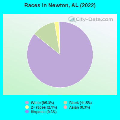
- 1,31585.3%White alone
- 17711.5%Black alone
- 322.1%Two or more races
- 40.3%Asian alone
- 40.3%Hispanic
According to our research of Alabama and other state lists, there were 20 registered sex offenders living in Newton, Alabama as of May 15, 2024.
The ratio of all residents to sex offenders in Newton is 76 to 1.
Type |
2009 |
2010 |
2011 |
2012 |
2013 |
2014 |
2015 |
2016 |
2017 |
2018 |
2019 |
2020 |
2021 |
2022 |
|---|---|---|---|---|---|---|---|---|---|---|---|---|---|---|
| Murders (per 100,000) | 0 (0.0) | 0 (0.0) | 0 (0.0) | 0 (0.0) | 0 (0.0) | 0 (0.0) | 0 (0.0) | 0 (0.0) | 0 (0.0) | 0 (0.0) | 0 (0.0) | 0 (0.0) | 0 (0.0) | 0 (0.0) |
| Rapes (per 100,000) | 0 (0.0) | 0 (0.0) | 0 (0.0) | 0 (0.0) | 0 (0.0) | 2 (135.0) | 0 (0.0) | 1 (68.3) | 0 (0.0) | 1 (68.6) | 1 (69.0) | 0 (0.0) | 0 (0.0) | 2 (123.8) |
| Robberies (per 100,000) | 0 (0.0) | 0 (0.0) | 0 (0.0) | 1 (66.2) | 0 (0.0) | 1 (67.5) | 1 (68.4) | 1 (68.3) | 0 (0.0) | 0 (0.0) | 1 (69.0) | 0 (0.0) | 0 (0.0) | 1 (61.9) |
| Assaults (per 100,000) | 2 (121.4) | 1 (66.2) | 4 (263.5) | 3 (198.5) | 3 (198.8) | 1 (67.5) | 3 (205.1) | 2 (136.6) | 1 (69.0) | 6 (411.8) | 3 (207.0) | 5 (344.8) | 3 (207.5) | 10 (619.2) |
| Burglaries (per 100,000) | 8 (485.7) | 2 (132.4) | 11 (724.6) | 12 (794.2) | 9 (596.4) | 6 (405.1) | 3 (205.1) | 7 (478.1) | 15 (1,034) | 6 (411.8) | 9 (621.1) | 2 (137.9) | 6 (414.9) | 8 (495.4) |
| Thefts (per 100,000) | 30 (1,821) | 8 (529.5) | 19 (1,252) | 30 (1,985) | 26 (1,723) | 40 (2,701) | 22 (1,504) | 37 (2,527) | 39 (2,690) | 26 (1,784) | 26 (1,794) | 5 (344.8) | 17 (1,176) | 32 (1,981) |
| Auto thefts (per 100,000) | 0 (0.0) | 1 (66.2) | 5 (329.4) | 2 (132.4) | 1 (66.3) | 9 (607.7) | 7 (478.5) | 5 (341.5) | 17 (1,172) | 1 (68.6) | 6 (414.1) | 2 (137.9) | 8 (553.3) | 6 (371.5) |
| Arson (per 100,000) | 0 (0.0) | 0 (0.0) | 0 (0.0) | 0 (0.0) | 1 (66.3) | 0 (0.0) | 0 (0.0) | 0 (0.0) | 0 (0.0) | 0 (0.0) | 0 (0.0) | 0 (0.0) | 0 (0.0) | 0 (0.0) |
| City-Data.com crime index | 131.1 | 49.0 | 179.8 | 205.2 | 155.7 | 326.8 | 174.3 | 264.3 | 287.6 | 243.0 | 265.7 | 103.4 | 161.8 | 385.1 |
The City-Data.com crime index weighs serious crimes and violent crimes more heavily. Higher means more crime, U.S. average is 246.1. It adjusts for the number of visitors and daily workers commuting into cities.
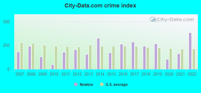
Crime rate in Newton detailed stats: murders, rapes, robberies, assaults, burglaries, thefts, arson
Full-time law enforcement employees in 2021, including police officers: 4 (4 officers - 3 male; 1 female).
| Officers per 1,000 residents here: | 2.77 |
| Alabama average: | 2.40 |
 Recent articles from our blog. Our writers, many of them Ph.D. graduates or candidates, create easy-to-read articles on a wide variety of topics.

 | UPDATED: New and Upcoming Projects. (3756 replies) |
| USFL and XFL officially merge to form UFL (21 replies) |
| Coming home....hopefully (84 replies) |
| A zoo and acquarium to be built here? (26 replies) |
| Are there a lot of ATL Falcons fans in B'ham? (20 replies) |
| SEC Network (59 replies) |
Latest news from Newton, AL collected exclusively by city-data.com from local newspapers, TV, and radio stations
Ancestries: American (39.0%), English (10.1%), Irish (3.7%), German (2.3%), Italian (2.1%), French (1.7%).
Current Local Time: CST time zone
Land area: 14.3 square miles.
Population density: 114 people per square mile (very low).
8 residents are foreign born
| This town: | 0.5% |
| Alabama: | 3.5% |
Median real estate property taxes paid for housing units with mortgages in 2022: $309 (0.3%)
Median real estate property taxes paid for housing units with no mortgage in 2022: $329 (0.4%)
Nearest city with pop. 50,000+: Dothan, AL  (13.6 miles , pop. 57,737).
Nearest city with pop. 200,000+: Montgomery, AL (81.1 miles , pop. 201,568).
Nearest city with pop. 1,000,000+: Houston, TX (593.1 miles , pop. 1,953,631).
Nearest cities:
), ), ), ), )Latitude: 31.34 N, Longitude: 85.59 W
Area code: 334
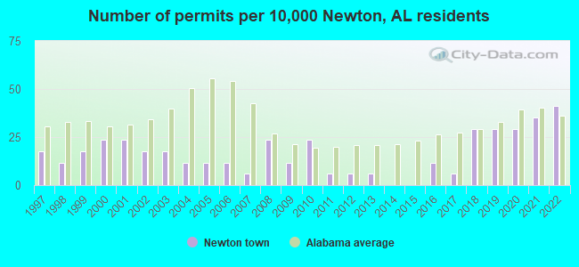
Single-family new house construction building permits:
- 2022: 7 buildings, average cost: $157,100
- 2021: 6 buildings, average cost: $157,100
- 2020: 5 buildings, average cost: $157,100
- 2019: 5 buildings, average cost: $157,100
- 2018: 5 buildings, average cost: $157,100
- 2017: 1 building, cost: $287,700
- 2016: 2 buildings, average cost: $243,200
- 2013: 1 building, cost: $133,900
- 2012: 1 building, cost: $195,000
- 2011: 1 building, cost: $80,000
- 2010: 4 buildings, average cost: $86,800
- 2009: 2 buildings, average cost: $92,500
- 2008: 4 buildings, average cost: $166,900
- 2007: 1 building, cost: $150,000
- 2006: 2 buildings, average cost: $50,000
- 2005: 2 buildings, average cost: $126,300
- 2004: 2 buildings, average cost: $126,300
- 2003: 3 buildings, average cost: $126,300
- 2002: 3 buildings, average cost: $126,300
- 2001: 4 buildings, average cost: $116,700
- 2000: 4 buildings, average cost: $116,700
- 1999: 3 buildings, average cost: $109,900
- 1998: 2 buildings, average cost: $102,100
- 1997: 3 buildings, average cost: $81,700
| Here: | 2.8% |
| Alabama: | 2.6% |
- Health care (10.0%)
- Construction (7.4%)
- Plastics & rubber products (7.0%)
- Educational services (5.6%)
- Public administration (4.8%)
- Other transportation, support activities, couriers (4.4%)
- Administrative & support & waste management services (4.4%)
- Construction (12.0%)
- Truck transportation (6.8%)
- Repair & maintenance (6.8%)
- Other transportation, support activities, couriers (6.3%)
- Plastics & rubber products (5.9%)
- Public administration (4.5%)
- Educational services (4.3%)
- Health care (18.0%)
- Plastics & rubber products (8.6%)
- Educational services (7.3%)
- Personal & laundry services (6.4%)
- Department & other general merchandise stores (6.1%)
- Administrative & support & waste management services (5.5%)
- Public administration (5.2%)
- Vehicle and mobile equipment mechanics, installers, and repairers (7.8%)
- Other production occupations, including supervisors (7.5%)
- Driver/sales workers and truck drivers (6.4%)
- Other sales and related occupations, including supervisors (4.2%)
- Material recording, scheduling, dispatching, and distributing workers (4.2%)
- Laborers and material movers, hand (3.5%)
- Electrical equipment mechanics and other installation, maintenance, and repair workers, including supervisors (3.5%)
- Vehicle and mobile equipment mechanics, installers, and repairers (13.5%)
- Driver/sales workers and truck drivers (10.8%)
- Other production occupations, including supervisors (6.3%)
- Electrical equipment mechanics and other installation, maintenance, and repair workers, including supervisors (6.1%)
- Laborers and material movers, hand (5.4%)
- Material recording, scheduling, dispatching, and distributing workers (5.0%)
- Building and grounds cleaning and maintenance occupations (4.1%)
- Other production occupations, including supervisors (9.2%)
- Supervisors and other personal care and service workers, except child care workers (5.8%)
- Secretaries and administrative assistants (5.5%)
- Other office and administrative support workers, including supervisors (4.9%)
- Retail sales workers, except cashiers (4.9%)
- Other sales and related occupations, including supervisors (4.6%)
- Personal appearance workers (4.6%)
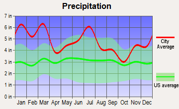
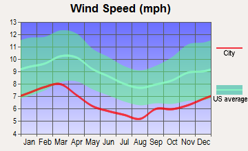
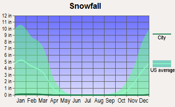
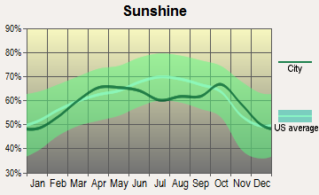
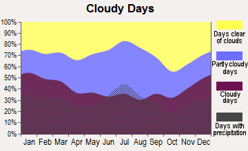
Average climate in Newton, Alabama
Based on data reported by over 4,000 weather stations

(lower is better)
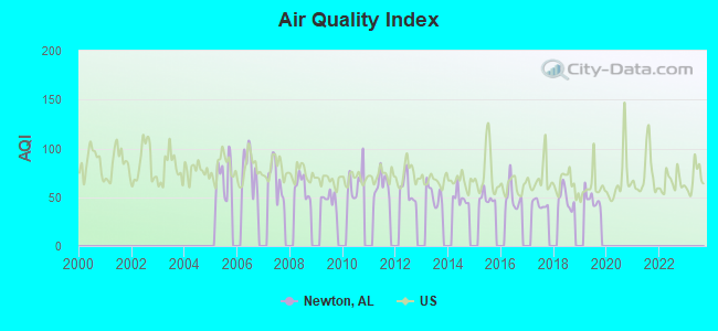
Air Quality Index (AQI) level in 2019 was 47.9. This is significantly better than average.
| City: | 47.9 |
| U.S.: | 72.6 |
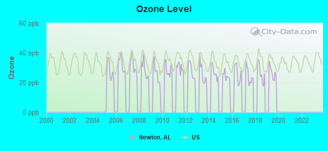
Ozone [ppb] level in 2019 was 26.7. This is better than average. Closest monitor was 14.7 miles away from the city center.
| City: | 26.7 |
| U.S.: | 33.3 |
Tornado activity:
Newton-area historical tornado activity is slightly below Alabama state average. It is 52% greater than the overall U.S. average.
On 3/1/2007, a category F4 (max. wind speeds 207-260 mph) tornado 19.8 miles away from the Newton town center killed 9 people and injured 50 people and caused $250 million in damages.
On 12/29/1973, a category F3 (max. wind speeds 158-206 mph) tornado 6.4 miles away from the town center injured 11 people and caused between $500,000 and $5,000,000 in damages.
Earthquake activity:
Newton-area historical earthquake activity is significantly above Alabama state average. It is 14% greater than the overall U.S. average.On 10/24/1997 at 08:35:17, a magnitude 4.9 (4.8 MB, 4.2 MS, 4.9 LG, Depth: 6.2 mi, Class: Light, Intensity: IV - V) earthquake occurred 100.5 miles away from Newton center
On 1/18/1999 at 07:00:53, a magnitude 4.8 (4.8 MB, 4.0 LG, Depth: 0.6 mi) earthquake occurred 172.5 miles away from the city center
On 4/29/2003 at 08:59:39, a magnitude 4.9 (4.4 MB, 4.6 MW, 4.9 LG) earthquake occurred 217.9 miles away from Newton center
On 8/2/1974 at 08:52:09, a magnitude 4.9 (4.3 MB, 4.9 LG) earthquake occurred 251.5 miles away from the city center
On 4/29/2003 at 08:59:39, a magnitude 4.6 (4.6 MW, Depth: 12.3 mi) earthquake occurred 217.8 miles away from Newton center
On 11/7/2004 at 11:20:21, a magnitude 4.3 (4.3 MW, Depth: 3.1 mi) earthquake occurred 164.3 miles away from the city center
Magnitude types: regional Lg-wave magnitude (LG), body-wave magnitude (MB), surface-wave magnitude (MS), moment magnitude (MW)
Natural disasters:
The number of natural disasters in Dale County (24) is greater than the US average (15).Major Disasters (Presidential) Declared: 17
Emergencies Declared: 5
Causes of natural disasters: Storms: 14, Tornadoes: 10, Floods: 9, Hurricanes: 6, Winds: 4, Drought: 1, Snowfall: 1, Tropical Storm: 1, Winter Storm: 1, Other: 1 (Note: some incidents may be assigned to more than one category).

Hospitals and medical centers near Newton:
- DOTHAN DIALYSIS (Dialysis Facility, about 6 miles away; DOTHAN, AL)
- OAKVIEW MANOR HEALTH CARE CENTER (Nursing Home, about 7 miles away; OZARK, AL)
- OZARK DIALYSIS (Dialysis Facility, about 8 miles away; OZARK, AL)
- COMMUNITY HOSPICE OF DALE MEDICAL CENTER (Hospital, about 8 miles away; OZARK, AL)
- DALE MEDICAL CTR HOME HEALTH (Home Health Center, about 8 miles away; OZARK, AL)
- DALE MEDICAL CENTER Acute Care Hospitals (about 8 miles away; OZARK, AL)
- WIREGRASS HOSPICE OZARK (Hospital, about 9 miles away; OZARK, AL)
Heliports located in Newton:
Operable nuclear power plants near Newton:
- 14 miles: Joseph M. Farley 1 and 2 in Dothan, AL.
Colleges/universities with over 2000 students nearest to Newton:
- George C Wallace State Community College-Dothan (about 8 miles; Dothan, AL; Full-time enrollment: 3,611)
- Enterprise State Community College (about 15 miles; Enterprise, AL; FT enrollment: 2,101)
- Troy University (about 38 miles; Troy, AL; FT enrollment: 16,148)
- Bainbridge State College (about 70 miles; Bainbridge, GA; FT enrollment: 2,308)
- Tuskegee University (about 76 miles; Tuskegee, AL; FT enrollment: 2,810)
- Northwest Florida State College (about 77 miles; Niceville, FL; FT enrollment: 5,052)
- Auburn University at Montgomery (about 79 miles; Montgomery, AL; FT enrollment: 4,092)
Public high school in Newton:
- WICKSBURG HIGH SCH (Students: 925, Location: 1172 S STATE HIGHWAY 123, Grades: KG-12)
Public elementary/middle school in Newton:
- NEWTON ELEM SCH (Students: 250, Location: 523 SOUTH COLLEGE ST, Grades: KG-6)
Points of interest:
Notable location: Newton Fire Department (A). Display/hide its location on the map
Churches in Newton include: Union Church (A), First Assembly of God Church (B), Newton Baptist Church (C), Newton United Methodist Church (D), Antioch Baptist Church (E), No Greater Love Holiness Church (F). Display/hide their locations on the map
Cemeteries: Woodham Cemetery (1), Newton City Cemetery (2). Display/hide their locations on the map
Reservoir: James Crooks Lake (A). Display/hide its location on the map
Creeks: Killebrew Factory Creek (A), Hurricane Creek (B). Display/hide their locations on the map
Drinking water stations with addresses in Newton that have no violations reported:
- NEWTON WATER WORKS BOARD (Population served: 2,190, Primary Water Source Type: Groundwater)
| This town: | 2.3 people |
| Alabama: | 2.5 people |
| This town: | 67.5% |
| Whole state: | 67.8% |
| This town: | 4.3% |
| Whole state: | 4.7% |
Likely homosexual households (counted as self-reported same-sex unmarried-partner households)
- Lesbian couples: 0.2% of all households
- Gay men: 0.2% of all households
Banks with branches in Newton (2011 data):
- City Bank of Hartford: Newton Office Branch at 465 S. College St, branch established on 2007/06/15. Info updated 2006/11/03: Bank assets: $57.1 mil, Deposits: $51.3 mil, headquarters in Hartford, AL, positive income, Agricultural Specialization, 2 total offices, Holding Company: Hartford Financial Corporation
For population 15 years and over in Newton:
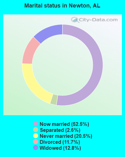
- Never married: 20.5%
- Now married: 52.5%
- Separated: 2.6%
- Widowed: 12.8%
- Divorced: 11.7%
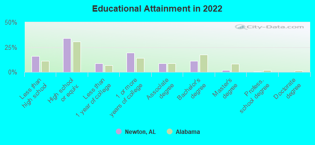
For population 25 years and over in Newton:
- High school or higher: 82.3%
- Bachelor's degree or higher: 12.6%
- Graduate or professional degree: 2.3%
- Unemployed: 5.3%
- Mean travel time to work (commute): 41.2 minutes
| Here: | 10.4 |
| Alabama average: | 11.5 |
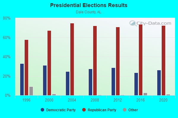
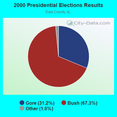
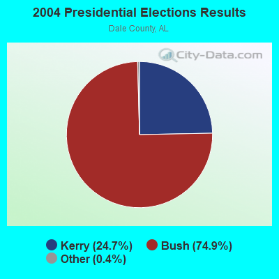


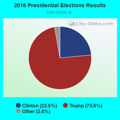
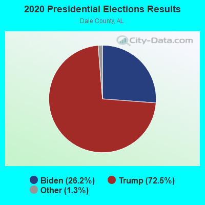
Graphs represent county-level data. Detailed 2008 Election Results
Religion statistics for Newton, AL (based on Dale County data)
| Religion | Adherents | Congregations |
|---|---|---|
| Evangelical Protestant | 17,979 | 68 |
| Mainline Protestant | 3,712 | 27 |
| Black Protestant | 1,891 | 9 |
| Other | 872 | 4 |
| Catholic | 278 | 1 |
| None | 25,519 | - |
Food Environment Statistics:
| Dale County: | 1.66 / 10,000 pop. |
| Alabama: | 1.89 / 10,000 pop. |
| Here: | 0.21 / 10,000 pop. |
| Alabama: | 0.20 / 10,000 pop. |
| Here: | 0.62 / 10,000 pop. |
| State: | 0.65 / 10,000 pop. |
| Dale County: | 6.65 / 10,000 pop. |
| State: | 6.32 / 10,000 pop. |
| This county: | 4.98 / 10,000 pop. |
| Alabama: | 5.75 / 10,000 pop. |
| This county: | 12.5% |
| Alabama: | 11.8% |
| Dale County: | 33.1% |
| Alabama: | 31.7% |
| Here: | 11.1% |
| Alabama: | 13.5% |
Health and Nutrition:
| This city: | 46.3% |
| Alabama: | 49.0% |
| Newton: | 42.8% |
| Alabama: | 45.7% |
| This city: | 30.3 |
| State: | 28.9 |
| Here: | 18.9% |
| State: | 20.7% |
| Here: | 13.1% |
| Alabama: | 11.0% |
| This city: | 6.4 |
| Alabama: | 6.8 |
| Here: | 36.1% |
| Alabama: | 34.4% |
| Newton: | 51.5% |
| State: | 55.2% |
| Newton: | 83.3% |
| Alabama: | 79.3% |
More about Health and Nutrition of Newton, AL Residents
| Local government employment and payroll (March 2022) | |||||
| Function | Full-time employees | Monthly full-time payroll | Average yearly full-time wage | Part-time employees | Monthly part-time payroll |
|---|---|---|---|---|---|
| Police Protection - Officers | 5 | $20,560 | $49,344 | 0 | $0 |
| Streets and Highways | 2 | $5,870 | $35,220 | 0 | $0 |
| Welfare | 1 | $2,480 | $29,760 | 2 | $2,167 |
| Police - Other | 1 | $2,480 | $29,760 | 1 | $531 |
| Judicial and Legal | 1 | $2,847 | $34,164 | 0 | $0 |
| Local Libraries | 0 | $0 | 1 | $1,078 | |
| Other Government Administration | 0 | $0 | 6 | $331 | |
| Totals for Government | 10 | $34,236 | $41,083 | 10 | $4,107 |
Newton government finances - Expenditure in 2017 (per resident):
- Current Operations - Central Staff Services: $196,000 ($120.69)
Regular Highways: $170,000 ($104.68)
Police Protection: $140,000 ($86.21)
Solid Waste Management: $100,000 ($61.58)
Public Welfare - Other: $41,000 ($25.25)
Libraries: $16,000 ($9.85)
Judicial and Legal Services: $16,000 ($9.85)
Miscellaneous Commercial Activities - Other: $6,000 ($3.69)
Parks and Recreation: $3,000 ($1.85)
- Intergovernmental to Local - Other - Police Protection: $10,000 ($6.16)
Other - Correctional Institutions: $2,000 ($1.23)
- Intergovernmental to State - Judicial and Legal Services: $35,000 ($21.55)
- Total Salaries and Wages: $239,000 ($147.17)
Newton government finances - Revenue in 2017 (per resident):
- Charges - Solid Waste Management: $126,000 ($77.59)
Miscellaneous Commercial Activities: $4,000 ($2.46)
Housing and Community Development: $1,000 ($0.62)
- Local Intergovernmental - General Local Government Support: $2,000 ($1.23)
- Miscellaneous - Fines and Forfeits: $79,000 ($48.65)
General Revenue - Other: $5,000 ($3.08)
Donations From Private Sources: $3,000 ($1.85)
- State Intergovernmental - Other: $16,000 ($9.85)
General Local Government Support: $9,000 ($5.54)
- Tax - General Sales and Gross Receipts: $195,000 ($120.07)
Public Utilities Sales: $84,000 ($51.72)
Motor Fuels Sales: $54,000 ($33.25)
Occupation and Business License - Other: $53,000 ($32.64)
Property: $45,000 ($27.71)
Alcoholic Beverage Sales: $16,000 ($9.85)
Motor Vehicle License: $12,000 ($7.39)
Tobacco Products Sales: $10,000 ($6.16)
Other: $1,000 ($0.62)
Newton government finances - Debt in 2017 (per resident):
- Short Term Debt Outstanding - Beginning: $27,000 ($16.63)
End of Fiscal Year: $9,000 ($5.54)
Newton government finances - Cash and Securities in 2017 (per resident):
- Other Funds - Cash and Securities: $31,000 ($19.09)
13.66% of this county's 2021 resident taxpayers lived in other counties in 2020 ($45,663 average adjusted gross income)
| Here: | 13.66% |
| Alabama average: | 6.87% |
0.30% of residents moved from foreign countries ($1,125 average AGI)
Dale County: 0.30% Alabama average: 0.02%
Top counties from which taxpayers relocated into this county between 2020 and 2021:
| from Houston County, AL | |
| from Coffee County, AL | |
| from Henry County, AL |
12.52% of this county's 2020 resident taxpayers moved to other counties in 2021 ($49,280 average adjusted gross income)
| Here: | 12.52% |
| Alabama average: | 6.41% |
0.33% of residents moved to foreign countries ($1,788 average AGI)
Dale County: 0.33% Alabama average: 0.02%
Top counties to which taxpayers relocated from this county between 2020 and 2021:
| to Houston County, AL | |
| to Coffee County, AL | |
| to Henry County, AL |
Strongest AM radio stations in Newton:
- WQLS (1200 AM; 10 kW; OZARK, AL; Owner: STYLES BROADCASTING OF DOTHAN, INC.)
- WOOF (560 AM; 5 kW; DOTHAN, AL; Owner: WOOF, INC.)
- WTKN (1560 AM; daytime; 5 kW; DALEVILLE, AL; Owner: JOSEPH A. ADAMS, SR.)
- WOZK (900 AM; 1 kW; OZARK, AL; Owner: OZARK B/CING. CORP.)
- WAGF (1320 AM; 2 kW; DOTHAN, AL)
- WSTT (730 AM; 25 kW; THOMASVILLE, GA; Owner: MARION R. WILLIAMS)
- WTBF (970 AM; 5 kW; TROY, AL; Owner: TROY BROADCASTING CORP.)
- WASG (550 AM; 25 kW; ATMORE, AL; Owner: 550 AM, INC)
- WWNT (1450 AM; 1 kW; DOTHAN, AL; Owner: DOVE BROADCASTING, INC.)
- WJOX (690 AM; 50 kW; BIRMINGHAM, AL; Owner: CITADEL BROADCASTING COMPANY)
- WZEP (1460 AM; 10 kW; DEFUNIAK SPRINGS, FL; Owner: WALTON COUNTY BROADCASTING, INC.)
- WGST (640 AM; 50 kW; ATLANTA, GA; Owner: CITICASTERS LICENSES, L.P.)
- WMAC (940 AM; 50 kW; MACON, GA; Owner: CUMULUS LICENSING CORP.)
Strongest FM radio stations in Newton:
- WXUS (100.5 FM; FORT RUCKER, AL; Owner: SKYWAY BROADCASTING, LTD.)
- WDYF (90.3 FM; DOTHAN, AL; Owner: FAITH BROADCASTING, INC.)
- WAQG (91.7 FM; OZARK, AL; Owner: AMERICAN FAMILY ASSOCIATION)
- WJRL-FM (103.9 FM; OZARK, AL; Owner: STYLES BROADCASTING OF DOTHAN, INC.)
- WRWA (88.7 FM; DOTHAN, AL; Owner: TROY STATE UNIVERSITY)
- WOOF-FM (99.7 FM; DOTHAN, AL; Owner: WOOF, INC.)
- WTVY-FM (95.5 FM; DOTHAN, AL; Owner: STYLES BROADCASTING OF DOTHAN, INC.)
- WKMX (106.7 FM; ENTERPRISE, AL; Owner: WKMX, INC.)
- WDJR (96.9 FM; ENTERPRISE, AL; Owner: GULF SOUTH COMMUNICATIONS, INC.)
- WOAB (104.9 FM; OZARK, AL; Owner: OZARK BROADCASTING CORPORATION)
- WAGF-FM (101.3 FM; DOTHAN, AL; Owner: WILSON BROADCASTING CO., INC.)
- WZTZ (101.1 FM; ELBA, AL; Owner: ELBA RADIO COMPANY)
- WESP (102.5 FM; DOTHAN, AL; Owner: GULF SOUTH COMMUNICATIONS, INC)
- WRJM-FM (93.7 FM; GENEVA, AL; Owner: STAGE DOOR DEVELOPMENT, INC.)
- WIZB (94.3 FM; ABBEVILLE, AL; Owner: CELEBRATIONS COMMUNICATIONS COMPANY, INC.)
- WQLD (104.3 FM; LUVERNE, AL; Owner: CAPSTAR TX LIMITED PARTNERSHIP)
- WZHT (105.7 FM; TROY, AL; Owner: CAPSTAR TX LIMITED PARTNERSHIP)
- WVOB (91.3 FM; DOTHAN, AL; Owner: BETHANY BIBLE COLLEGE & B.T.S. INC.)
- WGTF (89.5 FM; DOTHAN, AL; Owner: DOTHAN COMMUNITY EDUCL. RADIO, INC.)
- WJJN (92.1 FM; COLUMBIA, AL; Owner: WILSON BROADCASTING CO., INC.)
TV broadcast stations around Newton:
- WDFX-TV (Channel 34; OZARK, AL; Owner: WAITT LICENSE CO. OF ALABAMA, L.L.C.)
- WTVY (Channel 4; DOTHAN, AL; Owner: GRAY MIDAMERICA TV LICENSEE CORP.)
- WDHN (Channel 18; DOTHAN, AL; Owner: MORRIS NETWORK OF ALABAMA, INC.)
- WJJN-LP (Channel 5; DOTHAN, AL; Owner: JAMES WILSON, III)
- W41BN (Channel 41; DOTHAN, AL; Owner: TRINITY BROADCASTING NETWORK)
- WGIQ (Channel 43; LOUISVILLE, AL; Owner: ALABAMA EDUCATIONAL TELEVISION COMMISSION)
- WRJM-TV (Channel 67; TROY, AL; Owner: JOSIE PARK BROADCASTING, INC.)
- WSFA (Channel 12; MONTGOMERY, AL; Owner: LIBCO, INC.)
- WCOV-TV (Channel 20; MONTGOMERY, AL; Owner: WOODS COMMUNICATIONS CORPORATION)
- Newton, Alabama
- Fatal accident count16
- Vehicles involved in fatal accidents19
- Fatal accidents involving drunk persons:7
- Fatalities16
- Persons involved in fatal accidents21
- Pedestrians involved in fatal accidents1
- Alabama average
- Fatal accident count10105
- Vehicles involved in fatal accidents15194
- Fatal accidents involving drunk persons3078
- Fatalities11206
- Persons involved in fatal accidents24496
- Pedestrians involved in fatal accidents1118
- National Bridge Inventory (NBI) Statistics
- 28Number of bridges
- 571ft / 174mTotal length
- $51,698,000Total costs
- 69,787Total average daily traffic
- 8,554Total average daily truck traffic
- 94,998Total future (year 2033) average daily traffic
- New bridges - historical statistics
- 21920-1929
- 11930-1939
- 101950-1959
- 11960-1969
- 21970-1979
- 71980-1989
- 41990-1999
- 12000-2009
FCC Registered Cell Phone Towers:
1 (See the full list of FCC Registered Cell Phone Towers in Newton)FCC Registered Antenna Towers:
75 (See the full list of FCC Registered Antenna Towers)FCC Registered Broadcast Land Mobile Towers:
1- Lat: 31.375639 Lon: -85.590889, Call Sign: WRDG931,
Assigned Frequencies: 151.685 MHz, 151.955 MHz, 151.977 MHz, 154.505 MHz, 154.515 MHz, 151.685 MHz, 151.955 MHz, 151.977 MHz, 154.505 MHz, 154.515 MHz, Grant Date: 04/26/2019, Expiration Date: 04/26/2029, Certifier: Kyle V Douglas, Registrant: Mobile Communications America, 232 Ross Clark Circle, Dothan, AL 36303, Phone: (334) 794-3777, Email:
FCC Registered Microwave Towers:
7- Electrical Substation 2 Mi S (Lat: 31.305444 Lon: -85.594083), Overall height: 88.4 m, Call Sign: WPND215,
Assigned Frequencies: 928.806 MHz, 952.806 MHz, Grant Date: 01/29/2002, Expiration Date: 04/01/2012, Cancellation Date: 06/02/2012, Registrant: Powersouth Energy Cooperative, 2027 East Three Notch St., Andalusia, AL 36420, Phone: (334) 427-3000, Fax: (334) 427-3439, Email:
- Wicksburg, 13490 Hwy. 84 West (Lat: 31.243917 Lon: -85.611611), Type: Ltower, Structure height: 76.2 m, Overall height: 80.8 m, Call Sign: WQYU525,
Assigned Frequencies: 5974.85 MHz, 6034.15 MHz, Grant Date: 01/24/2017, Expiration Date: 01/24/2027, Certifier: Gregory M Romano, Registrant: Verizon, 5055 Northpointe Pkwy, Alpharetta, GA 30022, Phone: (770) 797-1070, Email:
- NEWTON RELAY, Off Of County Road 9 (Lat: 31.300639 Lon: -85.584528), Type: Gtower, Structure height: 194.5 m, Call Sign: WRCL536, Licensee ID: L00088918,
Assigned Frequencies: 946.500 MHz, Grant Date: 10/31/2018, Expiration Date: 04/01/2028, Certifier: Clay Holladay, Registrant: Gulf South Communications, Inc., 3245 Montgomery Highwy Suite 1, Dothan, AL 36303, Phone: (334) 712-9233
- Newton Tower, Off Of County Road 9 (Lat: 31.300639 Lon: -85.584528), Type: Gtower, Structure height: 194.5 m, Call Sign: WRYJ568,
Assigned Frequencies: 941.925 MHz, 941.925 MHz, 941.925 MHz, 941.925 MHz, Grant Date: 08/17/2023, Expiration Date: 08/17/2033, Certifier: James R Buie, Registrant: Seminole Communications Inc., 825 South Foster St., Dothan, AL 36301, Phone: (334) 792-5054, Email:
- 9BH7433A, Oates Drive, 1/4 Mi East Of Hwy 123 (Newton) (Lat: 31.330028 Lon: -85.593333), Type: Ltower, Structure height: 77.1 m, Overall height: 80.2 m, Call Sign: WRYM869,
Assigned Frequencies: 19325.0 MHz, 19375.0 MHz, 19325.0 MHz, 19375.0 MHz, 19325.0 MHz, 19375.0 MHz, 19325.0 MHz, 19375.0 MHz, 19325.0 MHz, 19375.0 MHz... (+10 more), Grant Date: 08/29/2023, Expiration Date: 08/29/2033, Certifier: Jenny Knopf, Registrant: T-Mobile Usa, Inc., 12920 Se 38th Street, Bellevue, WA 98006, Phone: (425) 383-8401, Fax: (425) 383-4040, Email:
- 9C00313A, 13490 Hwy. 84 West (Lat: 31.243917 Lon: -85.611611), Type: Ltower, Structure height: 76.2 m, Overall height: 80.8 m, Call Sign: WRZG879,
Assigned Frequencies: 10915.0 MHz, 10915.0 MHz, 10915.0 MHz, 10915.0 MHz, 10915.0 MHz, 10915.0 MHz, 10915.0 MHz, 10915.0 MHz, 10915.0 MHz, 10915.0 MHz, 10915.0 MHz, Grant Date: 10/31/2023, Expiration Date: 10/31/2033, Certifier: Jenny Knopf, Registrant: T-Mobile Usa, Inc., 12920 Se 38th Street, Bellevue, WA 98006, Phone: (425) 383-8401, Fax: (425) 383-4040, Email:
- NEWTON, Oates Drive, 1/4 Mi East Of Hwy 123 (Newton) (Lat: 31.330028 Lon: -85.593333), Type: Gtower, Structure height: 77.1 m, Overall height: 80.2 m, Call Sign: WLN685,
Assigned Frequencies: 6286.19 MHz, 6315.84 MHz, Grant Date: 04/05/2011, Expiration Date: 02/01/2021, Cancellation Date: 10/14/2016, Certifier: Michael P Goggin, Registrant: At&t Mobility LLC, 1120 20th Street, Nw - Suite 1000, Washington, DC 20036, Phone: (202) 457-2055, Fax: (202) 457-3073, Email:
FCC Registered Amateur Radio Licenses:
23 (See the full list of FCC Registered Amateur Radio Licenses in Newton)FAA Registered Aircraft:
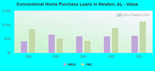
15 (See the full list of FAA Registered Aircraft in Newton)| Home Mortgage Disclosure Act Aggregated Statistics For Year 2003 (Based on 1 partial tract) | ||||||||||
| A) FHA, FSA/RHS & VA Home Purchase Loans | B) Conventional Home Purchase Loans | C) Refinancings | D) Home Improvement Loans | F) Non-occupant Loans on < 5 Family Dwellings (A B C & D) | ||||||
|---|---|---|---|---|---|---|---|---|---|---|
| Number | Average Value | Number | Average Value | Number | Average Value | Number | Average Value | Number | Average Value | |
| LOANS ORIGINATED | 3 | $77,323 | 6 | $61,468 | 16 | $93,372 | 2 | $12,105 | 2 | $25,070 |
| APPLICATIONS APPROVED, NOT ACCEPTED | 0 | $0 | 0 | $0 | 3 | $77,893 | 0 | $0 | 0 | $0 |
| APPLICATIONS DENIED | 0 | $0 | 2 | $33,740 | 11 | $94,138 | 1 | $13,390 | 0 | $0 |
| APPLICATIONS WITHDRAWN | 1 | $20,430 | 1 | $44,470 | 3 | $81,730 | 0 | $0 | 0 | $0 |
| FILES CLOSED FOR INCOMPLETENESS | 0 | $0 | 0 | $0 | 1 | $118,300 | 0 | $0 | 0 | $0 |
Detailed HMDA statistics for the following Tracts: 0213.00
| Private Mortgage Insurance Companies Aggregated Statistics For Year 2003 (Based on 1 partial tract) | ||||
| A) Conventional Home Purchase Loans | B) Refinancings | |||
|---|---|---|---|---|
| Number | Average Value | Number | Average Value | |
| LOANS ORIGINATED | 1 | $112,810 | 2 | $117,270 |
| APPLICATIONS APPROVED, NOT ACCEPTED | 0 | $0 | 0 | $0 |
| APPLICATIONS DENIED | 0 | $0 | 0 | $0 |
| APPLICATIONS WITHDRAWN | 0 | $0 | 0 | $0 |
| FILES CLOSED FOR INCOMPLETENESS | 0 | $0 | 0 | $0 |
Detailed PMIC statistics for the following Tracts: 0213.00
2004 - 2018 National Fire Incident Reporting System (NFIRS) incidents
- Fire incident types reported to NFIRS in Newton, AL
- 10949.8%Outside Fires
- 7333.3%Structure Fires
- 3315.1%Mobile Property/Vehicle Fires
- 41.8%Other
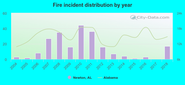 Based on the data from the years 2004 - 2018 the average number of fire incidents per year is 15. The highest number of fires - 44 took place in 2010, and the least - 0 in 2017. The data has an increasing trend.
 When looking into fire subcategories, the most reports belonged to: Outside Fires (49.8%), and Structure Fires (33.3%).
| Most common first names in Newton, AL among deceased individuals | ||
| Name | Count | Lived (average) |
|---|---|---|
| James | 36 | 76.7 years |
| John | 32 | 71.7 years |
| William | 27 | 73.9 years |
| Mary | 26 | 72.6 years |
| Robert | 23 | 68.4 years |
| Annie | 16 | 78.1 years |
| Willie | 14 | 76.1 years |
| Billy | 11 | 68.4 years |
| George | 9 | 77.8 years |
| Charles | 9 | 69.1 years |
| Most common last names in Newton, AL among deceased individuals | ||
| Last name | Count | Lived (average) |
|---|---|---|
| Thomley | 33 | 80.0 years |
| Smith | 21 | 72.3 years |
| Jones | 19 | 77.4 years |
| Watson | 14 | 68.6 years |
| Johnson | 13 | 71.0 years |
| Sanders | 12 | 79.8 years |
| Turner | 11 | 75.4 years |
| Gilley | 10 | 68.8 years |
| Williams | 10 | 83.5 years |
| Glover | 10 | 76.0 years |
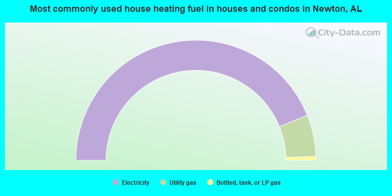
- 87.8%Electricity
- 11.2%Utility gas
- 1.0%Bottled, tank, or LP gas
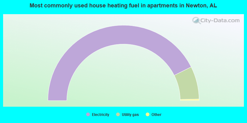
- 85.8%Electricity
- 14.2%Utility gas
Newton compared to Alabama state average:
- Median house value below state average.
- Unemployed percentage below state average.
- Black race population percentage below state average.
- Hispanic race population percentage significantly below state average.
- Foreign-born population percentage significantly below state average.
- Length of stay since moving in above state average.
- Percentage of population with a bachelor's degree or higher below state average.

|
Total of 5 patent applications in 2008-2024.