Ochoco, Oregon
Ochoco: Big Summit Prairie...Now with cattle & Barbed wire, a 150yrs ago it was the center of the Shoshone nation, and covered in Tepees & Indian Ponies...
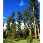
Ochoco: Ponderosa's....
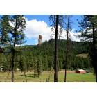
Ochoco: Steins Pillar up Mill Creek.....

Ochoco: At an Ochoco Trailhead.....
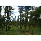
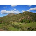
Ochoco: In the Ochocos.....
Ochoco: The Dry side of the Ochocos.....
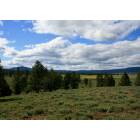
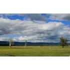
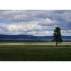
Ochoco: Big Summit Prairie.....
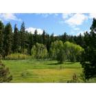
Ochoco: Aspens.....
Ochoco: Source of the Crooked River.....
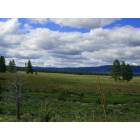
Ochoco: Where are the Tepees??...Storm clouds over Big Summit Prairie...
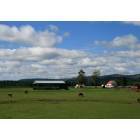
Ochoco: Idyllic Ranch.....
- see
15
more - add
your
Submit your own pictures of this place and show them to the world
- OSM Map
- General Map
- Google Map
- MSN Map

| Males: 8,158 | |
| Females: 8,350 |
| Median resident age: | 36.5 years |
| Oregon median age: | 36.3 years |
Zip code: 97754
| Ochoco: | $71,960 |
| OR: | $75,657 |
Estimated per capita income in 2022: $38,163 (it was $16,494 in 2000)
Ochoco CCD income, earnings, and wages data
Estimated median house or condo value in 2022: $394,772 (it was $95,000 in 2000)
| Ochoco: | $394,772 |
| OR: | $475,600 |
Detailed information about poverty and poor residents in Ochoco, OR


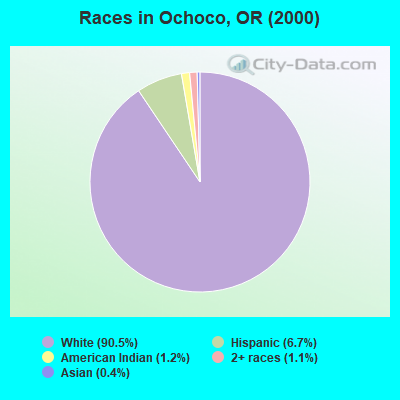
- 12,68090.5%White alone
- 9356.7%Hispanic
- 1651.2%American Indian alone
- 1491.1%Two or more races
- 630.4%Asian alone
- 90.06%Other race alone
- 50.04%Black alone
- 60.04%Native Hawaiian and Other
Pacific Islander alone
Races in Ochoco detailed stats: ancestries, foreign born residents, place of birth
 Recent articles from our blog. Our writers, many of them Ph.D. graduates or candidates, create easy-to-read articles on a wide variety of topics.
Current Local Time: PST time zone
Land area: 698.6 square miles.
Population density: 24 people per square mile (very low).

| Ochoco CCD: | 1.3% ($1,223) |
| Oregon: | 1.2% ($1,687) |
Nearest city with pop. 50,000+: Bend, OR  (36.3 miles , pop. 52,029).
Nearest city with pop. 200,000+: Northwest Clackamas, OR (118.4 miles , pop. 224,220).
Nearest city with pop. 1,000,000+: Los Angeles, CA (720.9 miles , pop. 3,694,820).
Nearest cities:
), ), ), )Latitude: 44.35 N, Longitude: 120.70 W
Area code commonly used in this area: 541

| Here: | 6.2% |
| Oregon: | 3.9% |
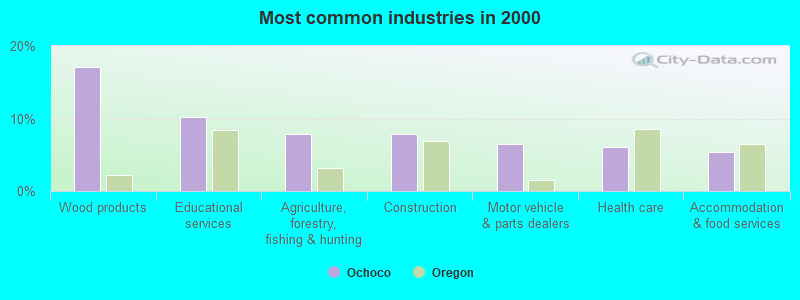
- Wood products (17.1%)
- Educational services (10.2%)
- Agriculture, forestry, fishing & hunting (7.9%)
- Construction (7.8%)
- Motor vehicle & parts dealers (6.4%)
- Health care (6.0%)
- Accommodation & food services (5.4%)
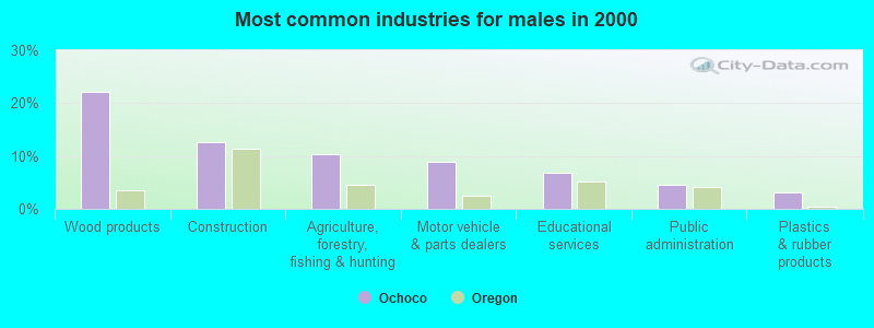
- Wood products (22.0%)
- Construction (12.7%)
- Agriculture, forestry, fishing & hunting (10.3%)
- Motor vehicle & parts dealers (9.0%)
- Educational services (6.7%)
- Public administration (4.6%)
- Plastics & rubber products (3.1%)
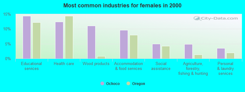
- Educational services (14.3%)
- Health care (12.4%)
- Wood products (11.1%)
- Accommodation & food services (9.6%)
- Social assistance (4.9%)
- Agriculture, forestry, fishing & hunting (4.8%)
- Personal & laundry services (3.5%)
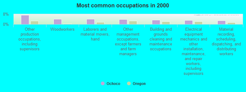
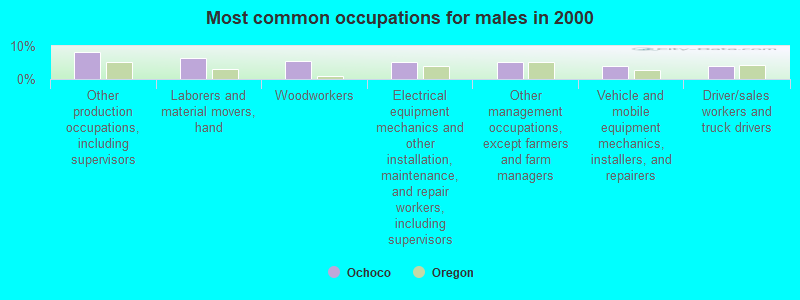
- Other production occupations, including supervisors (7.2%)
- Woodworkers (4.0%)
- Laborers and material movers, hand (4.0%)
- Other management occupations, except farmers and farm managers (3.9%)
- Building and grounds cleaning and maintenance occupations (3.4%)
- Electrical equipment mechanics and other installation, maintenance, and repair workers, including supervisors (3.1%)
- Material recording, scheduling, dispatching, and distributing workers (3.0%)
- Other production occupations, including supervisors (8.3%)
- Laborers and material movers, hand (6.3%)
- Woodworkers (5.5%)
- Electrical equipment mechanics and other installation, maintenance, and repair workers, including supervisors (5.2%)
- Other management occupations, except farmers and farm managers (5.1%)
- Vehicle and mobile equipment mechanics, installers, and repairers (4.0%)
- Driver/sales workers and truck drivers (3.9%)
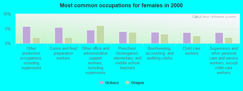
- Other production occupations, including supervisors (5.8%)
- Cooks and food preparation workers (5.5%)
- Other office and administrative support workers, including supervisors (4.6%)
- Preschool, kindergarten, elementary, and middle school teachers (4.0%)
- Bookkeeping, accounting, and auditing clerks (3.8%)
- Child care workers (3.7%)
- Supervisors and other personal care and service workers, except child care workers (3.7%)
Average climate in Ochoco, Oregon
Based on data reported by over 4,000 weather stations


(lower is better)
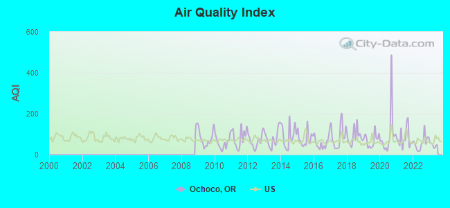
Air Quality Index (AQI) level in 2022 was 57.8. This is better than average.
| City: | 57.8 |
| U.S.: | 72.6 |
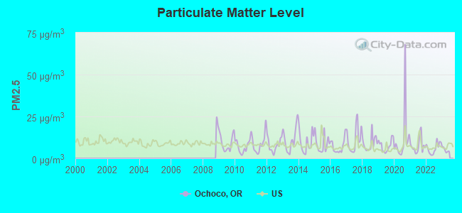
Particulate Matter (PM2.5) [µg/m3] level in 2022 was 6.05. This is better than average. Closest monitor was 7.9 miles away from the city center.
| City: | 6.05 |
| U.S.: | 8.11 |
Earthquake activity:
Ochoco-area historical earthquake activity is significantly above Oregon state average. It is 2404% greater than the overall U.S. average.On 10/3/1915 at 06:52:48, a magnitude 7.6 (7.6 UK, Class: Major, Intensity: VIII - XII) earthquake occurred 312.6 miles away from the city center
On 4/13/1949 at 19:55:42, a magnitude 7.0 (7.0 UK) earthquake occurred 218.3 miles away from Ochoco center, causing $80,000,000 total damage
On 1/31/1922 at 13:17:28, a magnitude 7.6 (7.6 UK) earthquake occurred 353.3 miles away from Ochoco center
On 11/8/1980 at 10:27:34, a magnitude 7.2 (6.2 MB, 7.2 MS, 7.2 MW, 7.0 ML) earthquake occurred 289.2 miles away from Ochoco center
On 2/28/2001 at 18:54:32, a magnitude 6.8 (6.5 MB, 6.6 MS, 6.8 MW, Class: Strong, Intensity: VII - IX) earthquake occurred 209.8 miles away from Ochoco center, causing $2,000,000,000 total damage and $305,000,000 insured losses
On 2/28/2001 at 18:54:32, a magnitude 6.8 (6.8 MD, Depth: 32.2 mi) earthquake occurred 216.6 miles away from the city center
Magnitude types: body-wave magnitude (MB), duration magnitude (MD), local magnitude (ML), surface-wave magnitude (MS), moment magnitude (MW)
Natural disasters:
The number of natural disasters in Crook County (8) is smaller than the US average (15).Major Disasters (Presidential) Declared: 6
Emergencies Declared: 2
Causes of natural disasters: Floods: 4, Landslides: 2, Mudslides: 2, Winter Storms: 2, Drought: 1, Heavy Rain: 1, Hurricane: 1, Storm: 1, Other: 1 (Note: some incidents may be assigned to more than one category).
Colleges/universities with over 2000 students nearest to Ochoco:
- Central Oregon Community College (about 38 miles; Bend, OR; Full-time enrollment: 5,217)
- Clackamas Community College (about 114 miles; Oregon City, OR; FT enrollment: 4,261)
- Mt Hood Community College (about 116 miles; Gresham, OR; FT enrollment: 11,847)
- Lane Community College (about 118 miles; Eugene, OR; FT enrollment: 6,373)
- University of Oregon (about 120 miles; Eugene, OR; FT enrollment: 23,329)
- Chemeketa Community College (about 120 miles; Salem, OR; FT enrollment: 10,746)
- Linn-Benton Community College (about 121 miles; Albany, OR; FT enrollment: 4,511)
Points of interest:
Notable locations in Ochoco: Keystone Ranch (A), Barney (B), Scissorsville (C), Howard (D), Windy Acres Dairy Farm (E), Trail Cabin (F), Joe Fisher Ranch (G), Bandit Spring Safety Rest Area (H), Walton Lake Recreation Site (I), Negus Ranch (J), Elliot Ranch (K), Lakin Place (L), Cow Camp Cabin (M), Whistler Recreation Site (N), Walton Lake Campground (O), Biggs Spring Recreation Site (P), Ochoco Recreation Site (Q), Cougar Forest Camp (R), McKay Creek Forest Camp (S), Cayuse Forest Camp (T). Display/hide their locations on the map
Cemeteries: Juniper Haven Cemetery (1), Mill Creek Cemetery (2), Howard Cemetery (3). Display/hide their locations on the map
Reservoirs: Lost Spring Reservoir (A), Johnson Creek Reservoir (B), Walton Lake (C), Marks Lake (D), Koch Reservoir (E), Crawford Reservoir (F), Peterson Creek Reservoir (G), Ochoco Reservoir (H). Display/hide their locations on the map
Streams, rivers, and creeks: Winter Creek (A), Wolf Creek (B), Kyle Creek (C), Kuiman Creek (D), Yellowjacket Creek (E), Juniper Creek (F), Burn Creek (G), Riley Creek (H), Jungle Creek (I). Display/hide their locations on the map
Parks in Ochoco include: Gary A Ward Park (1), Harwood Park (2), Kilowatt Park (3), Library Park (4), Mini Park (5), Mountain View Park (6), Rimrock Park (7), Stryker Park (8), Davidson Park (9). Display/hide their locations on the map
| This place: | 2.6 people |
| Oregon: | 2.5 people |
| This place: | 53.0% |
| Whole state: | 66.3% |
| This place: | 5.7% |
| Whole state: | 6.3% |
Likely homosexual households (counted as self-reported same-sex unmarried-partner households)
- Lesbian couples: 0.2% of all households
- Gay men: 0.2% of all households
| This place: | 11.3% |
| Whole state: | 11.6% |
| This place: | 6.2% |
| Whole state: | 5.0% |
People in group quarters in Ochoco in 2000:
- 75 people in residential treatment centers for emotionally disturbed children
- 52 people in other noninstitutional group quarters
- 49 people in unknown juvenile institutions
- 45 people in nursing homes
- 21 people in local jails and other confinement facilities (including police lockups)
- 13 people in other group homes
- 7 people in hospitals or wards for drug/alcohol abuse
- 6 people in homes or halfway houses for drug/alcohol abuse
- 4 people in other nonhousehold living situations
For population 15 years and over in Ochoco:
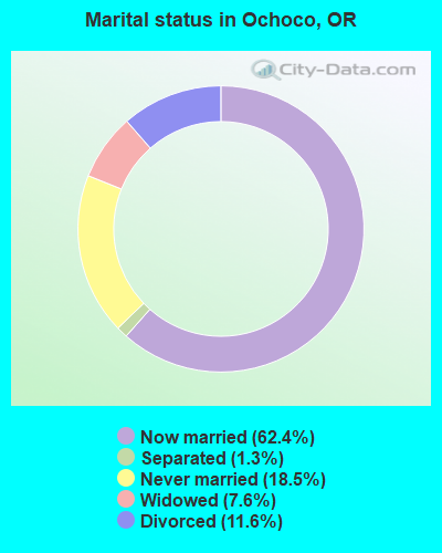
- Never married: 18.5%
- Now married: 62.4%
- Separated: 1.3%
- Widowed: 7.6%
- Divorced: 11.6%
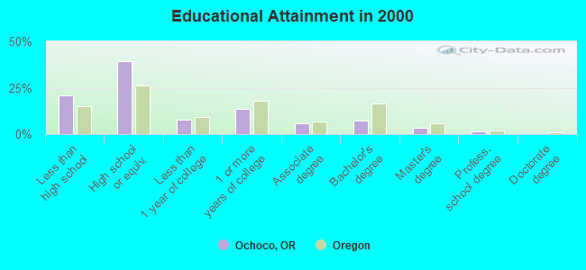
For population 25 years and over in Ochoco:
- High school or higher: 79.1%
- Bachelor's degree or higher: 12.4%
- Graduate or professional degree: 5.1%
- Unemployed: 6.9%
- Mean travel time to work (commute): 15.8 minutes
| Here: | 11.3 |
| Oregon average: | 11.5 |
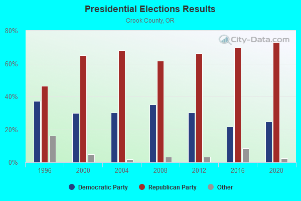
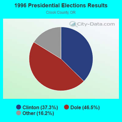
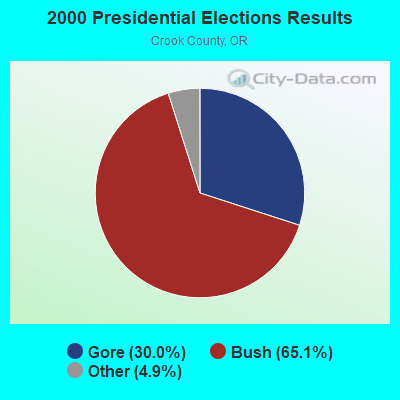
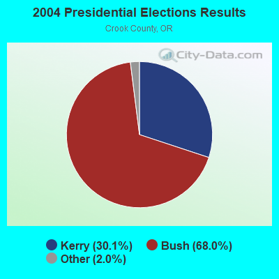
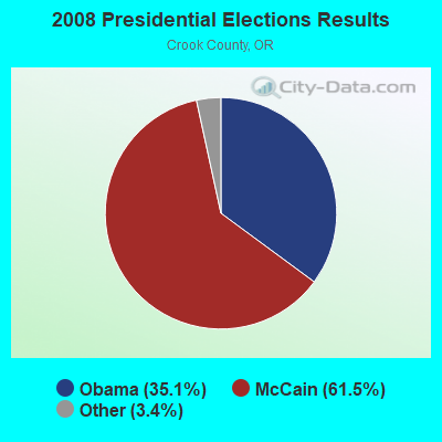

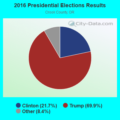
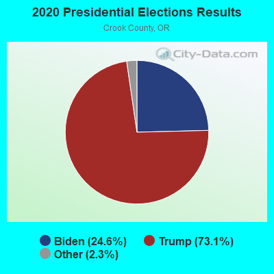
Graphs represent county-level data. Detailed 2008 Election Results
Religion statistics for Ochoco, OR (based on Crook County data)
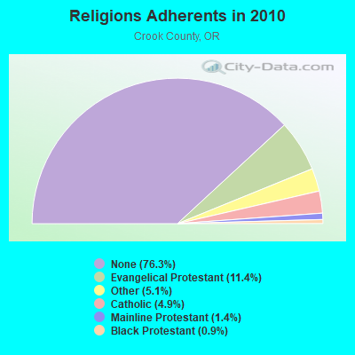
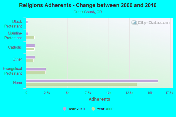
| Religion | Adherents | Congregations |
|---|---|---|
| Evangelical Protestant | 2,385 | 16 |
| Other | 1,079 | 3 |
| Catholic | 1,035 | 1 |
| Mainline Protestant | 285 | 3 |
| Black Protestant | 180 | 1 |
| None | 16,014 | - |
Food Environment Statistics:
| Crook County: | 2.63 / 10,000 pop. |
| Oregon: | 2.03 / 10,000 pop. |
| This county: | 0.44 / 10,000 pop. |
| Oregon: | 0.33 / 10,000 pop. |
| This county: | 1.31 / 10,000 pop. |
| Oregon: | 2.01 / 10,000 pop. |
| Here: | 3.50 / 10,000 pop. |
| Oregon: | 1.69 / 10,000 pop. |
| Crook County: | 7.88 / 10,000 pop. |
| State: | 9.93 / 10,000 pop. |
| Crook County: | 8.1% |
| Oregon: | 7.4% |
| This county: | 29.9% |
| State: | 25.6% |
| This county: | 12.1% |
| Oregon: | 14.2% |
Strongest AM radio stations in Ochoco:
- KRCO (690 AM; 1 kW; PRINEVILLE, OR; Owner: HORIZON BROADCASTING GROUP LLC)
- KBND (1110 AM; 12 kW; BEND, OR; Owner: COMBINED COMMUNICATIONS, INC.)
- KICE (940 AM; 10 kW; BEND, OR; Owner: GCC BEND, LLC)
- KPOJ (620 AM; 50 kW; PORTLAND, OR; Owner: CITICASTERS LICENSES, L.P.)
- KXL (750 AM; 50 kW; PORTLAND, OR; Owner: ROSE CITY RADIO CORPORATION)
- KPAM (860 AM; 50 kW; TROUTDALE, OR; Owner: PAMPLIN BROADCASTING-OREGON, INC.)
- KOTK (1080 AM; 50 kW; PORTLAND, OR; Owner: FISHER BROADCASTING - PORTLAND RADIO, L.L.C.)
- KPNW (1120 AM; 50 kW; EUGENE, OR; Owner: CAPSTAR TX LIMITED PARTNERSHIP)
- KEX (1190 AM; 50 kW; PORTLAND, OR; Owner: CITICASTERS LICENSES, L.P.)
- KKSN (1520 AM; 50 kW; OREGON CITY, OR; Owner: ENTERCOM PORTLAND LICENSE, LLC)
- KKAD (1550 AM; 50 kW; VANCOUVER, WA; Owner: PAMPLIN BROADCASTING-WASHINGTON, INC)
- KDUN (1030 AM; 50 kW; REEDSPORT, OR; Owner: PAMPLIN BROADCASTING-OREGON, INC.)
- KBOI (670 AM; 50 kW; BOISE, ID; Owner: CITADEL BROADCASTING COMPANY)
Strongest FM radio stations in Ochoco:
- KWRX (88.5 FM; REDMOND, OR; Owner: ST BD OF HIGHER ED FOR THE UN OF OR)
- KMJZ-FM (95.1 FM; PRINEVILLE, OR; Owner: HORIZON BROADCASTING GROUP LLC)
- KSJJ (102.9 FM; REDMOND, OR; Owner: GCC BEND, LLC)
- K266AI (101.1 FM; BEND, OR; Owner: CALVARY CHAPEL OF TWIN FALLS, INC.)
- KWLZ-FM (96.5 FM; WARM SPRINGS, OR; Owner: HORIZON BROADCASTING GROUP LLC)
- KWSO (91.9 FM; WARM SPRINGS, OR; Owner: CONFEDERATED TRIBES WARM SPRINGS REV)
- K205BJ (88.9 FM; BEND, OR; Owner: STATE OF OREGON(ACTING BY & THROUGH THE ST BD OF HIGHER EDU))
- KWPK-FM (104.1 FM; SISTERS, OR; Owner: THUNDEREGG WIRELESS, L.L.C.)
- KTWS (98.3 FM; BEND, OR; Owner: COMBINED COMMUNICATIONS, INC)
- KMTK (99.7 FM; BEND, OR; Owner: COMBINED COMMUNICATIONS, INC.)
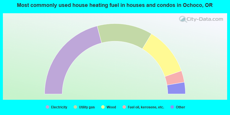
- 41.9%Electricity
- 25.5%Utility gas
- 22.0%Wood
- 5.3%Fuel oil, kerosene, etc.
- 3.7%Bottled, tank, or LP gas
- 1.6%Other fuel
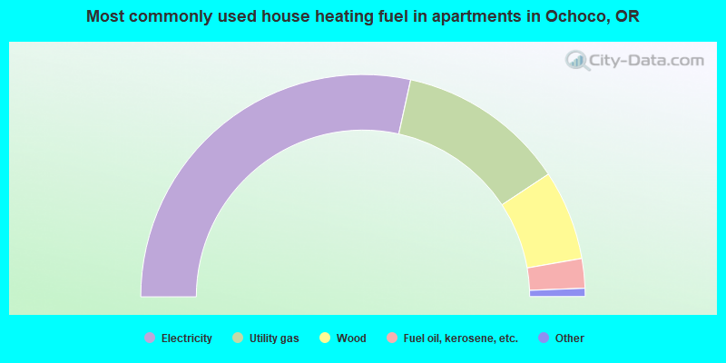
- 56.9%Electricity
- 24.5%Utility gas
- 13.1%Wood
- 4.3%Fuel oil, kerosene, etc.
- 0.9%Bottled, tank, or LP gas
- 0.4%Other fuel
Ochoco compared to Oregon state average:
- Unemployed percentage below state average.
- Black race population percentage significantly below state average.
- Hispanic race population percentage below state average.
- Foreign-born population percentage significantly below state average.
- Renting percentage significantly below state average.
- Length of stay since moving in significantly above state average.
- Number of rooms per house significantly below state average.
- House age significantly below state average.
- Institutionalized population percentage significantly above state average.
- Number of college students below state average.
- Percentage of population with a bachelor's degree or higher below state average.
Ochoco on our top lists:
- #1 on the list of "Top 101 cities with largest percentage of males in occupations: woodworkers (population 5,000+)"
- #1 on the list of "Top 101 cities with largest percentage of females in occupations: woodworkers (population 5,000+)"
- #1 on the list of "Top 101 cities with largest percentage of males in industries: motor vehicle and parts dealers (population 5,000+)"
- #1 on the list of "Top 101 cities with largest percentage of females in industries: wood products (population 5,000+)"
- #2 on the list of "Top 101 cities with largest percentage of males in industries: wood products (population 5,000+)"
- #3 on the list of "Top 101 cities with largest percentage of females in industries: motor vehicle and parts dealers (population 5,000+)"
- #16 on the list of "Top 101 cities with largest percentage of males in industries: motor vehicles, parts and supplies merchant wholesalers (population 5,000+)"
- #19 on the list of "Top 101 cities with largest percentage of males in occupations: laborers and material movers, hand (population 5,000+)"
- #29 on the list of "Top 101 cities with largest percentage of males in occupations: material moving workers except supervisors and laborers and material movers, hand (population 5,000+)"
- #30 on the list of "Top 101 cities with largest percentage of females in occupations: cooks and food preparation workers (population 5,000+)"
- #41 on the list of "Top 101 cities with the largest percentage of people in residential treatment centers for emotionally disturbed children (population 1,000+)"
- #43 on the list of "Top 101 cities with largest percentage of females in occupations: other transportation workers (population 5,000+)"
- #53 on the list of "Top 101 cities with largest percentage of males in industries: plastics and rubber products (population 5,000+)"
- #76 on the list of "Top 100 cities with largest land areas (pop. 5,000+)"
- #92 on the list of "Top 101 cities with the largest percentage of people in unknown juvenile institutions (population 1,000+)"