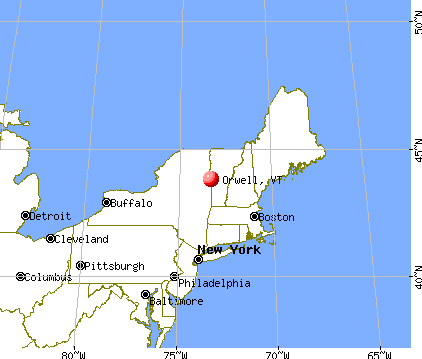
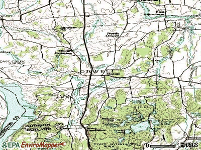
Orwell, Vermont
Submit your own pictures of this town and show them to the world
- OSM Map
- General Map
- Google Map
- MSN Map
Population change since 2000: +5.5%
 |
| Males: 616 | |
| Females: 634 |
| Median resident age: | 44.0 years |
| Vermont median age: | 45.8 years |
Zip codes: 05760.
| Orwell: | $81,537 |
| VT: | $73,991 |
Estimated per capita income in 2022: $43,499 (it was $19,835 in 2000)
Orwell town income, earnings, and wages data
Estimated median house or condo value in 2022: $346,902 (it was $115,800 in 2000)
| Orwell: | $346,902 |
| VT: | $304,700 |
Mean prices in 2022: all housing units: $400,302; detached houses: $427,258; townhouses or other attached units: $389,241; in 2-unit structures: $373,341; in 3-to-4-unit structures: $633,103; in 5-or-more-unit structures: $292,995; mobile homes: $101,709
Detailed information about poverty and poor residents in Orwell, VT


- 1,21797.4%White alone
- 80.6%Asian alone
- 80.6%Two or more races
- 60.5%American Indian alone
- 60.5%Hispanic
- 30.2%Black alone
- 20.2%Other race alone

Races in Orwell detailed stats: ancestries, foreign born residents, place of birth
According to our research of Vermont and other state lists, there were 4 registered sex offenders living in Orwell, Vermont as of May 23, 2024.
The ratio of all residents to sex offenders in Orwell is 313 to 1.
 Recent articles from our blog. Our writers, many of them Ph.D. graduates or candidates, create easy-to-read articles on a wide variety of topics.

 | If you moved to VT from another place, let us know what your experience was here (161 replies) |
| Significant differences between upstate NY and VT? (76 replies) |
| Lake Champlain (10 replies) |
| Vermont Weather (3779 replies) |
| Looking to move to NE Region... (5 replies) |
| Mysterious house in Vergennes (27 replies) |
Latest news from Orwell, VT collected exclusively by city-data.com from local newspapers, TV, and radio stations
Ancestries: English (17.4%), Irish (15.6%), French (15.2%), French Canadian (13.7%), German (11.4%), United States (9.5%).
Current Local Time: EST time zone
Elevation: 379 feet
Land area: 47.4 square miles.
Population density: 26 people per square mile (very low).
39 residents are foreign born (1.7% North America, 1.6% Europe).
| This town: | 3.3% |
| Vermont: | 3.8% |
| Orwell town: | 1.5% ($1,680) |
| Vermont: | 2.0% ($2,196) |
Nearest city with pop. 50,000+: Schenectady, NY  (76.7 miles , pop. 61,821).
Nearest city with pop. 200,000+: Boston, MA (151.2 miles , pop. 589,141).
Nearest city with pop. 1,000,000+: Bronx, NY (207.0 miles , pop. 1,332,650).
Nearest cities:
), ), ), ), Latitude: 43.81 N, Longitude: 73.28 W
Area code: 802


Single-family new house construction building permits:
- 2022: 2 buildings, average cost: $259,200
- 2021: 2 buildings, average cost: $259,200
- 2020: 3 buildings, average cost: $248,200
- 2019: 1 building, cost: $249,800
- 2018: 1 building, cost: $249,800
- 2017: 4 buildings, average cost: $248,100
- 2016: 4 buildings, average cost: $246,000
- 2015: 4 buildings, average cost: $226,800
- 2014: 2 buildings, average cost: $211,200
- 2013: 2 buildings, average cost: $193,300
- 2012: 4 buildings, average cost: $184,000
- 2011: 4 buildings, average cost: $172,800
- 2010: 2 buildings, average cost: $165,900
- 2009: 1 building, cost: $178,900
- 2008: 4 buildings, average cost: $100,000
- 2007: 7 buildings, average cost: $181,200
- 2006: 14 buildings, average cost: $171,000
- 2005: 5 buildings, average cost: $108,400
- 2004: 6 buildings, average cost: $108,400
- 2003: 3 buildings, average cost: $108,400
- 2002: 5 buildings, average cost: $108,400
- 2000: 23 buildings, average cost: $108,400
- 1999: 9 buildings, average cost: $86,600
- 1998: 7 buildings, average cost: $86,600
- 1997: 8 buildings, average cost: $86,600


| Here: | 2.1% |
| Vermont: | 2.0% |


- Agriculture, forestry, fishing & hunting (17.4%)
- Educational services (12.0%)
- Health care (10.3%)
- Construction (8.2%)
- Professional, scientific, technical services (3.4%)
- Accommodation & food services (2.8%)
- Social assistance (2.8%)

- Agriculture, forestry, fishing & hunting (25.8%)
- Construction (14.6%)
- Educational services (6.7%)
- Truck transportation (4.3%)
- Health care (2.7%)
- Professional, scientific, technical services (2.4%)
- Wood products (2.4%)

- Health care (19.2%)
- Educational services (18.1%)
- Agriculture, forestry, fishing & hunting (7.5%)
- Social assistance (5.0%)
- Professional, scientific, technical services (4.6%)
- Computer & electronic products (3.9%)
- Public administration (3.6%)

- Farmers and farm managers (8.5%)
- Agricultural workers, including supervisors (6.9%)
- Driver/sales workers and truck drivers (5.4%)
- Other office and administrative support workers, including supervisors (5.1%)
- Other production occupations, including supervisors (4.8%)
- Preschool, kindergarten, elementary, and middle school teachers (4.1%)
- Other management occupations, except farmers and farm managers (2.8%)

- Farmers and farm managers (12.5%)
- Agricultural workers, including supervisors (11.6%)
- Driver/sales workers and truck drivers (9.4%)
- Other production occupations, including supervisors (4.9%)
- Carpenters (4.6%)
- Electrical equipment mechanics and other installation, maintenance, and repair workers, including supervisors (4.0%)
- Other office and administrative support workers, including supervisors (3.6%)

- Preschool, kindergarten, elementary, and middle school teachers (8.2%)
- Other office and administrative support workers, including supervisors (6.8%)
- Bookkeeping, accounting, and auditing clerks (5.0%)
- Other production occupations, including supervisors (4.6%)
- Health technologists and technicians (4.3%)
- Farmers and farm managers (3.9%)
- Other teachers, instructors, education, training, and library occupations (3.6%)
Average climate in Orwell, Vermont
Based on data reported by over 4,000 weather stations


(lower is better)

Air Quality Index (AQI) level in 2022 was 56.9. This is better than average.
| City: | 56.9 |
| U.S.: | 72.6 |

Carbon Monoxide (CO) [ppm] level in 2022 was 0.251. This is about average. Closest monitor was 20.4 miles away from the city center.
| City: | 0.251 |
| U.S.: | 0.251 |

Nitrogen Dioxide (NO2) [ppb] level in 2022 was 6.51. This is worse than average. Closest monitor was 20.4 miles away from the city center.
| City: | 6.51 |
| U.S.: | 5.11 |

Sulfur Dioxide (SO2) [ppb] level in 2022 was 0.299. This is significantly better than average. Closest monitor was 16.5 miles away from the city center.
| City: | 0.299 |
| U.S.: | 1.515 |

Ozone [ppb] level in 2022 was 23.5. This is significantly better than average. Closest monitor was 15.2 miles away from the city center.
| City: | 23.5 |
| U.S.: | 33.3 |

Particulate Matter (PM2.5) [µg/m3] level in 2022 was 7.23. This is about average. Closest monitor was 5.5 miles away from the city center.
| City: | 7.23 |
| U.S.: | 8.11 |
Tornado activity:
Orwell-area historical tornado activity is slightly below Vermont state average. It is 80% smaller than the overall U.S. average.
On 8/20/1968, a category F3 (max. wind speeds 158-206 mph) tornado 54.7 miles away from the Orwell town center injured one person and caused between $5000 and $50,000 in damages.
On 6/11/1976, a category F2 (max. wind speeds 113-157 mph) tornado 40.2 miles away from the town center caused between $50,000 and $500,000 in damages.
Earthquake activity:
Orwell-area historical earthquake activity is significantly above Vermont state average. It is 69% smaller than the overall U.S. average.On 4/20/2002 at 10:50:47, a magnitude 5.3 (5.3 ML, Depth: 3.0 mi, Class: Moderate, Intensity: VI - VII) earthquake occurred 52.8 miles away from the city center
On 10/7/1983 at 10:18:46, a magnitude 5.3 (5.1 MB, 5.3 LG, 5.1 ML) earthquake occurred 53.7 miles away from Orwell center
On 4/20/2002 at 10:50:47, a magnitude 5.2 (5.2 MB, 4.2 MS, 5.2 MW, 5.0 MW) earthquake occurred 51.7 miles away from the city center
On 1/19/1982 at 00:14:42, a magnitude 4.7 (4.5 MB, 4.7 MD, 4.5 LG, Class: Light, Intensity: IV - V) earthquake occurred 86.9 miles away from the city center
On 10/16/2012 at 23:12:25, a magnitude 4.7 (4.7 ML, Depth: 10.0 mi) earthquake occurred 132.2 miles away from Orwell center
On 6/17/1991 at 08:53:16, a magnitude 4.1 (4.0 MB, 4.0 LG, Depth: 3.1 mi) earthquake occurred 107.6 miles away from Orwell center
Magnitude types: regional Lg-wave magnitude (LG), body-wave magnitude (MB), duration magnitude (MD), local magnitude (ML), surface-wave magnitude (MS), moment magnitude (MW)
Natural disasters:
The number of natural disasters in Addison County (23) is greater than the US average (15).Major Disasters (Presidential) Declared: 16
Emergencies Declared: 3
Causes of natural disasters: Floods: 16, Storms: 15, Drought: 1, Heavy Rain: 1, Hurricane: 1, Ice Storm: 1, Landslide: 1, Snow: 1, Snowstorm: 1, Tornado: 1, Tropical Storm: 1, Wind: 1, Winter Storm: 1, Other: 1 (Note: some incidents may be assigned to more than one category).
Hospitals and medical centers near Orwell:
- MOSES-LUDINGTON HOSPITAL Critical Access Hospitals (about 9 miles away; TICONDEROGA, NY)
- HERITAGE COMMONS RESIDENTIAL HEALTH CARE (Nursing Home, about 9 miles away; TICONDEROGA, NY)
- HELEN PORTER HEALTHCARE AND REHAB (Nursing Home, about 15 miles away; MIDDLEBURY, VT)
- PORTER HOSPITAL, INC Critical Access Hospitals (about 15 miles away; MIDDLEBURY, VT)
- SAGER NURSING HOME, INC. (Nursing Home, about 16 miles away; FAIR HAVEN, VT)
Amtrak stations near Orwell:
- 7 miles: TICONDEROGA (RTE. 74 (FORT TICONDEROGA RD.)) . Services: enclosed waiting area, public restrooms, free short-term parking, free long-term parking, call for taxi service.
- 16 miles: FAIR HAVEN (DEPOT & WATER STS.)
- 18 miles: PORT HENRY (RTE. 9 NORTH & RTE. 22) . Services: enclosed waiting area, public restrooms, public payphones, free short-term parking, free long-term parking, call for car rental service, call for taxi service.
Colleges/universities with over 2000 students nearest to Orwell:
- Castleton State College (about 15 miles; Castleton, VT; Full-time enrollment: 2,079)
- Middlebury College (about 15 miles; Middlebury, VT; FT enrollment: 3,077)
- Adirondack Community College (about 37 miles; Queensbury, NY; FT enrollment: 2,826)
- Norwich University (about 39 miles; Northfield, VT; FT enrollment: 4,221)
- Champlain College (about 47 miles; Burlington, VT; FT enrollment: 2,623)
- University of Vermont (about 47 miles; Burlington, VT; FT enrollment: 11,566)
- Community College of Vermont (about 48 miles; Winooski, VT; FT enrollment: 3,394)
Public elementary/middle school in Orwell:
- ORWELL VILLAGE SCHOOL (Students: 151, Location: 494 MAIN STREET, Grades: KG-8)
Points of interest:
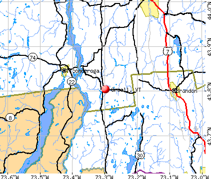
Notable locations in Orwell: Mud Dock (A), Orwell Bluff Light (B), Chipman Point Marina (C), North Orwell (D), Buoy 39 Marina (E), Chipmans Point Marina (F), Orwell Volunteer Fire Department (G). Display/hide their locations on the map
Cemeteries: Lakeview Cemetery (1), Choates Cemetery (2), Hack Cemetery (3), Peter Hall Cemetery (4), Mountain View Cemetery (5), North Cemetery (6), Saint Pauls Cemetery (7). Display/hide their locations on the map
Lakes and swamps: Choate Pond (A), Fortier Pond (B), Spruce Pond (C), Johnson Pond (D), Mud Pond (E), Conway Swamp (F). Display/hide their locations on the map
Streams, rivers, and creeks: Stacy Brook (A), Sanford Brook (B), Royce Brook (C), Pepper Brook (D), Little Lemon Fair River (E), Jones Brook (F), Big Brook (G), East Creek (H). Display/hide their locations on the map
Parks in Orwell include: East Creek Waterfowl Area (1), Richville Wildlife Management Area (2), Mount Independence State Historic Site (3), Pond Woods Wildlife Management Area (4). Display/hide their locations on the map
Birthplace of: George E. Royce - Businessman and state legislator, William Pitt Kellogg - Politician, Louis Winslow Austin - Physicist.
Drinking water stations with addresses in Orwell and their reported violations in the past:
ORWELL VILLAGE SCHOOL (Address: 494 MAIN STREET , Population served: 184, Groundwater):Past monitoring violations:CHIPMAN POINT MARINA (Address: 68 CHIPMAN POINT RD , Population served: 75, Groundwater):
- Follow-up Or Routine LCR Tap M/R - In JAN-01-1997, Contaminant: Lead and Copper Rule. Follow-up actions: St Violation/Reminder Notice (JUL-01-1997), St Compliance achieved (MAR-16-2011)
Past health violations:ECKERD YOUTH ALTERNATIVE INC (Address: 77 SINGING CEDARS RD , Population served: 54, Groundwater):Past monitoring violations:
- MCL, Monthly (TCR) - In JUL-2011, Contaminant: Coliform. Follow-up actions: St Tech Assistance Visit (JUL-07-2011), St Formal NOV issued (JUL-07-2011), St Public Notif requested (JUL-07-2011), St Boil Water Order (JUL-07-2011), St Compliance achieved (JUL-25-2011)
- MCL, Monthly (TCR) - In JUL-2009, Contaminant: Coliform. Follow-up actions: St Boil Water Order (JUL-08-2009), St Formal NOV issued (JUL-08-2009), St Tech Assistance Visit (JUL-08-2009), St Public Notif requested (JUL-08-2009), St Compliance achieved (AUG-09-2010)
- MCL, Monthly (TCR) - Between JUL-2006 and SEP-2006, Contaminant: Coliform. Follow-up actions: St Public Notif requested (SEP-27-2006), St Boil Water Order (SEP-27-2006), St Formal NOV issued (SEP-27-2006), St Tech Assistance Visit (SEP-27-2006), St Compliance achieved (JUN-07-2007), St Public Notif received (2 times from JUN-07-2007 to JUN-07-2007)
- Monitoring, Repeat Major (TCR) - Between JUL-2008 and SEP-2008, Contaminant: Coliform (TCR). Follow-up actions: St Formal NOV issued (OCT-22-2008), St Public Notif requested (OCT-22-2008), St Compliance achieved (AUG-09-2010)
- One routine major monitoring violation
- One minor monitoring violation
- One regular monitoring violation
Past health violations:ORWELL GAS N GO (Address: 330 VT ROUTE 22A , Population served: 25, Groundwater):Past monitoring violations:
- MCL, Monthly (TCR) - In AUG-2008, Contaminant: Coliform. Follow-up actions: St Boil Water Order (AUG-19-2008), St Formal NOV issued (AUG-19-2008), St Tech Assistance Visit (AUG-19-2008), St Public Notif requested (AUG-19-2008), St Compliance achieved (AUG-09-2010)
- Monitoring, Repeat Major (TCR) - In NOV-2010, Contaminant: Coliform (TCR). Follow-up actions: St Public Notif requested (DEC-29-2010), St Formal NOV issued (DEC-29-2010), St Public Notif received (JAN-11-2011), St Compliance achieved (MAY-10-2012)
- Follow-up Or Routine LCR Tap M/R - In NOV-01-2008, Contaminant: Lead and Copper Rule. Follow-up actions: St Formal NOV issued (DEC-08-2008), St Tech Assistance Visit (DEC-08-2008), St Public Notif requested (DEC-08-2008), St Other (DEC-08-2008), St Public Notif received (DEC-14-2008)
- Monitoring, Repeat Major (TCR) - In OCT-2008, Contaminant: Coliform (TCR). Follow-up actions: St Formal NOV issued (NOV-21-2008), St Public Notif requested (NOV-21-2008), St Public Notif received (JUN-23-2009), St Compliance achieved (AUG-09-2010)
- Follow-up Or Routine LCR Tap M/R - In OCT-01-2008, Contaminant: Lead and Copper Rule. Follow-up actions: St Formal NOV issued (DEC-08-2008), St Tech Assistance Visit (DEC-08-2008), St Public Notif requested (DEC-08-2008), St Other (DEC-08-2008), St Public Notif received (DEC-14-2008)
- One routine major monitoring violation
- 2 minor monitoring violations
Past monitoring violations:
- One routine major monitoring violation
| This town: | 2.6 people |
| Vermont: | 2.3 people |
| This town: | 71.8% |
| Whole state: | 62.5% |
| This town: | 9.9% |
| Whole state: | 9.2% |
Likely homosexual households (counted as self-reported same-sex unmarried-partner households)
- Lesbian couples: 1.0% of all households
- Gay men: 0.2% of all households
| This town: | 10.4% |
| Whole state: | 9.4% |
| This town: | 2.1% |
| Whole state: | 3.6% |
Banks with branches in Orwell (2011 data):
- The First National Bank of Orwell: The First National Bank Of Orwell at 441 Main Street, branch established on 1863/01/01. Info updated 2010/06/02: Bank assets: $41.6 mil, Deposits: $37.7 mil, local headquarters, positive income, Mortgage Lending Specialization, 2 total offices
For population 15 years and over in Orwell:

- Never married: 19.1%
- Now married: 64.7%
- Separated: 1.2%
- Widowed: 4.8%
- Divorced: 10.2%
For population 25 years and over in Orwell:
- High school or higher: 81.5%
- Bachelor's degree or higher: 22.2%
- Graduate or professional degree: 6.9%
- Unemployed: 3.3%
- Mean travel time to work (commute): 23.9 minutes


| Here: | 12.1 |
| Vermont average: | 11.7 |
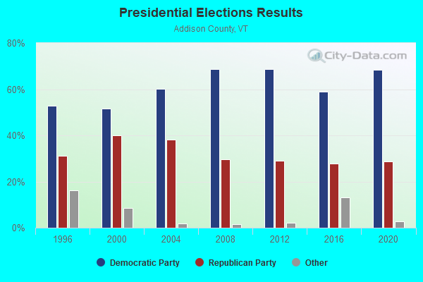
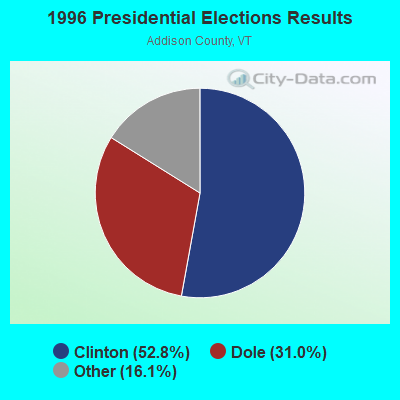

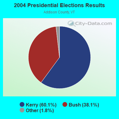
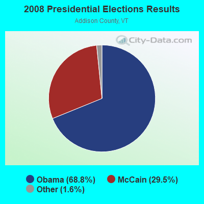
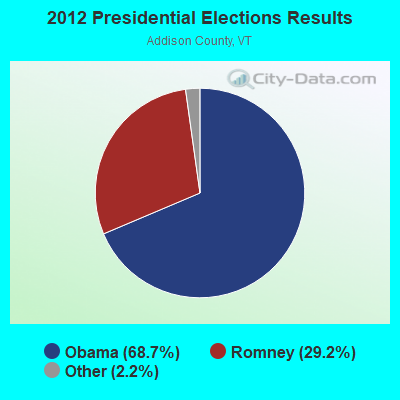
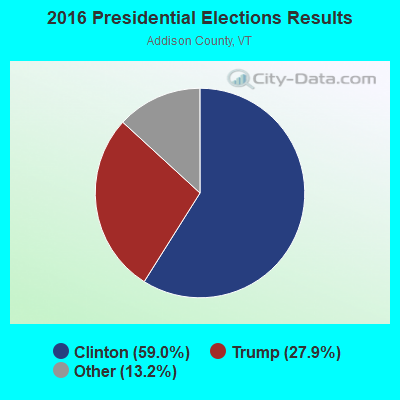
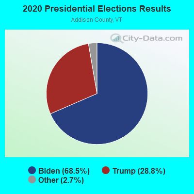
Graphs represent county-level data. Detailed 2008 Election Results
Religion statistics for Orwell, VT (based on Addison County data)
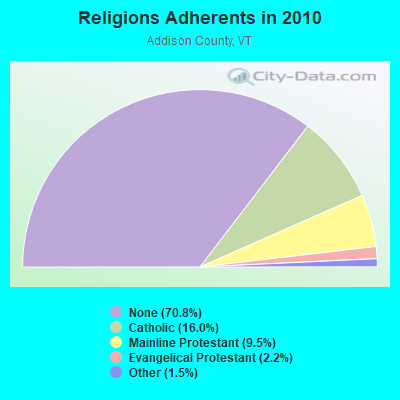
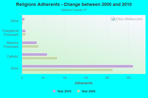
| Religion | Adherents | Congregations |
|---|---|---|
| Catholic | 5,892 | 6 |
| Mainline Protestant | 3,491 | 27 |
| Evangelical Protestant | 801 | 13 |
| Other | 560 | 6 |
| None | 26,077 | - |
Food Environment Statistics:
| This county: | 4.64 / 10,000 pop. |
| Vermont: | 3.84 / 10,000 pop. |
| Addison County: | 1.36 / 10,000 pop. |
| State: | 1.95 / 10,000 pop. |
| This county: | 6.55 / 10,000 pop. |
| State: | 6.40 / 10,000 pop. |
| Addison County: | 8.45 / 10,000 pop. |
| State: | 11.52 / 10,000 pop. |
| Addison County: | 5.8% |
| State: | 6.8% |
| This county: | 20.9% |
| State: | 22.3% |
| Here: | 9.1% |
| State: | 13.3% |
Strongest AM radio stations in Orwell:
- WIPS (1250 AM; 1 kW; TICONDEROGA, NY; Owner: CALVIN HUGH CARR)
- WGY (810 AM; 50 kW; SCHENECTADY, NY; Owner: CLEAR CHANNEL BROADCASTING LICENSES, INC.)
- WSYB (1380 AM; 5 kW; RUTLAND, VT; Owner: CAPSTAR TX LIMITED PARTNERSHIP)
- WCHP (760 AM; 35 kW; CHAMPLAIN, NY; Owner: CHAMPLAIN RADIO, INC.)
- WNNZ (640 AM; 50 kW; WESTFIELD, MA; Owner: CLEAR CHANNEL BROADCASTING LICENSES, INC.)
- WPTR (1540 AM; 50 kW; ALBANY, NY; Owner: KIMTRON, INC.)
- WICY (1490 AM; 50 kW; MALONE, NY; Owner: CARTIER COMMUNICATIONS INC.)
- WDEV (550 AM; 5 kW; WATERBURY, VT; Owner: RADIO VERMONT, INC.)
- WRKO (680 AM; 50 kW; BOSTON, MA; Owner: ENTERCOM BOSTON LICENSE, LLC)
- WCRN (830 AM; 50 kW; WORCESTER, MA; Owner: CARTER BROADCASTING CORPORATION)
- WFAD (1490 AM; 1 kW; MIDDLEBURY, VT; Owner: ADDISON BROADCASTING COMPANY, INC.)
- WVMT (620 AM; 5 kW; BURLINGTON, VT; Owner: SISON BROADCASTING, INC.)
- WEEI (850 AM; 50 kW; BOSTON, MA; Owner: ENTERCOM BOSTON LICENSE, LLC)
Strongest FM radio stations in Orwell:
- WEXP (101.5 FM; BRANDON, VT; Owner: VOX VERMONT, L.L.C.)
- WEBK (105.3 FM; KILLINGTON, VT; Owner: 6 JOHNSON ROAD LICENSES, INC.)
- WANC (103.9 FM; TICONDEROGA, NY; Owner: WAMC)
- WJJR (98.1 FM; RUTLAND, VT; Owner: 6 JOHNSON ROAD LICENSES, INC.)
- WZRT (97.1 FM; RUTLAND, VT; Owner: CAPSTAR TX LIMITED PARTNERSHIP)
- WGLV (91.7 FM; WOODSTOCK, VT; Owner: CHRISTIAN MINISTRIES INC)
- WHDQ-FM1 (106.1 FM; RUTLAND, VT; Owner: GREAT NORTHERN RADIO, L.L.C.)
- WJEN (94.5 FM; RUTLAND, VT; Owner: 6 JOHNSON ROAD LICENSES, INC.)
- WDEV-FM (96.1 FM; WARREN, VT; Owner: RADIO VERMONT, INC.)
- WWFY (100.9 FM; BERLIN, VT; Owner: VOX ALLEGANY, LLC)
- WEQX (102.7 FM; MANCHESTER, VT; Owner: NORTHSHIRE COMMUNICATIONS, INC.)
- WCVT (101.7 FM; STOWE, VT; Owner: RADIO VERMONT CLASSICS, L.L.C.)
- WJAN (95.1 FM; SUNDERLAND, VT; Owner: 6 JOHNSON ROAD LICENSES, INC.)
- WXLG (89.9 FM; NORTH CREEK, NY; Owner: THE ST. LAWRENCE UNIVERSITY)
- WVPS (107.9 FM; BURLINGTON, VT; Owner: VERMONT PUBLIC RADIO)
- WEZF (92.9 FM; BURLINGTON, VT; Owner: CAPSTAR TX LIMITED PARTNERSHIP)
- WLKC (103.3 FM; WATERBURY, VT; Owner: RADIO BROADCASTING SERVICES, INC.)
- WVPR (89.5 FM; WINDSOR, VT; Owner: VERMONT PUBLIC RADIO)
- WNCS (104.7 FM; MONTPELIER, VT; Owner: MONTPELIER BROADCASTING, INC.)
- WKBE (100.3 FM; WARRENSBURG, NY; Owner: 6 JOHNSON ROAD LICENSES, INC.)
TV broadcast stations around Orwell:
- WVER (Channel 28; RUTLAND, VT; Owner: VERMONT ETV, INC.)
- W61CE (Channel 61; RUTLAND, VT; Owner: MARGARET SANGUINETTI (ADMINISTRATRIX OF THE ESTATE))
- W67AW (Channel 67; TICONDEROGA, NY; Owner: MOUNTAIN LAKES PUB.TELECOMM.COUNCIL)
- Orwell, Vermont
- Fatal accident count11
- Vehicles involved in fatal accidents15
- Fatal accidents involving drunk persons:5
- Fatalities11
- Persons involved in fatal accidents28
- Pedestrians involved in fatal accidents0
- Vermont average
- Fatal accident count1030
- Vehicles involved in fatal accidents1421
- Fatal accidents involving drunk persons548
- Fatalities1151
- Persons involved in fatal accidents2527
- Pedestrians involved in fatal accidents20
- National Bridge Inventory (NBI) Statistics
- 5Number of bridges
- 26ft / 7.5mTotal length
- $698,000Total costs
- 990Total average daily traffic
- 35Total average daily truck traffic
- 1,041Total future (year 2027) average daily traffic
FCC Registered Broadcast Land Mobile Towers:
2- Knox Hill Road .1 Miles East Of Sunset Lake Road (Lat: 43.785278 Lon: -73.263611), Type: Tower, Structure height: 36.6 m, Call Sign: KIC442,
Assigned Frequencies: 154.385 MHz, Grant Date: 12/15/2021, Expiration Date: 02/02/2032, Registrant: Burlington Communications, 4735 Williston Rd Ste 30, Williston, VT 05495, Phone: (802) 862-7092, Email:
- Lat: 43.804500 Lon: -73.299111, Call Sign: WQSA902,
Assigned Frequencies: 72.1000 MHz, Grant Date: 08/23/2013, Expiration Date: 08/23/2023, Cancellation Date: 10/28/2023, Certifier: Patrick Walters, Registrant: Primex Wireless, Inc., 965 Wells Street, Lake Geneva, WI 53147, Phone: (800) 537-0464
FCC Registered Microwave Towers:
3- ORWELL, 18 Knox Hill Road (Lat: 43.786083 Lon: -73.263639), Type: Ltower, Structure height: 45.7 m, Overall height: 50 m, Call Sign: WQRB432,
Assigned Frequencies: 10755.0 MHz, Grant Date: 04/09/2013, Expiration Date: 04/09/2023, Cancellation Date: 11/05/2015, Certifier: Charles Cleary, Registrant: Verizon Wireless, 1120 Sanctuary Pkwy, #150 Gasa5reg, Alpharetta, GA 30009-7630, Phone: (770) 797-1070, Fax: (770) 797-1036, Email:
- ORWELL, 43.78608, -73.26366 (Lat: 43.786083 Lon: -73.263611), Type: Gtower, Structure height: 45.7 m, Call Sign: WQWK915,
Assigned Frequencies: 6093.45 MHz, 6093.45 MHz, 6034.15 MHz, 6093.45 MHz, 6034.15 MHz, 6093.45 MHz, 6034.15 MHz, 6093.45 MHz, 6034.15 MHz, 6093.45 MHz... (+12 more), Grant Date: 09/24/2015, Expiration Date: 09/24/2025, Certifier: Mr Phillip T Chitwood, Registrant: Vermont Transco, 366 Pinnacle Ridge Road, Rutland, VT 05701, Phone: (802) 772-3777, Email:
- ORWELL, Intersection Of Martin Hill Rd. And Knox Hill Rd. (Lat: 43.786083 Lon: -73.263667), Type: Gtower, Structure height: 45.8 m, Overall height: 50 m, Call Sign: WRNL758,
Assigned Frequencies: 6063.80 MHz, 6123.10 MHz, 6063.80 MHz, 6123.10 MHz, 6063.80 MHz, 6123.10 MHz, 6063.80 MHz, 6123.10 MHz, 6063.80 MHz, 6123.10 MHz... (+6 more), Grant Date: 07/23/2021, Expiration Date: 07/23/2031, Cancellation Date: 08/07/2023, Certifier: Christophe Le Scanve, Registrant: Cellco Partnership, 5055 North Point Pkwy, Np2ne Network Engineering, Alpharetta, GA 30022, Phone: (770) 797-1070, Email:
FCC Registered Amateur Radio Licenses:
4- Call Sign: KB1FRV, Licensee ID: L00285272, Grant Date: 12/07/2021, Expiration Date: 12/07/2031, Certifier: Maurice E Prior Iii, Registrant: Maurice E Prior Iii, 145 Royce Hill Road, Orwell, VT 05760
- Call Sign: KC1DKN, Licensee ID: L01930120, Grant Date: 03/19/2015, Expiration Date: 03/19/2025, Certifier: Charles F Eddy Iv, Registrant: Charles F Eddy Iv, 65 Sunset Lake Road, Orwell, VT 05760
- Call Sign: KC1DKO, Licensee ID: L01930121, Grant Date: 03/19/2015, Expiration Date: 03/19/2025, Certifier: Thomas B Eddy, Registrant: Thomas B Eddy, Orwell, VT 05760
- Call Sign: KC1HTD, Licensee ID: L01809356, Grant Date: 06/19/2017, Expiration Date: 06/19/2027, Cancellation Date: 08/21/2018, Certifier: Raymond B Mason, Registrant: Raymond B Mason, 187 Needham Hill Rd, Orwell, VT 05760
FAA Registered Aircraft:
3- Aircraft: CESSNA 150D (Category: Land, Seats: 2, Weight: Up to 12,499 Pounds, Speed: 90 mph), Engine: CONT MOTOR 0-200 SERIES (100 HP) (4 Cycle)
N-Number: 4288U, N4288U, N-4288U, Serial Number: 15060288, Year manufactured: 1964, Airworthiness Date: 01/13/1964, Certificate Issue Date: 07/20/1994
Registrant (Individual): Kenneth R Piper, 194 Fisher Rd, Orwell, VT 05760 - Aircraft: MAULE MX-7-180B (Category: Land, Seats: 5, Weight: Up to 12,499 Pounds), Engine: LYCOMING O-360-C1F (180 HP) (Reciprocating)
N-Number: 721LM, N721LM, N-721LM, Serial Number: 22022C, Year manufactured: 2006, Airworthiness Date: 01/15/2006, Certificate Issue Date: 11/24/2008
Registrant (LLC): Maynards Aviation LLC, 7 Old Foundry Rd, Orwell, VT 05760
Deregistered: Cancel Date: 05/06/2019 - Aircraft: PIPER PA-28-140 (Category: Land, Seats: 4, Weight: Up to 12,499 Pounds, Speed: 107 mph), Engine: LYCOMING 0-320 SERIES (180 HP) (Reciprocating)
N-Number: 7005R, N7005R, N-7005R, Serial Number: 28-21699, Year manufactured: 1966, Airworthiness Date: 05/02/1966, Certificate Issue Date: 06/20/2002
Registrant (Co-Owned): Paul H Maynard, 7 Old Foundry Rd, Orwell, VT 05760, Other Owners: Scharene A Maynard
Deregistered: Cancel Date: 01/08/2018

- 56.7%Fuel oil, kerosene, etc.
- 25.5%Wood
- 17.1%Bottled, tank, or LP gas
- 0.8%Utility gas

- 40.0%Bottled, tank, or LP gas
- 31.7%Wood
- 28.3%Fuel oil, kerosene, etc.
Orwell compared to Vermont state average:
- Unemployed percentage significantly below state average.
- Black race population percentage significantly below state average.
- Hispanic race population percentage significantly below state average.
- Renting percentage below state average.
- Length of stay since moving in significantly above state average.
- Number of rooms per house significantly below state average.
- House age significantly below state average.
- Number of college students significantly below state average.