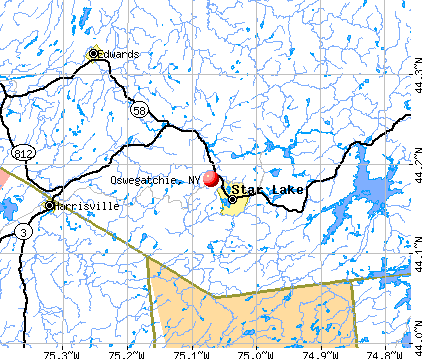
Oswegatchie, New York
Submit your own pictures of this town and show them to the world
- OSM Map
- General Map
- Google Map
- MSN Map
Population change since 2000: +0.6%
 |
| Males: 2,103 | |
| Females: 2,294 |
| Median resident age: | 44.3 years |
| New York median age: | 40.7 years |
Zip codes: 13669.
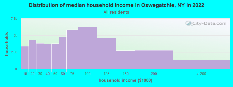
| Oswegatchie: | $67,696 |
| NY: | $79,557 |
Estimated per capita income in 2022: $29,826 (it was $16,236 in 2000)
Oswegatchie town income, earnings, and wages data
Estimated median house or condo value in 2022: $123,032 (it was $59,600 in 2000)
| Oswegatchie: | $123,032 |
| NY: | $400,400 |
Mean prices in 2022: all housing units: $165,040; detached houses: $170,732; townhouses or other attached units: $459,774; in 2-unit structures: $389,853; in 3-to-4-unit structures: $379,409; in 5-or-more-unit structures: $432,214; mobile homes: $74,789; occupied boats, rvs, vans, etc.: $95,045
Detailed information about poverty and poor residents in Oswegatchie, NY
Compare current foreclosures near Oswegatchie, NY:
| Photo | Address | Area | Beds / Baths | Price | Details |
|---|---|---|---|---|---|

|
#1
Gilbert St
Ogdensburg, NY 13669
|
783 sq. feet
|
1 baths 2 beds |
show details | |

|
#2
Harrison Ave
Ogdensburg, NY 13669
|
1,410 sq. feet
|
1 baths 3 beds |
show details | |

|
#3
Rosseel St
Ogdensburg, NY 13669
|
1,656 sq. feet
|
1 baths 3 beds |
show details | |

|
#4
Cold Springs Rd
Lisbon, NY 13658
|
1,470 sq. feet
|
1 baths 4 beds |
show details | |

|
#5
Haggert Rd
Ogdensburg, NY 13669
|
- sq. feet
|
- baths - beds |
show details | |

|
#6
Washington St
Ogdensburg, NY 13669
|
- sq. feet
|
- baths - beds |
show details | |

|
#7
Randall Rd
Lisbon, NY 13658
|
- sq. feet
|
- baths - beds |
show details | |

|
#8
County Route 10
De Peyster, NY 13633
|
780 sq. feet
|
- baths - beds |
show details | |

|
#9
State Highway 37
Ogdensburg, NY 13669
|
1,456 sq. feet
|
- baths - beds |
show details | |

|
#10
State Highway 37
Ogdensburg, NY 13669
|
- sq. feet
|
- baths - beds |
show details |
| Photo | Address | Area | Beds / Baths | Price | Details |
|---|---|---|---|---|---|

|
#11
County Route 17
De Kalb Junction, NY 13630
|
- sq. feet
|
- baths - beds |
show details | |

|
Check over 1 million property listings on Foreclosure.com!
|
browse all offers | |||

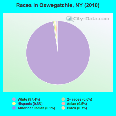
- 4,28397.4%White alone
- 280.6%Two or more races
- 280.6%Hispanic
- 210.5%American Indian alone
- 220.5%Asian alone
- 130.3%Black alone
- 10.02%Native Hawaiian and Other
Pacific Islander alone - 10.02%Other race alone
Races in Oswegatchie detailed stats: ancestries, foreign born residents, place of birth
According to our research of New York and other state lists, there were 2 registered sex offenders living in Oswegatchie, New York as of May 21, 2024.
The ratio of all residents to sex offenders in Oswegatchie is 2,199 to 1.
The ratio of registered sex offenders to all residents in this city is lower than the state average.
 Recent articles from our blog. Our writers, many of them Ph.D. graduates or candidates, create easy-to-read articles on a wide variety of topics.


 | Potsdam / Ogdensburg??? (7 replies) |
Latest news from Oswegatchie, NY collected exclusively by city-data.com from local newspapers, TV, and radio stations
Ancestries: French (18.4%), English (15.7%), Irish (14.4%), United States (11.3%), German (7.3%), French Canadian (7.2%).
Current Local Time: EST time zone
Elevation: 1372 feet
Land area: 65.8 square miles.
Population density: 67 people per square mile (very low).
84 residents are foreign born
| This town: | 1.9% |
| New York: | 20.4% |
| Oswegatchie town: | 2.2% ($1,337) |
| New York: | 1.9% ($2,847) |
Nearest city with pop. 50,000+: Utica, NY  (106.4 miles , pop. 60,651).
Nearest city with pop. 200,000+: Rochester, NY (147.1 miles , pop. 219,773).
Nearest city with pop. 1,000,000+: Bronx, NY (273.6 miles , pop. 1,332,650).
Nearest cities:
), ), ), ), )Latitude: 44.63 N, Longitude: 75.47 W
Area code commonly used in this area: 315

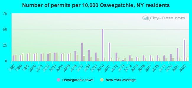
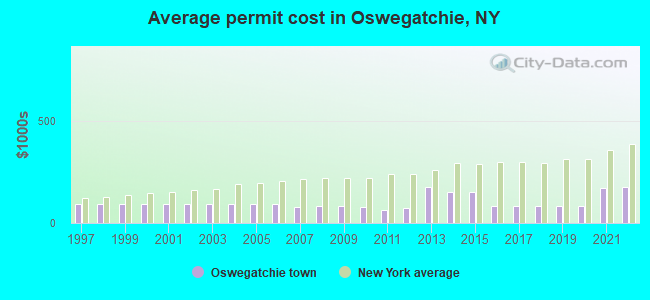
Single-family new house construction building permits:
- 2022: 15 buildings, average cost: $177,700
- 2021: 9 buildings, average cost: $172,800
- 2020: 5 buildings, average cost: $85,000
- 2019: 4 buildings, average cost: $85,000
- 2018: 4 buildings, average cost: $85,000
- 2017: 4 buildings, average cost: $85,000
- 2016: 4 buildings, average cost: $85,000
- 2015: 3 buildings, average cost: $149,100
- 2014: 4 buildings, average cost: $149,100
- 2013: 1 building, cost: $175,000
- 2012: 6 buildings, average cost: $71,300
- 2011: 13 buildings, average cost: $63,200
- 2010: 22 buildings, average cost: $78,500
- 2009: 6 buildings, average cost: $81,800
- 2008: 8 buildings, average cost: $82,100
- 2007: 13 buildings, average cost: $80,200
- 2006: 7 buildings, average cost: $95,400
- 2005: 5 buildings, average cost: $95,400
- 2004: 5 buildings, average cost: $95,400
- 2003: 6 buildings, average cost: $95,400
- 2002: 5 buildings, average cost: $95,400
- 2001: 5 buildings, average cost: $95,400
- 2000: 5 buildings, average cost: $95,400
- 1999: 5 buildings, average cost: $95,400
- 1998: 4 buildings, average cost: $95,400
- 1997: 4 buildings, average cost: $95,400
| Here: | 5.2% |
| New York: | 4.4% |
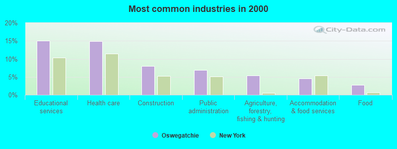
- Educational services (15.1%)
- Health care (14.9%)
- Construction (7.9%)
- Public administration (6.9%)
- Agriculture, forestry, fishing & hunting (5.3%)
- Accommodation & food services (4.5%)
- Food (2.8%)
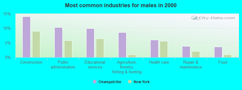
- Construction (14.1%)
- Public administration (10.4%)
- Educational services (10.0%)
- Agriculture, forestry, fishing & hunting (8.6%)
- Health care (6.0%)
- Repair & maintenance (3.9%)
- Food (3.7%)
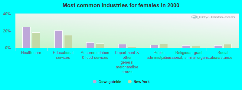
- Health care (24.5%)
- Educational services (20.6%)
- Accommodation & food services (6.5%)
- Department & other general merchandise stores (4.1%)
- Public administration (3.1%)
- Religious, grantmaking, civic, professional, similar organizations (3.0%)
- Social assistance (2.9%)
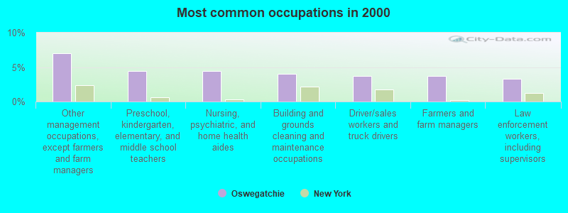
- Other management occupations, except farmers and farm managers (7.0%)
- Preschool, kindergarten, elementary, and middle school teachers (4.4%)
- Nursing, psychiatric, and home health aides (4.4%)
- Building and grounds cleaning and maintenance occupations (4.0%)
- Driver/sales workers and truck drivers (3.8%)
- Farmers and farm managers (3.7%)
- Law enforcement workers, including supervisors (3.3%)
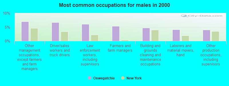
- Other management occupations, except farmers and farm managers (7.0%)
- Driver/sales workers and truck drivers (6.7%)
- Law enforcement workers, including supervisors (6.1%)
- Farmers and farm managers (5.4%)
- Building and grounds cleaning and maintenance occupations (4.8%)
- Laborers and material movers, hand (4.1%)
- Other production occupations, including supervisors (4.0%)
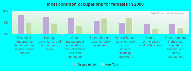
- Preschool, kindergarten, elementary, and middle school teachers (8.4%)
- Nursing, psychiatric, and home health aides (7.5%)
- Other management occupations, except farmers and farm managers (6.9%)
- Secretaries and administrative assistants (5.6%)
- Other office and administrative support workers, including supervisors (5.0%)
- Health technologists and technicians (4.4%)
- Other teachers, instructors, education, training, and library occupations (4.2%)
Average climate in Oswegatchie, New York
Based on data reported by over 4,000 weather stations


Earthquake activity:
Oswegatchie-area historical earthquake activity is significantly above New York state average. It is 72% smaller than the overall U.S. average.On 10/7/1983 at 10:18:46, a magnitude 5.3 (5.1 MB, 5.3 LG, 5.1 ML, Class: Moderate, Intensity: VI - VII) earthquake occurred 72.5 miles away from Oswegatchie center
On 4/20/2002 at 10:50:47, a magnitude 5.3 (5.3 ML, Depth: 3.0 mi) earthquake occurred 87.5 miles away from the city center
On 4/20/2002 at 10:50:47, a magnitude 5.2 (5.2 MB, 4.2 MS, 5.2 MW, 5.0 MW) earthquake occurred 86.6 miles away from Oswegatchie center
On 1/19/1982 at 00:14:42, a magnitude 4.7 (4.5 MB, 4.7 MD, 4.5 LG, Class: Light, Intensity: IV - V) earthquake occurred 207.3 miles away from Oswegatchie center
On 9/25/1998 at 19:52:52, a magnitude 5.2 (4.8 MB, 4.3 MS, 5.2 LG, 4.5 MW, Depth: 3.1 mi) earthquake occurred 330.2 miles away from the city center
On 10/16/2012 at 23:12:25, a magnitude 4.7 (4.7 ML, Depth: 10.0 mi) earthquake occurred 249.2 miles away from the city center
Magnitude types: regional Lg-wave magnitude (LG), body-wave magnitude (MB), duration magnitude (MD), local magnitude (ML), surface-wave magnitude (MS), moment magnitude (MW)
Natural disasters:
The number of natural disasters in St. Lawrence County (2) is a lot smaller than the US average (15).Major Disasters (Presidential) Declared: 1
Causes of natural disasters: Flood: 1, Other: 1 (Note: some incidents may be assigned to more than one category).
Hospitals and medical centers near Oswegatchie:
- UNITED HELPERS CARE (Hospital, about 4 miles away; HEUVELTON, NY)
- UNITED HELPERS CARE (Hospital, about 5 miles away; OGDENSBURG, NY)
- UNITED HELPERS CEDARS NURSING (Nursing Home, about 5 miles away; OGDENSBURG, NY)
- RIVER LEDGE HEALTH CARE AND REHABILITATION CENTER (Nursing Home, about 5 miles away; OGDENSBURG, NY)
- CLAXTON-HEPBURN MEDICAL CENTER Acute Care Hospitals (about 5 miles away; OGDENSBURG, NY)
- DR RAVINDER N AGARWAL (Dialysis Facility, about 5 miles away; OGDENSBURG, NY)
- ST JOSEPHS HOME (Nursing Home, about 6 miles away; OGDENSBURG, NY)
Colleges/universities with over 2000 students nearest to Oswegatchie:
- SUNY College of Technology at Canton (about 14 miles; Canton, NY; Full-time enrollment: 3,411)
- St Lawrence University (about 16 miles; Canton, NY; FT enrollment: 2,501)
- Clarkson University (about 24 miles; Potsdam, NY; FT enrollment: 3,472)
- SUNY College at Potsdam (about 25 miles; Potsdam, NY; FT enrollment: 4,307)
- Jefferson Community College (about 51 miles; Watertown, NY; FT enrollment: 2,886)
- SUNY College at Oswego (about 98 miles; Oswego, NY; FT enrollment: 7,550)
- SUNY College at Plattsburgh (about 99 miles; Plattsburgh, NY; FT enrollment: 5,934)
Points of interest:
Notable locations in Oswegatchie: Saint Lawrence State Park Golf Course (A), Ogdensburg Country Club (B), Northrup Corners (C), Eel Weir Picnic Area (D), Debyah Farms (E), Galilee Farms (F), Beggs Dairy Farms (G), Royal - J - Acres (H), Wilson Dairy (I), Fishel Farms (J), Heuvelton Village Water Pollution Control Plant (K), Cedars Nursing Home (L), Heuvelton Free Library (M), United Helpers Nursing Home (N), Pythian Home (O), Heuvelton Fire Department (P). Display/hide their locations on the map
Shopping Center: Seaway Shopping Center (1). Display/hide its location on the map
Churches in Oswegatchie include: Wesleyan Church (A), Stone Church (B). Display/hide their locations on the map
Cemeteries: Pine Hill Cemetery (1), Riverside Cemetery (2), Hill Crest Cemetery (3), Mount Lona Cemetery (4), Zophen Cemetery (5), Davies Cemetery (6), Notre Dame Cemetery (7). Display/hide their locations on the map
Creeks: Beaver Creek (A), Tibbits Creek (B), Lisbon Creek (C). Display/hide their locations on the map
Park in Oswegatchie: Saint Lawrence Park (1). Display/hide its location on the map
| This town: | 2.5 people |
| New York: | 2.6 people |
| This town: | 69.1% |
| Whole state: | 63.5% |
| This town: | 10.5% |
| Whole state: | 6.8% |
Likely homosexual households (counted as self-reported same-sex unmarried-partner households)
- Lesbian couples: 0.4% of all households
- Gay men: 0.3% of all households
| This town: | 11.6% |
| Whole state: | 14.6% |
| This town: | 4.2% |
| Whole state: | 7.4% |
28 people in group homes intended for adults in 2010
People in group quarters in Oswegatchie in 2000:
- 246 people in nursing homes
- 27 people in college dormitories (includes college quarters off campus)
- 24 people in other nonhousehold living situations
- 17 people in homes for the mentally retarded
For population 15 years and over in Oswegatchie:
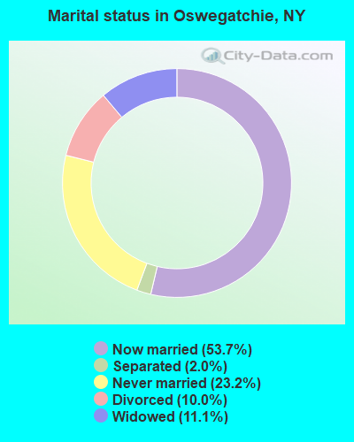
- Never married: 23.2%
- Now married: 53.7%
- Separated: 2.0%
- Widowed: 11.1%
- Divorced: 10.0%
For population 25 years and over in Oswegatchie:
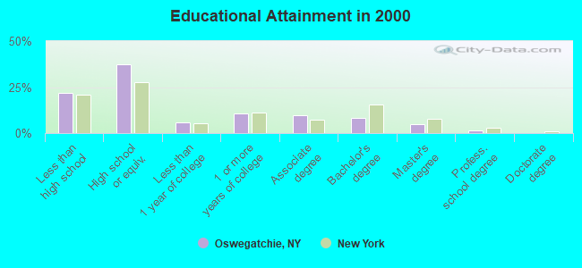
- High school or higher: 78.3%
- Bachelor's degree or higher: 14.5%
- Graduate or professional degree: 6.3%
- Unemployed: 6.4%
- Mean travel time to work (commute): 16.9 minutes
| Here: | 12.3 |
| New York average: | 14.2 |
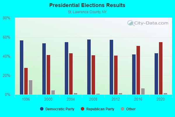
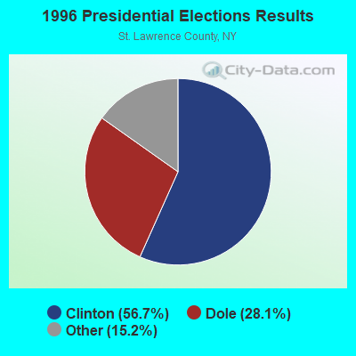
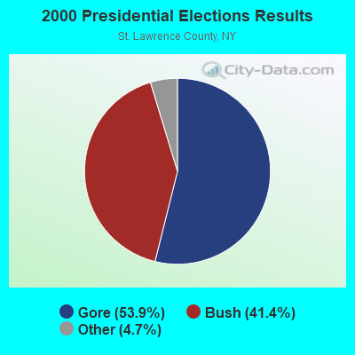
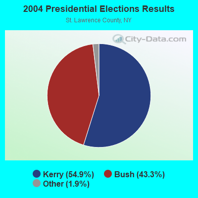
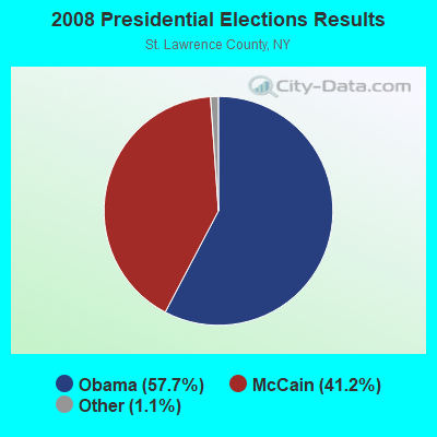
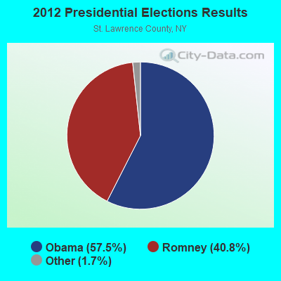
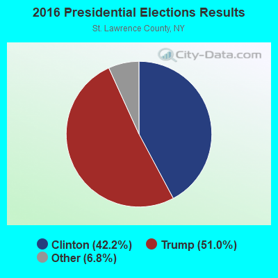
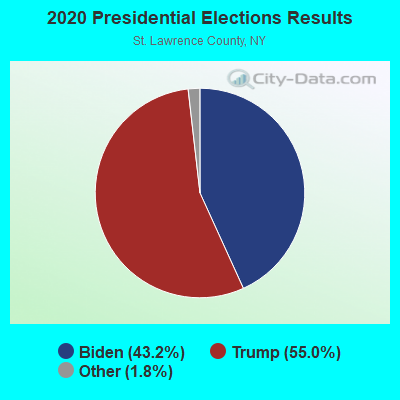
Graphs represent county-level data. Detailed 2008 Election Results
Religion statistics for Oswegatchie, NY (based on St. Lawrence County data)
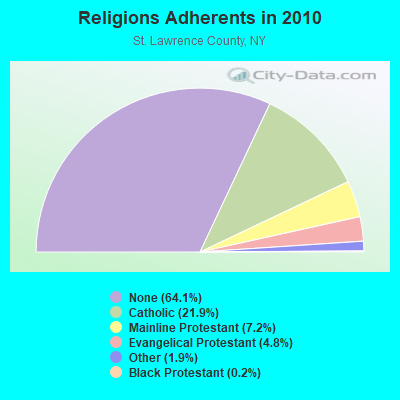
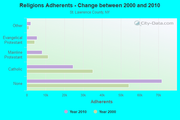
| Religion | Adherents | Congregations |
|---|---|---|
| Catholic | 24,478 | 32 |
| Mainline Protestant | 8,075 | 72 |
| Evangelical Protestant | 5,364 | 55 |
| Other | 2,093 | 11 |
| Black Protestant | 179 | 1 |
| None | 71,755 | - |
Food Environment Statistics:
| St. Lawrence County: | 2.55 / 10,000 pop. |
| New York: | 4.13 / 10,000 pop. |
| St. Lawrence County: | 0.09 / 10,000 pop. |
| State: | 0.06 / 10,000 pop. |
| St. Lawrence County: | 1.18 / 10,000 pop. |
| New York: | 0.92 / 10,000 pop. |
| Here: | 5.01 / 10,000 pop. |
| New York: | 1.68 / 10,000 pop. |
| Here: | 9.66 / 10,000 pop. |
| State: | 8.82 / 10,000 pop. |
| This county: | 8.5% |
| New York: | 8.2% |
| Here: | 29.6% |
| New York: | 23.8% |
| This county: | 13.3% |
| New York: | 15.6% |
Strongest AM radio stations in Oswegatchie:
- WSLB (1400 AM; 1 kW; OGDENSBURG, NY; Owner: CLANCY-MANCE COMMUNICATIONS NORTH, INC.)
- WICY (1490 AM; 50 kW; MALONE, NY; Owner: CARTIER COMMUNICATIONS INC.)
- WCHP (760 AM; 35 kW; CHAMPLAIN, NY; Owner: CHAMPLAIN RADIO, INC.)
- WGY (810 AM; 50 kW; SCHENECTADY, NY; Owner: CLEAR CHANNEL BROADCASTING LICENSES, INC.)
- WHAM (1180 AM; 50 kW; ROCHESTER, NY; Owner: CITICASTERS LICENSES, L.P.)
- WPDM (1470 AM; 1 kW; POTSDAM, NY; Owner: ST. LAWRENCE RADIO, INC.)
- WNNZ (640 AM; 50 kW; WESTFIELD, MA; Owner: CLEAR CHANNEL BROADCASTING LICENSES, INC.)
- WPTR (1540 AM; 50 kW; ALBANY, NY; Owner: KIMTRON, INC.)
- WNER (1410 AM; 5 kW; WATERTOWN, NY)
- WMCA (570 AM; 50 kW; NEW YORK, NY; Owner: SALEM MEDIA OF NEW YORK, LLC)
- WRKO (680 AM; 50 kW; BOSTON, MA; Owner: ENTERCOM BOSTON LICENSE, LLC)
- WCRN (830 AM; 50 kW; WORCESTER, MA; Owner: CARTER BROADCASTING CORPORATION)
- WFAN (660 AM; 50 kW; NEW YORK, NY; Owner: INFINITY BROADCASTING OPERATIONS, INC.)
Strongest FM radio stations in Oswegatchie:
- WNCQ-FM (102.9 FM; MORRISTOWN, NY; Owner: WATERS COMMUNICATIONS INC.)
- WBDB (92.7 FM; OGDENSBURG, NY; Owner: CLANCY-MANCE COMMUNICATIONS NORTH, INC.)
- W289AE (105.7 FM; OGDENSBURG, NY; Owner: GOOD NEWS RADIO, INC.)
- WYSX (98.7 FM; OGDENSBURG, NY; Owner: WATERS COMMUNICATIONS INC.)
- WRCD (101.5 FM; CANTON, NY; Owner: RADIO POWER INC.)
- WYUL (94.7 FM; CHATEAUGAY, NY; Owner: CARTIER COMMUNICATIONS INC.)
- WYSI (96.7 FM; CANTON, NY; Owner: RADIO POWER, INC.)
- WGIX-FM (95.3 FM; GOUVERNEUR, NY; Owner: CLANCY-MANCE COMMUNICATIONS NORTH, INC.)
- WSLU (89.5 FM; CANTON, NY; Owner: THE ST. LAWRENCE UNIVERSITY)
TV broadcast stations around Oswegatchie:
- WNPI-TV (Channel 18; NORWOOD, NY; Owner: ST. LAWRENCE VALLEY EDUCATIONAL TV COUNCIL, INC)
- National Bridge Inventory (NBI) Statistics
- 10Number of bridges
- 118ft / 35.7mTotal length
- $12,666,000Total costs
- 31,157Total average daily traffic
- 2,872Total average daily truck traffic
- 33,439Total future (year 2038) average daily traffic
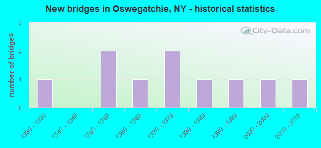
- New bridges - historical statistics
- 11930-1939
- 21950-1959
- 11960-1969
- 21970-1979
- 11980-1989
- 11990-1999
- 12000-2009
- 12010-2019
FCC Registered Cell Phone Towers:
2 (See the full list of FCC Registered Cell Phone Towers in Oswegatchie)FCC Registered Antenna Towers:
22 (See the full list of FCC Registered Antenna Towers)FCC Registered Microwave Towers:
2- STATION, Off Rt 58 (Lat: 44.221444 Lon: -75.075194), Overall height: 6.1 m, Call Sign: WNEU841,
Assigned Frequencies: 928.487 MHz, Grant Date: 10/29/1999, Expiration Date: 10/27/2009, Cancellation Date: 03/13/2000, Phone: (315) 428-5978
- WNCQ-FM Relay, Black Lake Road (Lat: 44.578611 Lon: -75.513889), Type: Tower, Structure height: 91 m, Overall height: 92 m, Call Sign: WQIS320,
Assigned Frequencies: 946.000 MHz, Grant Date: 04/29/2008, Expiration Date: 06/01/2030, Certifier: David Stephens, Registrant: Graham Brock, Inc., St. Simons Island, GA 31522-7466, Phone: (912) 638-8028, Fax: (912) 638-7722, Email:
FCC Registered Amateur Radio Licenses:
9 (See the full list of FCC Registered Amateur Radio Licenses in Oswegatchie)| Most common first names in Oswegatchie, NY among deceased individuals | ||
| Name | Count | Lived (average) |
|---|---|---|
| James | 5 | 78.2 years |
| Mary | 4 | 87.3 years |
| Ruth | 4 | 72.7 years |
| William | 4 | 78.2 years |
| George | 3 | 73.0 years |
| Kenneth | 3 | 64.6 years |
| Frederick | 2 | 64.9 years |
| Emily | 2 | 75.5 years |
| Bernice | 2 | 77.0 years |
| Bertha | 2 | 91.5 years |
| Most common last names in Oswegatchie, NY among deceased individuals | ||
| Last name | Count | Lived (average) |
|---|---|---|
| Kerr | 7 | 61.4 years |
| Ward | 5 | 80.4 years |
| Adams | 4 | 81.5 years |
| Marsh | 4 | 81.2 years |
| Hubbard | 3 | 76.0 years |
| Beach | 3 | 78.0 years |
| Durham | 3 | 66.0 years |
| Copeland | 3 | 66.6 years |
| Brownell | 3 | 78.0 years |
| Maccue | 3 | 83.3 years |
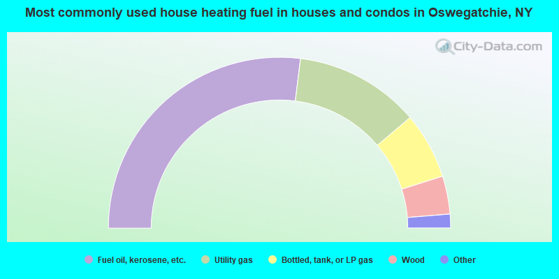
- 54.0%Fuel oil, kerosene, etc.
- 23.7%Utility gas
- 12.6%Bottled, tank, or LP gas
- 7.2%Wood
- 2.3%Electricity
- 0.3%Other fuel
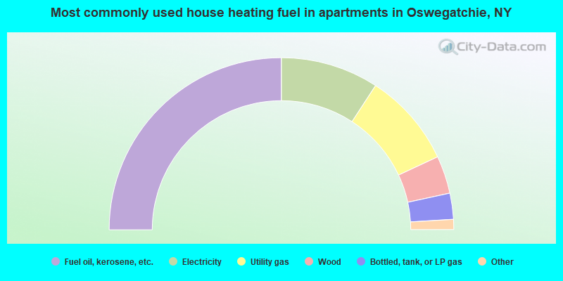
- 50.0%Fuel oil, kerosene, etc.
- 18.4%Electricity
- 17.7%Utility gas
- 7.1%Wood
- 4.9%Bottled, tank, or LP gas
- 1.1%Other fuel
- 0.8%No fuel used
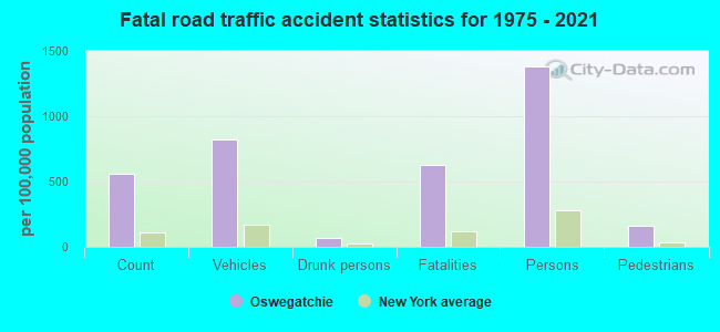
Oswegatchie compared to New York state average:
- Median house value significantly below state average.
- Unemployed percentage below state average.
- Black race population percentage significantly below state average.
- Hispanic race population percentage significantly below state average.
- Foreign-born population percentage significantly below state average.
- Renting percentage significantly below state average.
- Length of stay since moving in significantly above state average.
- Number of rooms per house significantly below state average.
- House age significantly below state average.
- Institutionalized population percentage above state average.
- Percentage of population with a bachelor's degree or higher below state average.