Palmerdale, Alabama
Submit your own pictures of this place and show them to the world
- OSM Map
- General Map
- Google Map
- MSN Map

| Males: 2,819 | |
| Females: 2,873 |
| Median resident age: | 36.1 years |
| Alabama median age: | 35.8 years |
Zip code: 35126
| Palmerdale: | $90,157 |
| AL: | $59,674 |
Estimated per capita income in 2022: $40,459 (it was $21,411 in 2000)
Palmerdale CCD income, earnings, and wages data
Estimated median house or condo value in 2022: $293,471 (it was $109,000 in 2000)
| Palmerdale: | $293,471 |
| AL: | $200,900 |
Mean prices in 2022: all housing units: $309,295; detached houses: $322,061; townhouses or other attached units: $218,406; in 2-unit structures: $208,395; in 3-to-4-unit structures: $229,321; in 5-or-more-unit structures: $282,627; mobile homes: $67,878; occupied boats, rvs, vans, etc.: $104,744
Detailed information about poverty and poor residents in Palmerdale, AL
Compare current foreclosures near Palmerdale, AL:
| Photo | Address | Area | Beds / Baths | Price | Details |
|---|---|---|---|---|---|

|
#1
Sun Valley Rd
Birmingham, AL 35215
|
4,071 sq. feet
|
2 baths 5 beds |
$117,900
|
show details |

|
#2
1st Pl NW
Birmingham, AL 35215
|
1,524 sq. feet
|
2 baths 3 beds |
$189,900
|
show details |

|
#3
Warrior Trafford Rd
Trafford, AL 35172
|
1,040 sq. feet
|
1 baths 3 beds |
$147,500
|
show details |

|
#4
Art Hanes Blvd
Birmingham, AL 35213
|
1,328 sq. feet
|
3 baths 4 beds |
$218,280
|
show details |

|
#5
Valley Crest Dr
Birmingham, AL 35215
|
1,088 sq. feet
|
1 baths 2 beds |
$99,900
|
show details |

|
#6
Carlisle Dr
Birmingham, AL 35235
|
1,985 sq. feet
|
2 baths 3 beds |
$177,900
|
show details |

|
#7
Mccormick Ave
Birmingham, AL 35215
|
880 sq. feet
|
1 baths 3 beds |
$79,000
|
show details |

|
#8
Martinwood Ln
Birmingham, AL 35235
|
1,459 sq. feet
|
2 baths 3 beds |
$84,000
|
show details |

|
#9
Elm Ave
Birmingham, AL 35217
|
1,180 sq. feet
|
1 baths 3 beds |
show details | |

|
#10
Elkwood Dr
Fultondale, AL 35068
|
1,746 sq. feet
|
2 baths 3 beds |
show details |
| Photo | Address | Area | Beds / Baths | Price | Details |
|---|---|---|---|---|---|

|
#11
74th St N
Birmingham, AL 35206
|
1,194 sq. feet
|
1 baths 3 beds |
show details | |

|
#12
Brewer Ln
Pinson, AL 35126
|
1,982 sq. feet
|
3 baths 3 beds |
show details | |

|
#13
Strawbridge Ln
Odenville, AL 35120
|
875 sq. feet
|
1 baths 2 beds |
show details | |

|
#14
Sutherland Rd
Mount Olive, AL 35117
|
1,509 sq. feet
|
1 baths 3 beds |
show details | |

|
#15
Crawford Rd
Mount Olive, AL 35117
|
1,421 sq. feet
|
1 baths 3 beds |
show details | |

|
#16
Heritage Pl
Birmingham, AL 35210
|
- sq. feet
|
3 baths 3 beds |
show details | |

|
#17
Sunrise Dr
Moody, AL 35004
|
1,191 sq. feet
|
3 baths 3 beds |
show details | |

|
#18
Amaro Cir
Moody, AL 35004
|
1,252 sq. feet
|
2 baths 4 beds |
show details | |

|
#19
73rd St N
Birmingham, AL 35206
|
840 sq. feet
|
1 baths 2 beds |
show details | |

|
#20
Winterpark Cir
Birmingham, AL 35215
|
1,476 sq. feet
|
2 baths 3 beds |
show details |
| Photo | Address | Area | Beds / Baths | Price | Details |
|---|---|---|---|---|---|

|
#21
50th Ave N
Birmingham, AL 35217
|
1,488 sq. feet
|
2 baths 3 beds |
show details | |

|
#22
Harness Cir
Pinson, AL 35126
|
1,491 sq. feet
|
5 baths 4 beds |
show details | |

|
#23
Whitney Dr
Pinson, AL 35126
|
1,578 sq. feet
|
2 baths 3 beds |
show details | |

|
#24
Bradford Trafford Rd
Pinson, AL 35126
|
1,428 sq. feet
|
2 baths 3 beds |
show details | |

|
#25
Hines Ln
Pinson, AL 35126
|
1,700 sq. feet
|
2 baths 3 beds |
show details | |

|
#26
41st Ave N
Birmingham, AL 35217
|
1,482 sq. feet
|
1 baths 3 beds |
show details | |

|
#27
Clairmont Dr
Leeds, AL 35094
|
2,050 sq. feet
|
3 baths 4 beds |
show details | |

|
#28
Greenwood St
Birmingham, AL 35217
|
2,255 sq. feet
|
1 baths 3 beds |
show details | |

|
#29
Summer Crest Dr
Pinson, AL 35126
|
2,145 sq. feet
|
2 baths 3 beds |
show details | |

|
#30
Ridgewood Rd
Fultondale, AL 35068
|
2,472 sq. feet
|
2 baths 4 beds |
show details |
| Photo | Address | Area | Beds / Baths | Price | Details |
|---|---|---|---|---|---|

|
#31
Cedar Grove Rd
Leeds, AL 35094
|
2,144 sq. feet
|
2 baths 3 beds |
show details | |

|
#32
Azalea Cir
Trussville, AL 35173
|
2,276 sq. feet
|
2 baths 4 beds |
show details | |

|
#33
1st Ave S
Birmingham, AL 35206
|
1,187 sq. feet
|
1 baths 3 beds |
show details | |

|
#34
Saddlebrook Cir
Birmingham, AL 35210
|
3,956 sq. feet
|
2 baths 3 beds |
show details | |

|
#35
1st Ave S
Birmingham, AL 35206
|
1,226 sq. feet
|
1 baths 3 beds |
show details | |

|
#36
Fieldstone Dr
Birmingham, AL 35215
|
1,125 sq. feet
|
2 baths 3 beds |
show details | |

|
#37
Roger Dr
Pinson, AL 35126
|
1,680 sq. feet
|
3 baths 6 beds |
show details | |

|
#38
Isbell Rd
Odenville, AL 35120
|
2,356 sq. feet
|
2 baths 3 beds |
show details | |

|
#39
5th St NE
Birmingham, AL 35215
|
2,301 sq. feet
|
2 baths 3 beds |
show details | |

|
#40
Sun Valley Rd
Birmingham, AL 35215
|
1,379 sq. feet
|
2 baths 3 beds |
show details |
| Photo | Address | Area | Beds / Baths | Price | Details |
|---|---|---|---|---|---|

|
#41
Woodbrook Rd
Birmingham, AL 35215
|
2,672 sq. feet
|
2 baths 4 beds |
show details | |

|
#42
Woodbrook Rd
Birmingham, AL 35215
|
4,844 sq. feet
|
2 baths 4 beds |
show details | |

|
#43
Pin Oak Ln
Odenville, AL 35120
|
1,940 sq. feet
|
2 baths 3 beds |
show details | |

|
#44
Parkwood Cir
Birmingham, AL 35215
|
2,230 sq. feet
|
3 baths 5 beds |
show details | |

|
#45
Hatfield Ln
Birmingham, AL 35215
|
1,227 sq. feet
|
1 baths 3 beds |
show details | |

|
#46
7th Pl NW
Birmingham, AL 35215
|
5,440 sq. feet
|
2 baths 4 beds |
show details | |

|
#47
Glenwood St NW
Birmingham, AL 35215
|
1,136 sq. feet
|
1 baths 3 beds |
show details | |

|
#48
Old Springville Rd
Birmingham, AL 35215
|
1,593 sq. feet
|
2 baths 3 beds |
show details | |

|
#49
13th Ave NW
Birmingham, AL 35215
|
1,157 sq. feet
|
1 baths 3 beds |
show details | |

|
Check over 1 million property listings on Foreclosure.com!
|
browse all offers | |||

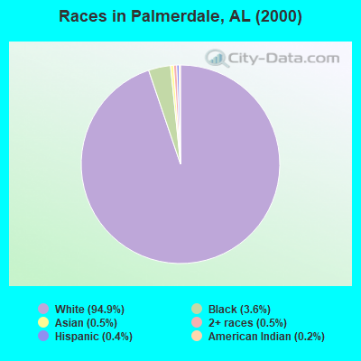
- 5,41194.9%White alone
- 2033.6%Black alone
- 270.5%Asian alone
- 270.5%Two or more races
- 200.4%Hispanic
- 90.2%American Indian alone
- 20.04%Other race alone
 Recent articles from our blog. Our writers, many of them Ph.D. graduates or candidates, create easy-to-read articles on a wide variety of topics.
Current Local Time: CST time zone
Elevation: 700 feet
Land area: 20.5 square miles.
Population density: 277 people per square mile (very low).

| Palmerdale CCD: | 0.4% ($481) |
| Alabama: | 0.4% ($289) |
Nearest city with pop. 50,000+: Birmingham, AL  (18.1 miles , pop. 242,820).
Nearest city with pop. 1,000,000+: Chicago, IL (562.8 miles , pop. 2,896,016).
Nearest cities:
), ), ), ), ), ), )Latitude: 33.75 N, Longitude: 86.64 W
Area code commonly used in this area: 205

| Here: | 2.6% |
| Alabama: | 2.6% |

- Health care (11.5%)
- Construction (7.7%)
- Public administration (6.5%)
- Finance & insurance (6.2%)
- Educational services (5.9%)
- Professional, scientific, technical services (5.2%)
- Motor vehicle & parts dealers (3.5%)
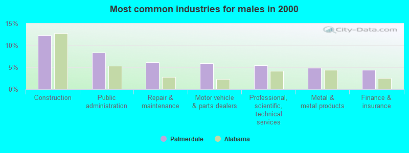
- Construction (12.3%)
- Public administration (8.4%)
- Repair & maintenance (6.1%)
- Motor vehicle & parts dealers (5.9%)
- Professional, scientific, technical services (5.5%)
- Metal & metal products (4.9%)
- Finance & insurance (4.4%)
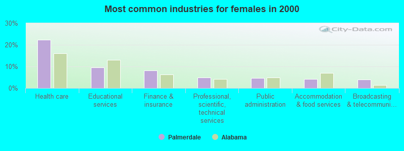
- Health care (22.3%)
- Educational services (9.5%)
- Finance & insurance (8.2%)
- Professional, scientific, technical services (4.9%)
- Public administration (4.6%)
- Accommodation & food services (4.2%)
- Broadcasting & telecommunications (4.0%)
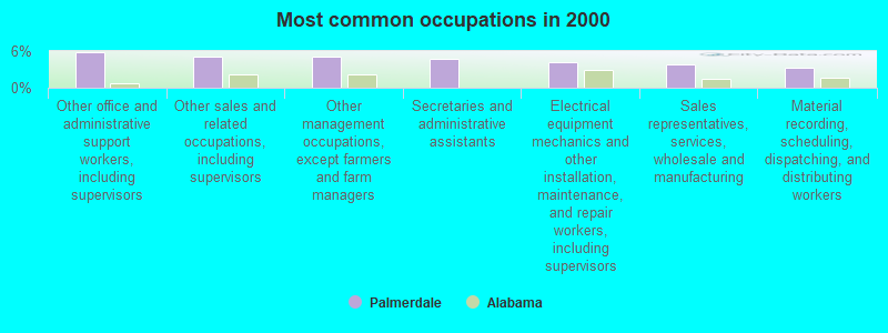
- Other office and administrative support workers, including supervisors (5.8%)
- Other sales and related occupations, including supervisors (5.1%)
- Other management occupations, except farmers and farm managers (5.0%)
- Secretaries and administrative assistants (4.7%)
- Electrical equipment mechanics and other installation, maintenance, and repair workers, including supervisors (4.1%)
- Sales representatives, services, wholesale and manufacturing (3.8%)
- Material recording, scheduling, dispatching, and distributing workers (3.2%)
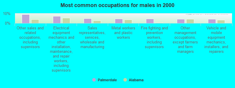
- Other sales and related occupations, including supervisors (9.1%)
- Electrical equipment mechanics and other installation, maintenance, and repair workers, including supervisors (7.3%)
- Sales representatives, services, wholesale and manufacturing (4.9%)
- Metal workers and plastic workers (4.4%)
- Fire fighting and prevention workers, including supervisors (4.4%)
- Other management occupations, except farmers and farm managers (4.4%)
- Vehicle and mobile equipment mechanics, installers, and repairers (4.1%)
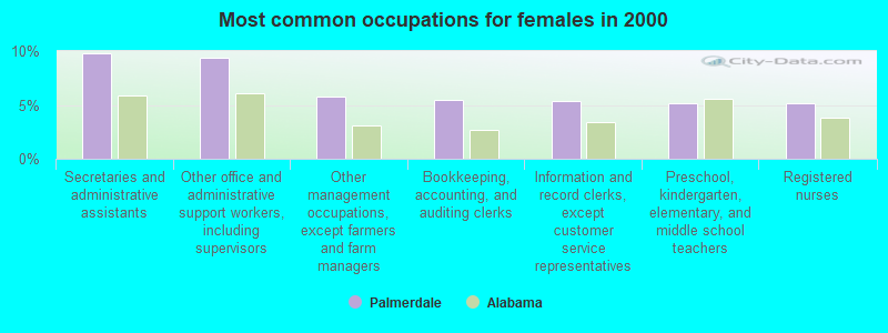
- Secretaries and administrative assistants (9.8%)
- Other office and administrative support workers, including supervisors (9.4%)
- Other management occupations, except farmers and farm managers (5.8%)
- Bookkeeping, accounting, and auditing clerks (5.5%)
- Information and record clerks, except customer service representatives (5.3%)
- Preschool, kindergarten, elementary, and middle school teachers (5.2%)
- Registered nurses (5.2%)
Average climate in Palmerdale, Alabama
Based on data reported by over 4,000 weather stations


(lower is better)
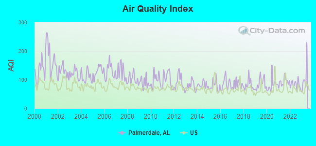
Air Quality Index (AQI) level in 2022 was 82.1. This is about average.
| City: | 82.1 |
| U.S.: | 72.6 |
Carbon Monoxide (CO) [ppm] level in 2022 was 0.202. This is better than average. Closest monitor was 14.9 miles away from the city center.
| City: | 0.202 |
| U.S.: | 0.251 |
Nitrogen Dioxide (NO2) [ppb] level in 2022 was 8.55. This is significantly worse than average. Closest monitor was 13.2 miles away from the city center.
| City: | 8.55 |
| U.S.: | 5.11 |
Sulfur Dioxide (SO2) [ppb] level in 2022 was 0.254. This is significantly better than average. Closest monitor was 10.0 miles away from the city center.
| City: | 0.254 |
| U.S.: | 1.515 |
Ozone [ppb] level in 2022 was 26.6. This is better than average. Closest monitor was 10.2 miles away from the city center.
| City: | 26.6 |
| U.S.: | 33.3 |
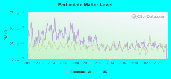
Particulate Matter (PM10) [µg/m3] level in 2022 was 19.3. This is about average. Closest monitor was 3.1 miles away from the city center.
| City: | 19.3 |
| U.S.: | 19.2 |
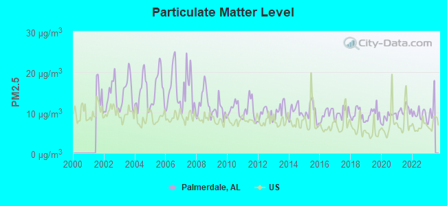
Particulate Matter (PM2.5) [µg/m3] level in 2022 was 9.57. This is about average. Closest monitor was 3.1 miles away from the city center.
| City: | 9.57 |
| U.S.: | 8.11 |
Tornado activity:
Palmerdale-area historical tornado activity is slightly above Alabama state average. It is 166% greater than the overall U.S. average.
On 4/4/1977, a category F5 (max. wind speeds 261-318 mph) tornado 10.6 miles away from the Palmerdale place center killed 22 people and injured 130 people and caused between $5,000,000 and $50,000,000 in damages.
On 4/8/1998, a category F5 tornado 17.3 miles away from the place center killed 32 people and injured 259 people and caused $200 million in damages.
Earthquake activity:
Palmerdale-area historical earthquake activity is significantly above Alabama state average. It is 132% greater than the overall U.S. average.On 1/18/1999 at 07:00:53, a magnitude 4.8 (4.8 MB, 4.0 LG, Depth: 0.6 mi, Class: Light, Intensity: IV - V) earthquake occurred 42.3 miles away from the city center
On 4/29/2003 at 08:59:39, a magnitude 4.9 (4.4 MB, 4.6 MW, 4.9 LG) earthquake occurred 77.9 miles away from the city center
On 4/29/2003 at 08:59:39, a magnitude 4.6 (4.6 MW, Depth: 12.3 mi) earthquake occurred 77.8 miles away from the city center
On 6/24/1975 at 11:11:36, a magnitude 4.5 (4.5 MB) earthquake occurred 68.8 miles away from the city center
On 10/24/1997 at 08:35:17, a magnitude 4.9 (4.8 MB, 4.2 MS, 4.9 LG, Depth: 6.2 mi) earthquake occurred 185.0 miles away from the city center
On 12/12/1997 at 08:42:20, a magnitude 4.0 (3.9 MB, 4.0 LG, Depth: 0.6 mi) earthquake occurred 42.7 miles away from the city center
Magnitude types: regional Lg-wave magnitude (LG), body-wave magnitude (MB), surface-wave magnitude (MS), moment magnitude (MW)
Natural disasters:
The number of natural disasters in Jefferson County (32) is a lot greater than the US average (15).Major Disasters (Presidential) Declared: 24
Emergencies Declared: 6
Causes of natural disasters: Storms: 18, Tornadoes: 16, Floods: 14, Hurricanes: 6, Winds: 6, Drought: 1, Fire: 1, Heavy Rain: 1, Snowfall: 1, Winter Storm: 1, Other: 1 (Note: some incidents may be assigned to more than one category).
Hospitals and medical centers near Palmerdale:
- SOUTHERN CARE BIRMINGHAM (Hospital, about 8 miles away; BIRMINGHAM, AL)
- DAVITA CENTER POINT DIALYSIS (Dialysis Facility, about 8 miles away; CENTER POINT, AL)
- BIRMINGHAM NURSING AND REHABILITATION CENTER EAST (Nursing Home, about 8 miles away; BIRMINGHAM, AL)
- GOLDEN LIVING CENTER - TRUSSVILLE (Nursing Home, about 10 miles away; TRUSSVILLE, AL)
- MAGNOLIA RIDGE CARE AND REHABILITATION CENTER (Nursing Home, about 11 miles away; GARDENDALE, AL)
- BIRMINGHAM EAST DIALYSIS (Dialysis Facility, about 12 miles away; BIRMINGHAM, AL)
- JEFFERSON CO NH (Nursing Home, about 12 miles away; BIRMINGHAM, AL)
Colleges/universities with over 2000 students nearest to Palmerdale:
- Jefferson State Community College (about 8 miles; Birmingham, AL; Full-time enrollment: 6,041)
- University of Alabama at Birmingham (about 20 miles; Birmingham, AL; FT enrollment: 14,853)
- Samford University (about 22 miles; Birmingham, AL; FT enrollment: 3,829)
- Virginia College-Birmingham (about 22 miles; Birmingham, AL; FT enrollment: 8,167)
- George C Wallace State Community College-Hanceville (about 25 miles; Hanceville, AL; FT enrollment: 4,486)
- Lawson State Community College-Birmingham Campus (about 25 miles; Birmingham, AL; FT enrollment: 2,695)
- Bevill State Community College (about 37 miles; Jasper, AL; FT enrollment: 2,970)
Points of interest:
Notable locations in Palmerdale: Emerald Valley Resort (A), Palmerdale Fire District (B). Display/hide their locations on the map
Churches in Palmerdale include: Palmerdale Presbyterian Church (A), Cedar Mount Baptist Church (B), First Baptist Church (C), Old Fashion Church (D), Masseyline Church (E), Agape Baptist Church (F), Hopewell Church (G), Village Springs Church (H). Display/hide their locations on the map
Reservoirs: Woodhaven Lake (A), Zamora Lake (B), Hilldale Farm Lake (C), Higginbothams Lake (D), Lake Sueann (E). Display/hide their locations on the map
Creek: Dry Creek (A). Display/hide its location on the map
| This place: | 2.7 people |
| Alabama: | 2.5 people |
| This place: | 79.8% |
| Whole state: | 67.8% |
| This place: | 2.7% |
| Whole state: | 4.7% |
Likely homosexual households (counted as self-reported same-sex unmarried-partner households)
- Lesbian couples: 0.3% of all households
- Gay men: 0.1% of all households
| This place: | 4.5% |
| Whole state: | 16.1% |
| This place: | 3.1% |
| Whole state: | 7.3% |
For population 15 years and over in Palmerdale:
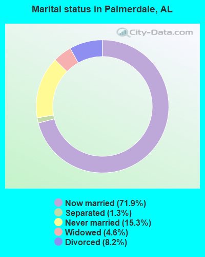
- Never married: 15.3%
- Now married: 71.9%
- Separated: 1.3%
- Widowed: 4.6%
- Divorced: 8.2%
For population 25 years and over in Palmerdale:
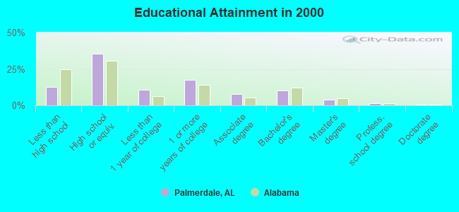
- High school or higher: 87.5%
- Bachelor's degree or higher: 16.2%
- Graduate or professional degree: 5.8%
- Unemployed: 2.4%
- Mean travel time to work (commute): 30.5 minutes
| Here: | 9.7 |
| Alabama average: | 13.2 |
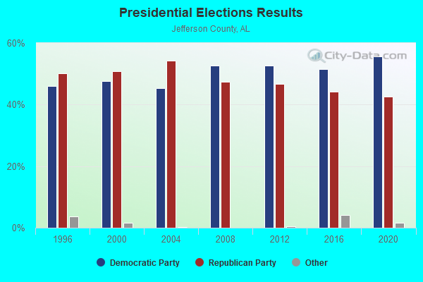
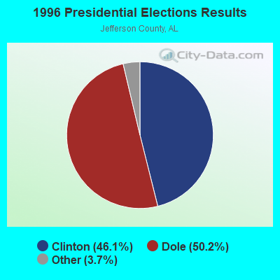
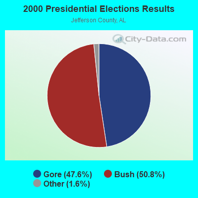

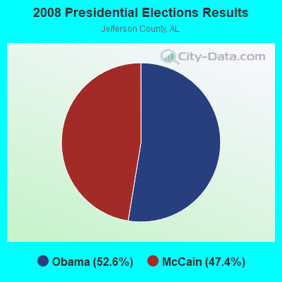
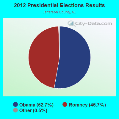
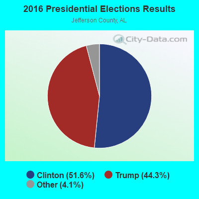
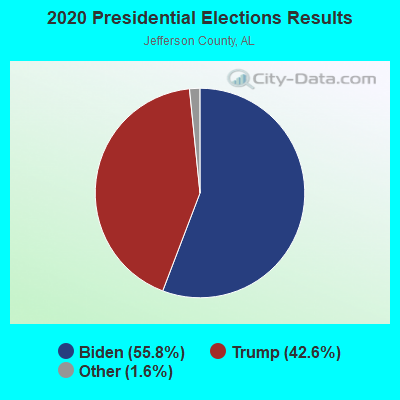
Graphs represent county-level data. Detailed 2008 Election Results
Religion statistics for Palmerdale, AL (based on Jefferson County data)
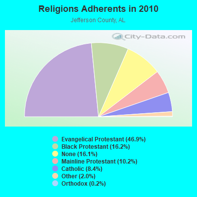
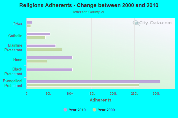
| Religion | Adherents | Congregations |
|---|---|---|
| Evangelical Protestant | 308,984 | 710 |
| Black Protestant | 106,653 | 257 |
| Mainline Protestant | 67,037 | 150 |
| Catholic | 55,083 | 32 |
| Other | 13,073 | 45 |
| Orthodox | 1,424 | 4 |
| None | 106,212 | - |
Food Environment Statistics:
| Jefferson County: | 2.05 / 10,000 pop. |
| Alabama: | 1.89 / 10,000 pop. |
| Jefferson County: | 0.18 / 10,000 pop. |
| State: | 0.20 / 10,000 pop. |
| This county: | 0.99 / 10,000 pop. |
| Alabama: | 0.65 / 10,000 pop. |
| Jefferson County: | 5.77 / 10,000 pop. |
| Alabama: | 6.32 / 10,000 pop. |
| Jefferson County: | 5.42 / 10,000 pop. |
| Alabama: | 5.75 / 10,000 pop. |
| This county: | 12.4% |
| Alabama: | 11.8% |
| Here: | 31.1% |
| Alabama: | 31.7% |
| Jefferson County: | 12.0% |
| Alabama: | 13.5% |
6.20% of this county's 2020 resident taxpayers moved to other counties in 2021 ($76,918 average adjusted gross income)
| Here: | 6.20% |
| Alabama average: | 6.41% |
0.01% of residents moved to foreign countries ($73 average AGI)
Jefferson County: 0.01% Alabama average: 0.02%
Top counties to which taxpayers relocated from this county between 2020 and 2021:
| to Shelby County, AL | |
| to St. Clair County, AL | |
| to Blount County, AL |
Strongest AM radio stations in Palmerdale:
- WDJC (850 AM; 50 kW; BIRMINGHAM, AL; Owner: KIMTRON, INC.)
- WAPI (1070 AM; 50 kW; BIRMINGHAM, AL; Owner: CITADEL BROADCASTING COMPANY)
- WJOX (690 AM; 50 kW; BIRMINGHAM, AL; Owner: CITADEL BROADCASTING COMPANY)
- WNSI (810 AM; 50 kW; JACKSONVILLE, AL; Owner: UNITED BROADCASTING NETWORK, INC.)
- WLPH (1480 AM; daytime; 5 kW; IRONDALE, AL; Owner: BIRMINGHAM CHRISTIAN RADIO, INC.)
- WERC (960 AM; 5 kW; BIRMINGHAM, AL; Owner: CAPSTAR TX LIMITED PARTNERSHIP)
- WYDE (1260 AM; 5 kW; BIRMINGHAM, AL; Owner: KIMTRON, INC.)
- WRJS (1320 AM; 5 kW; BIRMINGHAM, AL; Owner: CXR HOLDINGS, INC.)
- WFHK (1430 AM; 5 kW; PELL CITY, AL; Owner: STOCKS BROADCASTING, INC.)
- WKNG (1060 AM; daytime; 50 kW; TALLAPOOSA, GA; Owner: WKNG, INC.)
- WCOC (1010 AM; 5 kW; DORA, AL; Owner: AZTECA COMMUNICATIONS OF ALABAMA, INC.)
- WLOR (1550 AM; 50 kW; HUNTSVILLE, AL; Owner: BCA RADIO, LLC)
- WURL (760 AM; daytime; 1 kW; MOODY, AL; Owner: THE BILL DAVISON EVANGELISTIC ASSOC)
Strongest FM radio stations in Palmerdale:
- WRAX (107.7 FM; BIRMINGHAM, AL; Owner: CITADEL BROADCASTING COMPANY)
- WBPT (106.9 FM; BIRMINGHAM, AL; Owner: CXR HOLDINGS, INC.)
- WBHK (98.7 FM; WARRIOR, AL; Owner: CXR HOLDINGS, INC.)
- WZZK-FM (104.7 FM; BIRMINGHAM, AL; Owner: CXR HOLDINGS, INC.)
- WBHM (90.3 FM; BIRMINGHAM, AL; Owner: BD OF TRUSTEES/U OF AL AT BIRMINGHAM)
- WENN (105.9 FM; TRUSSVILLE, AL; Owner: CAPSTAR TX LIMITED PARTNERSHIP)
- WODL (97.3 FM; HOMEWOOD, AL; Owner: CXR HOLDINGS, INC.)
- WYSF (94.5 FM; BIRMINGHAM, AL; Owner: CITADEL BROADCASTING COMPANY)
- WYDE-FM (101.1 FM; CULLMAN, AL; Owner: KIMTRON, INC.)
- WMJJ (96.5 FM; BIRMINGHAM, AL; Owner: CAPSTAR TX LIMITED PARTNERSHIP)
- WQEN (103.7 FM; GADSDEN, AL; Owner: CAPSTAR TX LIMITED PARTNERSHIP)
- WGIB (91.9 FM; BIRMINGHAM, AL; Owner: GLEN IRIS BAPTIST SCHOOL)
- WDJC-FM (93.7 FM; BIRMINGHAM, AL; Owner: KIMTRON, INC.)
- WZRR (99.5 FM; BIRMINGHAM, AL; Owner: CITADEL BROADCASTING COMPANY)
- WJSR (91.1 FM; BIRMINGHAM, AL; Owner: JEFFERSON STATE COMMUNITY COLLEGE)
- WDXB (102.5 FM; JASPER, AL; Owner: CAPSTAR TX LIMITED PARTNERSHIP)
- WBFR (89.5 FM; BIRMINGHAM, AL; Owner: FAMILY STATIONS, INC.)
- WTBJ (91.3 FM; OXFORD, AL; Owner: TRINITY CHRISTIAN ACADEMY)
- WLJR (88.5 FM; BIRMINGHAM, AL; Owner: BRIARWOOD PRESBYTERIAN CHURCH)
- WKLD (97.7 FM; ONEONTA, AL; Owner: BLOUNT COUNTY BROADCASTING SERVICE INC.)
TV broadcast stations around Palmerdale:
- WTJP (Channel 60; GADSDEN, AL; Owner: TRINITY BROADCASTING NETWORK)
- WIAT (Channel 42; BIRMINGHAM, AL; Owner: MEDIA GENERAL COMMUNICATIONS, INC.)
- WBIQ (Channel 10; BIRMINGHAM, AL; Owner: ALABAMA EDUCATIONAL TELEVISION COMMISSION)
- WBRC (Channel 6; BIRMINGHAM, AL; Owner: WBRC LICENSE, INC.)
- WTTO (Channel 21; HOMEWOOD, AL; Owner: WTTO LICENSEE, LLC)
- WVTM-TV (Channel 13; BIRMINGHAM, AL; Owner: BIRMINGHAM BROADCASTING (WVTM-TV), LLC)
- WABM (Channel 68; BIRMINGHAM, AL; Owner: BIRMINGHAM (WABM-TV) LICENSEE, INC.)
- WJSU-TV (Channel 40; ANNISTON, AL; Owner: TV ALABAMA, INC.)
- WPXH (Channel 44; GADSDEN, AL; Owner: PAXSON COMMUNICATIONS LICENSE COMPANY, LLC)
- WDBB (Channel 17; BESSEMER, AL; Owner: WDBB-TV, INC.)
- WBXA-CA (Channel 2; BIRMINGHAM, AL; Owner: THE BOX WORLDWIDE LLC)
- WCFT-TV (Channel 33; TUSCALOOSA, AL; Owner: TV ALABAMA, INCORPORATED)
- W46DK (Channel 46; BIRMINGHAM, AL; Owner: TRINITY BROADCASTING NETWORK)
- W27CM (Channel 27; BIRMINGHAM, AL; Owner: EQUITY BROADCASTING CORPORATION)
- WBMA-LP (Channel 58; BIRMINGHAM, AL; Owner: TV ALABAMA, INC.)
- W34BI (Channel 34; BIRMINGHAM, AL; Owner: VENTANA TELEVISION, INC.)
FCC Registered Commercial Land Mobile Towers:
1- Wenn Tower Miles Mt (Lat: 33.731222 Lon: -86.632500), Structure height: 176 m, Call Sign: KPG416,
Assigned Frequencies: 455.010 MHz, Grant Date: 07/18/1986, Expiration Date: 04/01/2028, Registrant: Cumulus Media Inc., 3280 Peachtree Road, Nw, Suite 2300, Atlanta, GA 30305, Phone: (404) 260-6761, Fax: (404) 260-6961, Email:
FCC Registered Private Land Mobile Towers:
2- 4600 Clay Rd (Lat: 33.731222 Lon: -86.632500), Type: Tower, Structure height: 236 m, Overall height: 237 m, Call Sign: WPDX918,
Assigned Frequencies: 929.612 MHz, Grant Date: 06/29/1999, Expiration Date: 06/29/2009, Cancellation Date: 06/28/2001, Certifier: Donna Comer, Registrant: Paging Network Of America, Inc., 1500 International Pkwy, Suite 300, Richardson, TX 75081, Phone: (972) 801-0304, Fax: (972) 801-0330
- 4600 Clay Road (Lat: 33.731222 Lon: -86.632500), Type: Tower, Structure height: 236 m, Overall height: 237 m, Call Sign: WPIH605,
Assigned Frequencies: 929.587 MHz, Grant Date: 03/19/2001, Expiration Date: 09/08/2010, Cancellation Date: 07/09/2001, Certifier: Dick Smith, Registrant: Paging Network Of America Inc, 1500 International Parkway Suite 300, Richardson, TX 75081, Phone: (972) 801-8000, Fax: (972) 801-0330
FCC Registered Broadcast Land Mobile Towers:
1- 15 Twp 15 S Reange W Wenn Fm (Lat: 33.731222 Lon: -86.632500), Type: Building, Structure height: 5 m, Call Sign: WNWB966,
Assigned Frequencies: 5450.00 MHz, Grant Date: 03/11/2011, Expiration Date: 04/16/2021, Cancellation Date: 02/19/2021, Certifier: Jordan M Wertlieb, Registrant: Brooks, Pierce Et Al., Raleigh, NC 27602, Phone: (919) 839-0300, Fax: (919) 839-0304, Email:
FCC Registered Paging Towers:
3- 0.75mi. East Of 75/County Road 153 (Lat: 33.731194 Lon: -86.632472), Overall height: 176.5 m, Call Sign: WQZD502,
Assigned Frequencies: 931.937 MHz, Grant Date: 04/23/2019, Expiration Date: 04/01/2029, Certifier: J. Roy Pottle, Registrant: Wilkinson Barker Knauer, LLP, 1800 M Street, N.W., Suite 800n, Washington, DC 20036, Phone: (202) 783-4141, Fax: (202) 783-5851, Email:
- 4600 Clay Road (Lat: 33.731194 Lon: -86.632472), Structure height: 237 m, Overall height: 625 m, Call Sign: KNLP444,
Assigned Frequencies: 931.787 MHz, Expiration Date: 04/25/2005, Cancellation Date: 05/09/2003, Certifier: Paul H Kuzia, Registrant: Wilkinson Barker Knauer, LLP, 2300 N Street, N.W., 7th Floor, Washington, DC 20037, Phone: (202) 783-4141, Fax: (202) 783-5851, Email:
- Valley View Lane (Lat: 33.773889 Lon: -86.603889), Type: Tower, Structure height: 39.6 m, Overall height: 43 m, Call Sign: KIF650,
Assigned Frequencies: 931.812 MHz, Grant Date: 05/11/1999, Expiration Date: 04/01/2009, Cancellation Date: 11/12/2004, Certifier: Paul H Kuzia, Registrant: Wilkinson Barker Knauer, LLP, 2300 N Street, N.W., 7th Floor, Washington, DC 20037, Phone: (202) 783-4141, Fax: (202) 783-5851, Email:
FCC Registered Amateur Radio Licenses:
1- Call Sign: W4BSH, Grant Date: 05/24/1994, Expiration Date: 05/24/2004, Cancellation Date: 09/28/2001, Registrant: Thomas O Hicks, Palmerdale, AL 35123
FAA Registered Aircraft:
1- Aircraft: CESSNA 337G (Category: Land, Engines: 2, Seats: 6, Weight: Up to 12,499 Pounds, Speed: 142 mph), Engine: CONT MOTOR IO-360-G (210 HP) (Reciprocating)
N-Number: 72446, N72446, N-72446, Serial Number: 33701587, Year manufactured: 1973, Airworthiness Date: 03/05/1974, Certificate Issue Date: 04/13/2011
Registrant (LLC): Telaro LLC, Po Box 245, Palmerdale, AL 35123
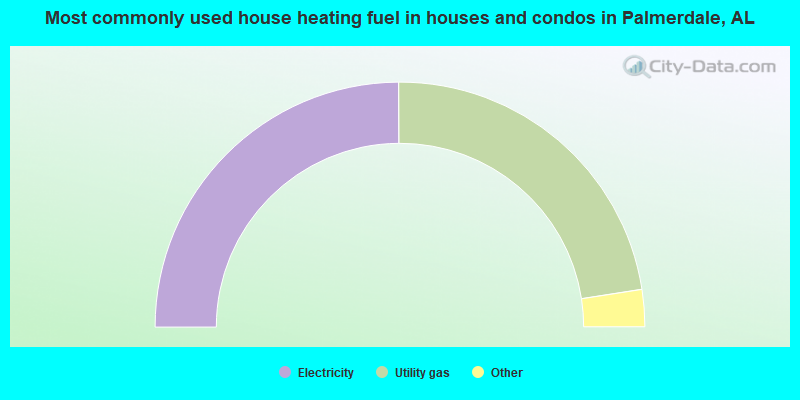
- 49.8%Electricity
- 45.2%Utility gas
- 3.3%Bottled, tank, or LP gas
- 1.1%Wood
- 0.6%Other fuel
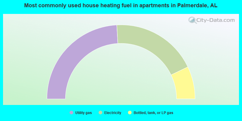
- 48.2%Utility gas
- 37.6%Electricity
- 14.2%Bottled, tank, or LP gas
Palmerdale compared to Alabama state average:
- Median household income above state average.
- Unemployed percentage significantly below state average.
- Black race population percentage significantly below state average.
- Hispanic race population percentage significantly below state average.
- Median age below state average.
- Foreign-born population percentage significantly below state average.
- Renting percentage significantly below state average.
- Length of stay since moving in significantly above state average.
- Number of rooms per house significantly below state average.
- House age significantly below state average.
Palmerdale on our top lists:
- #4 on the list of "Top 101 cities with largest percentage of males in industries: health and personal care, except drug, stores (population 5,000+)"
- #5 on the list of "Top 101 cities with largest percentage of males in industries: motor vehicle and parts dealers (population 5,000+)"
- #5 on the list of "Top 101 cities with largest percentage of females in industries: lumber and other construction materials merchant wholesalers (population 5,000+)"
- #6 on the list of "Top 101 cities with largest percentage of males in industries: paper and paper products merchant wholesalers (population 5,000+)"
- #12 on the list of "Top 101 cities with largest percentage of males in occupations: other sales and related workers including supervisors (population 5,000+)"
- #13 on the list of "Top 101 cities with largest percentage of males in industries: electrical and electronic goods merchant wholesalers (population 5,000+)"
- #18 on the list of "Top 101 cities with largest percentage of females in occupations: other healthcare support occupations (population 5,000+)"
- #21 on the list of "Top 101 cities with largest percentage of females in industries: broadcasting and telecommunications (population 5,000+)"
- #23 on the list of "Top 101 cities with largest percentage of females in industries: radio, tv, and computer stores (population 5,000+)"
- #24 on the list of "Top 101 cities with largest percentage of males in industries: vending machine operators (population 5,000+)"
- #25 on the list of "Top 101 cities with largest percentage of males in occupations: supervisors of transportation and material moving workers (population 5,000+)"
- #26 on the list of "Top 101 cities with largest percentage of males in occupations: special education teachers (population 5,000+)"
- #29 on the list of "Top 101 cities with largest percentage of males in industries: repair and maintenance (population 5,000+)"
- #30 on the list of "Top 101 cities with largest percentage of males in industries: warehousing and storage (population 5,000+)"
- #42 on the list of "Top 101 cities with largest percentage of males in industries: furniture and home furnishing merchant wholesalers (population 5,000+)"
- #43 on the list of "Top 101 cities with largest percentage of females in industries: machinery, equipment, and supplies merchant wholesalers (population 5,000+)"
- #44 on the list of "Top 101 cities with largest percentage of females in industries: furniture and related product manufacturing (population 5,000+)"
- #45 on the list of "Top 101 cities with largest percentage of females in occupations: bookkeeping, accounting, and auditing clerks (population 5,000+)"
- #56 on the list of "Top 101 cities with largest percentage of females in industries: music stores (population 5,000+)"
- #60 on the list of "Top 101 cities with largest percentage of males in industries: motor vehicles, parts and supplies merchant wholesalers (population 5,000+)"
- #5 on the list of "Top 101 counties with the highest number of infant deaths per 1000 residents 2007-2013 (pop. 50,000+)"
- #5 on the list of "Top 101 counties with the most Black Protestant adherents"
- #5 on the list of "Top 101 counties with the most Black Protestant congregations"
- #9 on the list of "Top 101 counties with the highest average weight of females"
- #9 on the list of "Top 101 counties with the most Evangelical Protestant adherents"