Papago, Arizona
Submit your own pictures of this place and show them to the world
- OSM Map
- General Map
- Google Map
- MSN Map

| Males: 4,237 | |
| Females: 4,562 |
| Median resident age: | 25.5 years |
| Arizona median age: | 34.2 years |
| Papago: | $29,656 |
| AZ: | $74,568 |
Estimated per capita income in 2022: $12,121 (it was $6,379 in 2000)
Papago CCD income, earnings, and wages data
Estimated median house or condo value in 2022: $106,285 (it was $34,400 in 2000)
| Papago: | $106,285 |
| AZ: | $402,800 |
Mean prices in 2022: all housing units: $358,231; detached houses: $392,439; townhouses or other attached units: $275,497; in 2-unit structures: over $1,000,000; in 3-to-4-unit structures: $210,654; in 5-or-more-unit structures: $246,614; mobile homes: $121,731; occupied boats, rvs, vans, etc.: $16,113
Detailed information about poverty and poor residents in Papago, AZ


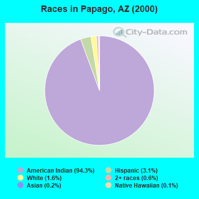
- 7,06394.3%American Indian alone
- 2313.1%Hispanic
- 1231.6%White alone
- 460.6%Two or more races
- 150.2%Asian alone
- 90.1%Native Hawaiian and Other
Pacific Islander alone - 50.07%Black alone
 Recent articles from our blog. Our writers, many of them Ph.D. graduates or candidates, create easy-to-read articles on a wide variety of topics.
Current Local Time: MST (no DST) time zone
Elevation: 666 feet
Land area: 3774.7 square miles.
Population density: 2.3 people per square mile (very low).

| Papago CCD: | 0.7% ($255) |
| Arizona: | 0.9% ($962) |
Nearest city with pop. 50,000+: Arivaca, AZ  (49.8 miles , pop. 50,441).
Nearest city with pop. 200,000+: Tucson, AZ (64.0 miles , pop. 486,699).
Nearest city with pop. 1,000,000+: Phoenix, AZ (105.0 miles , pop. 1,321,045).
Nearest cities:
Latitude: 32.01 N, Longitude: 111.98 W
Area code commonly used in this area: 520

| Here: | 3.6% |
| Arizona: | 3.8% |
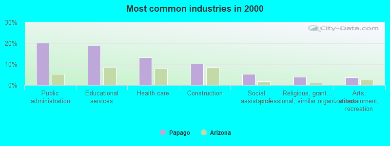
- Public administration (20.3%)
- Educational services (18.9%)
- Health care (13.3%)
- Construction (10.3%)
- Social assistance (5.4%)
- Religious, grantmaking, civic, professional, similar organizations (4.0%)
- Arts, entertainment, recreation (3.7%)
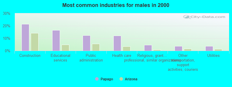
- Construction (21.5%)
- Educational services (16.6%)
- Public administration (12.3%)
- Health care (12.0%)
- Religious, grantmaking, civic, professional, similar organizations (4.6%)
- Other transportation, support activities, couriers (3.8%)
- Utilities (3.8%)
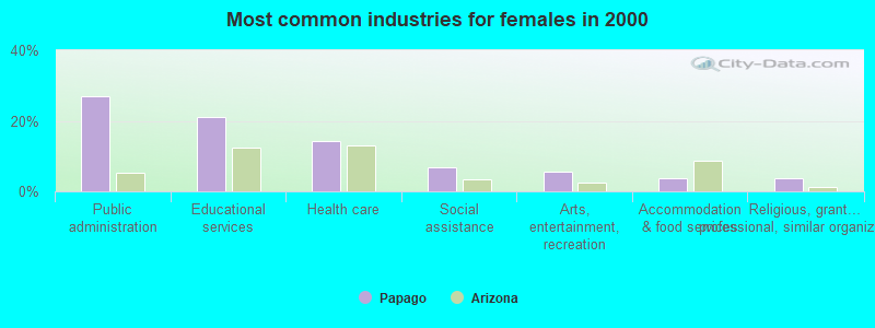
- Public administration (27.1%)
- Educational services (21.0%)
- Health care (14.3%)
- Social assistance (6.8%)
- Arts, entertainment, recreation (5.4%)
- Accommodation & food services (3.7%)
- Religious, grantmaking, civic, professional, similar organizations (3.6%)
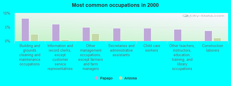
- Building and grounds cleaning and maintenance occupations (8.1%)
- Information and record clerks, except customer service representatives (6.1%)
- Other management occupations, except farmers and farm managers (5.0%)
- Secretaries and administrative assistants (4.6%)
- Child care workers (4.6%)
- Other teachers, instructors, education, training, and library occupations (4.3%)
- Construction laborers (3.7%)
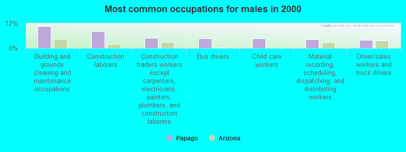
- Building and grounds cleaning and maintenance occupations (10.4%)
- Construction laborers (8.0%)
- Construction traders workers except carpenters, electricians, painters, plumbers, and construction laborers (4.9%)
- Bus drivers (4.7%)
- Child care workers (4.6%)
- Material recording, scheduling, dispatching, and distributing workers (4.1%)
- Driver/sales workers and truck drivers (3.9%)
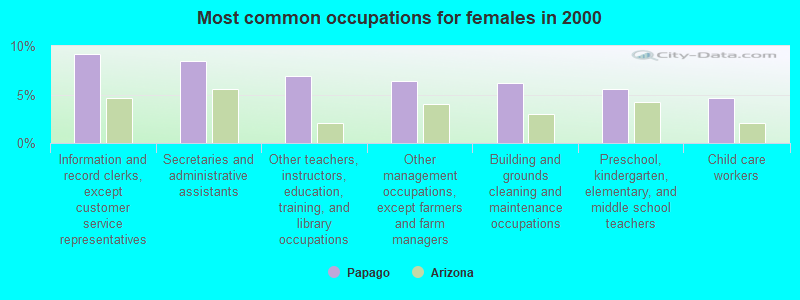
- Information and record clerks, except customer service representatives (9.2%)
- Secretaries and administrative assistants (8.5%)
- Other teachers, instructors, education, training, and library occupations (6.9%)
- Other management occupations, except farmers and farm managers (6.4%)
- Building and grounds cleaning and maintenance occupations (6.2%)
- Preschool, kindergarten, elementary, and middle school teachers (5.6%)
- Child care workers (4.6%)
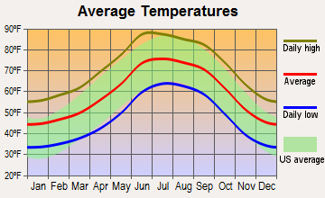
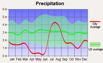
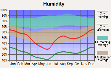
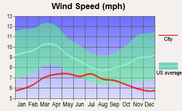
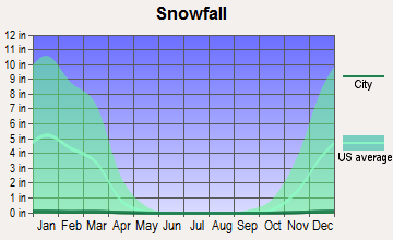
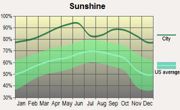
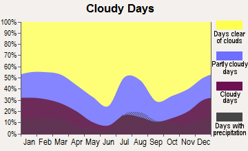
Average climate in Papago, Arizona
Based on data reported by over 4,000 weather stations
Earthquake activity:
Papago-area historical earthquake activity is significantly above Arizona state average. It is 1915% greater than the overall U.S. average.On 6/28/1992 at 11:57:34, a magnitude 7.6 (6.2 MB, 7.6 MS, 7.3 MW, Depth: 0.7 mi, Class: Major, Intensity: VIII - XII) earthquake occurred 303.3 miles away from the city center, causing 3 deaths (1 shaking deaths, 2 other deaths) and 400 injuries, causing $100,000,000 total damage and $40,000,000 insured losses
On 5/19/1940 at 04:36:40, a magnitude 7.2 (7.2 UK) earthquake occurred 231.9 miles away from the city center, causing $33,000,000 total damage
On 12/31/1934 at 18:45:56, a magnitude 7.1 (7.1 UK) earthquake occurred 225.5 miles away from the city center
On 10/15/1979 at 23:16:54, a magnitude 7.0 (5.7 MB, 6.9 MS, 7.0 ML, 6.4 MW) earthquake occurred 220.5 miles away from the city center
On 10/16/1999 at 09:46:44, a magnitude 7.4 (6.3 MB, 7.4 MS, 7.2 MW, 7.3 ML) earthquake occurred 310.2 miles away from the city center
On 11/24/1987 at 13:15:56, a magnitude 6.7 (6.0 MB, 6.6 MS, 6.7 ML, 6.1 ML, Class: Strong, Intensity: VII - IX) earthquake occurred 242.7 miles away from the city center
Magnitude types: body-wave magnitude (MB), local magnitude (ML), surface-wave magnitude (MS), moment magnitude (MW)
Natural disasters:
The number of natural disasters in Pima County (13) is near the US average (15).Major Disasters (Presidential) Declared: 10
Emergencies Declared: 1
Causes of natural disasters: Floods: 9, Storms: 8, Fires: 2, Hurricane: 1, Tornado: 1, Other: 1 (Note: some incidents may be assigned to more than one category).
Colleges/universities with over 2000 students nearest to Papago:
- University of Arizona (about 63 miles; Tucson, AZ; Full-time enrollment: 36,324)
- Pima Medical Institute-Tucson (about 65 miles; Tucson, AZ; FT enrollment: 2,357)
- Pima Community College (about 66 miles; Tucson, AZ; FT enrollment: 18,794)
- Central Arizona College (about 69 miles; Coolidge, AZ; FT enrollment: 4,893)
- Chandler-Gilbert Community College (about 90 miles; Chandler, AZ; FT enrollment: 8,047)
- Arizona State University-Polytechnic (about 92 miles; Mesa, AZ; FT enrollment: 3,311)
- South Mountain Community College (about 95 miles; Phoenix, AZ; FT enrollment: 2,736)
Points of interest:
Notable locations in Papago: Covered Wells (A), Tatnick (B), Manuels Well (C), Bibyak (D), Picacho (E), Kots Kug (F), Garcia Ranch (G), Cumahauti (H), Gu Kui Chuchg (I), Bam Boo Ranch (J), Quijotoa Trading Post (K), Kitt Peak National Observatory (L), Kohi Kug (M), Kots Kug Ranch (N), San Ignacio Ranch (O), San Juan Spring (P), Santa Rosa Trading Post (Q), Chui Vaya (R), Chicli Vo (S), Allison Camp (T). Display/hide their locations on the map
Churches in Papago include: Gu Achi Childrens Shrine (A), Our Lady of Guadalupe Mission (B), Queen of Angels Mission (C), Saint Agatha Mission (D), Saint Francis Mission (E), Saint Theresa Mission (F), San Solano Mission (G), Our Lady of Lourdes Mission (H). Display/hide their locations on the map
Cemeteries: Gunsight Cemetery (1), Santa Rosa Francisco Cemetery (2). Display/hide their locations on the map
Lakes and reservoirs: Chagit Vo (A), Menagers Lake (B), Francis Tank (C), Gohke Tank (D), Havana Tank (E), Kuke Chehedagi Tank (F), Bird Nest Tank (G), Mule Shoe Tank (H). Display/hide their locations on the map
Streams, rivers, and creeks: Sil Nakya Wash (A), Sikul Himatk Wash (B), Gu Vo Wash (C), Sells Wash (D), Murk Kui Wash (E), Mulberry Wash (F), San Vicente Wash (G), San Simon Wash (H), Comobabi Wash (I). Display/hide their locations on the map
Parks in Papago include: Vopolo Havoka (1), Rotary Park (2). Display/hide their locations on the map
| This place: | 3.7 people |
| Arizona: | 2.6 people |
| This place: | 54.4% |
| Whole state: | 68.2% |
| This place: | 15.9% |
| Whole state: | 6.2% |
Likely homosexual households (counted as self-reported same-sex unmarried-partner households)
- Lesbian couples: 0.5% of all households
- Gay men: 0.2% of all households
| This place: | 50.5% |
| Whole state: | 13.9% |
| This place: | 30.8% |
| Whole state: | 6.2% |
People in group quarters in Papago in 2000:
- 12 people in homes for abused, dependent, and neglected children
- 11 people in other types of correctional institutions
- 9 people in unknown juvenile institutions
- 8 people in other noninstitutional group quarters
- 3 people in hospitals/wards and hospices for chronically ill
- 3 people in other hospitals or wards for chronically ill
- 3 people in religious group quarters
For population 15 years and over in Papago:
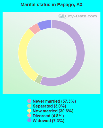
- Never married: 57.3%
- Now married: 30.6%
- Separated: 3.0%
- Widowed: 7.3%
- Divorced: 4.8%
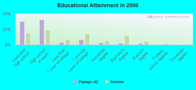
For population 25 years and over in Papago:
- High school or higher: 62.1%
- Bachelor's degree or higher: 5.9%
- Graduate or professional degree: 2.7%
- Unemployed: 25.9%
- Mean travel time to work (commute): 24.8 minutes
| Here: | 13.8 |
| Arizona average: | 13.1 |
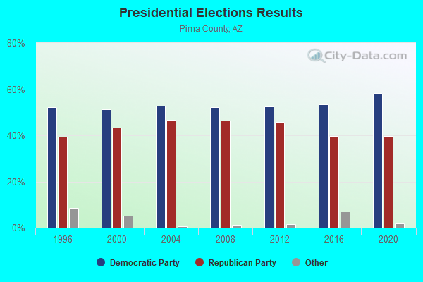
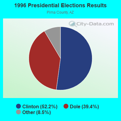
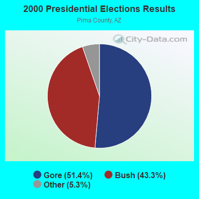
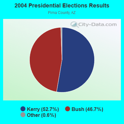
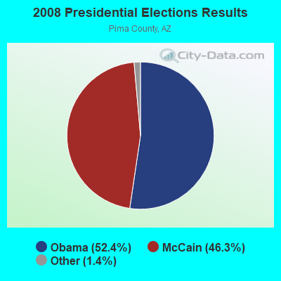

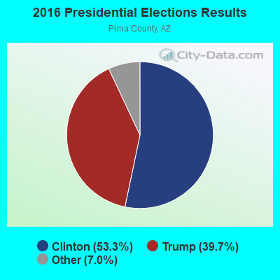
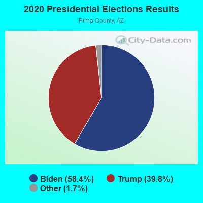
Graphs represent county-level data. Detailed 2008 Election Results
Religion statistics for Papago, AZ (based on Pima County data)
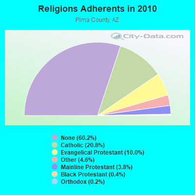
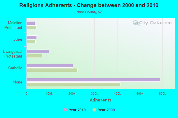
| Religion | Adherents | Congregations |
|---|---|---|
| Catholic | 203,770 | 50 |
| Evangelical Protestant | 98,278 | 362 |
| Other | 45,011 | 128 |
| Mainline Protestant | 37,037 | 77 |
| Black Protestant | 4,190 | 14 |
| Orthodox | 2,260 | 5 |
| None | 589,717 | - |
Food Environment Statistics:
| Pima County: | 1.22 / 10,000 pop. |
| State: | 1.36 / 10,000 pop. |
| Pima County: | 0.09 / 10,000 pop. |
| Arizona: | 0.14 / 10,000 pop. |
| Pima County: | 0.52 / 10,000 pop. |
| Arizona: | 0.55 / 10,000 pop. |
| This county: | 2.27 / 10,000 pop. |
| Arizona: | 2.47 / 10,000 pop. |
| Pima County: | 6.17 / 10,000 pop. |
| Arizona: | 6.21 / 10,000 pop. |
| This county: | 7.8% |
| State: | 8.0% |
| Pima County: | 21.2% |
| Arizona: | 22.8% |
| This county: | 15.2% |
| State: | 14.2% |
5.84% of this county's 2021 resident taxpayers lived in other counties in 2020 ($71,876 average adjusted gross income)
| Here: | 5.84% |
| Arizona average: | 6.85% |
0.07% of residents moved from foreign countries ($644 average AGI)
Pima County: 0.07% Arizona average: 0.03%
Top counties from which taxpayers relocated into this county between 2020 and 2021:
| from Maricopa County, AZ | |
| from Pinal County, AZ | |
| from Cochise County, AZ |
5.17% of this county's 2020 resident taxpayers moved to other counties in 2021 ($65,979 average adjusted gross income)
| Here: | 5.17% |
| Arizona average: | 5.72% |
0.06% of residents moved to foreign countries ($677 average AGI)
Pima County: 0.06% Arizona average: 0.03%
Top counties to which taxpayers relocated from this county between 2020 and 2021:
| to Maricopa County, AZ | |
| to Pinal County, AZ | |
| to Cochise County, AZ |
Strongest AM radio stations in Papago:
- KFLT (830 AM; 50 kW; TUCSON, AZ; Owner: FAMILY LIFE B/CING SYSTEM, INC.)
- KUAZ (1550 AM; daytime; 50 kW; TUCSON, AZ; Owner: ARIZONA BOARD OF REGENTS)
- KPXQ (1360 AM; 50 kW; GLENDALE, AZ; Owner: COMMON GROUND BROADCASTING, INC.)
- KMIA (710 AM; 50 kW; BLACK CANYON CITY, AZ; Owner: ENTRAVISION HOLDINGS, LLC)
- KMIK (1580 AM; 50 kW; TEMPE, AZ; Owner: ABC, INC.)
- KSAZ (580 AM; 5 kW; MARANA, AZ; Owner: OWL BROADCASTING & DEVELOPMENT, INC.)
- KFNX (1100 AM; 50 kW; CAVE CREEK, AZ; Owner: NORTH AMERICAN BROADCASTING CO., INC.)
- KEVT (1030 AM; 10 kW; CORTARO, AZ; Owner: ONE MART CORP.)
- KTKT (990 AM; 10 kW; TUCSON, AZ; Owner: ARIZONA LOTUS CORP.)
- KQTL (1210 AM; 10 kW; SAHUARITA, AZ; Owner: RADIO UNICA OF TUCSON LICENSE CORP.)
- KNST (790 AM; 5 kW; TUCSON, AZ)
- KXEM (1010 AM; 15 kW; TOLLESON, AZ; Owner: JAMES CRYSTAL ENTERPRISES OF PHOENIX, INC.)
- KFNN (1510 AM; 22 kW; MESA, AZ; Owner: CRC BROADCASTING COMPANY, INC.)
Strongest FM radio stations in Papago:
- KXCI (91.3 FM; TUCSON, AZ; Owner: FOUNDATION FOR CREATIVE BROADCASTING, INC.)
- K261CK (100.1 FM; SAN XAVIER, AZ; Owner: WORLD RADIO NETWORK, INC.)
- KZLZ-FM2 (105.3 FM; TUCSON, AZ; Owner: ENTRAVISION HOLDINGS, LLC)
- K263AA (100.5 FM; TUCSON, AZ; Owner: EDUCATIONAL MEDIA FOUNDATION)
- KCDX (103.1 FM; FLORENCE, AZ; Owner: DESERT WEST AIR RANCHERS CORPORATION)
- K255AC (98.9 FM; TUCSON, AZ; Owner: MARICOPA COUNTY COMMUN. COLLEGE DIST)
- KWFM-FM (97.1 FM; GREEN VALLEY, AZ; Owner: CAPSTAR TX LIMITED PARTNERSHIP)
- KUAT-FM (90.5 FM; TUCSON, AZ; Owner: ARIZONA BOARD OF REGENTS)
- K292CM (106.3 FM; SUMMERHAVEN, AZ; Owner: ARIZONA LOTUS CORPORATION)
- KZLZ-FM1 (105.3 FM; TUCSON, AZ; Owner: ENTRAVISION HOLDINGS, LLC)
- KIIM-FM (99.5 FM; TUCSON, AZ; Owner: CITADEL BROADCASTING COMPANY)
- KOYT (92.9 FM; TUCSON, AZ; Owner: CAPSTAR TX LIMITED PARTNERSHIP)
- KHYT (107.5 FM; TUCSON, AZ; Owner: CITADEL BROADCASTING COMPANY)
- KRQQ (93.7 FM; TUCSON, AZ; Owner: CAPSTAR TX LIMITED PARTNERSHIP)
- KMXZ-FM (94.9 FM; TUCSON, AZ; Owner: JOURNAL BROADCAST CORPORATION)
- KLPX (96.1 FM; TUCSON, AZ; Owner: ARIZONA LOTUS CORPORATION)
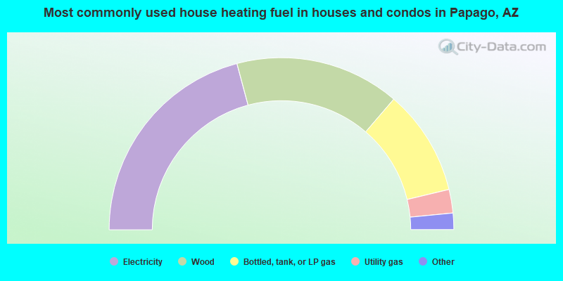
- 41.7%Electricity
- 30.9%Wood
- 19.9%Bottled, tank, or LP gas
- 4.4%Utility gas
- 2.5%No fuel used
- 0.6%Fuel oil, kerosene, etc.
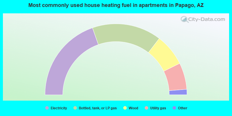
- 39.3%Electricity
- 31.6%Bottled, tank, or LP gas
- 14.6%Wood
- 12.1%Utility gas
- 1.9%No fuel used
- 0.6%Other fuel
Papago compared to Arizona state average:
- Median household income significantly below state average.
- Median house value significantly below state average.
- Unemployed percentage above state average.
- Black race population percentage significantly below state average.
- Hispanic race population percentage significantly below state average.
- Median age significantly below state average.
- Foreign-born population percentage significantly below state average.
- Renting percentage significantly below state average.
- Length of stay since moving in significantly above state average.
- Number of rooms per house significantly below state average.
- House age significantly below state average.
- Institutionalized population percentage significantly above state average.
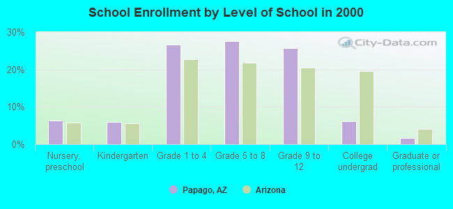
- Number of college students below state average.
- Percentage of population with a bachelor's degree or higher significantly below state average.
Papago on our top lists:
- #1 on the list of "Top 101 cities with largest percentage of males in occupations: child care workers (population 5,000+)"
- #2 on the list of "Top 101 cities with the largest percentage of unmarried partner households (population 5,000+)"
- #2 on the list of "Top 101 cities with largest percentage of males in occupations: bus drivers (population 5,000+)"
- #2 on the list of "Top 101 cities with largest percentage of females in occupations: motor vehicle operators except bus and truck drivers (population 5,000+)"
- #3 on the list of "Top 101 cities with largest percentage of males in industries: social assistance (population 5,000+)"
- #6 on the list of "Top 101 cities with largest percentage of males in occupations: construction laborers (population 5,000+)"
- #6 on the list of "Top 101 cities with largest percentage of males in industries: religious, grantmaking, civic, professional, and similar organizations (population 5,000+)"
- #6 on the list of "Top 101 cities with largest percentage of females in industries: sporting goods, camera, and hobby and toy stores (population 5,000+)"
- #7 on the list of "Top 101 cities with largest percentage of males in occupations: counselors, social workers, and other community and social service specialists (population 5,000+)"
- #8 on the list of "Top 101 cities with largest percentage of females in occupations: other teachers and instructors, education, training, and library occupations (population 5,000+)"
- #10 on the list of "Top 101 cities with largest percentage of males in industries: health care (population 5,000+)"
- #12 on the list of "Top 101 cities with largest percentage of females in industries: public administration (population 5,000+)"
- #16 on the list of "Top 100 cities with largest land areas"
- #29 on the list of "Top 101 cities with largest percentage of females in industries: music stores (population 5,000+)"
- #32 on the list of "Top 101 cities with the largest house values disparities (population 5,000+)"
- #39 on the list of "Top 101 cities with largest percentage of males in industries: warehousing and storage (population 5,000+)"
- #52 on the list of "Top 101 cities with largest percentage of females in industries: religious, grantmaking, civic, professional, and similar organizations (population 5,000+)"
- #60 on the list of "Top 101 cities with largest percentage of females in industries: social assistance (population 5,000+)"
- #72 on the list of "Top 101 cities with the most people carpooling to work (population 5,000+)"
- #76 on the list of "Top 101 cities with largest percentage of males in industries: other transportation, and support activities, and couriers (population 5,000+)"
- #11 on the list of "Top 101 counties with the highest Particulate Matter (PM10) Annual air pollution readings in 2012 (µg/m3)"
- #14 on the list of "Top 101 counties with the highest ground withdrawal of fresh water for public supply"
- #29 on the list of "Top 101 counties with the highest carbon monoxide air pollution readings in 2012 (ppm)"
- #35 on the list of "Top 101 counties with the most Other congregations"
- #45 on the list of "Top 101 counties with the highest total withdrawal of fresh water for public supply (pop. 50,000+)"