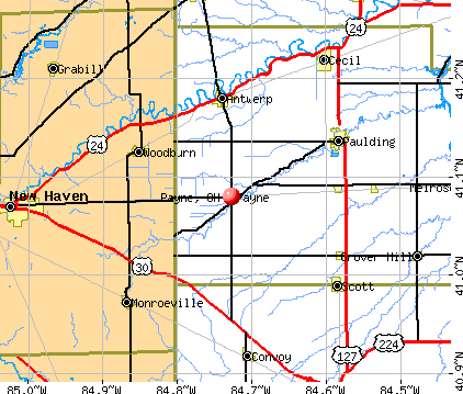
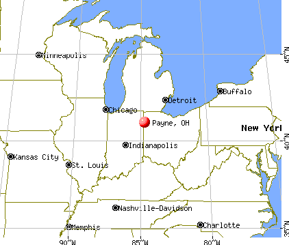
Payne, Ohio

Submit your own pictures of this village and show them to the world
- OSM Map
- General Map
- Google Map
- MSN Map
Population change since 2000: +1.5%
 |
| Males: 561 | |
| Females: 622 |
| Median resident age: | 30.3 years |
| Ohio median age: | 39.9 years |
Zip codes: 45880.
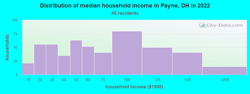
| Payne: | $54,151 |
| OH: | $65,720 |
Estimated per capita income in 2022: $23,748 (it was $17,908 in 2000)
Payne village income, earnings, and wages data
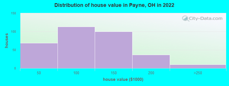
Estimated median house or condo value in 2022: $107,562 (it was $61,300 in 2000)
| Payne: | $107,562 |
| OH: | $204,100 |
Mean prices in 2022: all housing units: $109,162; detached houses: $115,284; mobile homes: $54,049
Median gross rent in 2022: $810.
(19.5% for White Non-Hispanic residents, 14.8% for two or more races residents)
Detailed information about poverty and poor residents in Payne, OH
Compare current foreclosures near Payne, OH:
| Photo | Address | Area | Beds / Baths | Price | Details |
|---|---|---|---|---|---|

|
#1
S Taylor St
Sherwood, OH 43556
|
956 sq. feet
|
1 baths 2 beds |
$33,900
|
show details |

|
#2
E Smith St
Hicksville, OH 43526
|
1,540 sq. feet
|
2 baths 4 beds |
show details | |

|
#3
Hawk Rdg
Harlan, IN 46743
|
- sq. feet
|
2 baths 3 beds |
show details | |

|
#4
E High St
Hicksville, OH 43526
|
1,556 sq. feet
|
2 baths 3 beds |
show details | |

|
#5
Farmer Mark Rd
Mark Center, OH 43536
|
936 sq. feet
|
1 baths 3 beds |
show details | |

|
#6
S Vine St
Van Wert, OH 45891
|
1,204 sq. feet
|
2 baths 2 beds |
show details | |

|
#7
746 Shannon St
Van Wert, OH 45891
|
1,184 sq. feet
|
1 baths 2 beds |
show details | |

|
#8
Road 87
Paulding, OH 45879
|
1,180 sq. feet
|
1 baths 3 beds |
show details | |

|
#9
Jonathon Pl
New Haven, IN 46774
|
1,909 sq. feet
|
2 baths 4 beds |
show details | |

|
#10
Repton Dr
Fort Wayne, IN 46815
|
1,188 sq. feet
|
1 baths 3 beds |
show details |
| Photo | Address | Area | Beds / Baths | Price | Details |
|---|---|---|---|---|---|

|
#11
Woodmere Dr
New Haven, IN 46774
|
1,352 sq. feet
|
1 baths 3 beds |
show details | |

|
#12
Hollendale Dr
New Haven, IN 46774
|
1,624 sq. feet
|
1 baths 3 beds |
show details | |

|
#13
Maysville Rd
Fort Wayne, IN 46835
|
1,656 sq. feet
|
1 baths 3 beds |
show details | |

|
#14
Whitfield Chase
Fort Wayne, IN 46815
|
2,222 sq. feet
|
2 baths 3 beds |
show details | |

|
#15
Maple Dr
Grabill, IN 46741
|
1,626 sq. feet
|
2 baths 4 beds |
show details | |

|
#16
Repton Dr
Fort Wayne, IN 46815
|
1,262 sq. feet
|
1 baths 3 beds |
show details | |

|
#17
Pinestone Dr
New Haven, IN 46774
|
1,917 sq. feet
|
2 baths 3 beds |
show details | |

|
#18
Sunview Dr
Woodburn, IN 46797
|
1,424 sq. feet
|
1 baths 3 beds |
show details | |

|
#19
Shawnee Trl
New Haven, IN 46774
|
1,715 sq. feet
|
2 baths 3 beds |
show details | |

|
#20
Park State Dr
Fort Wayne, IN 46815
|
2,284 sq. feet
|
2 baths 3 beds |
show details |
| Photo | Address | Area | Beds / Baths | Price | Details |
|---|---|---|---|---|---|

|
#21
N Jefferson St
Van Wert, OH 45891
|
2,716 sq. feet
|
2 baths 3 beds |
show details | |

|
#22
Tiger Lily Pl
Fort Wayne, IN 46835
|
1,724 sq. feet
|
2 baths 3 beds |
show details | |

|
#23
Wheelock Rd
Fort Wayne, IN 46835
|
1,950 sq. feet
|
2 baths 3 beds |
show details | |

|
#24
Chivington Dr
Fort Wayne, IN 46815
|
1,398 sq. feet
|
2 baths 3 beds |
show details | |

|
#25
Bellwood Dr
Fort Wayne, IN 46815
|
1,900 sq. feet
|
2 baths 3 beds |
show details | |

|
#26
Albany Ct
Fort Wayne, IN 46835
|
2,976 sq. feet
|
2 baths 4 beds |
show details | |

|
#27
Imperial Park Dr
Fort Wayne, IN 46835
|
1,462 sq. feet
|
2 baths 3 beds |
show details | |

|
#28
Antebellum Dr
Fort Wayne, IN 46815
|
1,712 sq. feet
|
2 baths 3 beds |
show details | |

|
#29
English St
Hoagland, IN 46745
|
2,474 sq. feet
|
1 baths 4 beds |
show details | |

|
#30
Courtney Dr
New Haven, IN 46774
|
900 sq. feet
|
1 baths 3 beds |
show details |
| Photo | Address | Area | Beds / Baths | Price | Details |
|---|---|---|---|---|---|

|
#31
Chiswell Run
Fort Wayne, IN 46835
|
2,308 sq. feet
|
3 baths 3 beds |
show details | |

|
#32
High St
Van Wert, OH 45891
|
1,212 sq. feet
|
2 baths 3 beds |
show details | |

|
#33
Talmage Ct
Fort Wayne, IN 46835
|
1,564 sq. feet
|
2 baths 3 beds |
show details | |

|
#34
Belton Ln
Fort Wayne, IN 46815
|
2,696 sq. feet
|
3 baths 5 beds |
show details | |

|
#35
W Main St
Van Wert, OH 45891
|
1,501 sq. feet
|
1 baths 3 beds |
show details | |

|
#36
Kildare Xing
Fort Wayne, IN 46835
|
1,952 sq. feet
|
2 baths 4 beds |
show details | |

|
#37
S Country Knl
New Haven, IN 46774
|
1,184 sq. feet
|
1 baths 3 beds |
show details | |

|
#38
Hartzell St
New Haven, IN 46774
|
1,320 sq. feet
|
2 baths 3 beds |
show details | |

|
#39
Cherokee Run
New Haven, IN 46774
|
2,986 sq. feet
|
2 baths 4 beds |
show details | |

|
#40
Roberts Rd
Harlan, IN 46743
|
1,364 sq. feet
|
1 baths 2 beds |
show details |
| Photo | Address | Area | Beds / Baths | Price | Details |
|---|---|---|---|---|---|

|
#41
W Wayne St
Paulding, OH 45879
|
945 sq. feet
|
1 baths 2 beds |
show details | |

|
#42
N Webster Rd
New Haven, IN 46774
|
1,634 sq. feet
|
2 baths 4 beds |
show details | |

|
#43
Canal St
New Haven, IN 46774
|
1,055 sq. feet
|
1 baths 2 beds |
show details | |

|
#44
Springfield Center Rd
Grabill, IN 46741
|
1,248 sq. feet
|
1 baths 3 beds |
show details | |

|
#45
Wolfcale Rd
Van Wert, OH 45891
|
2,135 sq. feet
|
1 baths 3 beds |
show details | |

|
#46
E First St
Grover Hill, OH 45849
|
17 sq. feet
|
1 baths 3 beds |
show details | |

|
#47
Darby Ln
New Haven, IN 46774
|
1,012 sq. feet
|
1 baths 3 beds |
show details | |

|
#48
Keller Dr
New Haven, IN 46774
|
1,194 sq. feet
|
1 baths 2 beds |
show details | |

|
#49
Macpherson Dr
New Haven, IN 46774
|
1,800 sq. feet
|
2 baths 5 beds |
show details | |

|
Check over 1 million property listings on Foreclosure.com!
|
browse all offers | |||


- 1,32190.8%White alone
- 604.1%Two or more races
- 412.8%Hispanic
- 171.2%Black alone
- 70.5%Asian alone
- 20.1%American Indian alone
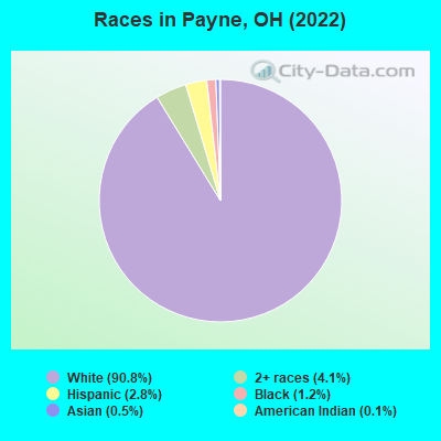
Races in Payne detailed stats: ancestries, foreign born residents, place of birth
According to our research of Ohio and other state lists, there were 2 registered sex offenders living in Payne, Ohio as of May 14, 2024.
The ratio of all residents to sex offenders in Payne is 585 to 1.
The ratio of registered sex offenders to all residents in this city is near the state average.
Type |
2009 |
2010 |
2011 |
2012 |
2013 |
2014 |
2015 |
2016 |
2017 |
2018 |
2019 |
2020 |
2022 |
|---|---|---|---|---|---|---|---|---|---|---|---|---|---|
| Murders (per 100,000) | 0 (0.0) | 0 (0.0) | 0 (0.0) | 0 (0.0) | 0 (0.0) | 0 (0.0) | 0 (0.0) | 0 (0.0) | 0 (0.0) | 0 (0.0) | 0 (0.0) | 0 (0.0) | 0 (0.0) |
| Rapes (per 100,000) | 0 (0.0) | 1 (83.8) | 0 (0.0) | 0 (0.0) | 1 (85.4) | 0 (0.0) | 0 (0.0) | 0 (0.0) | 1 (87.2) | 0 (0.0) | 0 (0.0) | 0 (0.0) | 0 (0.0) |
| Robberies (per 100,000) | 0 (0.0) | 0 (0.0) | 0 (0.0) | 0 (0.0) | 0 (0.0) | 0 (0.0) | 0 (0.0) | 0 (0.0) | 0 (0.0) | 0 (0.0) | 0 (0.0) | 0 (0.0) | 0 (0.0) |
| Assaults (per 100,000) | 1 (87.3) | 0 (0.0) | 0 (0.0) | 0 (0.0) | 0 (0.0) | 1 (85.7) | 0 (0.0) | 0 (0.0) | 0 (0.0) | 0 (0.0) | 1 (88.0) | 0 (0.0) | 0 (0.0) |
| Burglaries (per 100,000) | 8 (698.7) | 5 (418.8) | 5 (418.4) | 7 (592.7) | 4 (341.6) | 0 (0.0) | 2 (174.2) | 0 (0.0) | 2 (174.4) | 0 (0.0) | 2 (175.9) | 0 (0.0) | 0 (0.0) |
| Thefts (per 100,000) | 4 (349.3) | 10 (837.5) | 6 (502.1) | 10 (846.7) | 1 (85.4) | 4 (342.8) | 4 (348.4) | 3 (261.3) | 6 (523.1) | 3 (262.9) | 5 (439.8) | 3 (264.8) | 14 (1,186) |
| Auto thefts (per 100,000) | 1 (87.3) | 0 (0.0) | 0 (0.0) | 0 (0.0) | 0 (0.0) | 0 (0.0) | 0 (0.0) | 1 (87.1) | 0 (0.0) | 0 (0.0) | 0 (0.0) | 0 (0.0) | 0 (0.0) |
| Arson (per 100,000) | 0 (0.0) | 0 (0.0) | 0 (0.0) | 0 (0.0) | 0 (0.0) | 0 (0.0) | 0 (0.0) | 0 (0.0) | 0 (0.0) | 0 (0.0) | 0 (0.0) | 0 (0.0) | 0 (0.0) |
| City-Data.com crime index | 87.3 | 129.8 | 49.4 | 75.4 | 95.6 | 30.8 | 26.1 | 17.4 | 102.9 | 10.5 | 47.5 | 10.6 | 47.5 |
The City-Data.com crime index weighs serious crimes and violent crimes more heavily. Higher means more crime, U.S. average is 246.1. It adjusts for the number of visitors and daily workers commuting into cities.
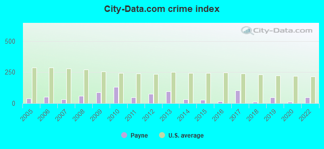
Crime rate in Payne detailed stats: murders, rapes, robberies, assaults, burglaries, thefts, arson
Full-time law enforcement employees in 2011, including police officers: 1 (1 officers - 1 male; 0 female).
| Officers per 1,000 residents here: | 0.84 |
| Ohio average: | 2.11 |
 Recent articles from our blog. Our writers, many of them Ph.D. graduates or candidates, create easy-to-read articles on a wide variety of topics.

 | RTA: What's good, bad, and improvable (424 replies) |
| Cleveland Development Discussions (4356 replies) |
| What Are the Things That Clevelanders Take for Granted? (154 replies) |
| Cleveland art deco buildings (3 replies) |
| Why is Ohio cheap? (132 replies) |
| Ohio State basketball in the dumps (43 replies) |
Latest news from Payne, OH collected exclusively by city-data.com from local newspapers, TV, and radio stations
Ancestries: German (36.8%), Irish (19.5%), European (6.5%), American (5.9%), English (4.6%), Italian (3.6%).
Current Local Time: EST time zone
Elevation: 753 feet
Land area: 0.54 square miles.
Population density: 2,200 people per square mile (low).
7 residents are foreign born
| This village: | 0.5% |
| Ohio: | 4.9% |
Median real estate property taxes paid for housing units with mortgages in 2022: $1,324 (1.1%)
Median real estate property taxes paid for housing units with no mortgage in 2022: $1,104 (1.2%)
Nearest city with pop. 50,000+: Fort Wayne, IN  (20.8 miles , pop. 205,727).
Nearest city with pop. 1,000,000+: Chicago, IL (161.8 miles , pop. 2,896,016).
Nearest cities:
), Latitude: 41.08 N, Longitude: 84.73 W
Area codes: 419, 567

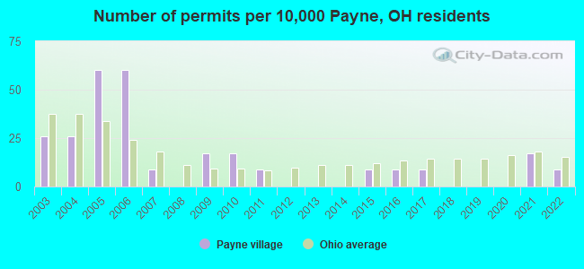
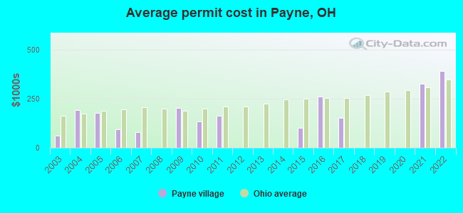
Single-family new house construction building permits:
- 2022: 1 building, cost: $390,000
- 2021: 2 buildings, average cost: $326,300
- 2017: 1 building, cost: $151,900
- 2016: 1 building, cost: $261,300
- 2015: 1 building, cost: $100,200
- 2011: 1 building, cost: $163,000
- 2010: 2 buildings, average cost: $132,500
- 2009: 2 buildings, average cost: $201,500
- 2007: 1 building, cost: $80,000
- 2006: 7 buildings, average cost: $93,100
- 2005: 7 buildings, average cost: $177,300
- 2004: 3 buildings, average cost: $192,000
- 2003: 3 buildings, average cost: $60,700
| Here: | 2.6% |
| Ohio: | 3.1% |
- Health care (11.9%)
- Plastics & rubber products (9.8%)
- Nonmetallic mineral products (7.3%)
- Metal & metal products (7.0%)
- Educational services (5.9%)
- Transportation equipment (5.2%)
- Truck transportation (5.1%)
- Nonmetallic mineral products (11.9%)
- Plastics & rubber products (11.3%)
- Truck transportation (9.9%)
- Metal & metal products (7.8%)
- Transportation equipment (6.8%)
- Construction (4.8%)
- Health care (4.1%)
- Health care (20.0%)
- Plastics & rubber products (8.2%)
- Educational services (8.2%)
- Finance & insurance (6.1%)
- Metal & metal products (6.1%)
- Food & beverage stores (3.9%)
- Accommodation & food services (3.9%)
- Other production occupations, including supervisors (11.5%)
- Metal workers and plastic workers (6.3%)
- Driver/sales workers and truck drivers (6.1%)
- Laborers and material movers, hand (4.9%)
- Building and grounds cleaning and maintenance occupations (3.8%)
- Other sales and related occupations, including supervisors (3.7%)
- Other office and administrative support workers, including supervisors (3.7%)
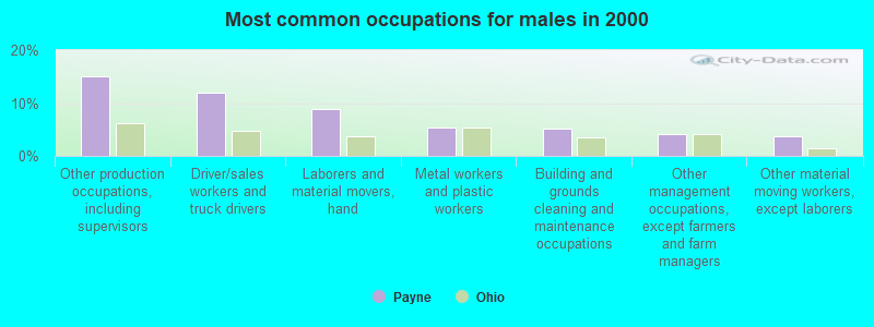
- Other production occupations, including supervisors (15.0%)
- Driver/sales workers and truck drivers (11.9%)
- Laborers and material movers, hand (8.9%)
- Metal workers and plastic workers (5.5%)
- Building and grounds cleaning and maintenance occupations (5.1%)
- Other management occupations, except farmers and farm managers (4.1%)
- Other material moving workers, except laborers (3.8%)

- Other production occupations, including supervisors (7.9%)
- Metal workers and plastic workers (7.1%)
- Other office and administrative support workers, including supervisors (6.1%)
- Nursing, psychiatric, and home health aides (5.7%)
- Other sales and related occupations, including supervisors (4.6%)
- Cashiers (4.6%)
- Information and record clerks, except customer service representatives (3.9%)
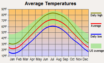
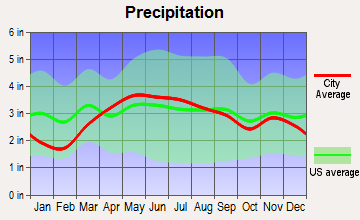
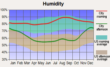
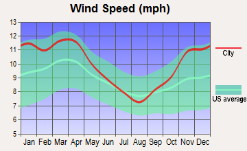
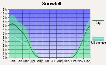
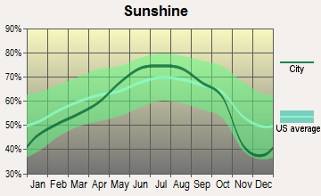
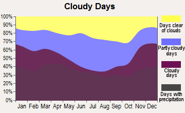
Average climate in Payne, Ohio
Based on data reported by over 4,000 weather stations
|
|


(lower is better)
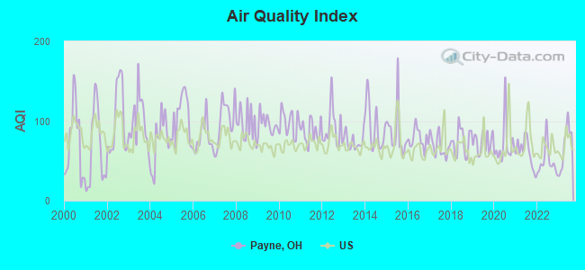
Air Quality Index (AQI) level in 2023 was 69.2. This is about average.
| City: | 69.2 |
| U.S.: | 72.6 |
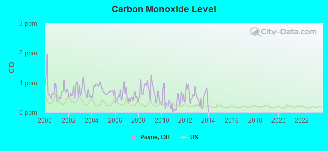
Carbon Monoxide (CO) [ppm] level in 2013 was 0.447. This is significantly worse than average. Closest monitor was 21.4 miles away from the city center.
| City: | 0.447 |
| U.S.: | 0.251 |
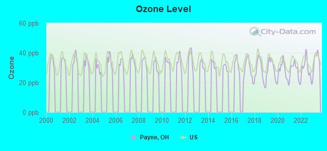
Ozone [ppb] level in 2023 was 34.9. This is about average. Closest monitor was 18.0 miles away from the city center.
| City: | 34.9 |
| U.S.: | 33.3 |
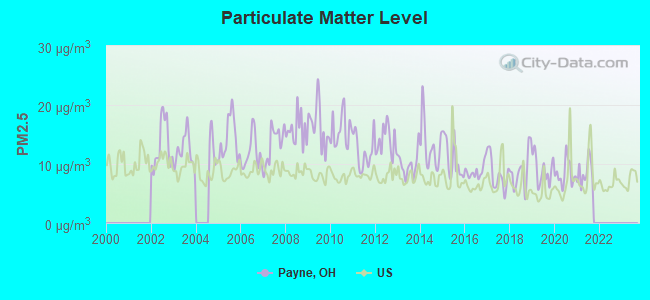
Particulate Matter (PM2.5) [µg/m3] level in 2021 was 8.61. This is about average. Closest monitor was 19.6 miles away from the city center.
| City: | 8.61 |
| U.S.: | 8.11 |
Tornado activity:
Payne-area historical tornado activity is slightly above Ohio state average. It is 62% greater than the overall U.S. average.
On 11/10/2002, a category F4 (max. wind speeds 207-260 mph) tornado 20.8 miles away from the Payne village center killed 4 people and injured 17 people and caused $30 million in damages.
On 2/18/1992, a category F4 tornado 25.5 miles away from the village center injured 6 people and caused between $500,000 and $5,000,000 in damages.
Earthquake activity:
Payne-area historical earthquake activity is significantly above Ohio state average. It is 6% smaller than the overall U.S. average.On 7/12/1986 at 08:19:37, a magnitude 4.5 (4.5 MB, Class: Light, Intensity: IV - V) earthquake occurred 41.9 miles away from the city center
On 7/27/1980 at 18:52:21, a magnitude 5.2 (5.1 MB, 4.7 MS, 5.0 UK, 5.2 UK, Class: Moderate, Intensity: VI - VII) earthquake occurred 203.2 miles away from the city center
On 4/18/2008 at 09:36:59, a magnitude 5.4 (5.1 MB, 4.8 MS, 5.4 MW, 5.2 MW) earthquake occurred 247.4 miles away from the city center
On 9/25/1998 at 19:52:52, a magnitude 5.2 (4.8 MB, 4.3 MS, 5.2 LG, 4.5 MW, Depth: 3.1 mi) earthquake occurred 226.9 miles away from Payne center
On 1/31/1986 at 16:46:43, a magnitude 5.0 (5.0 MB) earthquake occurred 188.7 miles away from Payne center
On 4/18/2008 at 09:36:59, a magnitude 5.2 (5.2 MW, Depth: 8.9 mi) earthquake occurred 247.4 miles away from the city center
Magnitude types: regional Lg-wave magnitude (LG), body-wave magnitude (MB), surface-wave magnitude (MS), moment magnitude (MW)
Natural disasters:
The number of natural disasters in Paulding County (10) is smaller than the US average (15).Major Disasters (Presidential) Declared: 6
Emergencies Declared: 3
Causes of natural disasters: Floods: 3, Storms: 3, Snowstorms: 2, Tornadoes: 2, Blizzard: 1, Hurricane: 1, Mudslide: 1, Wind: 1, Winter Storm: 1, Other: 1 (Note: some incidents may be assigned to more than one category).

Hospitals and medical centers in Payne:
Other hospitals and medical centers near Payne:
- PAULDING COUNTY HOSPITAL Critical Access Hospitals (about 8 miles away; PAULDING, OH)
- PAULDING COUNTY HOSPITAL HOME HEALTH (Home Health Center, about 10 miles away; PAULDING, OH)
- VILLAGE OF HERITAGE THE (Nursing Home, about 11 miles away; MONROEVILLE, IN)
- VANCREST OF CONVOY (Nursing Home, about 12 miles away; CONVOY, OH)
- FMC - CANAL DIALYSIS (Dialysis Facility, about 15 miles away; NEW HAVEN, IN)
- HICKORY CREEK AT HICKSVILLE (Nursing Home, about 15 miles away; HICKSVILLE, OH)
- NEW HORIZONS HOME HEALTH SERVICES (Home Health Center, about 16 miles away; NEW HAVEN, IN)
Colleges/universities with over 2000 students nearest to Payne:
- Indiana University-Purdue University-Fort Wayne (about 21 miles; Fort Wayne, IN; Full-time enrollment: 10,126)
- Indiana Institute of Technology (about 21 miles; Fort Wayne, IN; FT enrollment: 4,320)
- University of Saint Francis-Fort Wayne (about 24 miles; Fort Wayne, IN; FT enrollment: 2,075)
- Northwest State Community College (about 34 miles; Archbold, OH; FT enrollment: 2,406)
- University of Northwestern Ohio (about 38 miles; Lima, OH; FT enrollment: 4,231)
- James A Rhodes State College (about 44 miles; Lima, OH; FT enrollment: 2,689)
- Ohio Northern University (about 52 miles; Ada, OH; FT enrollment: 2,474)
Public elementary/middle school in Payne:
- PAYNE ELEMENTARY SCHOOL (Students: 275, Location: 501 W TOWNLINE ST, Grades: KG-6)
Private elementary/middle school in Payne:
Points of interest:
Notable location: Payne Volunteer Fire and Emergency Medical Services Department (A). Display/hide its location on the map
Churches in Payne include: Payne Church of Christ (A), Saint James Lutheran Church (B), Saint Paul United Methodist Church (C), Saint John the Baptist Roman Catholic Church (D), Saint Jacobs Evangelical and Reformed Church (E), Church of God (F). Display/hide their locations on the map
Parks in Payne include: Payne Community Park (1), School Park (2). Display/hide their locations on the map
Drinking water stations with addresses in Payne that have no violations reported:
- PLEASANT VALLEY GOLF COURSE (Population served: 145, Primary Water Source Type: Groundwater)
| This village: | 2.4 people |
| Ohio: | 2.4 people |
| This village: | 64.4% |
| Whole state: | 65.0% |
| This village: | 7.4% |
| Whole state: | 6.8% |
No gay or lesbian households reported
2 people in religious group quarters in 2000
Banks with branches in Payne (2011 data):
- The Antwerp Exchange Bank Company: Payne Branch at 119 North Main Street, branch established on 2008/12/15. Info updated 2012/01/04: Bank assets: $81.7 mil, Deposits: $70.1 mil, headquarters in Antwerp, OH, positive income, Agricultural Specialization, 2 total offices, Holding Company: Diamond Bancshares, Inc.
For population 15 years and over in Payne:
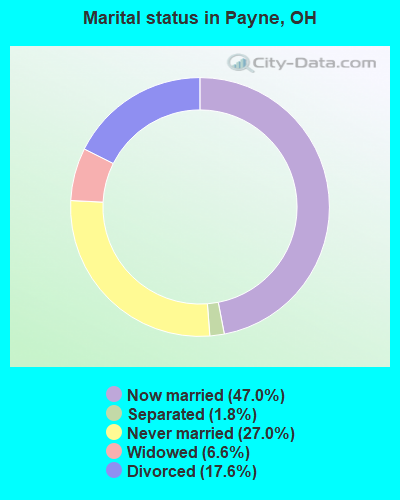
- Never married: 27.0%
- Now married: 47.0%
- Separated: 1.8%
- Widowed: 6.6%
- Divorced: 17.6%
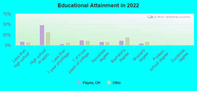
For population 25 years and over in Payne:
- High school or higher: 89.2%
- Bachelor's degree or higher: 15.4%
- Graduate or professional degree: 4.7%
- Unemployed: 5.0%
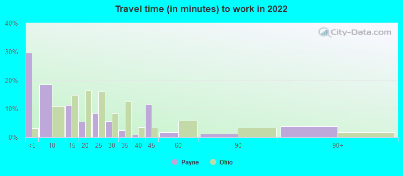
- Mean travel time to work (commute): 24.4 minutes
| Here: | 8.9 |
| Ohio average: | 11.0 |
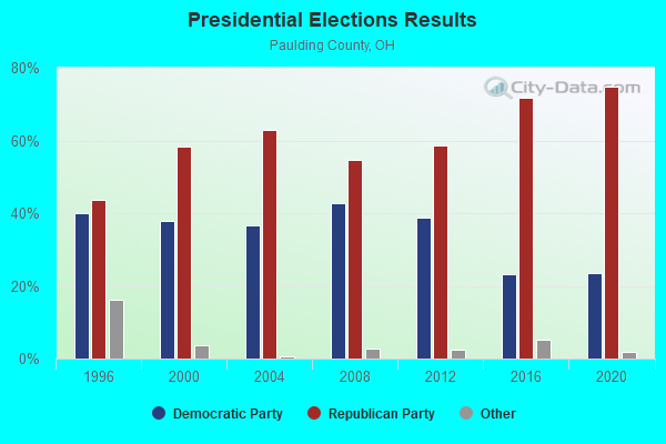
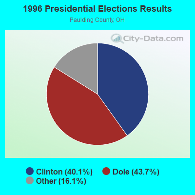
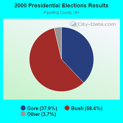
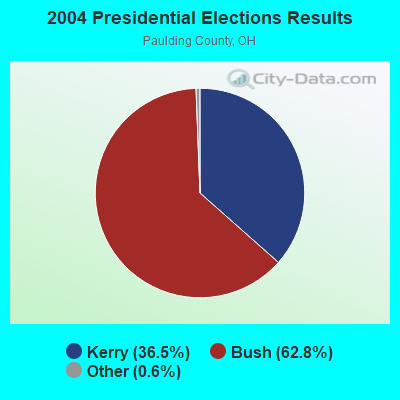
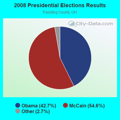
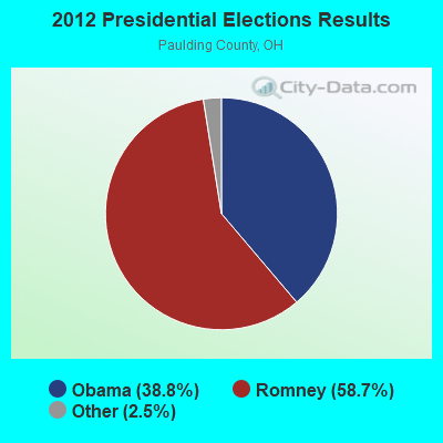
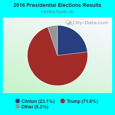
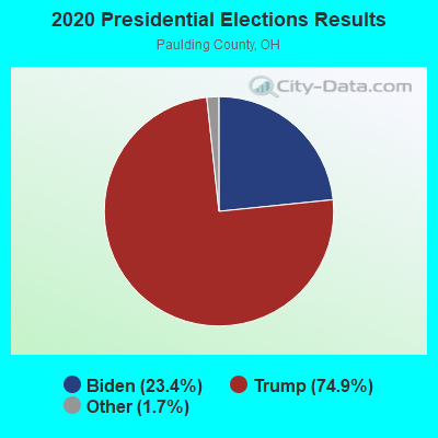
Graphs represent county-level data. Detailed 2008 Election Results
Religion statistics for Payne, OH (based on Paulding County data)
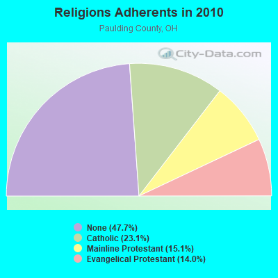

| Religion | Adherents | Congregations |
|---|---|---|
| Catholic | 4,532 | 4 |
| Mainline Protestant | 2,967 | 17 |
| Evangelical Protestant | 2,749 | 21 |
| Other | 2 | 1 |
| None | 9,364 | - |
Food Environment Statistics:
| Paulding County: | 2.61 / 10,000 pop. |
| Ohio: | 1.89 / 10,000 pop. |
| Paulding County: | 0.52 / 10,000 pop. |
| State: | 1.25 / 10,000 pop. |
| This county: | 4.69 / 10,000 pop. |
| State: | 2.93 / 10,000 pop. |
| This county: | 6.78 / 10,000 pop. |
| State: | 6.25 / 10,000 pop. |
| This county: | 10.3% |
| Ohio: | 10.3% |
| This county: | 29.7% |
| State: | 29.1% |
| This county: | 6.9% |
| State: | 11.9% |
Health and Nutrition:
| This city: | 56.9% |
| Ohio: | 50.4% |
| Payne: | 56.8% |
| State: | 47.8% |
| Payne: | 27.7 |
| Ohio: | 28.7 |
| Payne: | 18.7% |
| Ohio: | 20.6% |
| This city: | 8.1% |
| Ohio: | 10.4% |
| Payne: | 7.1 |
| Ohio: | 6.8 |
| Here: | 31.9% |
| Ohio: | 34.3% |
| Payne: | 63.9% |
| Ohio: | 57.0% |
| Here: | 80.4% |
| State: | 79.1% |
More about Health and Nutrition of Payne, OH Residents
| Local government employment and payroll (March 2022) | |||||
| Function | Full-time employees | Monthly full-time payroll | Average yearly full-time wage | Part-time employees | Monthly part-time payroll |
|---|---|---|---|---|---|
| Police Protection - Officers | 2 | $7,704 | $46,224 | 0 | $0 |
| Water Supply | 1 | $7,134 | $85,608 | 1 | $465 |
| Firefighters | 0 | $0 | 22 | $691 | |
| Financial Administration | 0 | $0 | 2 | $3,395 | |
| Streets and Highways | 0 | $0 | 1 | $1,206 | |
| Judicial and Legal | 0 | $0 | 1 | $35 | |
| Other Government Administration | 0 | $0 | 11 | $11,514 | |
| Totals for Government | 3 | $14,838 | $59,352 | 38 | $17,306 |
Payne government finances - Expenditure in 2017 (per resident):
- Current Operations - Water Utilities: $127,000 ($107.35)
Police Protection: $87,000 ($73.54)
Sewerage: $79,000 ($66.78)
Regular Highways: $78,000 ($65.93)
Central Staff Services: $72,000 ($60.86)
Local Fire Protection: $65,000 ($54.95)
Solid Waste Management: $59,000 ($49.87)
Financial Administration: $43,000 ($36.35)
Health - Other: $35,000 ($29.59)
General - Other: $34,000 ($28.74)
Parks and Recreation: $5,000 ($4.23)
- General - Interest on Debt: $15,000 ($12.68)
- Other Capital Outlay - Health - Other: $32,000 ($27.05)
Sewerage: $25,000 ($21.13)
Regular Highways: $13,000 ($10.99)
Police Protection: $8,000 ($6.76)
Water Utilities: $5,000 ($4.23)
Central Staff Services: $2,000 ($1.69)
- Total Salaries and Wages: $213,000 ($180.05)
Payne government finances - Revenue in 2017 (per resident):
- Charges - Sewerage: $124,000 ($104.82)
Solid Waste Management: $60,000 ($50.72)
Other: $33,000 ($27.90)
- Local Intergovernmental - Public Welfare: $65,000 ($54.95)
Highways: $51,000 ($43.11)
General Local Government Support: $35,000 ($29.59)
- Miscellaneous - General Revenue - Other: $31,000 ($26.20)
Fines and Forfeits: $12,000 ($10.14)
Rents: $8,000 ($6.76)
Sale of Property: $6,000 ($5.07)
Donations From Private Sources: $4,000 ($3.38)
Interest Earnings: $1,000 ($0.85)
- Revenue - Water Utilities: $192,000 ($162.30)
- State Intergovernmental - Public Welfare: $26,000 ($21.98)
- Tax - Property: $196,000 ($165.68)
Motor Vehicle License: $6,000 ($5.07)
Occupation and Business License - Other: $1,000 ($0.85)
Alcoholic Beverage License: $1,000 ($0.85)
Payne government finances - Debt in 2017 (per resident):
- Long Term Debt - Beginning Outstanding - Unspecified Public Purpose: $367,000 ($310.23)
Outstanding Unspecified Public Purpose: $322,000 ($272.19)
Retired Unspecified Public Purpose: $45,000 ($38.04)
Payne government finances - Cash and Securities in 2017 (per resident):
- Other Funds - Cash and Securities: $712,000 ($601.86)
Strongest AM radio stations in Payne:
- WOWO (1190 AM; 50 kW; FORT WAYNE, IN; Owner: PATHFINDER COMMUNICATIONS CORPORATION)
- WONO (1380 AM; 5 kW; FORT WAYNE, IN; Owner: PATHFINDER COMMUNICATIONS CORPORATION)
- WFCV (1090 AM; daytime; 2 kW; FORT WAYNE, IN; Owner: BOTT BROADCASTING COMPANY)
- WFDF (910 AM; 50 kW; FLINT, MI; Owner: ABC, INC.)
- WJR (760 AM; 50 kW; DETROIT, MI; Owner: ABC, INC.)
- WLW (700 AM; 50 kW; CINCINNATI, OH; Owner: JACOR BROADCASTING CORPORATION)
- WDFN (1130 AM; 50 kW; DETROIT, MI; Owner: AMFM RADIO LICENSES, L.L.C.)
- WCHB (1200 AM; 50 kW; TAYLOR, MI; Owner: RADIO ONE OF DETROIT, LLC)
- WTVN (610 AM; 50 kW; COLUMBUS, OH; Owner: CITICASTERS LICENSES, L.P.)
- WGL (1250 AM; 2 kW; FORT WAYNE, IN; Owner: TRAVIS BROADCASTING, LLC)
- WIBC (1070 AM; 50 kW; INDIANAPOLIS, IN; Owner: EMMIS RADIO LICENSE CORPORATION)
- WWJ (950 AM; 50 kW; DETROIT, MI; Owner: INFINITY BROADCASTING OPERATIONS, INC.)
- WXYT (1270 AM; 50 kW; DETROIT, MI; Owner: INFINITY BROADCASTING CORP. OF DETROIT)
Strongest FM radio stations in Payne:
- WKSD (99.7 FM; PAULDING, OH; Owner: FIRST FAMILY BROADCASTING, INC.)
- WBYR (98.9 FM; VAN WERT, OH; Owner: PATHFINDER COMMUNICATIONS CORPORATION)
- WJFX (107.9 FM; NEW HAVEN, IN; Owner: FORT WAYNE RADIO CORP.)
- WQHK-FM (105.1 FM; DECATUR, IN; Owner: JAM COMMUNICATIONS, INC.)
- WFJZ (106.7 FM; HICKSVILLE, OH; Owner: FALLEN TIMBER COMMUNICATIONS, LLC)
- WDFM (98.1 FM; DEFIANCE, OH; Owner: CITICASTERS LICENSES, L.P.)
- WLAB (88.3 FM; FORT WAYNE, IN; Owner: INDIANA DISTTRICT OF THE LUTHERAN CHURCH - MO SYNOD, INC.)
- WAJI (95.1 FM; FORT WAYNE, IN; Owner: SARKES TARZIAN, INC.)
- WBCL (90.3 FM; FORT WAYNE, IN; Owner: TAYLOR UNIVERSITY BROADCASTING, INC.)
- WMEE (97.3 FM; FORT WAYNE, IN; Owner: PATHFINDER COMMUNICATIONS CORPORATION)
- WBNI-FM (89.1 FM; FORT WAYNE, IN; Owner: PUBLIC BROADCASTING OF NE IN., INC.)
- WNHT (96.3 FM; CHURUBUSCO, IN; Owner: TRAVIS BROADCASTING, LLC)
- WIMT (102.1 FM; LIMA, OH; Owner: JACOR BROADCASTING CORPORATION)
- WFWI (92.3 FM; FORT WAYNE, IN; Owner: PATHFINDER COMMUNICATIONS CORPORATION)
- WLDE (101.7 FM; FORT WAYNE, IN; Owner: SARKES TARZIAN, INC.)
- WMLX (103.3 FM; ST. MARYS, OH; Owner: JACOR BROADCASTING CORPORATION)
- WZOM (105.7 FM; DEFIANCE, OH; Owner: CLEAR CHANNEL BROADCASTING LICENSES, INC.)
- WYLT (103.9 FM; FORT WAYNE, IN; Owner: TAVIS BROADCASTING, LLC)
- WBCJ (88.1 FM; SPENCERVILLE, OH; Owner: TAYLOR UNIVERSITY BROADCASTING, INC)
- WGDE (91.9 FM; DEFIANCE, OH; Owner: PUB. BR/CAST. FOUNDATION OF NW OHIO)
TV broadcast stations around Payne:
- WDFM-LP (Channel 19; DEFIANCE, OH; Owner: CITICASTERS LICENSES, L.P.)
- WANE-TV (Channel 15; FORT WAYNE, IN; Owner: INDIANA BROADCASTING, LLC)
- WFFT-TV (Channel 55; FORT WAYNE, IN; Owner: QUOROM OF FT. WAYNE LICENSE, LLC)
- WPTA (Channel 21; FORT WAYNE, IN; Owner: WPTA-TV LICENSE, INC.)
- WISE-TV (Channel 33; FORT WAYNE, IN; Owner: NVG-FORT WAYNE II, LLC)
- WFWA (Channel 39; FORT WAYNE, IN; Owner: FORT WAYNE PUBLIC TELEVISION, INC.)
- W66BD (Channel 53; FORT WAYNE, IN; Owner: TRI-STATE CHRISTIAN TELEVISION)
- W45AG (Channel 45; FORT WAYNE, IN; Owner: TRAN STAR, INC.)
- WBGU-TV (Channel 27; BOWLING GREEN, OH; Owner: BOWLING GREEN STATE UNIVERSITY)
- WLMO-LP (Channel 65; LIMA, OH; Owner: METRO VIDEO PRODUCTIONS, INC.)
- DW68BN (Channel 68; FORT WAYNE, IN; Owner: ZONATION BROADCASTING)
- WINM (Channel 63; ANGOLA, IN; Owner: TRI-STATE CHRISTIAN TV, INC.)
- WTLW (Channel 44; LIMA, OH; Owner: AMERICAN CHRISTIAN TELEVISION SERVICES, INC.)
Payne fatal accident list:
Dec 3, 1992 08:12 AM, 49, Vehicles: 1, Persons: 1, Fatalities: 1
- National Bridge Inventory (NBI) Statistics
- 11Number of bridges
- 125ft / 38.2mTotal length
- $876,000Total costs
- 9,789Total average daily traffic
- 842Total average daily truck traffic
- 13,039Total future (year 2035) average daily traffic
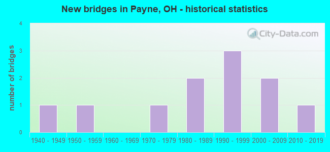
- New bridges - historical statistics
- 11940-1949
- 11950-1959
- 11970-1979
- 21980-1989
- 31990-1999
- 22000-2009
- 12010-2019
FCC Registered Cell Phone Towers:
1 (See the full list of FCC Registered Cell Phone Towers in Payne)FCC Registered Antenna Towers:
23 (See the full list of FCC Registered Antenna Towers)FCC Registered Broadcast Land Mobile Towers:
7- Lat: 41.079500 Lon: -84.727194, Call Sign: KNEY597,
Assigned Frequencies: 153.822 MHz, 155.842 MHz, 158.782 MHz, 159.382 MHz, Grant Date: 12/16/2022, Expiration Date: 03/08/2033, Registrant: Mcafees Communications Inc, 7678 Weitz Rd, Celina, OH 45822, Phone: (419) 586-3413, Fax: (419) 586-5246
- Cr 94 & 51 (Lat: 41.090056 Lon: -84.708278), Call Sign: WGH271,
Assigned Frequencies: 37.9000 MHz, Grant Date: 02/27/2004, Expiration Date: 04/19/2014, Cancellation Date: 06/21/2014, Registrant: Business Radio Licensing, 26941 Cabot Rd #134, Laguna Hillls, CA 92653, Phone: (949) 348-8510
- Hymen St (Lat: 41.081444 Lon: -84.724139), Call Sign: KZA291,
Assigned Frequencies: 154.540 MHz, Grant Date: 10/27/2000, Expiration Date: 11/26/2005, Cancellation Date: 01/28/2006, Registrant: Homier & Son, St Rt 613, Continental, OH 45831, Phone: (419) 263-2317
- Lat: 41.080861 Lon: -84.722889, Call Sign: WQCP462,
Assigned Frequencies: 451.187 MHz, 451.237 MHz, 451.287 MHz, 451.312 MHz, 451.337 MHz, Grant Date: 02/18/2015, Expiration Date: 04/22/2025, Cancellation Date: 03/30/2017, Certifier: Steve Queen, Registrant: J&k Communications, Inc., 222 South Tower View Drive, Columbia City, IN 46725, Phone: (260) 244-7975, Fax: (260) 244-3253
- Maple St, Rr Crossing At Maple St And Mp B349.50 (Lat: 41.080861 Lon: -84.722694), Type: Bant, Structure height: 2.5 m, Overall height: 3.1 m, Call Sign: WQCP887, Licensee ID: L00008014,
Assigned Frequencies: 161.250 MHz, 160.380 MHz, Grant Date: 01/29/2015, Expiration Date: 04/26/2025, Cancellation Date: 07/31/2023, Certifier: Jerry R Celio, Registrant: Norfolk Southern Railway Company, 650 West Peachtree, Nw / Box 41, Atlanta, GA 30308, Phone: (404) 660-4050, Fax: (404) 582-6209, Email:
- Lat: 41.079417 Lon: -84.726611, Call Sign: WQOS975,
Assigned Frequencies: 462.462 MHz, 467.462 MHz, Grant Date: 01/20/2012, Expiration Date: 01/20/2022, Cancellation Date: 03/26/2022, Certifier: Brian Alberts, Registrant: New Wave Licensing Services, Inc., 818 Taneytown Rd, Gettysburg, PA 17325, Phone: (717) 334-0910, Email:
- Lat: 41.080889 Lon: -84.726500, Call Sign: WQZB335,
Assigned Frequencies: 451.187 MHz, 451.237 MHz, 451.287 MHz, 451.312 MHz, 451.337 MHz, Grant Date: 03/27/2017, Expiration Date: 03/27/2027, Certifier: Dan Recker, Registrant: J&k Communications, Inc., 222 Towerview Drive, Columbia City, IN 46725, Phone: (260) 244-7975, Fax: (260) 244-3253, Email:
FCC Registered Microwave Towers:
13 (See the full list of FCC Registered Microwave Towers in this town)FCC Registered Amateur Radio Licenses:
8 (See the full list of FCC Registered Amateur Radio Licenses in Payne)2002 - 2018 National Fire Incident Reporting System (NFIRS) incidents
- Fire incident types reported to NFIRS in Payne, OH
- 13650.2%Structure Fires
- 10338.0%Outside Fires
- 3211.8%Mobile Property/Vehicle Fires
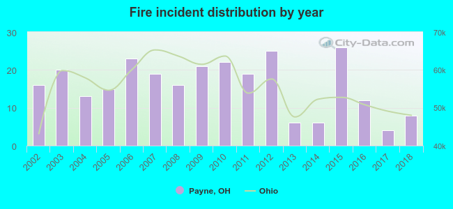 According to the data from the years 2002 - 2018 the average number of fires per year is 16. The highest number of fire incidents - 26 took place in 2015, and the least - 4 in 2017. The data has a dropping trend.
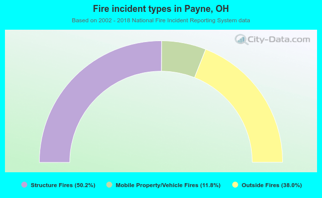 When looking into fire subcategories, the most incidents belonged to: Structure Fires (50.2%), and Outside Fires (38.0%).
| Most common first names in Payne, OH among deceased individuals | ||
| Name | Count | Lived (average) |
|---|---|---|
| John | 26 | 79.1 years |
| Mary | 21 | 84.1 years |
| William | 18 | 75.7 years |
| Helen | 18 | 81.5 years |
| Charles | 15 | 72.9 years |
| Richard | 11 | 68.2 years |
| Carl | 10 | 80.6 years |
| Harry | 10 | 80.1 years |
| Paul | 10 | 72.4 years |
| George | 9 | 73.4 years |
| Most common last names in Payne, OH among deceased individuals | ||
| Last name | Count | Lived (average) |
|---|---|---|
| Schaefer | 13 | 84.4 years |
| Zartman | 13 | 78.9 years |
| Hook | 11 | 79.2 years |
| King | 11 | 78.2 years |
| Overmyer | 9 | 80.7 years |
| Williams | 9 | 83.6 years |
| Smith | 7 | 80.7 years |
| Kuhn | 7 | 72.2 years |
| Snyder | 7 | 78.9 years |
| Bowers | 7 | 74.1 years |
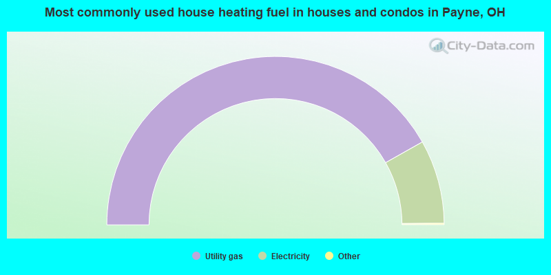
- 83.9%Utility gas
- 16.1%Electricity
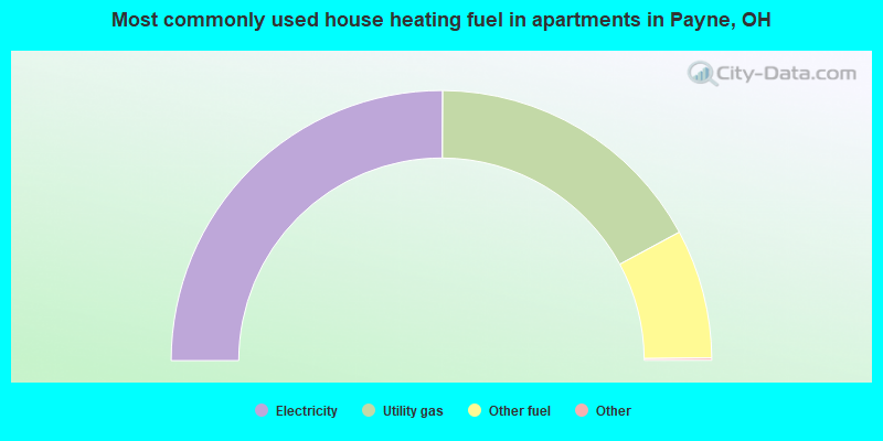
- 50.3%Electricity
- 34.2%Utility gas
- 15.5%Other fuel
Payne compared to Ohio state average:
- Median house value below state average.
- Unemployed percentage below state average.
- Black race population percentage significantly below state average.
- Foreign-born population percentage significantly below state average.
- Length of stay since moving in significantly above state average.
- House age above state average.

|
Total of 5 patent applications in 2008-2024.