Perry, Texas
Submit your own pictures of this place and show them to the world
- OSM Map
- General Map
- Google Map
- MSN Map

| Males: 361 | |
| Females: 346 |
| Median resident age: | 42.9 years |
| Texas median age: | 32.3 years |
Zip code: 76682
| Perry: | $57,880 |
| TX: | $72,284 |
Estimated per capita income in 2022: $34,889 (it was $16,836 in 2000)
Perry CCD income, earnings, and wages data
Estimated median house or condo value in 2022: $181,615 (it was $63,600 in 2000)
| Perry: | $181,615 |
| TX: | $275,400 |
Mean prices in 2022: all housing units: $174,426; detached houses: $169,007; townhouses or other attached units: $49,509; mobile homes: $240,346
Detailed information about poverty and poor residents in Perry, TX


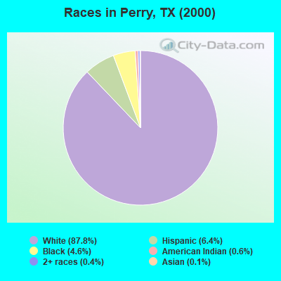
- 68287.8%White alone
- 506.4%Hispanic
- 364.6%Black alone
- 50.6%American Indian alone
- 30.4%Two or more races
- 10.1%Asian alone
Races in Perry detailed stats: ancestries, foreign born residents, place of birth
 Recent articles from our blog. Our writers, many of them Ph.D. graduates or candidates, create easy-to-read articles on a wide variety of topics.
Current Local Time: CST time zone
Land area: 89.5 square miles.
Population density: 7.9 people per square mile (very low).

| Perry CCD: | 0.8% ($504) |
| Texas: | 1.8% ($1,393) |
Nearest city with pop. 50,000+: Waco, TX  (19.2 miles , pop. 113,726).
Nearest city with pop. 200,000+: Arlington, TX (88.4 miles , pop. 332,969).
Nearest city with pop. 1,000,000+: Dallas, TX (93.6 miles , pop. 1,188,580).
Nearest cities:
), ), ), )Latitude: 31.45 N, Longitude: 96.85 W
Area code commonly used in this area: 254

| Here: | 3.5% |
| Texas: | 3.5% |
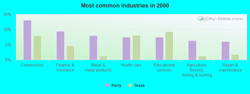
- Construction (13.1%)
- Finance & insurance (9.5%)
- Metal & metal products (8.1%)
- Health care (7.5%)
- Educational services (7.5%)
- Agriculture, forestry, fishing & hunting (6.4%)
- Repair & maintenance (6.1%)
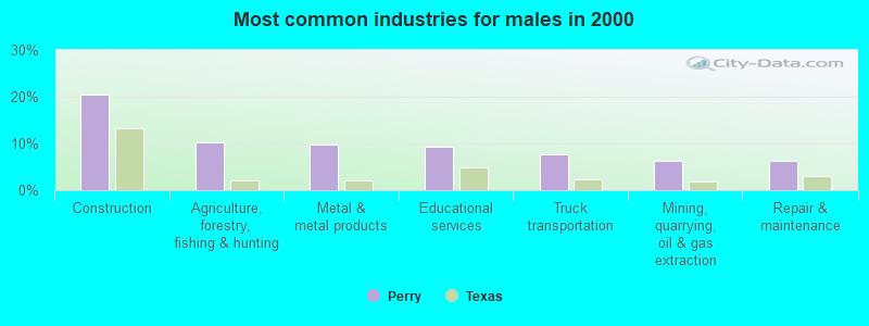
- Construction (20.4%)
- Agriculture, forestry, fishing & hunting (10.2%)
- Metal & metal products (9.8%)
- Educational services (9.3%)
- Truck transportation (7.6%)
- Mining, quarrying, oil & gas extraction (6.2%)
- Repair & maintenance (6.2%)
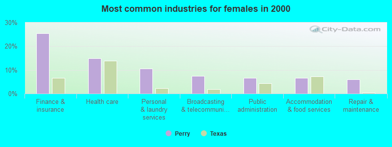
- Finance & insurance (25.4%)
- Health care (14.9%)
- Personal & laundry services (10.4%)
- Broadcasting & telecommunications (7.5%)
- Public administration (6.7%)
- Accommodation & food services (6.7%)
- Repair & maintenance (6.0%)
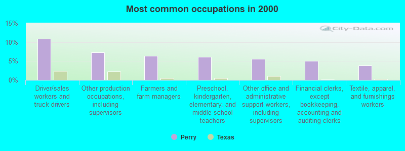
- Driver/sales workers and truck drivers (10.9%)
- Other production occupations, including supervisors (7.2%)
- Farmers and farm managers (6.4%)
- Preschool, kindergarten, elementary, and middle school teachers (6.1%)
- Other office and administrative support workers, including supervisors (5.6%)
- Financial clerks, except bookkeeping, accounting and auditing clerks (5.0%)
- Textile, apparel, and furnishings workers (3.9%)
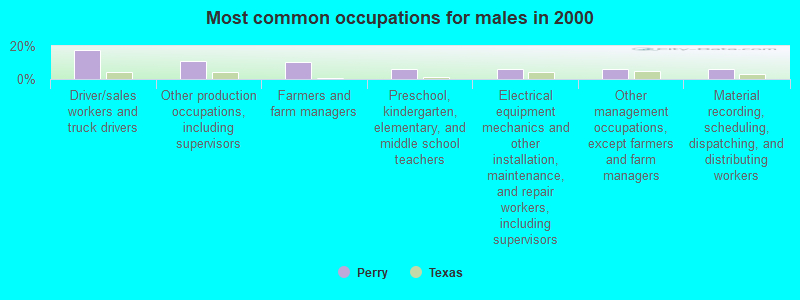
- Driver/sales workers and truck drivers (17.3%)
- Other production occupations, including supervisors (10.7%)
- Farmers and farm managers (10.2%)
- Preschool, kindergarten, elementary, and middle school teachers (6.2%)
- Electrical equipment mechanics and other installation, maintenance, and repair workers, including supervisors (6.2%)
- Other management occupations, except farmers and farm managers (5.8%)
- Material recording, scheduling, dispatching, and distributing workers (5.8%)
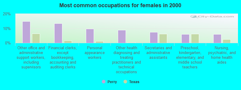
- Other office and administrative support workers, including supervisors (14.9%)
- Financial clerks, except bookkeeping, accounting and auditing clerks (13.4%)
- Personal appearance workers (9.7%)
- Other health diagnosing and treating practitioners and technical occupations (9.0%)
- Secretaries and administrative assistants (7.5%)
- Preschool, kindergarten, elementary, and middle school teachers (6.0%)
- Nursing, psychiatric, and home health aides (6.0%)
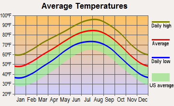
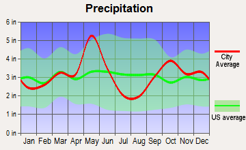
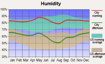
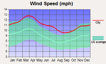
Average climate in Perry, Texas
Based on data reported by over 4,000 weather stations
(lower is better)
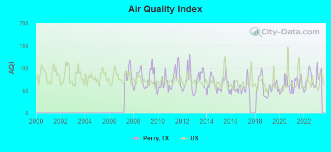
Air Quality Index (AQI) level in 2022 was 71.7. This is about average.
| City: | 71.7 |
| U.S.: | 72.6 |
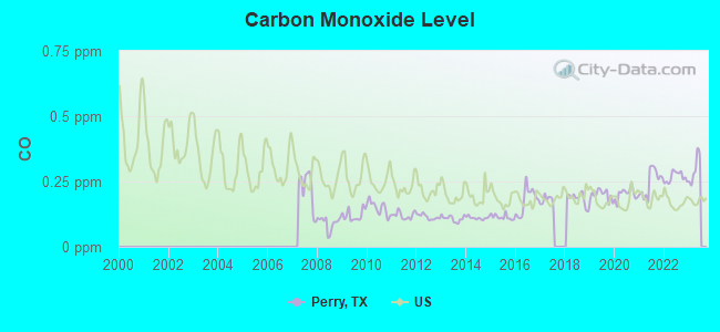
Carbon Monoxide (CO) [ppm] level in 2022 was 0.267. This is about average. Closest monitor was 19.1 miles away from the city center.
| City: | 0.267 |
| U.S.: | 0.251 |
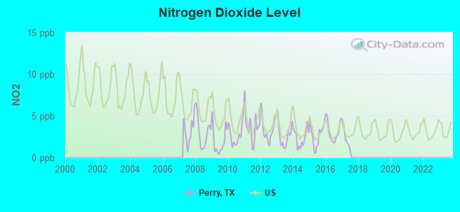
Nitrogen Dioxide (NO2) [ppb] level in 2017 was 2.33. This is significantly better than average. Closest monitor was 19.1 miles away from the city center.
| City: | 2.33 |
| U.S.: | 5.11 |
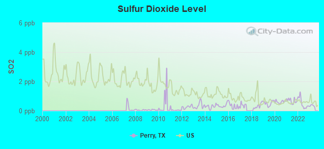
Sulfur Dioxide (SO2) [ppb] level in 2022 was 0.494. This is significantly better than average. Closest monitor was 19.1 miles away from the city center.
| City: | 0.494 |
| U.S.: | 1.515 |
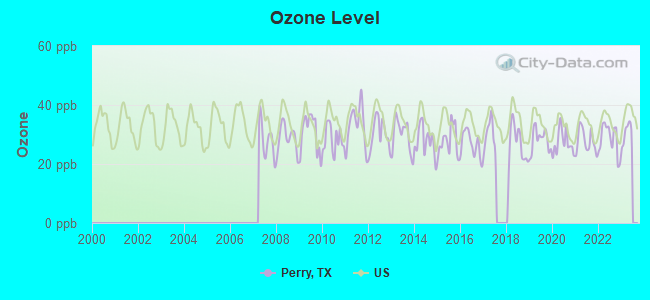
Ozone [ppb] level in 2022 was 28.5. This is about average. Closest monitor was 18.1 miles away from the city center.
| City: | 28.5 |
| U.S.: | 33.3 |
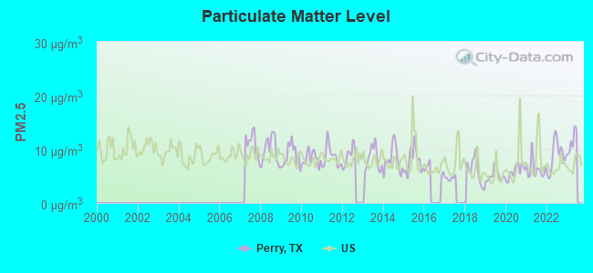
Particulate Matter (PM2.5) [µg/m3] level in 2022 was 8.80. This is about average. Closest monitor was 21.0 miles away from the city center.
| City: | 8.80 |
| U.S.: | 8.11 |
Tornado activity:
Perry-area historical tornado activity is slightly above Texas state average. It is 68% greater than the overall U.S. average.
On 5/11/1953, a category F5 (max. wind speeds 261-318 mph) tornado 18.8 miles away from the Perry place center killed 114 people and injured 597 people and caused between $5,000,000 and $50,000,000 in damages.
On 3/10/1973, a category F4 (max. wind speeds 207-260 mph) tornado 5.9 miles away from the place center killed 6 people and injured 77 people.
Earthquake activity:
Perry-area historical earthquake activity is significantly above Texas state average. It is 318% greater than the overall U.S. average.On 11/6/2011 at 03:53:10, a magnitude 5.7 (5.7 MW, Depth: 3.2 mi, Class: Moderate, Intensity: VI - VII) earthquake occurred 282.6 miles away from the city center
On 5/17/2012 at 08:12:00, a magnitude 4.8 (4.8 MW, Depth: 3.1 mi, Class: Light, Intensity: IV - V) earthquake occurred 150.0 miles away from the city center
On 9/3/2016 at 12:02:44, a magnitude 5.8 (5.8 MW, Depth: 3.5 mi) earthquake occurred 344.3 miles away from Perry center
On 6/16/1978 at 11:46:54, a magnitude 5.3 (4.4 MB, 4.6 UK, 5.3 ML) earthquake occurred 253.7 miles away from the city center
On 10/20/2011 at 12:24:41, a magnitude 4.8 (4.8 MW, Depth: 3.1 mi) earthquake occurred 193.0 miles away from Perry center
On 5/7/2015 at 22:58:05, a magnitude 4.0 (4.0 MW, Depth: 1.6 mi) earthquake occurred 73.0 miles away from the city center
Magnitude types: body-wave magnitude (MB), local magnitude (ML), moment magnitude (MW)
Natural disasters:
The number of natural disasters in Falls County (9) is smaller than the US average (15).Major Disasters (Presidential) Declared: 3
Emergencies Declared: 5
Causes of natural disasters: Fires: 3, Hurricanes: 3, Floods: 2, Storms: 2, Other: 1 (Note: some incidents may be assigned to more than one category).
Hospitals and medical centers near Perry:
- PARK PLAZA (Nursing Home, about 8 miles away; MART, TX)
- PARK PLAZA NURSING HOME (Nursing Home, about 8 miles away; MART, TX)
- ROBERT E LEE GROUP HOME (Hospital, about 9 miles away; MARLIN, TX)
- ELMWOOD NURSING CENTER (Nursing Home, about 10 miles away; MARLIN, TX)
- FOSTER GROUP HOME (Hospital, about 10 miles away; MARLIN, TX)
- GOLDEN YEARS NURSING AND REHABILITATION CENTER (Nursing Home, about 10 miles away; MARLIN, TX)
- GOLDEN YEARS REST HOME (Nursing Home, about 10 miles away; MARLIN, TX)
Colleges/universities with over 2000 students nearest to Perry:
- Baylor University (about 18 miles; Waco, TX; Full-time enrollment: 14,800)
- Texas State Technical College-Waco (about 19 miles; Waco, TX; FT enrollment: 4,210)
- McLennan Community College (about 22 miles; Waco, TX; FT enrollment: 6,673)
- Temple College (about 40 miles; Temple, TX; FT enrollment: 3,796)
- Hill College (about 42 miles; Hillsboro, TX; FT enrollment: 2,968)
- University of Mary Hardin-Baylor (about 45 miles; Belton, TX; FT enrollment: 2,885)
- Navarro College (about 49 miles; Corsicana, TX; FT enrollment: 7,711)
Points of interest:
Notable locations in Perry: Brushy Bluff Church (A), Eureka School (B). Display/hide their locations on the map
Churches in Perry include: Perry Church (A), Trinity Church (B), Sunset Church (C), Saint Johns Church (D), Criswell Church (E), Nazare Church (F), New Zion Church (G). Display/hide their locations on the map
Cemeteries: Hope Cemetery (1), Walker Cemetery (2), Sunset Cemetery (3), Metina Cemetery (4), Nazare Cemetery (5), Zion Cemetery (6). Display/hide their locations on the map
Reservoirs: Mann Lake (A), Able Lake (B). Display/hide their locations on the map
Creeks: Sandy Creek (A), Little Brushy Creek (B), Hogpen Creek (C), Cottonwood Creek (D), Little Elm Creek (E). Display/hide their locations on the map
| This place: | 2.3 people |
| Texas: | 2.8 people |
| This place: | 67.3% |
| Whole state: | 69.9% |
| This place: | 4.2% |
| Whole state: | 6.0% |
Likely homosexual households (counted as self-reported same-sex unmarried-partner households)
- Lesbian couples: 0.3% of all households
- Gay men: 0.3% of all households
| This place: | 9.8% |
| Whole state: | 15.4% |
| This place: | 7.4% |
| Whole state: | 6.7% |
2 people in nursing homes in 2000
For population 15 years and over in Perry:

- Never married: 9.0%
- Now married: 73.4%
- Separated: 2.7%
- Widowed: 11.7%
- Divorced: 5.9%
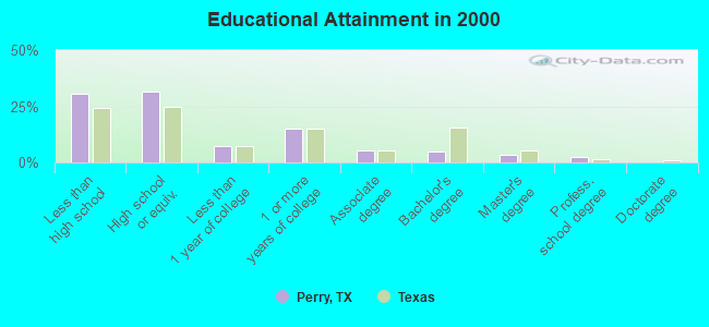
For population 25 years and over in Perry:
- High school or higher: 69.6%
- Bachelor's degree or higher: 10.5%
- Graduate or professional degree: 5.8%
- Unemployed: 5.8%
- Mean travel time to work (commute): 29.9 minutes
| Here: | 13.7 |
| Texas average: | 15.6 |
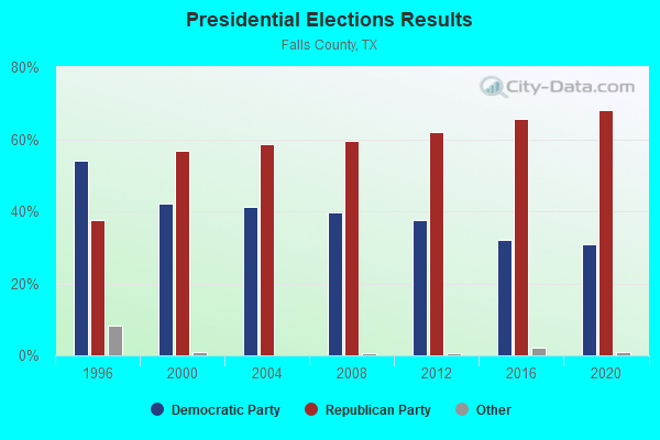
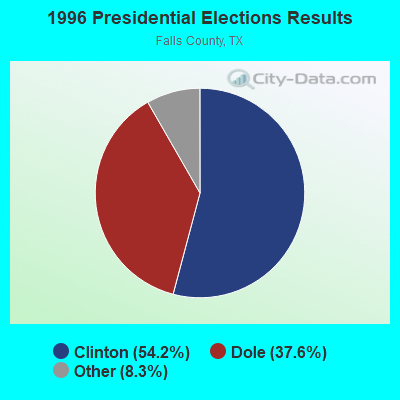
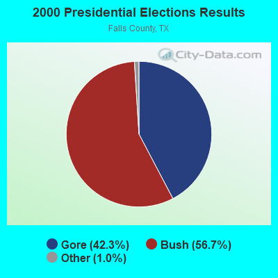
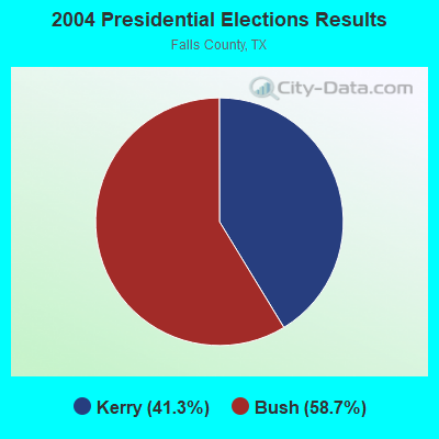
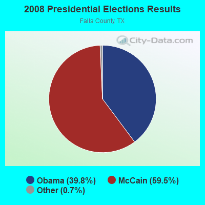
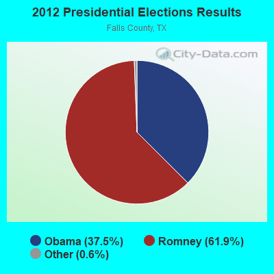
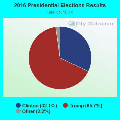
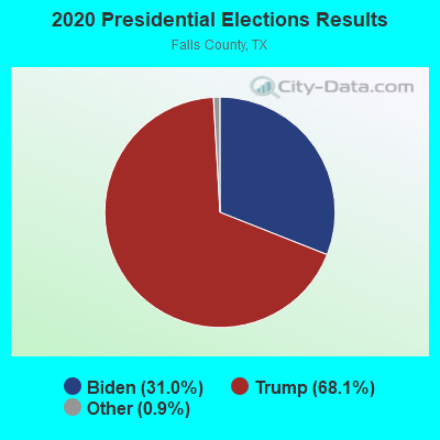
Graphs represent county-level data. Detailed 2008 Election Results
Religion statistics for Perry, TX (based on Falls County data)
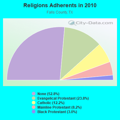

| Religion | Adherents | Congregations |
|---|---|---|
| Evangelical Protestant | 4,251 | 30 |
| Catholic | 2,179 | 5 |
| Mainline Protestant | 1,467 | 16 |
| Black Protestant | 540 | 3 |
| Other | 3 | 1 |
| None | 9,426 | - |
Food Environment Statistics:
| Here: | 1.77 / 10,000 pop. |
| Texas: | 1.47 / 10,000 pop. |
| This county: | 1.77 / 10,000 pop. |
| Texas: | 1.11 / 10,000 pop. |
| Falls County: | 5.90 / 10,000 pop. |
| Texas: | 3.95 / 10,000 pop. |
| Falls County: | 5.90 / 10,000 pop. |
| State: | 6.13 / 10,000 pop. |
| Falls County: | 10.8% |
| State: | 8.9% |
| Falls County: | 29.3% |
| Texas: | 26.6% |
| Falls County: | 16.7% |
| Texas: | 15.7% |
Strongest AM radio stations in Perry:
- KBBW (1010 AM; 10 kW; WACO-MARLIN, TX; Owner: AMERICAN BROADCASTING OF TEXAS)
- KRZI (1580 AM; 10 kW; WACO, TX; Owner: VAN D. GOODALL, JR.)
- KRZX (1660 AM; 10 kW; WACO, TX; Owner: VAN D. GOODALL, JR.)
- WBAP (820 AM; 50 kW; FORT WORTH, TX; Owner: WBAP-KSCS OPERATING, LTD.)
- KESS (1270 AM; 50 kW; FORT WORTH, TX; Owner: KESS-AM LICENSE CORP.)
- KRLD (1080 AM; 50 kW; DALLAS, TX; Owner: TEXAS INFINITY BROADCASTING L.P.)
- KAHZ (1360 AM; 50 kW; HURST, TX)
- KFXR (1190 AM; 50 kW; DALLAS, TX; Owner: CLEAR CHANNEL BROADCASTING LICENSES, INC.)
- KZMP (1540 AM; 50 kW; UNIVERSITY PARK, TX; Owner: ENTRAVISION HOLDINGS, LLC)
- KSKY (660 AM; 20 kW; BALCH SPRINGS, TX; Owner: BISON MEDIA, INC.)
- KWTX (1230 AM; 1 kW; WACO, TX; Owner: CAPSTAR TX LIMITED PARTNERSHIP)
- KTRH (740 AM; 50 kW; HOUSTON, TX; Owner: AMFM TEXAS LICENSES LIMITED PARTNERSHIP)
- KGOL (1180 AM; 50 kW; HUMBLE, TX; Owner: ENTRAVISION HOLDINGS, LLC)
Strongest FM radio stations in Perry:
- WACO-FM (99.9 FM; WACO, TX; Owner: CAPSTAR TX LIMITED PARTNERSHIP)
- KWTX-FM (97.5 FM; WACO, TX; Owner: CAPSTAR TX LIMITED PARTNERSHIP)
- KBGO (95.7 FM; WACO, TX; Owner: CAPSTAR TX LIMITED PARTNERSHIP)
- KWBU-FM (103.3 FM; WACO, TX; Owner: BRAZOS VALLEY PUBLIC BROADCASTING FOUNDATION)
- KBCT (94.5 FM; WACO, TX; Owner: KENNELWOOD BCST/G COMPANY, INC.)
- KLRK (92.9 FM; MARLIN, TX; Owner: VAN D. GOODALL, JR.)
- KDOS (107.9 FM; ROBINSON, TX; Owner: KICI-FM LICENSE CORP.)
TV broadcast stations around Perry:
- KCEN-TV (Channel 6; TEMPLE, TX; Owner: CHANNEL 6, INC.)
- KXXV (Channel 25; WACO, TX; Owner: CENTEX TELEVISION LIMITED PARTNERSHIP)
- KWBU-TV (Channel 34; WACO, TX; Owner: BRAZOS VALLEY PUBLIC BROADCASTING FOUNDATION)
- KWKT (Channel 44; WACO, TX; Owner: COMCORP OF TEXAS LICENSE CORP.)
- KWTX-TV (Channel 10; WACO, TX; Owner: KWTX-KBTX LICENSEE CORP.)
- KYLE (Channel 28; BRYAN, TX; Owner: COMCORP OF BRYAN LICENSE CORP.)
Perry fatal accident list:
Nov 11, 1980 06:50 PM, Vehicles: 2, Persons: 2, Fatalities: 1, Drunk persons involved: 1
FCC Registered Broadcast Land Mobile Towers:
1- MP 148.9, Mp 148.9 Fort Worth Sub Ded (Lat: 31.442722 Lon: -96.923528), Type: Bant, Structure height: 4 m, Call Sign: WQRN498,
Assigned Frequencies: 160.515 MHz, 161.280 MHz, 160.830 MHz, Grant Date: 05/17/2023, Expiration Date: 06/25/2033, Certifier: Thomas J Mcgovern, Registrant: Concentrix, 222 So 15th St Suite 505 N, Omaha, NE 68102, Phone: (402) 262-4785, Email:
FCC Registered Microwave Towers:
2- Perry, 2.5 Mi E Of (Lat: 31.440028 Lon: -96.875972), Type: Ltower, Structure height: 39.6 m, Overall height: 43.3 m, Call Sign: WNTA702,
Assigned Frequencies: 6600.00 MHz, 6685.00 MHz, 6665.00 MHz, 6645.00 MHz, 6645.00 MHz, 6645.00 MHz, 6645.00 MHz, 6063.80 MHz, 6063.80 MHz, 6063.80 MHz... (+25 more), Grant Date: 05/24/2019, Expiration Date: 04/12/2029, Registrant: Brazos Electric Power Cooperative, Inc., 2404 Lasalle Ave., Waco, TX 76702-2585, Phone: (254) 750-6385, Fax: (254) 750-6590, Email:
- North Tower, Intersection Of Cr 118 & Cr 146, 3.38 Miles North Of Perry, Tx (Lat: 31.460000 Lon: -96.887389), Type: Tower, Structure height: 48.8 m, Overall height: 54.6 m, Call Sign: WQFF431,
Assigned Frequencies: 942.975 MHz, Grant Date: 04/06/2016, Expiration Date: 06/30/2026, Certifier: Rob Douglas, Registrant: Huffman Communications, 2829 W. 7th Ave, Corsicana, TX 75151-1753, Phone: (903) 872-8306, Fax: (903) 872-6032, Email:
FCC Registered Paging Towers:
1- 5 Miles Sw Of Perry (Lat: 41.767472 Lon: -94.162722), Call Sign: KKB608, Licensee ID: L00011049,
Assigned Frequencies: 43.5800 MHz, Grant Date: 05/11/1999, Expiration Date: 04/01/2009, Cancellation Date: 02/24/2009, Registrant: West Central Pagers, Inc., 1421 Second Street, Perry, IA 50220
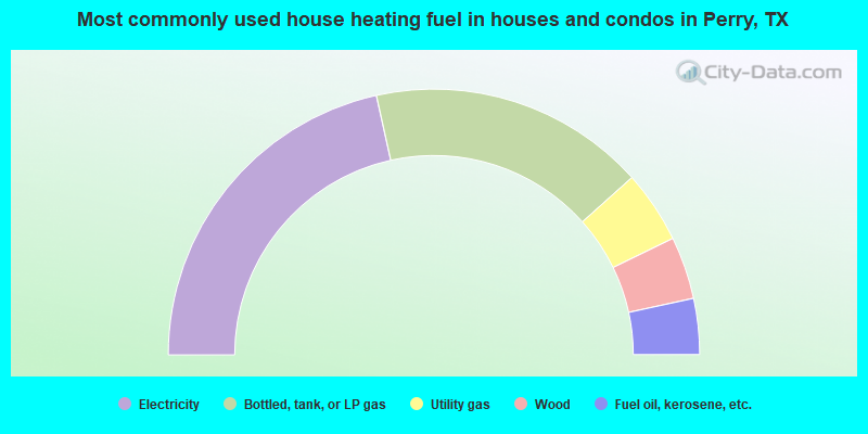
- 43.0%Electricity
- 33.7%Bottled, tank, or LP gas
- 8.8%Utility gas
- 7.6%Wood
- 6.8%Fuel oil, kerosene, etc.
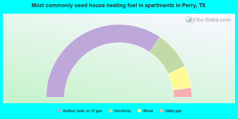
- 69.0%Bottled, tank, or LP gas
- 16.9%Electricity
- 9.9%Wood
- 4.2%Utility gas
Perry compared to Texas state average:
- Median house value below state average.
- Unemployed percentage below state average.
- Black race population percentage below state average.
- Hispanic race population percentage significantly below state average.
- Median age significantly above state average.
- Foreign-born population percentage significantly below state average.
- Renting percentage below state average.
- Length of stay since moving in significantly above state average.
- Number of rooms per house significantly below state average.
- House age significantly below state average.
- Number of college students below state average.
- Percentage of population with a bachelor's degree or higher below state average.