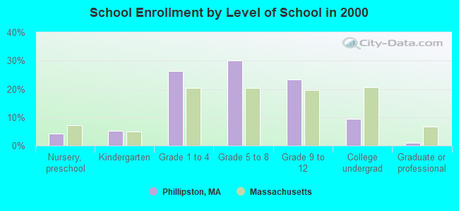
Phillipston, Massachusetts
Submit your own pictures of this town and show them to the world
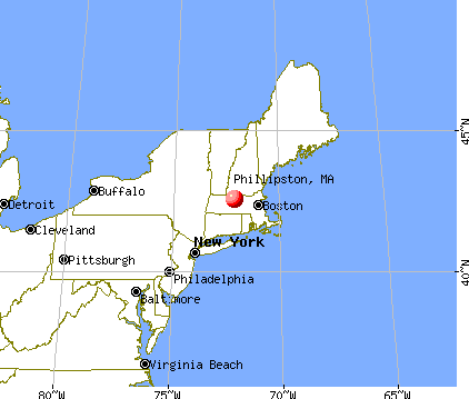
- OSM Map
- General Map
- Google Map
- MSN Map

Population change since 2000: +3.8%
 |
| Males: 853 | |
| Females: 829 |
| Median resident age: | 42.7 years |
| Massachusetts median age: | 39.2 years |
Zip codes: 01331.
| Phillipston: | $84,404 |
| MA: | $94,488 |
Estimated per capita income in 2022: $36,473 (it was $18,706 in 2000)
Phillipston town income, earnings, and wages data
Estimated median house or condo value in 2022: $327,246 (it was $118,500 in 2000)
| Phillipston: | $327,246 |
| MA: | $534,700 |
Mean prices in 2022: all housing units: $419,164; detached houses: $447,621; townhouses or other attached units: $343,592; in 2-unit structures: $323,295; in 3-to-4-unit structures: $332,295; in 5-or-more-unit structures: $232,758; mobile homes: $113,885
Detailed information about poverty and poor residents in Phillipston, MA
Compare current foreclosures near Phillipston, MA:
| Photo | Address | Area | Beds / Baths | Price | Details |
|---|---|---|---|---|---|

|
#1
Iriquois Dr
Ashburnham, MA 01430
|
2,016 sq. feet
|
2 baths 3 beds |
$369,000
|
show details |

|
#2
Parker St
Gardner, MA 01440
|
1,980 sq. feet
|
2 baths 4 beds |
$469,900
|
show details |

|
#3
Whipple Hill Rd
Winchester, NH 03470
|
1,374 sq. feet
|
2 baths 2 beds |
$379,900
|
show details |

|
#4
Hardwick Road
Hardwick, MA 01037
|
- sq. feet
|
1 baths 3 beds |
$244,900
|
show details |

|
#5
Juniper St
Winchendon, MA 01475
|
1,687 sq. feet
|
1 baths 4 beds |
show details | |

|
#6
Noel Dr
Ashburnham, MA 01430
|
960 sq. feet
|
1 baths 3 beds |
show details | |

|
#7
Root Rd
Barre, MA 01005
|
3,528 sq. feet
|
2 baths 4 beds |
show details | |

|
#8
Carter Rd
Westminster, MA 01473
|
2,182 sq. feet
|
1 baths 3 beds |
show details | |

|
#9
Wauwinet Rd
Barre, MA 01005
|
2,560 sq. feet
|
2 baths 5 beds |
show details | |

|
#10
W Main St
New Salem, MA 01355
|
4,624 sq. feet
|
3 baths 6 beds |
show details |
| Photo | Address | Area | Beds / Baths | Price | Details |
|---|---|---|---|---|---|

|
#11
Healdville Rd
Hubbardston, MA 01452
|
936 sq. feet
|
1 baths 2 beds |
show details | |

|
#12
Maple St
Winchendon, MA 01475
|
1,000 sq. feet
|
1 baths 2 beds |
show details | |

|
#13
Springhill Rd
Barre, MA 01005
|
1,075 sq. feet
|
1 baths 2 beds |
show details | |

|
#14
Maple St
Winchendon, MA 01475
|
903 sq. feet
|
1 baths 2 beds |
show details | |

|
#15
West St
Winchendon, MA 01475
|
1,584 sq. feet
|
1 baths 3 beds |
show details | |

|
#16
Old Dana Rd
Barre, MA 01005
|
1,255 sq. feet
|
1 baths 3 beds |
show details | |

|
#17
Queen Lake Rd
Athol, MA 01331
|
3,416 sq. feet
|
2 baths 4 beds |
show details | |

|
#18
School St
Winchendon, MA 01475
|
1,518 sq. feet
|
1 baths 3 beds |
show details | |

|
#19
S Barre Rd
Barre, MA 01005
|
1,640 sq. feet
|
1 baths 3 beds |
show details | |

|
#20
Lake Mattawa Rd
Orange, MA 01364
|
1,666 sq. feet
|
1 baths 3 beds |
show details |
| Photo | Address | Area | Beds / Baths | Price | Details |
|---|---|---|---|---|---|

|
#21
Maynard St
Orange, MA 01364
|
1,640 sq. feet
|
2 baths 3 beds |
show details | |

|
#22
Pearly Ln
Gardner, MA 01440
|
1,728 sq. feet
|
2 baths 4 beds |
show details | |

|
#23
Converse Dr
Winchendon, MA 01475
|
2,120 sq. feet
|
3 baths 3 beds |
show details | |

|
#24
Willis Rd
Gardner, MA 01440
|
2,451 sq. feet
|
2 baths 3 beds |
show details | |

|
#25
Converse Dr
Winchendon, MA 01475
|
2,108 sq. feet
|
1 baths 3 beds |
show details | |

|
#26
Templeton Rd
Athol, MA 01331
|
960 sq. feet
|
1 baths 2 beds |
show details | |

|
#27
N Main St, Unit A
Orange, MA 01364
|
598 sq. feet
|
1 baths 2 beds |
show details | |

|
#28
Whitney St
Gardner, MA 01440
|
2,026 sq. feet
|
2 baths 3 beds |
show details | |

|
#29
Stone St
Gardner, MA 01440
|
1,908 sq. feet
|
2 baths 3 beds |
show details | |

|
#30
Teel Rd
Winchendon, MA 01475
|
1,080 sq. feet
|
1 baths 3 beds |
show details |
| Photo | Address | Area | Beds / Baths | Price | Details |
|---|---|---|---|---|---|

|
#31
Hill St
Winchendon, MA 01475
|
1,549 sq. feet
|
1 baths 3 beds |
show details | |

|
#32
Eddy St
Orange, MA 01364
|
1,116 sq. feet
|
1 baths 2 beds |
show details | |

|
#33
Spruce St
Winchendon, MA 01475
|
1,504 sq. feet
|
1 baths 3 beds |
show details | |

|
#34
Monomonac Ter
Rindge, NH 03461
|
1,024 sq. feet
|
1 baths 3 beds |
show details | |

|
#35
Cushing St
Ashburnham, MA 01430
|
1,445 sq. feet
|
1 baths 3 beds |
show details | |

|
#36
N Brookfield Rd
Oakham, MA 01068
|
1,240 sq. feet
|
2 baths 3 beds |
show details | |

|
#37
Oakridge Dr
Rutland, MA 01543
|
1,190 sq. feet
|
1 baths 3 beds |
show details | |

|
#38
Pratt St
Fitchburg, MA 01420
|
862 sq. feet
|
1 baths 2 beds |
show details | |

|
#39
Clarendon St
Fitchburg, MA 01420
|
2,488 sq. feet
|
2 baths 4 beds |
show details | |

|
#40
Lionel Ave
Fitchburg, MA 01420
|
1,302 sq. feet
|
1 baths 3 beds |
show details |
| Photo | Address | Area | Beds / Baths | Price | Details |
|---|---|---|---|---|---|

|
#41
Shea St
Fitchburg, MA 01420
|
1,332 sq. feet
|
1 baths 2 beds |
show details | |

|
#42
Colonial Dr
Rutland, MA 01543
|
1,772 sq. feet
|
2 baths 3 beds |
show details | |

|
#43
Worcester Rd
Princeton, MA 01541
|
2,093 sq. feet
|
2 baths 4 beds |
show details | |

|
#44
Old New Ipswich Rd
Rindge, NH 03461
|
1,184 sq. feet
|
2 baths 3 beds |
show details | |

|
#45
Britney Dr
Rutland, MA 01543
|
1,672 sq. feet
|
1 baths 3 beds |
show details | |

|
#46
Fairmount St
Fitchburg, MA 01420
|
1,456 sq. feet
|
1 baths 3 beds |
show details | |

|
#47
Ashburnham St
Fitchburg, MA 01420
|
2,095 sq. feet
|
1 baths 3 beds |
show details | |

|
#48
Fitzgerald Rd
Rindge, NH 03461
|
3,960 sq. feet
|
3 baths 4 beds |
show details | |

|
#49
Birch Dr
Rindge, NH 03461
|
1,971 sq. feet
|
2 baths 4 beds |
show details | |

|
Check over 1 million property listings on Foreclosure.com!
|
browse all offers | |||

- 1,59394.7%White alone
- 382.3%Hispanic
- 221.3%Two or more races
- 201.2%Black alone
- 90.5%Asian alone
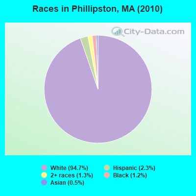
Races in Phillipston detailed stats: ancestries, foreign born residents, place of birth
According to our research of Massachusetts and other state lists, there were 3 registered sex offenders living in Phillipston, Massachusetts as of May 19, 2024.
The ratio of all residents to sex offenders in Phillipston is 561 to 1.
Full-time law enforcement employees in 2018, including police officers: 2 (2 officers - 2 male; 0 female).
| Officers per 1,000 residents here: | 1.14 |
| Massachusetts average: | 2.60 |
 Recent articles from our blog. Our writers, many of them Ph.D. graduates or candidates, create easy-to-read articles on a wide variety of topics.

 | How Much Massachusetts Households Make Per Year: Census Data (37 replies) |
| Boundaries of MA's regions (63 replies) |
| 'Do Bostonians really care about Western MA' Globe article (75 replies) |
| Heroin problem in Massachusetts and Anthony Bourdain's spotlight on it (45 replies) |
| Schools in Worcester county (19 replies) |
| Affordable country areas between Templeton and Fitchburg, Mass (25 replies) |
Latest news from Phillipston, MA collected exclusively by city-data.com from local newspapers, TV, and radio stations
Ancestries: French (22.1%), Irish (15.2%), English (14.8%), French Canadian (10.2%), United States (6.6%), Italian (6.5%).
Current Local Time: EST time zone
Incorporated in 1786
Elevation: 1166 feet
Land area: 24.3 square miles.
Population density: 69 people per square mile (very low).
18 residents are foreign born
| This town: | 1.1% |
| Massachusetts: | 12.2% |
| Phillipston town: | 1.2% ($1,429) |
| Massachusetts: | 1.3% ($2,336) |
Nearest city with pop. 50,000+: Worcester, MA  (26.8 miles , pop. 172,648).
Nearest city with pop. 200,000+: Boston, MA (56.2 miles , pop. 589,141).
Nearest city with pop. 1,000,000+: Bronx, NY (148.8 miles , pop. 1,332,650).
Nearest cities:
Latitude: 42.57 N, Longitude: 72.14 W
Area code commonly used in this area: 978

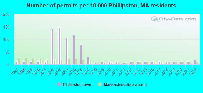
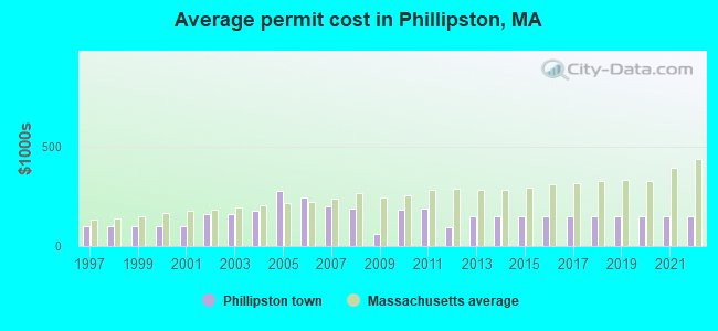
Single-family new house construction building permits:
- 2022: 3 buildings, average cost: $151,000
- 2021: 2 buildings, average cost: $151,000
- 2020: 2 buildings, average cost: $151,000
- 2019: 2 buildings, average cost: $151,000
- 2018: 2 buildings, average cost: $151,000
- 2017: 2 buildings, average cost: $151,000
- 2016: 2 buildings, average cost: $151,000
- 2015: 2 buildings, average cost: $151,000
- 2014: 2 buildings, average cost: $151,000
- 2013: 2 buildings, average cost: $150,000
- 2012: 1 building, cost: $95,000
- 2011: 2 buildings, average cost: $190,000
- 2010: 2 buildings, average cost: $181,200
- 2009: 2 buildings, average cost: $59,600
- 2008: 1 building, cost: $186,000
- 2007: 5 buildings, average cost: $199,200
- 2006: 13 buildings, average cost: $245,000
- 2005: 19 buildings, average cost: $276,200
- 2004: 17 buildings, average cost: $176,800
- 2003: 24 buildings, average cost: $163,200
- 2002: 23 buildings, average cost: $163,200
- 2001: 2 buildings, average cost: $102,300
- 2000: 2 buildings, average cost: $102,300
- 1999: 2 buildings, average cost: $102,300
- 1998: 2 buildings, average cost: $102,300
- 1997: 2 buildings, average cost: $102,300
| Here: | 2.6% |
| Massachusetts: | 3.5% |

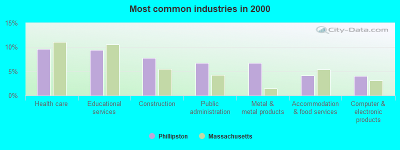
- Health care (9.7%)
- Educational services (9.4%)
- Construction (7.8%)
- Public administration (6.7%)
- Metal & metal products (6.7%)
- Accommodation & food services (4.2%)
- Computer & electronic products (4.1%)

- Construction (13.7%)
- Metal & metal products (8.2%)
- Public administration (7.5%)
- Educational services (5.8%)
- Computer & electronic products (4.7%)
- Accommodation & food services (4.1%)
- Repair & maintenance (3.9%)
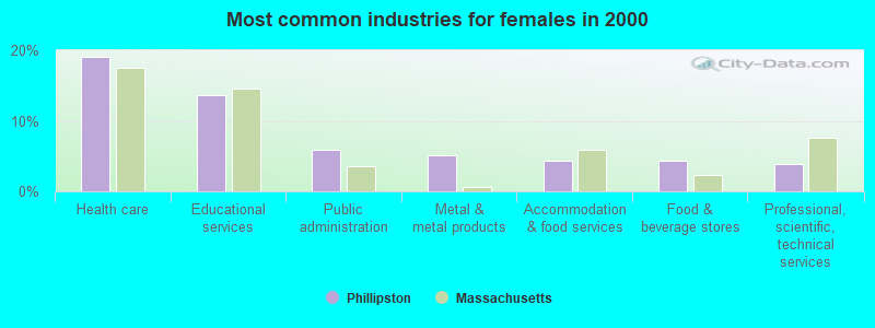
- Health care (19.0%)
- Educational services (13.7%)
- Public administration (5.8%)
- Metal & metal products (5.1%)
- Accommodation & food services (4.3%)
- Food & beverage stores (4.3%)
- Professional, scientific, technical services (3.8%)
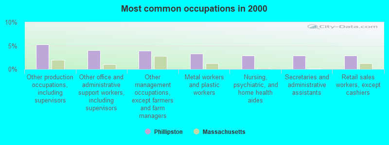
- Other production occupations, including supervisors (5.2%)
- Other office and administrative support workers, including supervisors (4.1%)
- Other management occupations, except farmers and farm managers (4.0%)
- Metal workers and plastic workers (3.3%)
- Nursing, psychiatric, and home health aides (2.9%)
- Secretaries and administrative assistants (2.9%)
- Retail sales workers, except cashiers (2.9%)
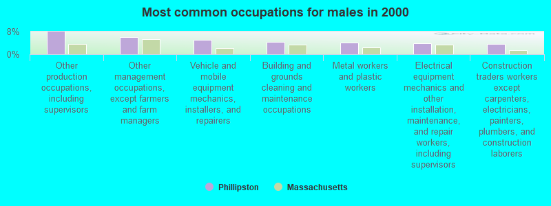
- Other production occupations, including supervisors (7.9%)
- Other management occupations, except farmers and farm managers (6.0%)
- Vehicle and mobile equipment mechanics, installers, and repairers (5.2%)
- Building and grounds cleaning and maintenance occupations (4.3%)
- Metal workers and plastic workers (4.1%)
- Electrical equipment mechanics and other installation, maintenance, and repair workers, including supervisors (3.9%)
- Construction traders workers except carpenters, electricians, painters, plumbers, and construction laborers (3.6%)
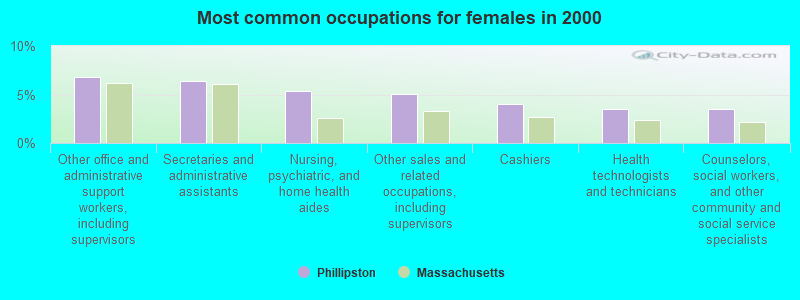
- Other office and administrative support workers, including supervisors (6.9%)
- Secretaries and administrative assistants (6.3%)
- Nursing, psychiatric, and home health aides (5.3%)
- Other sales and related occupations, including supervisors (5.1%)
- Cashiers (4.1%)
- Health technologists and technicians (3.6%)
- Counselors, social workers, and other community and social service specialists (3.6%)
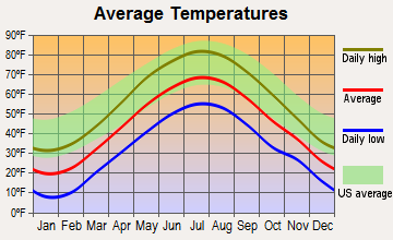
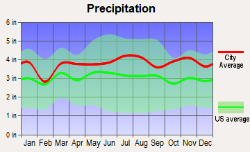
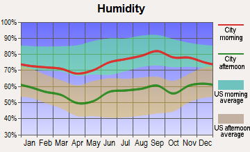
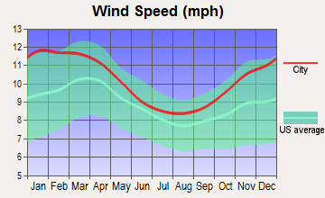
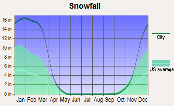
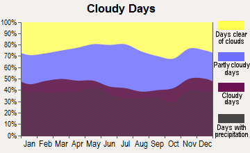
Average climate in Phillipston, Massachusetts
Based on data reported by over 4,000 weather stations
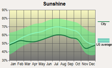
(lower is better)
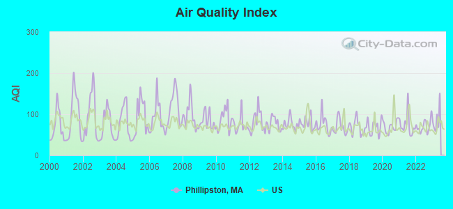
Air Quality Index (AQI) level in 2022 was 70.9. This is about average.
| City: | 70.9 |
| U.S.: | 72.6 |
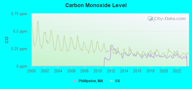
Carbon Monoxide (CO) [ppm] level in 2022 was 0.131. This is significantly better than average. Closest monitor was 24.4 miles away from the city center.
| City: | 0.131 |
| U.S.: | 0.251 |
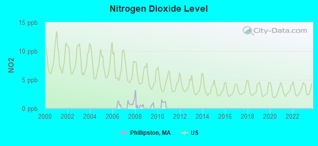
Nitrogen Dioxide (NO2) [ppb] level in 2007 was 1.02. This is significantly better than average. Closest monitor was 4.9 miles away from the city center.
| City: | 1.02 |
| U.S.: | 5.11 |
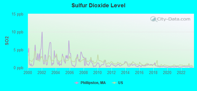
Sulfur Dioxide (SO2) [ppb] level in 2022 was 0.283. This is significantly better than average. Closest monitor was 4.9 miles away from the city center.
| City: | 0.283 |
| U.S.: | 1.515 |
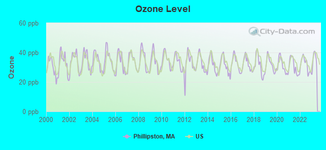
Ozone [ppb] level in 2022 was 31.7. This is about average. Closest monitor was 18.0 miles away from the city center.
| City: | 31.7 |
| U.S.: | 33.3 |
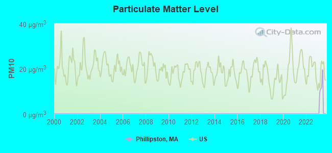
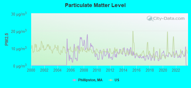
Particulate Matter (PM2.5) [µg/m3] level in 2022 was 6.14. This is better than average. Closest monitor was 18.0 miles away from the city center.
| City: | 6.14 |
| U.S.: | 8.11 |
Tornado activity:
Phillipston-area historical tornado activity is above Massachusetts state average. It is 13% smaller than the overall U.S. average.
On 6/9/1953, a category F4 (max. wind speeds 207-260 mph) tornado 6.8 miles away from the Phillipston town center killed 90 people and injured 1228 people and caused between $50,000,000 and $500,000,000 in damages.
On 6/22/1981, a category F3 (max. wind speeds 158-206 mph) tornado 7.2 miles away from the town center injured 3 people and caused between $5000 and $50,000 in damages.
Earthquake activity:
Phillipston-area historical earthquake activity is significantly above Massachusetts state average. It is 70% smaller than the overall U.S. average.On 10/7/1983 at 10:18:46, a magnitude 5.3 (5.1 MB, 5.3 LG, 5.1 ML, Class: Moderate, Intensity: VI - VII) earthquake occurred 146.6 miles away from the city center
On 4/20/2002 at 10:50:47, a magnitude 5.3 (5.3 ML, Depth: 3.0 mi) earthquake occurred 155.6 miles away from the city center
On 4/20/2002 at 10:50:47, a magnitude 5.2 (5.2 MB, 4.2 MS, 5.2 MW, 5.0 MW) earthquake occurred 154.6 miles away from Phillipston center
On 1/19/1982 at 00:14:42, a magnitude 4.7 (4.5 MB, 4.7 MD, 4.5 LG, Class: Light, Intensity: IV - V) earthquake occurred 70.1 miles away from the city center
On 10/16/2012 at 23:12:25, a magnitude 4.7 (4.7 ML, Depth: 10.0 mi) earthquake occurred 103.5 miles away from the city center
On 10/2/1994 at 11:27:22, a magnitude 3.7 (3.5 LG, 3.7 LG, Depth: 6.2 mi, Class: Light, Intensity: II - III) earthquake occurred 16.7 miles away from Phillipston center
Magnitude types: regional Lg-wave magnitude (LG), body-wave magnitude (MB), duration magnitude (MD), local magnitude (ML), surface-wave magnitude (MS), moment magnitude (MW)
Natural disasters:
The number of natural disasters in Worcester County (27) is a lot greater than the US average (15).Major Disasters (Presidential) Declared: 15
Emergencies Declared: 12
Causes of natural disasters: Floods: 9, Storms: 8, Hurricanes: 6, Snowstorms: 5, Winter Storms: 4, Blizzards: 2, Snows: 2, Fire: 1, Heavy Rain: 1, Snowfall: 1, Tornado: 1, Wind: 1 (Note: some incidents may be assigned to more than one category).
Hospitals and medical centers near Phillipston:
- TEMPLETON DEVELOPMENTAL CENTER (Hospital, about 3 miles away; BALDWINVILLE, MA)
- ATHOL MEMORIAL HOSPITAL Critical Access Hospitals (about 4 miles away; ATHOL, MA)
- ATHOL MEMORIAL HOME HEALTH AND HOSPICE (Hospital, about 6 miles away; ATHOL, MA)
- BALDWINVILLE NURSING HOME (Nursing Home, about 6 miles away; BALDWINVILLE, MA)
- QUABBIN VALLEY HEALTHCARE (Nursing Home, about 7 miles away; ATHOL, MA)
- HEYWOOD HOSPITAL Acute Care Hospitals (about 8 miles away; GARDNER, MA)
- GARDNER MANOR (Nursing Home, about 8 miles away; GARDNER, MA)
Colleges/universities with over 2000 students nearest to Phillipston:
- Mount Wachusett Community College (about 9 miles; Gardner, MA; Full-time enrollment: 3,143)
- Franklin Pierce University (about 16 miles; Rindge, NH; FT enrollment: 2,139)
- Fitchburg State University (about 18 miles; Fitchburg, MA; FT enrollment: 5,010)
- University of Massachusetts-Amherst (about 24 miles; Amherst, MA; FT enrollment: 26,583)
- Assumption College (about 25 miles; Worcester, MA; FT enrollment: 2,580)
- Quinsigamond Community College (about 25 miles; Worcester, MA; FT enrollment: 5,877)
- Worcester State University (about 26 miles; Worcester, MA; FT enrollment: 5,426)
Public elementary/middle school in Phillipston:
- PHILLIPSTON MEMORIAL (Students: 180, Location: 20 THE COMMON, Grades: PK-4)
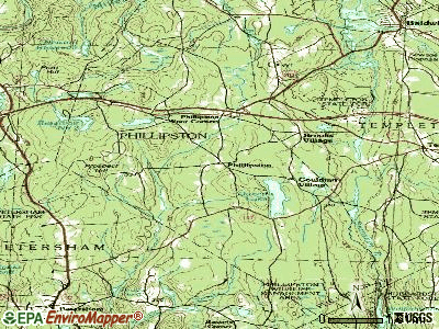
Points of interest:
Notable locations in Phillipston: Red Apple Farm (A), Phillipston Fire Department (B), Phillips Free Public Library (C). Display/hide their locations on the map
Church in Phillipston: Phillipston Congregational Church (A). Display/hide its location on the map
Cemeteries: South Cemetery (1), Lower Cemetery (2). Display/hide their locations on the map
Reservoirs and swamps: Queen Lake (A), Reservoir Number Two (B), Phillipston Reservoir (C), Bates Powers Reservoir (D), Thousand Acre Swamp (E). Display/hide their locations on the map
Streams, rivers, and creeks: Wine Brook (A), Bigelow Brook (B), Chickering Brook (C), Dunn Brook (D), Hoyt Brook (E), Kendall Brook (F), Lamb City Brook (G), Popple Camp Brook (H), Shattuck Brook (I). Display/hide their locations on the map
| This town: | 2.7 people |
| Massachusetts: | 2.5 people |
| This town: | 75.4% |
| Whole state: | 63.0% |
| This town: | 8.8% |
| Whole state: | 7.0% |
Likely homosexual households (counted as self-reported same-sex unmarried-partner households)
- Lesbian couples: 0.8% of all households
- Gay men: 0.2% of all households
| This town: | 5.8% |
| Whole state: | 9.3% |
| This town: | 2.5% |
| Whole state: | 4.4% |
For population 15 years and over in Phillipston:
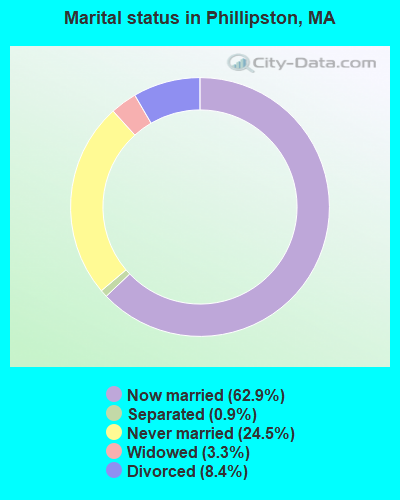
- Never married: 24.5%
- Now married: 62.9%
- Separated: 0.9%
- Widowed: 3.3%
- Divorced: 8.4%
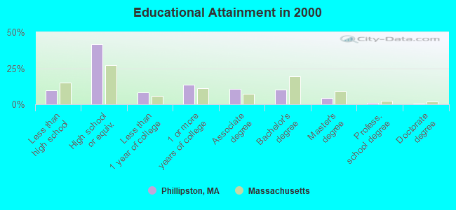
For population 25 years and over in Phillipston:
- High school or higher: 90.1%
- Bachelor's degree or higher: 16.2%
- Graduate or professional degree: 6.1%
- Unemployed: 3.0%
- Mean travel time to work (commute): 29.4 minutes
| Here: | 8.9 |
| Massachusetts average: | 13.1 |


Graphs represent county-level data. Detailed 2008 Election Results
Religion statistics for Phillipston, MA (based on Worcester County data)


| Religion | Adherents | Congregations |
|---|---|---|
| Catholic | 306,925 | 118 |
| Mainline Protestant | 43,326 | 171 |
| Evangelical Protestant | 37,511 | 203 |
| Other | 18,931 | 69 |
| Orthodox | 7,935 | 15 |
| Black Protestant | 497 | 6 |
| None | 383,427 | - |
Food Environment Statistics:
| This county: | 1.73 / 10,000 pop. |
| Massachusetts: | 1.98 / 10,000 pop. |
| This county: | 0.05 / 10,000 pop. |
| State: | 0.05 / 10,000 pop. |
| Here: | 1.79 / 10,000 pop. |
| Massachusetts: | 2.22 / 10,000 pop. |
| This county: | 2.22 / 10,000 pop. |
| State: | 1.77 / 10,000 pop. |
| This county: | 7.27 / 10,000 pop. |
| State: | 8.76 / 10,000 pop. |
| Worcester County: | 8.0% |
| Massachusetts: | 8.1% |
| This county: | 24.0% |
| Massachusetts: | 22.5% |
| Worcester County: | 16.6% |
| Massachusetts: | 16.5% |
4.71% of this county's 2021 resident taxpayers lived in other counties in 2020 ($76,229 average adjusted gross income)
| Here: | 4.71% |
| Massachusetts average: | 6.35% |
0.02% of residents moved from foreign countries ($100 average AGI)
Worcester County: 0.02% Massachusetts average: 0.01%
Top counties from which taxpayers relocated into this county between 2020 and 2021:
| from Middlesex County, MA | |
| from Norfolk County, MA | |
| from Suffolk County, MA |
4.84% of this county's 2020 resident taxpayers moved to other counties in 2021 ($87,252 average adjusted gross income)
| Here: | 4.84% |
| Massachusetts average: | 7.18% |
0.03% of residents moved to foreign countries ($199 average AGI)
Worcester County: 0.03% Massachusetts average: 0.02%
Top counties to which taxpayers relocated from this county between 2020 and 2021:
| to Middlesex County, MA | |
| to Norfolk County, MA | |
| to Suffolk County, MA |
Businesses in Phillipston, MA
- U-Haul: 1
Strongest AM radio stations in Phillipston:
- WCRN (830 AM; 50 kW; WORCESTER, MA; Owner: CARTER BROADCASTING CORPORATION)
- WVNE (760 AM; daytime; 25 kW; LEICESTER, MA; Owner: BLOUNT MASSCOM, INC.)
- WCAT (700 AM; daytime; 2 kW; ORANGE-ATHOL, MA; Owner: CITADEL BROADCASTING COMPANY)
- WNNZ (640 AM; 50 kW; WESTFIELD, MA; Owner: CLEAR CHANNEL BROADCASTING LICENSES, INC.)
- WRKO (680 AM; 50 kW; BOSTON, MA; Owner: ENTERCOM BOSTON LICENSE, LLC)
- WKOX (1200 AM; 50 kW; FRAMINGHAM, MA; Owner: CAPSTAR TX LIMITED PARTNERSHIP)
- WEEI (850 AM; 50 kW; BOSTON, MA; Owner: ENTERCOM BOSTON LICENSE, LLC)
- WBIX (1060 AM; 40 kW; NATICK, MA; Owner: LANGER BROADCASTING CORPORATION)
- WALE (990 AM; 50 kW; GREENVILLE, RI; Owner: NORTH AMERICAN BROADCASTING CO., INC.)
- WEIM (1280 AM; 5 kW; FITCHBURG, MA; Owner: LIVEAIR COMMUNICATIONS, INC.)
- WTAG (580 AM; 5 kW; WORCESTER, MA; Owner: CAPSTAR TX LIMITED PARTNERSHIP)
- WAMG (890 AM; 25 kW; DEDHAM, MA; Owner: MEGA COMMUNICATIONS OF DEDHAM LICENSEE, LLC)
- WWZN (1510 AM; 50 kW; BOSTON, MA; Owner: ROSE CITY RADIO CORPORATION)
Strongest FM radio stations in Phillipston:
- WAHL (99.9 FM; ATHOL, MA; Owner: CITADEL BROADCASTING COMPANY)
- WFEX (92.1 FM; PETERBOROUGH, NH; Owner: FNX BROADCASTING OF NEW HAMPSHIRE LLC)
- WINQ (97.7 FM; WINCHENDON, MA; Owner: SAGA COMMUNICATIONS OF NEW ENGLAND, LLC)
- WAAF (107.3 FM; WORCESTER, MA; Owner: ENTERCOM BOSTON LICENSE, LLC)
- WFCR (88.5 FM; AMHERST, MA; Owner: UNIVERSITY OF MASSACHUSETTS)
- WXLO (104.5 FM; FITCHBURG, MA; Owner: CITADEL BROADCASTING COMPANY)
- WSRS (96.1 FM; WORCESTER, MA; Owner: CAPSTAR TX LIMITED PARTNERSHIP)
- WAMH (89.3 FM; AMHERST, MA; Owner: TRUSTEES OF AMHERST COLLEGE)
- WJDF (97.3 FM; ORANGE, MA; Owner: DEANE BROTHERS BROADCASTING CORP.)
- WYRY (104.9 FM; HINSDALE, NH; Owner: TRI-VALLEY BROADCASTING CORPORATION)
- WPVQ (95.3 FM; GREENFIELD, MA; Owner: GREAT NORTHERN RADIO, L.L.C.)
- WHDQ (106.1 FM; CLAREMONT, NH; Owner: GREAT NORTHERN RADIO, L.L.C.)
- WAMC-FM (90.3 FM; ALBANY, NY; Owner: WAMC)
- WOQL (98.7 FM; WINCHESTER, NH; Owner: SAGA COMMUNICATIONS OF NEW HAMPSHIRE, LLC)
- WEQX (102.7 FM; MANCHESTER, VT; Owner: NORTHSHIRE COMMUNICATIONS, INC.)
- WJAN (95.1 FM; SUNDERLAND, VT; Owner: 6 JOHNSON ROAD LICENSES, INC.)
- W246AM (97.1 FM; AMHERST, MA; Owner: GREAT NORTHERN RADIO, LLC)
- WHYN-FM (93.1 FM; SPRINGFIELD, MA; Owner: CLEAR CHANNEL BROADCASTING LICENSES, INC.)
- WKNE (103.7 FM; KEENE, NH; Owner: SAGA COMMUNICATIONS OF NEW ENGLAND, LLC)
- WVPR (89.5 FM; WINDSOR, VT; Owner: VERMONT PUBLIC RADIO)
TV broadcast stations around Phillipston:
- WUNI (Channel 27; WORCESTER, MA; Owner: ENTRAVISION HOLDINGS, LLC)
- WYDN (Channel 48; WORCESTER, MA; Owner: EDUCATIONAL PUBLIC TV CORPORATION)
- WUTF (Channel 66; MARLBOROUGH, MA; Owner: TELEFUTURA BOSTON LLC)
- WCVB-TV (Channel 5; BOSTON, MA; Owner: WCVB HEARST-ARGYLE TV, INC.)
- WMFP (Channel 62; LAWRENCE, MA; Owner: WSAH LICENSE, INC.)
- WBZ-TV (Channel 4; BOSTON, MA; Owner: VIACOM INC.)
- WGBX-TV (Channel 44; BOSTON, MA; Owner: WGBH EDUCATIONAL FOUNDATION)
- WSBK-TV (Channel 38; BOSTON, MA; Owner: VIACOM INC.)
- WLVI-TV (Channel 56; CAMBRIDGE, MA; Owner: WLVI, INC.)
- Phillipston, Massachusetts
- Fatal accident count16
- Vehicles involved in fatal accidents28
- Fatal accidents involving drunk persons:5
- Fatalities22
- Persons involved in fatal accidents50
- Pedestrians involved in fatal accidents1
- Massachusetts average
- Fatal accident count6017
- Vehicles involved in fatal accidents8790
- Fatal accidents involving drunk persons1833
- Fatalities6415
- Persons involved in fatal accidents13465
- Pedestrians involved in fatal accidents1284
- National Bridge Inventory (NBI) Statistics
- 6Number of bridges
- 46ft / 13.7mTotal length
- $6,204,000Total costs
- 70,155Total average daily traffic
- 5,855Total average daily truck traffic
FCC Registered Antenna Towers:
13 (See the full list of FCC Registered Antenna Towers in Phillipston)FCC Registered Broadcast Land Mobile Towers:
1- Prospect Hill Fire Tower (Lat: 42.544444 Lon: -72.171944), Type: Ltower, Structure height: 20.7 m, Overall height: 30 m, Call Sign: WQAV611,
Assigned Frequencies: 461.937 MHz, Grant Date: 07/17/2014, Expiration Date: 08/16/2024, Certifier: Adrian Fabos, Registrant: D & R Communications, LLC, 15 Gore Road, Webster, MA 01570, Phone: (508) 943-9595, Fax: (508) 943-2676, Email:
FCC Registered Amateur Radio Licenses:
8 (See the full list of FCC Registered Amateur Radio Licenses in Phillipston)2002 - 2018 National Fire Incident Reporting System (NFIRS) incidents
- Fire incident types reported to NFIRS in Phillipston, MA
- 3634.6%Other
- 3028.8%Outside Fires
- 2625.0%Structure Fires
- 1211.5%Mobile Property/Vehicle Fires
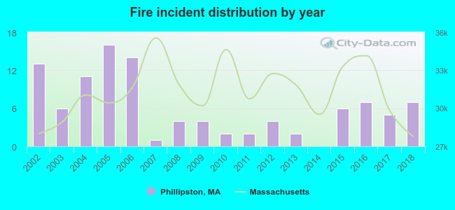 Based on the data from the years 2002 - 2018 the average number of fires per year is 6. The highest number of fire incidents - 16 took place in 2005, and the least - 0 in 2014. The data has a dropping trend.
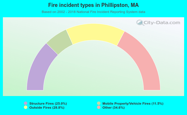 When looking into fire subcategories, the most reports belonged to: Other (34.6%), and Outside Fires (28.8%).
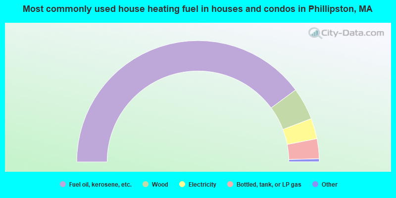
- 79.8%Fuel oil, kerosene, etc.
- 8.6%Wood
- 5.5%Electricity
- 5.3%Bottled, tank, or LP gas
- 0.4%Utility gas
- 0.4%Other fuel
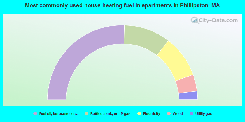
- 50.9%Fuel oil, kerosene, etc.
- 20.0%Bottled, tank, or LP gas
- 18.2%Electricity
- 7.3%Wood
- 3.6%Utility gas
Phillipston compared to Massachusetts state average:
- Median house value below state average.
- Unemployed percentage significantly below state average.
- Black race population percentage significantly below state average.
- Hispanic race population percentage significantly below state average.
- Foreign-born population percentage significantly below state average.
- Renting percentage significantly below state average.
- Length of stay since moving in significantly above state average.
- Number of rooms per house significantly below state average.
- House age significantly below state average.
- Number of college students below state average.
- Percentage of population with a bachelor's degree or higher below state average.

|
Total of 11 patent applications in 2008-2024.