Portage Lake, Maine

Portage Lake: tenderness
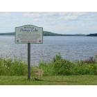
Portage Lake: Portage Lake public beach

Portage Lake: flyfishing in Deboullie
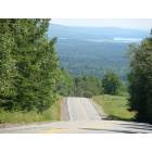
Portage Lake: Portage Lake from atop of Soucy Hill

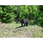
Portage Lake: his majesty
Portage Lake: Portage neighbors

Portage Lake: Portage Lake Sunset
Portage Lake: Portage neighbors

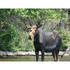
Portage Lake: Portage neighbors having lunch
- add
your
Submit your own pictures of this town and show them to the world
- OSM Map
- Google Map
- MSN Map
Population change since 2000: +0.3%
 |
| Males: 197 | |
| Females: 194 |
| Median resident age: | 56.2 years |
| Maine median age: | 43.0 years |
Zip codes: 04768.
| Portage Lake: | $57,446 |
| ME: | $69,543 |
Estimated per capita income in 2022: $37,113 (it was $17,983 in 2000)
Portage Lake town income, earnings, and wages data
Estimated median house or condo value in 2022: $173,602 (it was $71,700 in 2000)
| Portage Lake: | $173,602 |
| ME: | $290,600 |
Mean prices in 2022: all housing units: $179,108; detached houses: $185,023; townhouses or other attached units: $218,327; in 2-unit structures: $262,505; in 3-to-4-unit structures: $121,406; in 5-or-more-unit structures: $185,084; mobile homes: $117,009; occupied boats, rvs, vans, etc.: $12,682
Detailed information about poverty and poor residents in Portage Lake, ME


- 37595.9%White alone
- 112.8%Two or more races
- 41.0%American Indian alone
- 10.3%Black alone

Races in Portage Lake detailed stats: ancestries, foreign born residents, place of birth
 Recent articles from our blog. Our writers, many of them Ph.D. graduates or candidates, create easy-to-read articles on a wide variety of topics.
Ancestries: French (37.2%), English (20.0%), French Canadian (10.8%), Irish (8.5%), United States (6.4%), Scottish (3.6%).
Current Local Time: EST time zone
Incorporated on 03/24/1909
Land area: 30.7 square miles.
Population density: 13 people per square mile (very low).
21 residents are foreign born (5.4% North America).
| This town: | 5.4% |
| Maine: | 2.9% |
| Portage Lake town: | 1.0% ($742) |
| Maine: | 1.5% ($1,417) |
Nearest city with pop. 50,000+: Portland, ME  (231.9 miles , pop. 64,249).
Nearest city with pop. 200,000+: Boston, MA (333.6 miles , pop. 589,141).
Nearest city with pop. 1,000,000+: Bronx, NY (489.9 miles , pop. 1,332,650).
Nearest cities:
), ), ), ), Latitude: 46.78 N, Longitude: 68.50 W
Area code commonly used in this area: 207

Single-family new house construction building permits:
- 2022: 3 buildings, average cost: $72,000
- 2020: 5 buildings, average cost: $94,000
- 2019: 2 buildings, average cost: $52,000
- 2018: 7 buildings, average cost: $47,900
- 2017: 1 building, cost: $49,000
- 2016: 1 building, cost: $150,000
- 2015: 3 buildings, average cost: $113,300
- 2014: 1 building, cost: $60,000
- 2013: 3 buildings, average cost: $168,300
- 2012: 1 building, cost: $175,000
- 2011: 2 buildings, average cost: $55,000
- 2010: 2 buildings, average cost: $80,000
- 2009: 3 buildings, average cost: $121,700
- 2007: 5 buildings, average cost: $103,300
- 2006: 6 buildings, average cost: $103,300
- 2005: 3 buildings, average cost: $51,000
- 2004: 3 buildings, average cost: $51,000
- 2003: 5 buildings, average cost: $69,000
- 2002: 2 buildings, average cost: $75,000
- 2001: 8 buildings, average cost: $46,400
- 2000: 1 building, cost: $30,000
- 1999: 1 building, cost: $30,000
- 1998: 3 buildings, average cost: $61,700
- 1997: 1 building, cost: $15,000


| Here: | 10.9% |
| Maine: | 3.4% |


- Wood products (29.7%)
- Agriculture, forestry, fishing & hunting (12.8%)
- Educational services (7.0%)
- Health care (5.2%)
- Accommodation & food services (5.2%)
- Construction (4.7%)
- Food & beverage stores (4.1%)

- Wood products (41.4%)
- Agriculture, forestry, fishing & hunting (17.2%)
- Construction (8.1%)
- Truck transportation (7.1%)
- Lumber & other construction materials merchant wholesalers (3.0%)
- Textile mills & textile products (3.0%)
- Motor vehicle & parts dealers (2.0%)

- Wood products (13.7%)
- Educational services (13.7%)
- Health care (12.3%)
- Food & beverage stores (9.6%)
- Accommodation & food services (9.6%)
- Agriculture, forestry, fishing & hunting (6.8%)
- Social assistance (6.8%)

- Other production occupations, including supervisors (7.0%)
- Driver/sales workers and truck drivers (6.4%)
- Other management occupations, except farmers and farm managers (5.2%)
- Electrical equipment mechanics and other installation, maintenance, and repair workers, including supervisors (5.2%)
- Other material moving workers, except laborers (5.2%)
- Construction traders workers except carpenters, electricians, painters, plumbers, and construction laborers (5.2%)
- Material recording, scheduling, dispatching, and distributing workers (4.7%)

- Other production occupations, including supervisors (12.1%)
- Driver/sales workers and truck drivers (11.1%)
- Electrical equipment mechanics and other installation, maintenance, and repair workers, including supervisors (9.1%)
- Construction traders workers except carpenters, electricians, painters, plumbers, and construction laborers (9.1%)
- Other material moving workers, except laborers (7.1%)
- Other management occupations, except farmers and farm managers (5.1%)
- Top executives (4.0%)

- Preschool, kindergarten, elementary, and middle school teachers (9.6%)
- Cashiers (9.6%)
- Other office and administrative support workers, including supervisors (9.6%)
- Registered nurses (8.2%)
- Waiters and waitresses (6.8%)
- Other teachers, instructors, education, training, and library occupations (6.8%)
- Material recording, scheduling, dispatching, and distributing workers (6.8%)
Average climate in Portage Lake, Maine
Based on data reported by over 4,000 weather stations


(lower is better)

Air Quality Index (AQI) level in 2023 was 79.3. This is about average.
| City: | 79.3 |
| U.S.: | 72.6 |

Carbon Monoxide (CO) [ppm] level in 2021 was 0.155. This is significantly better than average. Closest monitor was 22.8 miles away from the city center.
| City: | 0.155 |
| U.S.: | 0.251 |

Nitrogen Dioxide (NO2) [ppb] level in 2022 was 1.41. This is significantly better than average. Closest monitor was 22.8 miles away from the city center.
| City: | 1.41 |
| U.S.: | 5.11 |

Sulfur Dioxide (SO2) [ppb] level in 2022 was 0.0234. This is significantly better than average. Closest monitor was 22.8 miles away from the city center.
| City: | 0.0234 |
| U.S.: | 1.5147 |

Ozone [ppb] level in 2022 was 28.0. This is about average. Closest monitor was 12.7 miles away from the city center.
| City: | 28.0 |
| U.S.: | 33.3 |

Particulate Matter (PM10) [µg/m3] level in 2023 was 19.0. This is about average. Closest monitor was 11.3 miles away from the city center.
| City: | 19.0 |
| U.S.: | 19.2 |

Particulate Matter (PM2.5) [µg/m3] level in 2023 was 6.40. This is better than average. Closest monitor was 22.5 miles away from the city center.
| City: | 6.40 |
| U.S.: | 8.11 |
Earthquake activity:
Portage Lake-area historical earthquake activity is above Maine state average. It is 86% smaller than the overall U.S. average.On 7/14/2006 at 09:34:48, a magnitude 3.9 (3.9 MD, Depth: 8.6 mi, Class: Light, Intensity: II - III) earthquake occurred 11.1 miles away from the city center
On 4/20/2002 at 10:50:47, a magnitude 5.3 (5.3 ML, Depth: 3.0 mi, Class: Moderate, Intensity: VI - VII) earthquake occurred 296.1 miles away from the city center
On 4/20/2002 at 10:50:47, a magnitude 5.2 (5.2 MB, 4.2 MS, 5.2 MW, 5.0 MW) earthquake occurred 297.9 miles away from the city center
On 10/7/1983 at 10:18:46, a magnitude 5.3 (5.1 MB, 5.3 LG, 5.1 ML) earthquake occurred 344.5 miles away from Portage Lake center
On 10/16/2012 at 23:12:25, a magnitude 4.7 (4.7 ML, Depth: 10.0 mi, Class: Light, Intensity: IV - V) earthquake occurred 243.8 miles away from the city center
On 1/19/1982 at 00:14:42, a magnitude 4.7 (4.5 MB, 4.7 MD, 4.5 LG) earthquake occurred 272.5 miles away from the city center
Magnitude types: regional Lg-wave magnitude (LG), body-wave magnitude (MB), duration magnitude (MD), local magnitude (ML), surface-wave magnitude (MS), moment magnitude (MW)
Natural disasters:
The number of natural disasters in Aroostook County (22) is greater than the US average (15).Major Disasters (Presidential) Declared: 13
Emergencies Declared: 9
Causes of natural disasters: Floods: 10, Storms: 8, Snows: 7, Heavy Rains: 2, Blizzard: 1, Hurricane: 1, Ice Storm: 1, Snowfall: 1, Snowstorm: 1, Wind: 1, Winter Storm: 1, Other: 2 (Note: some incidents may be assigned to more than one category).
located in Portage Lake:
See details about located in Portage Lake, MEColleges/universities with over 2000 students nearest to Portage Lake:
- University of Maine (about 131 miles; Orono, ME; Full-time enrollment: 8,931)
- Husson University (about 136 miles; Bangor, ME; FT enrollment: 2,421)
- University of Maine at Farmington (about 167 miles; Farmington, ME; FT enrollment: 2,036)
- University of Maine at Augusta (about 181 miles; Augusta, ME; FT enrollment: 3,204)
- Saint Joseph's College of Maine (about 226 miles; Standish, ME; FT enrollment: 2,010)
- University of Southern Maine (about 233 miles; Portland, ME; FT enrollment: 6,647)
- Southern Maine Community College (about 233 miles; South Portland, ME; FT enrollment: 4,666)
Points of interest:
Notable locations in Portage Lake: Bolstridge Camp (A), Portage Lake Volunteer Fire Department (B). Display/hide their locations on the map
Cemeteries: Sutherland Cemetery (1), Our Lady of the Lake Catholic Cemetery (2), Goodblood Cemetery (3), Buffalo Cemetery (4). Display/hide their locations on the map
Lake: Portage Lake (A). Display/hide its location on the map
Streams, rivers, and creeks: Mosquito Brook (A). Display/hide its location on the map
Drinking water stations with addresses in Portage Lake and their reported violations in the past:
MAINE WOODS COMPANY LLC (Population served: 60, Groundwater):Past health violations:Past monitoring violations:
- MCL, Monthly (TCR) - In DEC-2013, Contaminant: Coliform. Follow-up actions: St Public Notif requested (DEC-16-2013), St Formal NOV issued (DEC-16-2013), St Public Notif received (DEC-20-2013)
- Follow-up Or Routine LCR Tap M/R - In OCT-01-2006, Contaminant: Lead and Copper Rule. Follow-up actions: St Public Notif received (DEC-11-2006), St Public Notif requested (FEB-20-2007), St Violation/Reminder Notice (FEB-20-2007), St Compliance achieved (MAR-12-2008)
- 10 routine major monitoring violations
- 14 regular monitoring violations
| This town: | 2.1 people |
| Maine: | 2.3 people |
| This town: | 65.4% |
| Whole state: | 62.9% |
| This town: | 9.6% |
| Whole state: | 9.4% |
No gay or lesbian households reported
| This town: | 9.8% |
| Whole state: | 10.9% |
| This town: | 3.9% |
| Whole state: | 4.1% |
For population 15 years and over in Portage Lake:

- Never married: 18.3%
- Now married: 64.6%
- Separated: 0.0%
- Widowed: 8.5%
- Divorced: 8.5%
For population 25 years and over in Portage Lake:
- High school or higher: 72.9%
- Bachelor's degree or higher: 14.1%
- Graduate or professional degree: 4.9%
- Unemployed: 6.0%
- Mean travel time to work (commute): 25.9 minutes


| Here: | 13.2 |
| Maine average: | 11.2 |


Graphs represent county-level data. Detailed 2008 Election Results
Religion statistics for Portage Lake, ME (based on Aroostook County data)


| Religion | Adherents | Congregations |
|---|---|---|
| Catholic | 22,200 | 27 |
| Mainline Protestant | 5,845 | 40 |
| Evangelical Protestant | 4,411 | 51 |
| Other | 957 | 7 |
| Orthodox | 10 | 1 |
| None | 38,447 | - |
Food Environment Statistics:
| Aroostook County: | 4.03 / 10,000 pop. |
| Maine: | 2.80 / 10,000 pop. |
| Aroostook County: | 0.14 / 10,000 pop. |
| State: | 0.14 / 10,000 pop. |
| This county: | 2.22 / 10,000 pop. |
| State: | 2.20 / 10,000 pop. |
| Here: | 7.78 / 10,000 pop. |
| Maine: | 5.75 / 10,000 pop. |
| Aroostook County: | 9.17 / 10,000 pop. |
| State: | 11.02 / 10,000 pop. |
| Aroostook County: | 11.7% |
| Maine: | 8.2% |
| Aroostook County: | 27.6% |
| Maine: | 25.0% |
Strongest AM radio stations in Portage Lake:
- WFST (600 AM; 5 kW; CARIBOU, ME; Owner: NORTHERN BROADCAST MINISTRIES, INC.)
- WEGP (1390 AM; 5 kW; PRESQUE ISLE, ME; Owner: DECELLES/SMITH MEDIA, INC.)
- WREM (710 AM; daytime; 5 kW; MONTICELLO, ME; Owner: ALLAN H WEINER)
- WRKO (680 AM; 50 kW; BOSTON, MA; Owner: ENTERCOM BOSTON LICENSE, LLC)
- WCHP (760 AM; 35 kW; CHAMPLAIN, NY; Owner: CHAMPLAIN RADIO, INC.)
- WNNZ (640 AM; 50 kW; WESTFIELD, MA; Owner: CLEAR CHANNEL BROADCASTING LICENSES, INC.)
- WEEI (850 AM; 50 kW; BOSTON, MA; Owner: ENTERCOM BOSTON LICENSE, LLC)
- WCRN (830 AM; 50 kW; WORCESTER, MA; Owner: CARTER BROADCASTING CORPORATION)
- WBZ (1030 AM; 50 kW; BOSTON, MA; Owner: INFINITY BROADCASTING OPERATIONS, INC.)
- WZON (620 AM; 5 kW; BANGOR, ME; Owner: THE ZONE CORPORATION)
- WGY (810 AM; 50 kW; SCHENECTADY, NY; Owner: CLEAR CHANNEL BROADCASTING LICENSES, INC.)
- WSKW (1160 AM; 10 kW; SKOWHEGAN, ME; Owner: MOUNTAIN WIRELESS, INCORPORATED)
- WICY (1490 AM; 50 kW; MALONE, NY; Owner: CARTIER COMMUNICATIONS INC.)
Strongest FM radio stations in Portage Lake:
- WBPW (96.9 FM; PRESQUE ISLE, ME; Owner: CITADEL BROADCASTING COMPANY)
- WQHR (96.1 FM; PRESQUE ISLE, ME; Owner: CITADEL BROADCASTING COMPANY)
- WOZI (101.9 FM; PRESQUE ISLE, ME; Owner: CITADEL BROADCASTING COMPANY)
- WMEM (106.1 FM; PRESQUE ISLE, ME; Owner: MAINE PUBLIC BROADCASTING CORPORATION)
- W274AF (102.7 FM; PRESQUE ISLE, ME; Owner: BANGOR BAPTIST CHURCH)
FCC Registered Broadcast Land Mobile Towers:
1- Golf Course Road (Lat: 46.766361 Lon: -68.474222), Type: Pole, Structure height: 3.5 m, Overall height: 11 m, Call Sign: KNHY347,
Assigned Frequencies: 155.955 MHz, Grant Date: 11/01/2023, Expiration Date: 12/02/2033, Registrant: Radio Communications Management, Inc, 158 Rand Rd, Portland, ME 04102, Phone: (207) 797-7503, Fax: (207) 587-3521, Email:

- 67.9%Fuel oil, kerosene, etc.
- 29.6%Wood
- 2.5%Bottled, tank, or LP gas

- 62.5%Fuel oil, kerosene, etc.
- 12.5%Bottled, tank, or LP gas
- 12.5%Electricity
- 12.5%Wood
Portage Lake compared to Maine state average:
- Median house value below state average.
- Unemployed percentage below state average.
- Black race population percentage significantly below state average.
- Hispanic race population percentage significantly below state average.
- Median age significantly above state average.
- Renting percentage significantly below state average.
- Length of stay since moving in significantly above state average.
- Number of rooms per house significantly below state average.
- House age significantly below state average.
- Percentage of population with a bachelor's degree or higher below state average.