Rantoul, Wisconsin
Submit your own pictures of this town and show them to the world
- OSM Map
- Google Map
- MSN Map
Population change since 2000: -5.1%
| Males: 416 | |
| Females: 382 |
| Median resident age: | 40.3 years |
| Wisconsin median age: | 42.6 years |
Zip codes: 54129.
| Rantoul: | $75,287 |
| WI: | $70,996 |
Estimated per capita income in 2022: $35,239 (it was $18,316 in 2000)
Rantoul town income, earnings, and wages data
Estimated median house or condo value in 2022: $260,366 (it was $110,200 in 2000)
| Rantoul: | $260,366 |
| WI: | $252,800 |
Mean prices in 2022: all housing units: $260,489; detached houses: $265,602; townhouses or other attached units: $176,278; in 2-unit structures: $508,640; in 3-to-4-unit structures: $278,880; in 5-or-more-unit structures: $121,263; mobile homes: $28,072
Detailed information about poverty and poor residents in Rantoul, WI
Compare current foreclosures near Rantoul, WI:
| Photo | Address | Area | Beds / Baths | Price | Details |
|---|---|---|---|---|---|

|
#1
Desnoyer St
Kaukauna, WI 54130
|
921 sq. feet
|
1 baths 2 beds |
show details | |

|
#2
W 12th St
Kaukauna, WI 54130
|
1,320 sq. feet
|
1 baths 3 beds |
show details | |

|
#3
E Kimberly Ave
Kimberly, WI 54136
|
2,628 sq. feet
|
3 baths 4 beds |
show details | |

|
#4
S Walnut St
Kimberly, WI 54136
|
1,124 sq. feet
|
1 baths 3 beds |
show details | |

|
#5
S Birch St
Kimberly, WI 54136
|
1,128 sq. feet
|
1 baths 2 beds |
show details | |

|
#6
Jefferson Pl
Kimberly, WI 54136
|
1,260 sq. feet
|
2 baths 3 beds |
show details | |

|
#7
George St
Kaukauna, WI 54130
|
1,440 sq. feet
|
2 baths 3 beds |
show details | |

|
#8
E 7th St
Kaukauna, WI 54130
|
2,547 sq. feet
|
2 baths 4 beds |
show details | |

|
#9
S Telulah Ave
Appleton, WI 54915
|
891 sq. feet
|
1 baths 3 beds |
show details | |

|
#10
Grassymeadow Ln
Menasha, WI 54952
|
1,370 sq. feet
|
2 baths 3 beds |
show details |
| Photo | Address | Area | Beds / Baths | Price | Details |
|---|---|---|---|---|---|

|
#11
S Irma St
Appleton, WI 54915
|
1,398 sq. feet
|
2 baths 3 beds |
show details | |

|
#12
E Cranberry Dr
Appleton, WI 54915
|
1,922 sq. feet
|
2 baths 3 beds |
show details | |

|
#13
Bittersweet Ct
Menasha, WI 54952
|
2,594 sq. feet
|
4 baths 4 beds |
show details | |

|
#14
Manitoba St
Menasha, WI 54952
|
1,692 sq. feet
|
2 baths 3 beds |
show details | |

|
#15
S Berry Dr
Appleton, WI 54915
|
1,600 sq. feet
|
1 baths 3 beds |
show details | |

|
#16
Jordan Ave
New Holstein, WI 53061
|
- sq. feet
|
- baths - beds |
show details | |

|
#17
Achievement Dr # C23
Brillion, WI 54110
|
- sq. feet
|
- baths - beds |
show details | |

|
#18
E Pollywog Way # 147
Appleton, WI 54915
|
- sq. feet
|
- baths - beds |
show details | |

|
#19
W 12th St Apt 4
Kaukauna, WI 54130
|
- sq. feet
|
- baths - beds |
show details | |

|
#20
County Road H
Chilton, WI 53014
|
- sq. feet
|
- baths - beds |
show details |
| Photo | Address | Area | Beds / Baths | Price | Details |
|---|---|---|---|---|---|

|
#21
County Rd E
Chilton, WI 53014
|
- sq. feet
|
- baths - beds |
show details | |

|
#22
Van Cops Dr
Kaukauna, WI 54130
|
- sq. feet
|
- baths - beds |
show details | |

|
#23
Kelso Road
Kaukauna, WI 54130
|
- sq. feet
|
- baths - beds |
show details | |

|
#24
Taylor St
Little Chute, WI 54140
|
- sq. feet
|
- baths - beds |
show details | |

|
#25
Tecumseh Rd
New Holstein, WI 53061
|
- sq. feet
|
- baths - beds |
show details | |

|
#26
Holstein Rd
Elkhart Lake, WI 53020
|
- sq. feet
|
- baths - beds |
show details | |

|
#27
Dundas Rd
Kaukauna, WI 54130
|
- sq. feet
|
- baths - beds |
show details | |

|
#28
Papermaker Pass
Menasha, WI 54952
|
- sq. feet
|
- baths - beds |
show details | |

|
#29
Jordan St
Appleton, WI 54915
|
- sq. feet
|
- baths - beds |
show details | |

|
#30
E 3rd St
Kimberly, WI 54136
|
- sq. feet
|
- baths - beds |
show details |
| Photo | Address | Area | Beds / Baths | Price | Details |
|---|---|---|---|---|---|

|
#31
N Coop Rd, Apt B
Appleton, WI 54915
|
- sq. feet
|
- baths - beds |
show details | |

|
#32
Stillmeadow Ln Apt 2
Menasha, WI 54952
|
- sq. feet
|
- baths - beds |
show details | |

|
#33
N Coop Rd, Apt B
Appleton, WI 54915
|
- sq. feet
|
- baths - beds |
show details | |

|
#34
Harvard Ct
Appleton, WI 54915
|
- sq. feet
|
- baths - beds |
show details | |

|
#35
Lamp Lighter Dr Apt 1
Kaukauna, WI 54130
|
- sq. feet
|
- baths - beds |
show details | |

|
#36
Hill Rd
Greenleaf, WI 54126
|
- sq. feet
|
- baths - beds |
show details | |

|
#37
Wisconsin Ave
New Holstein, WI 53061
|
- sq. feet
|
- baths - beds |
show details | |

|
#38
E Midway Rd, Apt 47
Appleton, WI 54915
|
- sq. feet
|
- baths - beds |
show details | |

|
#39
Springfield Dr
Appleton, WI 54915
|
- sq. feet
|
- baths - beds |
show details | |

|
#40
Janet Ln
Wrightstown, WI 54180
|
- sq. feet
|
- baths - beds |
show details |
| Photo | Address | Area | Beds / Baths | Price | Details |
|---|---|---|---|---|---|

|
#41
Country Ayre Ct
Appleton, WI 54915
|
- sq. feet
|
- baths - beds |
show details | |

|
#42
Pinecrest Blvd
Appleton, WI 54915
|
- sq. feet
|
- baths - beds |
show details | |

|
#43
Whitepine Dr
Appleton, WI 54915
|
- sq. feet
|
- baths - beds |
show details | |

|
#44
E Lake Park Xing Unit 36
Appleton, WI 54915
|
- sq. feet
|
- baths - beds |
show details | |

|
#45
Hickory St # 105
Wrightstown, WI 54180
|
- sq. feet
|
- baths - beds |
show details | |

|
#46
Sweet William Dr
Appleton, WI 54915
|
- sq. feet
|
- baths - beds |
show details | |

|
#47
E Lake Park Xing Unit 66
Appleton, WI 54915
|
- sq. feet
|
- baths - beds |
show details | |

|
#48
Hendricks Ave
Kaukauna, WI 54130
|
- sq. feet
|
- baths - beds |
show details | |

|
#49
S Schaefer St Apt 2
Appleton, WI 54915
|
- sq. feet
|
- baths - beds |
show details | |

|
Check over 1 million property listings on Foreclosure.com!
|
browse all offers | |||

- 76996.4%White alone
- 91.1%American Indian alone
- 70.9%Two or more races
- 60.8%Asian alone
- 50.6%Hispanic
- 20.3%Black alone

Races in Rantoul detailed stats: ancestries, foreign born residents, place of birth
 Recent articles from our blog. Our writers, many of them Ph.D. graduates or candidates, create easy-to-read articles on a wide variety of topics.
Ancestries: German (74.6%), Irish (7.3%), United States (6.7%), Polish (3.7%), English (3.4%), Norwegian (1.9%).
Current Local Time: CST time zone
Land area: 32.4 square miles.
Population density: 25 people per square mile (very low).
7 residents are foreign born
| This town: | 0.8% |
| Wisconsin: | 3.6% |
| Rantoul town: | 1.3% ($1,382) |
| Wisconsin: | 2.0% ($2,245) |
Nearest city with pop. 50,000+: Appleton, WI  (18.7 miles , pop. 70,087).
Nearest city with pop. 200,000+: Milwaukee, WI (73.3 miles , pop. 596,974).
Nearest city with pop. 1,000,000+: Chicago, IL (158.1 miles , pop. 2,896,016).
Nearest cities:
), ), ), ), )Latitude: 44.11 N, Longitude: 88.10 W
Area code commonly used in this area: 920

Single-family new house construction building permits:
- 2020: 2 buildings, average cost: $274,600
- 2019: 1 building, cost: $550,000
- 2018: 1 building, cost: $425,000
- 2017: 5 buildings, average cost: $263,300
- 2015: 2 buildings, average cost: $232,000
- 2014: 1 building, cost: $340,000
- 2013: 3 buildings, average cost: $195,500
- 2012: 2 buildings, average cost: $317,500


| Here: | 2.1% |
| Wisconsin: | 2.7% |

- Agriculture, forestry, fishing & hunting (19.9%)
- Machinery (12.1%)
- Metal & metal products (11.3%)
- Construction (7.7%)
- Health care (4.4%)
- Accommodation & food services (4.0%)
- Food (3.6%)

- Agriculture, forestry, fishing & hunting (23.0%)
- Metal & metal products (17.2%)
- Construction (13.7%)
- Machinery (13.3%)
- Paper (3.5%)
- Administrative & support & waste management services (2.7%)
- Food (2.3%)

- Agriculture, forestry, fishing & hunting (16.2%)
- Machinery (10.8%)
- Health care (9.0%)
- Accommodation & food services (8.1%)
- Finance & insurance (5.9%)
- Food (5.0%)
- Metal & metal products (4.5%)

- Farmers and farm managers (14.0%)
- Metal workers and plastic workers (7.9%)
- Other office and administrative support workers, including supervisors (5.9%)
- Agricultural workers, including supervisors (5.4%)
- Laborers and material movers, hand (4.8%)
- Other production occupations, including supervisors (4.8%)
- Other sales and related occupations, including supervisors (4.0%)

- Farmers and farm managers (16.4%)
- Metal workers and plastic workers (10.9%)
- Laborers and material movers, hand (8.2%)
- Agricultural workers, including supervisors (6.6%)
- Other production occupations, including supervisors (6.2%)
- Driver/sales workers and truck drivers (6.2%)
- Other sales and related occupations, including supervisors (3.5%)

- Other office and administrative support workers, including supervisors (11.7%)
- Farmers and farm managers (11.3%)
- Assemblers and fabricators (5.0%)
- Secretaries and administrative assistants (5.0%)
- Metal workers and plastic workers (4.5%)
- Other sales and related occupations, including supervisors (4.5%)
- Agricultural workers, including supervisors (4.1%)
Average climate in Rantoul, Wisconsin
Based on data reported by over 4,000 weather stations


(lower is better)

Air Quality Index (AQI) level in 2022 was 79.3. This is about average.
| City: | 79.3 |
| U.S.: | 72.6 |


Ozone [ppb] level in 2022 was 32.7. This is about average. Closest monitor was 6.6 miles away from the city center.
| City: | 32.7 |
| U.S.: | 33.3 |

Particulate Matter (PM2.5) [µg/m3] level in 2016 was 6.47. This is better than average. Closest monitor was 21.6 miles away from the city center.
| City: | 6.47 |
| U.S.: | 8.11 |

Lead (Pb) [µg/m3] level in 2002 was 0.00649. This is significantly better than average. Closest monitor was 17.9 miles away from the city center.
| City: | 0.00649 |
| U.S.: | 0.00931 |
Tornado activity:
Rantoul-area historical tornado activity is near Wisconsin state average. It is 14% greater than the overall U.S. average.
On 7/18/1996, a category F5 (max. wind speeds 261-318 mph) tornado 30.2 miles away from the Rantoul town center injured 12 people and caused $40 million in damages.
On 7/5/1994, a category F4 (max. wind speeds 207-260 mph) tornado 18.3 miles away from the town center injured 2 people and caused between $500,000 and $5,000,000 in damages.
Earthquake activity:
Rantoul-area historical earthquake activity is significantly above Wisconsin state average. It is 14% smaller than the overall U.S. average.On 4/18/2008 at 09:36:59, a magnitude 5.4 (5.1 MB, 4.8 MS, 5.4 MW, 5.2 MW, Class: Moderate, Intensity: VI - VII) earthquake occurred 391.2 miles away from Rantoul center
On 5/2/2015 at 16:23:07, a magnitude 4.2 (4.2 MW, Depth: 2.8 mi, Class: Light, Intensity: IV - V) earthquake occurred 186.7 miles away from the city center
On 6/28/2004 at 06:10:52, a magnitude 4.2 (4.2 MW, Depth: 6.2 mi) earthquake occurred 187.5 miles away from the city center
On 6/10/1987 at 23:48:54, a magnitude 5.1 (4.9 MB, 4.4 MS, 4.6 MS, 5.1 LG) earthquake occurred 365.7 miles away from Rantoul center
On 4/18/2008 at 09:36:59, a magnitude 5.2 (5.2 MW, Depth: 8.9 mi) earthquake occurred 391.3 miles away from Rantoul center
On 2/10/2010 at 09:59:35, a magnitude 3.8 (3.8 MW, Depth: 6.2 mi, Class: Light, Intensity: II - III) earthquake occurred 149.2 miles away from the city center
Magnitude types: regional Lg-wave magnitude (LG), body-wave magnitude (MB), surface-wave magnitude (MS), moment magnitude (MW)
Natural disasters:
The number of natural disasters in Calumet County (10) is smaller than the US average (15).Major Disasters (Presidential) Declared: 8
Emergencies Declared: 2
Causes of natural disasters: Floods: 7, Storms: 6, Tornadoes: 4, Drought: 1, Hurricane: 1, Wind: 1, Other: 1 (Note: some incidents may be assigned to more than one category).
Hospitals and medical centers near Rantoul:
- CALUMET MEDICAL CTR Critical Access Hospitals (about 7 miles away; CHILTON, WI)
- CHILTON CARE CTR (Nursing Home, about 7 miles away; CHILTON, WI)
- CHILTON VILLAGE (Nursing Home, about 7 miles away; CHILTON, WI)
- CALUMET HOMESTEAD (Nursing Home, about 12 miles away; NEW HOLSTEIN, WI)
- HOMESTEAD CARE CENTER, LLC (Nursing Home, about 12 miles away; NEW HOLSTEIN, WI)
- WILLOWDALE NURSING AND REHAB (Nursing Home, about 12 miles away; NEW HOLSTEIN, WI)
- ST PAUL ELDER SERVICES, INC (Nursing Home, about 15 miles away; KAUKAUNA, WI)
Colleges/universities with over 2000 students nearest to Rantoul:
- Lawrence University (about 19 miles; Appleton, WI; Full-time enrollment: 2,821)
- Lakeland College (about 22 miles; Plymouth, WI; FT enrollment: 2,395)
- Fox Valley Technical College (about 22 miles; Appleton, WI; FT enrollment: 5,682)
- University of Wisconsin-Oshkosh (about 24 miles; Oshkosh, WI; FT enrollment: 10,637)
- Saint Norbert College (about 24 miles; De Pere, WI; FT enrollment: 2,324)
- Moraine Park Technical College (about 28 miles; Fond du Lac, WI; FT enrollment: 3,079)
- Marian University (about 28 miles; Fond Du Lac, WI; FT enrollment: 2,045)
Points of interest:
Notable locations in Rantoul: Hilbert Wastewater Treatment Plant (A), Potter Volunteer Fire Department (B). Display/hide their locations on the map
Church in Rantoul: Peace United Church of Christ (A). Display/hide its location on the map
Cemeteries: Rantoul Cemetery (1), Trinity Lutheran Cemetery (2). Display/hide their locations on the map
Lakes: Round Lake (A), Becker Lake (B), Boot Lake (C), Grass Lake (D). Display/hide their locations on the map
Rivers and creeks: Spring Creek (A), North Branch Manitowoc River (B), South Branch Manitowoc River (C). Display/hide their locations on the map
Park in Rantoul: Brillion State Wildlife Area (1). Display/hide its location on the map
Birthplace of: Gervase Hephner - Politician.
| This town: | 2.9 people |
| Wisconsin: | 2.4 people |
| This town: | 85.3% |
| Whole state: | 64.4% |
| This town: | 5.1% |
| Whole state: | 7.3% |
Likely homosexual households (counted as self-reported same-sex unmarried-partner households)
- Lesbian couples: 0.0% of all households
- Gay men: 0.4% of all households
| This town: | 3.1% |
| Whole state: | 8.7% |
| This town: | 2.3% |
| Whole state: | 3.7% |
For population 15 years and over in Rantoul:

- Never married: 21.0%
- Now married: 70.5%
- Separated: 0.3%
- Widowed: 3.7%
- Divorced: 4.5%
For population 25 years and over in Rantoul:
- High school or higher: 84.5%
- Bachelor's degree or higher: 7.4%
- Graduate or professional degree: 0.7%
- Unemployed: 0.6%
- Mean travel time to work (commute): 22.2 minutes


| Here: | 7.5 |
| Wisconsin average: | 11.0 |
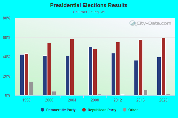
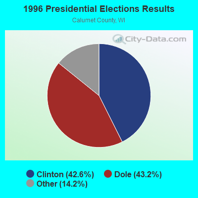
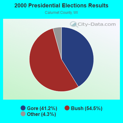
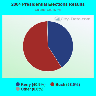
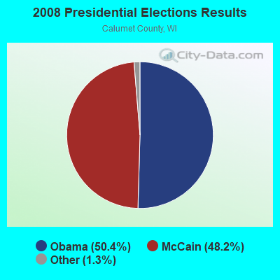
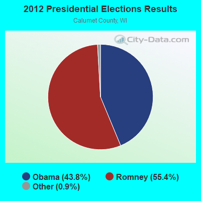
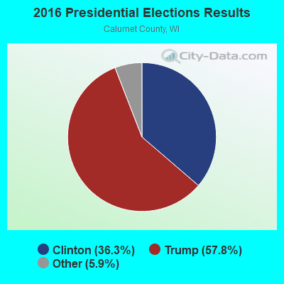
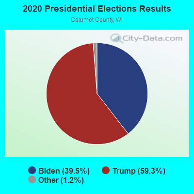
Graphs represent county-level data. Detailed 2008 Election Results
Religion statistics for Rantoul, WI (based on Calumet County data)
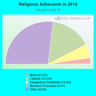
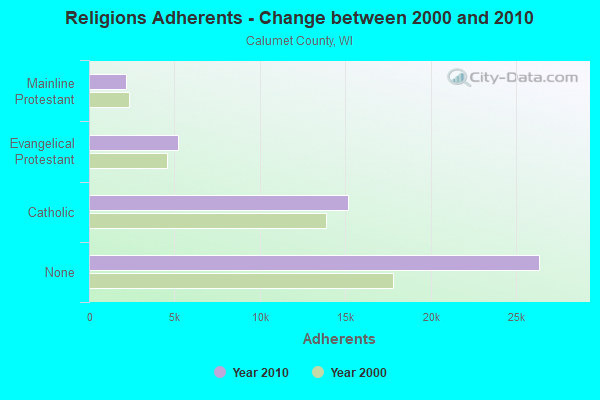
| Religion | Adherents | Congregations |
|---|---|---|
| Catholic | 15,168 | 7 |
| Evangelical Protestant | 5,208 | 15 |
| Mainline Protestant | 2,145 | 8 |
| Other | 83 | 1 |
| None | 26,367 | - |
Food Environment Statistics:
| Calumet County: | 1.36 / 10,000 pop. |
| Wisconsin: | 1.86 / 10,000 pop. |
| This county: | 0.23 / 10,000 pop. |
| Wisconsin: | 0.11 / 10,000 pop. |
| This county: | 3.62 / 10,000 pop. |
| State: | 4.12 / 10,000 pop. |
| Here: | 6.33 / 10,000 pop. |
| Wisconsin: | 8.64 / 10,000 pop. |
| This county: | 6.7% |
| Wisconsin: | 7.6% |
| Calumet County: | 27.2% |
| Wisconsin: | 27.5% |
| Here: | 14.7% |
| Wisconsin: | 13.0% |
Strongest AM radio stations in Rantoul:
- WNAM (1280 AM; 50 kW; NEENAH-MENASHA, WI; Owner: CUMULUS LICENSING CORP.)
- WHBY (1150 AM; 25 kW; KIMBERLY, WI; Owner: WOODWARD COMMUNICATIONS, INC.)
- WTAQ (1360 AM; 10 kW; GREEN BAY, WI; Owner: MIDWEST COMMUNICATIONS, INC.)
- WCUB (980 AM; 5 kW; TWO RIVERS, WI; Owner: CUB RADIO, INC.)
- WTMJ (620 AM; 50 kW; MILWAUKEE, WI; Owner: JOURNAL BROADCAST CORPORATION)
- WSPT (1010 AM; 50 kW; STEVENS POINT, WI)
- WNFL (1440 AM; 5 kW; GREEN BAY, WI; Owner: MIDWEST COMMUNICATIONS, INC.)
- WISN (1130 AM; 50 kW; MILWAUKEE, WI; Owner: CAPSTAR TX LIMITED PARTNERSHIP)
- WJOK (1050 AM; 1 kW; KAUKAUNA, WI; Owner: STARBOARD BROADCASTING, INC.)
- WSAU (550 AM; 20 kW; WAUSAU, WI; Owner: WRIG, INC.)
- WMBE (1530 AM; daytime; 0 kW; CHILTON, WI; Owner: MASZJA-PACER RADIO, INC.)
- WHBL (1330 AM; 5 kW; SHEBOYGAN, WI; Owner: MIDWEST COMMUNICATIONS, INC.)
- WTCM (580 AM; 35 kW; TRAVERSE CITY, MI; Owner: WTCM RADIO, INC.)
Strongest FM radio stations in Rantoul:
- WAPL-FM (105.7 FM; APPLETON, WI; Owner: WOODWARD COMMUNICATIONS, INC.)
- WHID (88.1 FM; GREEN BAY, WI; Owner: BD OF REGENTS OF THE UNIV OF WI SYS)
- WPCK (104.9 FM; KAUKAUNA, WI; Owner: MIDWEST DIMENSIONS, INC.)
- WOGB (103.1 FM; KAUKAUNA, WI; Owner: CUMULUS LICENSING CORP.)
- WXWX (107.5 FM; BRILLION, WI; Owner: CUMULUS LICENSING CORP.)
- WIXX (101.1 FM; GREEN BAY, WI; Owner: MIDWEST COMMUNICATIONS, INC.)
- WPNE-FM (89.3 FM; GREEN BAY, WI; Owner: WISCONSIN EDUCATIONAL COMMUNICATIONS BOARD)
- WKSZ (95.9 FM; DE PERE, WI; Owner: WOODWARD COMMUNICATIONS INC)
- WORQ (90.1 FM; GREEN BAY, WI; Owner: LAKESHORE COMMUNICATIONS, INC.)
- WROE (94.3 FM; NEENAH-MENASHA, WI; Owner: MIDWEST COMMUNICATIONS, INC.)
- WNCY-FM (100.3 FM; NEENAH-MENASHA, WI; Owner: MIDWEST COMMUNICATIONS, INC.)
- WLFM (91.1 FM; APPLETON, WI; Owner: LAWRENCE UNIVERSITY OF WISCONSIN)
- WEMY (91.5 FM; GREEN BAY, WI; Owner: EVANGEL MINISTRIES, INC)
- W215BF (90.9 FM; MANITOWOC, WI; Owner: CALVARY CHAPEL OF TWIN FALLS, INC.)
- WLKN (98.1 FM; CLEVELAND, WI; Owner: RADIO K-T, INC.)
- WLTU (92.1 FM; MANITOWOC, WI; Owner: CUB RADIO, INC.)
- WJLW (106.7 FM; ALLOUEZ, WI; Owner: CUMULUS LICENSING CORP)
- WEMI (91.9 FM; APPLETON, WI; Owner: EVANGEL MINISTRIES, INC.)
- WSTM (91.3 FM; KIEL, WI; Owner: JUBILATION MINISTRIES INC)
- WVBO (103.9 FM; WINNECONNE, WI; Owner: CUMULUS LICENSING CORP.)
TV broadcast stations around Rantoul:
- WLUK-TV (Channel 11; GREEN BAY, WI; Owner: EMMIS TELEVISION LICENSE CORPORATION)
- WFRV-TV (Channel 5; GREEN BAY, WI; Owner: CBS BROADCASTING INC.)
- WMMF-TV (Channel 68; FOND DU LAC, WI; Owner: PAPPAS TELECASTING OF WISCONSIN, A CALIFORNIA LTD PARTNRSHP)
- WBAY-TV (Channel 2; GREEN BAY, WI; Owner: YOUNG BROADCASTING OF GREEN BAY, INC.)
- WGBA (Channel 26; GREEN BAY, WI; Owner: ARIES TELECOMMUNICATION CORPORATION)
- WACY (Channel 32; APPLETON, WI; Owner: ACE TV, INC.)
- WPNE (Channel 38; GREEN BAY, WI; Owner: WISCONSIN EDUCATIONAL COMMUNICATIONS BOARD)
- W49CB (Channel 49; GREEN BAY, WI; Owner: TRINITY BROADCASTING NETWORK)
- W30BU (Channel 30; GREEN BAY, WI; Owner: THREE ANGELS BROADCASTING NETWORK)
- WIWB (Channel 14; SURING, WI; Owner: ACME TV LICENSES OF WISCONSIN, LLC)
- W23BL (Channel 23; TRAVERSE CITY, MI; Owner: MS COMMUNICATIONS, LLC)
- W17CF (Channel 17; RIPON, WI; Owner: TRINITY BROADCASTING NETWORK)
- National Bridge Inventory (NBI) Statistics
- 4Number of bridges
- 56ft / 16.7mTotal length
- 4,888Total average daily traffic
- 53Total average daily truck traffic
- 5,375Total future (year 2039) average daily traffic

- 43.9%Fuel oil, kerosene, etc.
- 38.1%Bottled, tank, or LP gas
- 12.3%Wood
- 5.7%Utility gas

- 50.0%Fuel oil, kerosene, etc.
- 36.7%Bottled, tank, or LP gas
- 6.7%Utility gas
- 6.7%Electricity
Rantoul compared to Wisconsin state average:
- Unemployed percentage significantly below state average.
- Black race population percentage significantly below state average.
- Hispanic race population percentage significantly below state average.
- Foreign-born population percentage significantly below state average.
- Renting percentage significantly below state average.
- Length of stay since moving in significantly above state average.
- Number of rooms per house significantly below state average.
- House age significantly below state average.
- Number of college students significantly below state average.
- Percentage of population with a bachelor's degree or higher significantly below state average.