Richland, Missouri
Submit your own pictures of this city and show them to the world
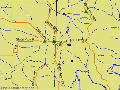
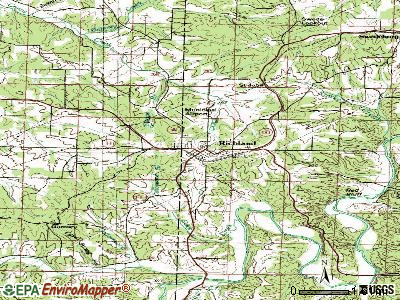
- OSM Map
- General Map
- Google Map
- MSN Map

Population change since 2000: -3.8%
 |
| Males: 911 | |
| Females: 825 |
| Median resident age: | 32.9 years |
| Missouri median age: | 39.1 years |
Zip codes: 65556.
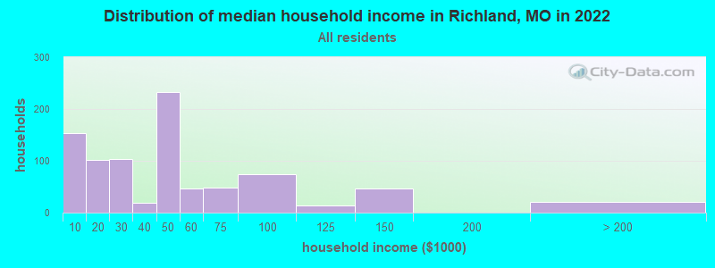
| Richland: | $41,845 |
| MO: | $64,811 |
Estimated per capita income in 2022: $31,725 (it was $14,209 in 2000)
Richland city income, earnings, and wages data
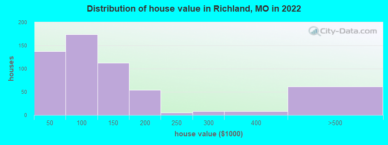
Estimated median house or condo value in 2022: $98,619 (it was $48,100 in 2000)
| Richland: | $98,619 |
| MO: | $221,200 |
Mean prices in 2022: all housing units: $130,815; detached houses: $136,999; mobile homes: $27,423
Median gross rent in 2022: $636.
(21.1% for White Non-Hispanic residents, 17.0% for Hispanic or Latino residents, 15.8% for other race residents, 41.1% for two or more races residents)
Detailed information about poverty and poor residents in Richland, MO
Compare current foreclosures near Richland, MO:
| Photo | Address | Area | Beds / Baths | Price | Details |
|---|---|---|---|---|---|

|
#1
Oaklawn Rd
Richland, MO 65556
|
- sq. feet
|
- baths - beds |
show details | |

|
#2
Kelly Dr
Richland, MO 65556
|
- sq. feet
|
- baths - beds |
show details | |

|
#3
Ranger Rd
Richland, MO 65556
|
- sq. feet
|
- baths - beds |
show details | |

|
#4
Route 66
Richland, MO 65556
|
- sq. feet
|
- baths - beds |
show details | |

|
#5
Village Dr
Richland, MO 65556
|
- sq. feet
|
- baths - beds |
show details | |

|
#6
Sherwood Ln
Laquey, MO 65534
|
1,560 sq. feet
|
2 baths 3 beds |
$189,900
|
show details |

|
#7
N Pine St
Richland, MO 65556
|
- sq. feet
|
- baths - beds |
show details | |

|
#8
Ridgeview Dr
Saint Robert, MO 65584
|
1,877 sq. feet
|
3 baths 5 beds |
show details | |

|
#9
Carat Ln
Dixon, MO 65459
|
1,560 sq. feet
|
2 baths 3 beds |
show details | |

|
#10
Osborn Dr
Lebanon, MO 65536
|
2,283 sq. feet
|
1 baths - beds |
show details |
| Photo | Address | Area | Beds / Baths | Price | Details |
|---|---|---|---|---|---|

|
#11
Lafayette Rd
Waynesville, MO 65583
|
- sq. feet
|
- baths - beds |
show details | |

|
#12
Riley Rd
Montreal, MO 65591
|
- sq. feet
|
- baths - beds |
show details | |

|
#13
A O Kae Ln
Montreal, MO 65591
|
- sq. feet
|
- baths - beds |
show details | |

|
#14
Old Route 66
Saint Robert, MO 65584
|
- sq. feet
|
- baths - beds |
show details | |

|
#15
Pawnee Dr
Lebanon, MO 65536
|
- sq. feet
|
- baths - beds |
show details | |

|
#16
Talon Ln
Saint Robert, MO 65584
|
- sq. feet
|
- baths - beds |
show details | |

|
#17
Talon Ln
Saint Robert, MO 65584
|
- sq. feet
|
- baths - beds |
show details | |

|
#18
Red Bird Ln
Waynesville, MO 65583
|
- sq. feet
|
- baths - beds |
show details | |

|
#19
Osgood Dr
Lebanon, MO 65536
|
- sq. feet
|
- baths - beds |
show details | |

|
#20
Transit Rd
Saint Robert, MO 65584
|
- sq. feet
|
- baths - beds |
show details |
| Photo | Address | Area | Beds / Baths | Price | Details |
|---|---|---|---|---|---|

|
#21
Homer St
Saint Robert, MO 65584
|
- sq. feet
|
- baths - beds |
show details | |

|
#22
Howard Ln
Dixon, MO 65459
|
- sq. feet
|
- baths - beds |
show details | |

|
#23
Highway C
Brumley, MO 65017
|
- sq. feet
|
- baths - beds |
show details | |

|
#24
Green Hills Rd
Lebanon, MO 65536
|
- sq. feet
|
- baths - beds |
show details | |

|
#25
Highway C
Brumley, MO 65017
|
- sq. feet
|
- baths - beds |
show details | |

|
#26
Knight St
Fort Leonard Wood, MO 65473
|
- sq. feet
|
- baths - beds |
show details | |

|
#27
Throttled Dr
Saint Robert, MO 65584
|
- sq. feet
|
- baths - beds |
show details | |

|
#28
Highway 17
Crocker, MO 65452
|
- sq. feet
|
- baths - beds |
show details | |

|
#29
Jefferies Cir
Montreal, MO 65591
|
- sq. feet
|
- baths - beds |
show details | |

|
#30
Carter St Apt 27g
Saint Robert, MO 65584
|
- sq. feet
|
- baths - beds |
show details |
| Photo | Address | Area | Beds / Baths | Price | Details |
|---|---|---|---|---|---|

|
#31
Lilly Ln
Waynesville, MO 65583
|
- sq. feet
|
- baths - beds |
show details | |

|
#32
Lyle Curtis Cir # A
Waynesville, MO 65583
|
- sq. feet
|
- baths - beds |
show details | |

|
#33
Fritts Cir
Waynesville, MO 65583
|
- sq. feet
|
- baths - beds |
show details | |

|
#34
Belle Rd
Crocker, MO 65452
|
- sq. feet
|
- baths - beds |
show details | |

|
#35
Rudolph Rd
Waynesville, MO 65583
|
- sq. feet
|
- baths - beds |
show details | |

|
#36
College St
Crocker, MO 65452
|
- sq. feet
|
- baths - beds |
show details | |

|
#37
Spokane Ln
Laquey, MO 65534
|
- sq. feet
|
- baths - beds |
show details | |

|
#38
Strate Ln
Laquey, MO 65534
|
- sq. feet
|
- baths - beds |
show details | |

|
#39
Southside Rd
Waynesville, MO 65583
|
- sq. feet
|
- baths - beds |
show details | |

|
#40
Dyer St
Waynesville, MO 65583
|
- sq. feet
|
- baths - beds |
show details |
| Photo | Address | Area | Beds / Baths | Price | Details |
|---|---|---|---|---|---|

|
#41
Steer Rd
Waynesville, MO 65583
|
- sq. feet
|
- baths - beds |
show details | |

|
#42
London Ln
Waynesville, MO 65583
|
- sq. feet
|
- baths - beds |
show details | |

|
#43
Ladera Rd
Waynesville, MO 65583
|
- sq. feet
|
- baths - beds |
show details | |

|
#44
Skyview Dr Apt C
Waynesville, MO 65583
|
- sq. feet
|
- baths - beds |
show details | |

|
#45
Smith Ln
Saint Robert, MO 65584
|
- sq. feet
|
- baths - beds |
show details | |

|
#46
Locust Ct
Saint Robert, MO 65584
|
- sq. feet
|
- baths - beds |
show details | |

|
#47
Elm St
Waynesville, MO 65583
|
- sq. feet
|
- baths - beds |
show details | |

|
#48
Eastlawn Ave
Saint Robert, MO 65584
|
- sq. feet
|
- baths - beds |
show details | |

|
#49
Hollyhock Ln
Lebanon, MO 65536
|
- sq. feet
|
- baths - beds |
show details | |

|
Check over 1 million property listings on Foreclosure.com!
|
browse all offers | |||


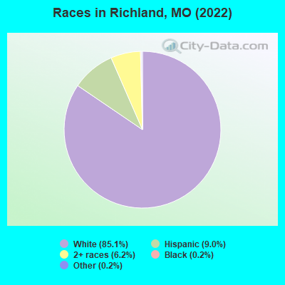
- 1,97085.1%White alone
- 2089.0%Hispanic
- 1436.2%Two or more races
- 40.2%Black alone
- 40.2%Other race alone
Races in Richland detailed stats: ancestries, foreign born residents, place of birth
According to our research of Missouri and other state lists, there were 23 registered sex offenders living in Richland, Missouri as of May 15, 2024.
The ratio of all residents to sex offenders in Richland is 88 to 1.
Type |
2009 |
2010 |
2011 |
2012 |
2013 |
2014 |
2015 |
2016 |
2017 |
2018 |
2019 |
2020 |
2021 |
2022 |
|---|---|---|---|---|---|---|---|---|---|---|---|---|---|---|
| Murders (per 100,000) | 0 (0.0) | 0 (0.0) | 0 (0.0) | 0 (0.0) | 0 (0.0) | 0 (0.0) | 0 (0.0) | 0 (0.0) | 0 (0.0) | 0 (0.0) | 0 (0.0) | 0 (0.0) | 0 (0.0) | 0 (0.0) |
| Rapes (per 100,000) | 0 (0.0) | 0 (0.0) | 1 (53.5) | 1 (52.6) | 2 (105.9) | 2 (106.7) | 1 (54.7) | 1 (55.1) | 0 (0.0) | 3 (170.6) | 0 (0.0) | 2 (112.0) | 0 (0.0) | 0 (0.0) |
| Robberies (per 100,000) | 0 (0.0) | 0 (0.0) | 0 (0.0) | 0 (0.0) | 2 (105.9) | 1 (53.4) | 0 (0.0) | 0 (0.0) | 0 (0.0) | 0 (0.0) | 1 (56.9) | 0 (0.0) | 0 (0.0) | 0 (0.0) |
| Assaults (per 100,000) | 7 (393.7) | 7 (375.7) | 6 (320.9) | 3 (157.9) | 5 (264.8) | 6 (320.2) | 3 (164.1) | 2 (110.2) | 7 (391.5) | 4 (227.4) | 8 (455.3) | 2 (112.0) | 0 (0.0) | 2 (115.9) |
| Burglaries (per 100,000) | 11 (618.7) | 14 (751.5) | 13 (695.2) | 11 (578.9) | 19 (1,006) | 18 (960.5) | 9 (492.3) | 24 (1,322) | 10 (559.3) | 21 (1,194) | 12 (683.0) | 2 (112.0) | 5 (279.2) | 1 (57.9) |
| Thefts (per 100,000) | 59 (3,318) | 42 (2,254) | 74 (3,957) | 36 (1,895) | 40 (2,119) | 38 (2,028) | 24 (1,313) | 39 (2,149) | 19 (1,063) | 26 (1,478) | 39 (2,220) | 28 (1,569) | 21 (1,173) | 17 (984.9) |
| Auto thefts (per 100,000) | 0 (0.0) | 1 (53.7) | 0 (0.0) | 1 (52.6) | 2 (105.9) | 2 (106.7) | 2 (109.4) | 3 (165.3) | 1 (55.9) | 6 (341.1) | 3 (170.7) | 1 (56.0) | 1 (55.8) | 5 (289.7) |
| Arson (per 100,000) | 0 (0.0) | 1 (53.7) | 0 (0.0) | 0 (0.0) | 2 (105.9) | 0 (0.0) | 0 (0.0) | 0 (0.0) | 1 (55.9) | 1 (56.9) | 0 (0.0) | 2 (112.0) | 0 (0.0) | 0 (0.0) |
| City-Data.com crime index | 254.8 | 222.2 | 313.9 | 194.2 | 333.2 | 322.3 | 172.3 | 257.9 | 164.4 | 351.9 | 258.4 | 187.1 | 70.9 | 89.8 |
The City-Data.com crime index weighs serious crimes and violent crimes more heavily. Higher means more crime, U.S. average is 246.1. It adjusts for the number of visitors and daily workers commuting into cities.
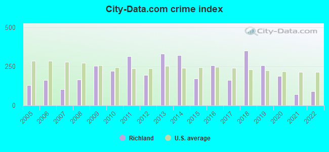
Crime rate in Richland detailed stats: murders, rapes, robberies, assaults, burglaries, thefts, arson
Full-time law enforcement employees in 2021, including police officers: 5 (5 officers - 4 male; 1 female).
| Officers per 1,000 residents here: | 2.79 |
| Missouri average: | 2.54 |
 Recent articles from our blog. Our writers, many of them Ph.D. graduates or candidates, create easy-to-read articles on a wide variety of topics.

 | Missouri Outlaw History (3407 replies) |
| Anyone move from Texas to Missouri? (0 replies) |
| Visiting Southern Missouri as a "Brown guy" (18 replies) |
| Nursing School's Around Springfield (1 reply) |
| KC ranked #2 on "redneck city" list (243 replies) |
| Tell me about Dixon, Crocker, and Richland (2 replies) |
Latest news from Richland, MO collected exclusively by city-data.com from local newspapers, TV, and radio stations
Ancestries: English (24.9%), German (11.9%), American (10.9%), Irish (8.7%), Norwegian (6.5%), Scottish (4.9%).
Current Local Time: CST time zone
Incorporated in 1884
Elevation: 1135 feet
Land area: 2.27 square miles.
Population density: 765 people per square mile (low).
15 residents are foreign born
| This city: | 0.6% |
| Missouri: | 4.2% |
Median real estate property taxes paid for housing units with mortgages in 2022: $496 (0.4%)
Median real estate property taxes paid for housing units with no mortgage in 2022: $359 (0.4%)
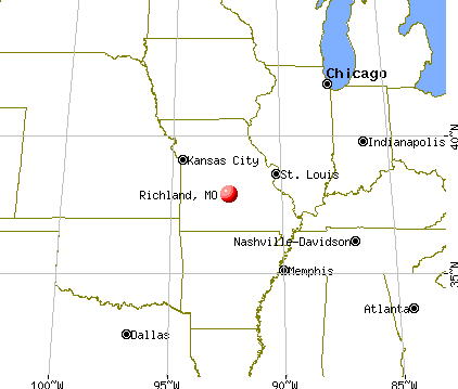
Nearest city with pop. 50,000+: Springfield, MO  (66.8 miles , pop. 151,580).
Nearest city with pop. 200,000+: St. Louis, MO (128.8 miles , pop. 348,189).
Nearest city with pop. 1,000,000+: Chicago, IL (372.4 miles , pop. 2,896,016).
Nearest cities:
), ), Latitude: 37.86 N, Longitude: 92.40 W
Area code: 573
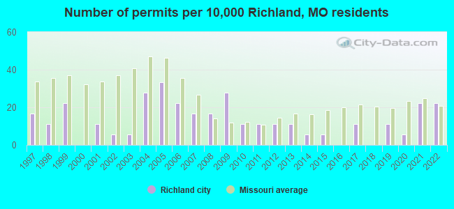
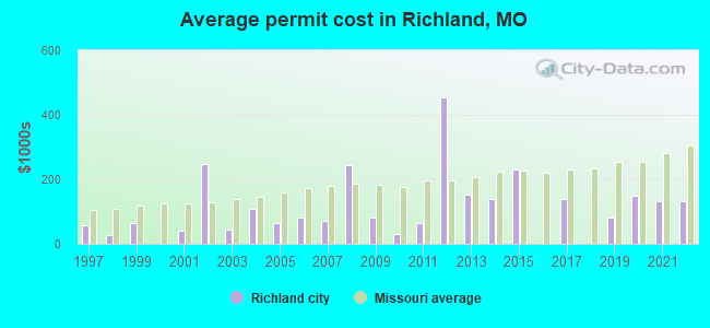
Single-family new house construction building permits:
- 2022: 4 buildings, average cost: $132,400
- 2021: 4 buildings, average cost: $132,400
- 2020: 1 building, cost: $149,000
- 2019: 2 buildings, average cost: $80,000
- 2017: 2 buildings, average cost: $140,000
- 2015: 1 building, cost: $230,000
- 2014: 1 building, cost: $140,000
- 2013: 2 buildings, average cost: $153,500
- 2012: 2 buildings, average cost: $453,600
- 2011: 2 buildings, average cost: $65,000
- 2010: 2 buildings, average cost: $30,000
- 2009: 5 buildings, average cost: $81,200
- 2008: 3 buildings, average cost: $243,300
- 2007: 3 buildings, average cost: $71,300
- 2006: 4 buildings, average cost: $82,300
- 2005: 6 buildings, average cost: $63,300
- 2004: 5 buildings, average cost: $109,000
- 2003: 1 building, cost: $45,000
- 2002: 1 building, cost: $247,000
- 2001: 2 buildings, average cost: $40,000
- 1999: 4 buildings, average cost: $65,000
- 1998: 2 buildings, average cost: $27,300
- 1997: 3 buildings, average cost: $58,300
| Here: | 3.3% |
| Missouri: | 2.8% |
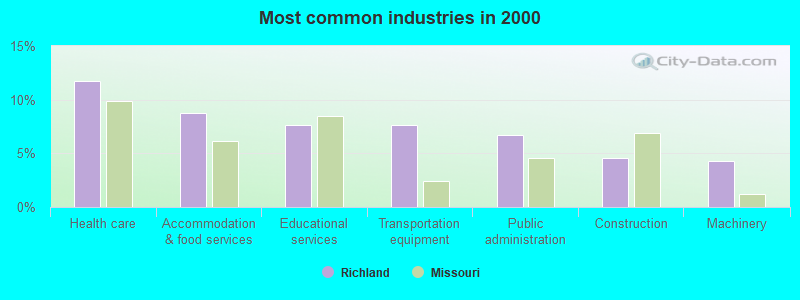
- Health care (11.8%)
- Accommodation & food services (8.8%)
- Educational services (7.6%)
- Transportation equipment (7.6%)
- Public administration (6.7%)
- Construction (4.6%)
- Machinery (4.3%)
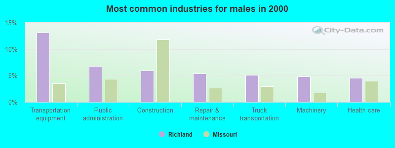
- Transportation equipment (13.1%)
- Public administration (6.8%)
- Construction (6.0%)
- Repair & maintenance (5.4%)
- Truck transportation (5.1%)
- Machinery (4.8%)
- Health care (4.6%)

- Health care (19.1%)
- Accommodation & food services (13.9%)
- Educational services (11.0%)
- Public administration (6.6%)
- Social assistance (5.2%)
- Food & beverage stores (4.6%)
- Finance & insurance (4.0%)
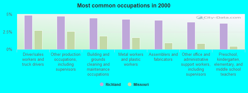
- Driver/sales workers and truck drivers (4.9%)
- Other production occupations, including supervisors (4.7%)
- Building and grounds cleaning and maintenance occupations (4.4%)
- Metal workers and plastic workers (4.3%)
- Assemblers and fabricators (4.2%)
- Other office and administrative support workers, including supervisors (3.9%)
- Preschool, kindergarten, elementary, and middle school teachers (3.7%)
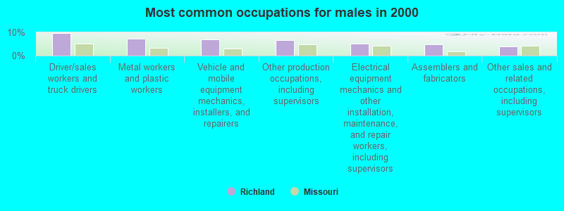
- Driver/sales workers and truck drivers (9.7%)
- Metal workers and plastic workers (7.1%)
- Vehicle and mobile equipment mechanics, installers, and repairers (6.8%)
- Other production occupations, including supervisors (6.6%)
- Electrical equipment mechanics and other installation, maintenance, and repair workers, including supervisors (5.1%)
- Assemblers and fabricators (4.8%)
- Other sales and related occupations, including supervisors (4.0%)
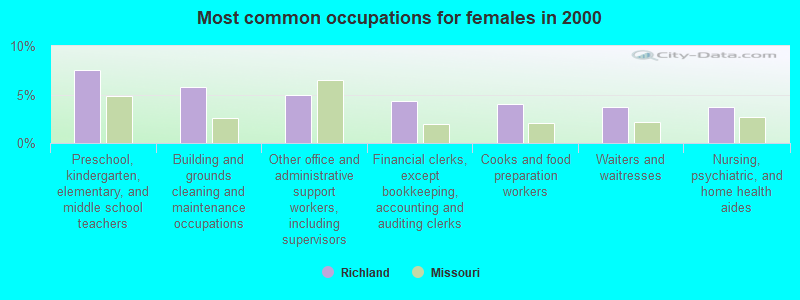
- Preschool, kindergarten, elementary, and middle school teachers (7.5%)
- Building and grounds cleaning and maintenance occupations (5.8%)
- Other office and administrative support workers, including supervisors (4.9%)
- Financial clerks, except bookkeeping, accounting and auditing clerks (4.3%)
- Cooks and food preparation workers (4.0%)
- Waiters and waitresses (3.8%)
- Nursing, psychiatric, and home health aides (3.8%)
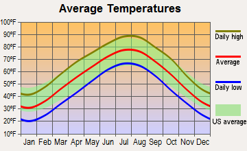
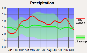
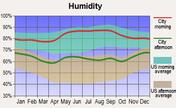
Average climate in Richland, Missouri
Based on data reported by over 4,000 weather stations
|
|

Tornado activity:
Richland-area historical tornado activity is slightly below Missouri state average. It is 18% greater than the overall U.S. average.
On 9/26/1959, a category F4 (max. wind speeds 207-260 mph) tornado 31.0 miles away from the Richland city center caused between $50,000 and $500,000 in damages.
On 3/25/1954, a category F4 tornado 33.4 miles away from the city center killed 2 people and caused between $5000 and $50,000 in damages.
Earthquake activity:
Richland-area historical earthquake activity is significantly above Missouri state average. It is 469% greater than the overall U.S. average.On 9/3/2016 at 12:02:44, a magnitude 5.8 (5.8 MW, Depth: 3.5 mi, Class: Moderate, Intensity: VI - VII) earthquake occurred 268.5 miles away from Richland center
On 11/6/2011 at 03:53:10, a magnitude 5.7 (5.7 MW, Depth: 3.2 mi) earthquake occurred 290.5 miles away from Richland center
On 9/26/1990 at 13:18:51, a magnitude 5.0 (4.7 MB, 4.8 LG, 5.0 LG, Depth: 7.7 mi) earthquake occurred 164.4 miles away from Richland center
On 5/4/1991 at 01:18:54, a magnitude 5.0 (4.4 MB, 4.6 LG, 5.0 LG, Depth: 3.1 mi) earthquake occurred 168.0 miles away from Richland center
On 4/18/2008 at 09:36:59, a magnitude 5.4 (5.1 MB, 4.8 MS, 5.4 MW, 5.2 MW) earthquake occurred 249.0 miles away from the city center
On 3/25/1976 at 00:41:20, a magnitude 5.0 (4.9 MB, 5.0 LG) earthquake occurred 192.0 miles away from the city center
Magnitude types: regional Lg-wave magnitude (LG), body-wave magnitude (MB), surface-wave magnitude (MS), moment magnitude (MW)
Natural disasters:
The number of natural disasters in Pulaski County (23) is greater than the US average (15).Major Disasters (Presidential) Declared: 14
Emergencies Declared: 6
Causes of natural disasters: Floods: 15, Storms: 13, Tornadoes: 12, Winter Storms: 5, Winds: 4, Drought: 1, Heavy Rain: 1, Hurricane: 1, Snowstorm: 1, Other: 1 (Note: some incidents may be assigned to more than one category).
Hospitals and medical centers in Richland:
Airports located in Richland:
- Richland Municipal Airport (MO1) (Runways: 1, Itinerant Ops: 250, Local Ops: 200, Military Ops: 40)
Colleges/universities with over 2000 students nearest to Richland:
- Missouri University of Science and Technology (about 35 miles; Rolla, MO; Full-time enrollment: 6,486)
- Lincoln University (about 51 miles; Jefferson City, MO; FT enrollment: 2,348)
- Southwest Baptist University (about 58 miles; Bolivar, MO; FT enrollment: 2,783)
- Evangel University (about 65 miles; Springfield, MO; FT enrollment: 2,036)
- Ozarks Technical Community College (about 66 miles; Springfield, MO; FT enrollment: 10,356)
- Drury University (about 66 miles; Springfield, MO; FT enrollment: 3,902)
- Missouri State University-Springfield (about 67 miles; Springfield, MO; FT enrollment: 16,660)
Public high school in Richland:
- RICHLAND HIGH (Students: 91, Location: 714 E JEFFERSON, Grades: 9-12)
Public elementary/middle schools in Richland:
- RICHLAND ELEM. (Students: 211, Location: 714 E JEFFERSON, Grades: PK-6)
- SWEDEBORG ELEM. (Students: 47, Location: 17507 HWY T, Grades: PK-8)
- RICHLAND JR. HIGH (Location: 714 E JEFFERSON, Grades: 7-8)
Points of interest:
Notable locations in Richland: Tri - County Fire and Rescue Association Station 1 (A), Tri - County Fire and Rescue Association Station 3 (B). Display/hide their locations on the map
Cemetery: Oaklawn Cemetery (1). Display/hide its location on the map
Drinking water stations with addresses in Richland and their reported violations in the past:
THE CAVE RESTAURANT & RESORT (Population served: 65, Groundwater):Past health violations:Past monitoring violations:
- MCL, Monthly (TCR) - In JUL-2013, Contaminant: Coliform. Follow-up actions: St Public Notif requested (JUL-25-2013), St Formal NOV issued (JUL-25-2013), St Violation/Reminder Notice (AUG-06-2013), St Public Notif received (AUG-29-2013), St Compliance achieved (NOV-18-2013)
- MCL, Monthly (TCR) - In MAR-2013, Contaminant: Coliform. Follow-up actions: St Public Notif requested (MAR-22-2013), St Formal NOV issued (MAR-22-2013), St Violation/Reminder Notice (AUG-06-2013), St Public Notif received (OCT-01-2013), St Compliance achieved (JAN-22-2014)
- MCL, Monthly (TCR) - In FEB-2013, Contaminant: Coliform. Follow-up actions: St Public Notif requested (MAR-01-2013), St Formal NOV issued (MAR-01-2013), St Violation/Reminder Notice (AUG-06-2013), St Public Notif received (OCT-01-2013), St Compliance achieved (JAN-22-2014)
- MCL, Monthly (TCR) - In FEB-2012, Contaminant: Coliform. Follow-up actions: St Public Notif requested (FEB-21-2012), St Violation/Reminder Notice (FEB-21-2012), St Public Notif received (APR-10-2012), St Violation/Reminder Notice (JUL-27-2012), St Public Notif issued (AUG-21-2012), St Compliance achieved (SEP-30-2012)
- Monitoring, Source Water (GWR) - In JUN-01-2014, Contaminant: E. COLI
- Monitoring, Repeat Major (TCR) - In MAY-2014, Contaminant: Coliform (TCR)
- Monitoring, Source Water (GWR) - In APR-01-2013, Contaminant: E. COLI. Follow-up actions: St Public Notif requested (APR-24-2013), St Violation/Reminder Notice (APR-24-2013), St Public Notif received (OCT-01-2013), St Compliance achieved (NOV-18-2013)
- Monitoring, Source Water (GWR) - In JAN-01-2013, Contaminant: E. COLI. Follow-up actions: St Public Notif requested (FEB-01-2013), St Violation/Reminder Notice (FEB-01-2013), St Public Notif received (FEB-15-2013), St Compliance achieved (NOV-18-2013)
- 5 routine major monitoring violations
- One minor monitoring violation
- One regular monitoring violation
| This city: | 2.3 people |
| Missouri: | 2.5 people |
| This city: | 60.0% |
| Whole state: | 65.3% |
| This city: | 7.7% |
| Whole state: | 6.7% |
Likely homosexual households (counted as self-reported same-sex unmarried-partner households)
- Lesbian couples: 0.4% of all households
- Gay men: 0.0% of all households
45 people in nursing homes in 2000
Banks with branches in Richland (2011 data):
- Bank of America, National Association: Richland Motor Bank Branch at 107 W Camden Ave, branch established on 2011/05/31; Richland Branch at 112 Mcclurg Avenue, branch established on 1889/06/05. Info updated 2009/11/18: Bank assets: $1,451,969.3 mil, Deposits: $1,077,176.8 mil, headquarters in Charlotte, NC, positive income, 5782 total offices, Holding Company: Bank Of America Corporation
- Bank of Crocker: Richland Branch at 502 Washington, branch established on 1998/01/13. Info updated 2009/04/08: Bank assets: $144.6 mil, Deposits: $119.5 mil, headquarters in Waynesville, MO, positive income, Commercial Lending Specialization, 4 total offices
- First State Bank of St. Robert: Richland Branch at 102 North Pine, branch established on 1997/04/21. Info updated 2006/11/03: Bank assets: $94.0 mil, Deposits: $83.4 mil, headquarters in Saint Robert, MO, positive income, 2 total offices, Holding Company: Maries County Bancorp., Inc.
For population 15 years and over in Richland:
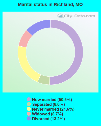
- Never married: 21.6%
- Now married: 50.5%
- Separated: 6.0%
- Widowed: 8.7%
- Divorced: 13.2%
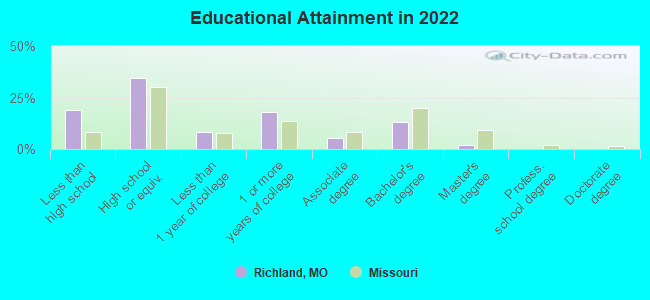
For population 25 years and over in Richland:
- High school or higher: 80.1%
- Bachelor's degree or higher: 14.5%
- Graduate or professional degree: 2.0%
- Unemployed: 8.0%
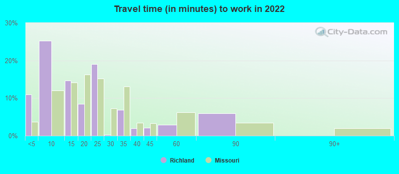
- Mean travel time to work (commute): 23.6 minutes
| Here: | 10.6 |
| Missouri average: | 11.1 |
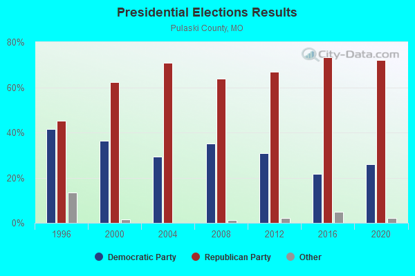
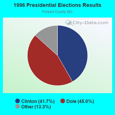
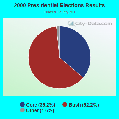
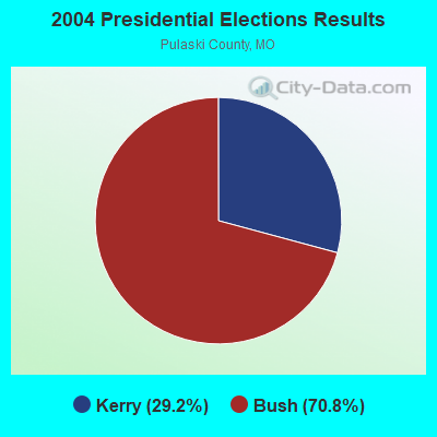
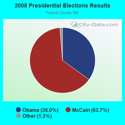
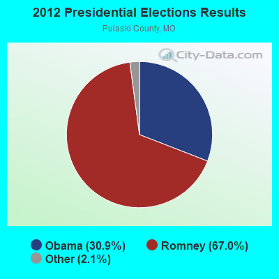
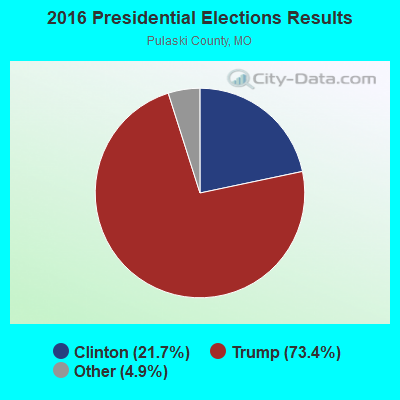
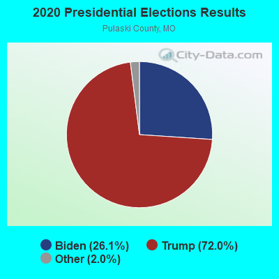
Graphs represent county-level data. Detailed 2008 Election Results
Religion statistics for Richland, MO (based on Pulaski County data)
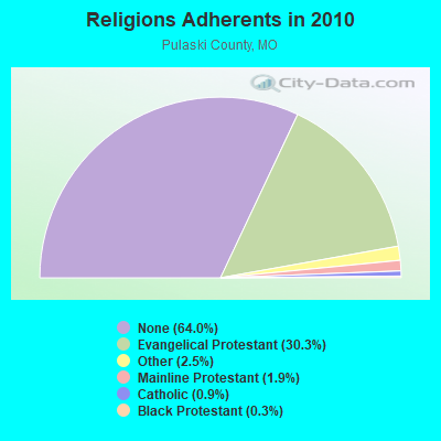
| Religion | Adherents | Congregations |
|---|---|---|
| Evangelical Protestant | 15,862 | 75 |
| Other | 1,327 | 3 |
| Mainline Protestant | 979 | 5 |
| Catholic | 452 | 4 |
| Black Protestant | 180 | 1 |
| None | 33,474 | - |
Food Environment Statistics:
| Here: | 1.13 / 10,000 pop. |
| Missouri: | 1.88 / 10,000 pop. |
| This county: | 0.23 / 10,000 pop. |
| State: | 0.18 / 10,000 pop. |
| This county: | 0.23 / 10,000 pop. |
| Missouri: | 0.60 / 10,000 pop. |
| This county: | 5.19 / 10,000 pop. |
| State: | 4.34 / 10,000 pop. |
| Pulaski County: | 6.77 / 10,000 pop. |
| Missouri: | 7.37 / 10,000 pop. |
| Pulaski County: | 8.0% |
| Missouri: | 8.8% |
| Pulaski County: | 31.9% |
| State: | 29.6% |
| Pulaski County: | 10.7% |
| State: | 13.5% |
Health and Nutrition:
| Here: | 55.5% |
| State: | 50.9% |
| Here: | 54.5% |
| State: | 48.6% |
| Richland: | 28.1 |
| Missouri: | 28.7 |
| This city: | 20.1% |
| Missouri: | 20.6% |
| Richland: | 7.9% |
| Missouri: | 10.1% |
| Richland: | 7.0 |
| State: | 6.8 |
| Richland: | 35.4% |
| Missouri: | 34.3% |
| This city: | 61.3% |
| Missouri: | 57.5% |
| Richland: | 78.9% |
| State: | 79.3% |
More about Health and Nutrition of Richland, MO Residents
| Local government employment and payroll (March 2022) | |||||
| Function | Full-time employees | Monthly full-time payroll | Average yearly full-time wage | Part-time employees | Monthly part-time payroll |
|---|---|---|---|---|---|
| Police Protection - Officers | 4 | $11,443 | $34,329 | 0 | $0 |
| Financial Administration | 3 | $16,235 | $64,940 | 1 | $100 |
| Sewerage | 2 | $8,839 | $53,034 | 0 | $0 |
| Gas Supply | 2 | $4,659 | $27,954 | 0 | $0 |
| Other Government Administration | 1 | $3,264 | $39,168 | 0 | $0 |
| Electric Power | 1 | $4,429 | $53,148 | 0 | $0 |
| Water Supply | 1 | $2,686 | $32,232 | 0 | $0 |
| Streets and Highways | 1 | $2,445 | $29,340 | 0 | $0 |
| Police - Other | 0 | $0 | 1 | $1,185 | |
| Totals for Government | 15 | $54,000 | $43,200 | 2 | $1,284 |
Richland government finances - Expenditure in 2017 (per resident):
- Current Operations - Electric Utilities: $2,249,000 ($1295.51)
Police Protection: $405,000 ($233.29)
Sewerage: $217,000 ($125.00)
Gas Utilities: $214,000 ($123.27)
Water Utilities: $205,000 ($118.09)
General - Other: $201,000 ($115.78)
Solid Waste Management: $74,000 ($42.63)
Judicial and Legal Services: $39,000 ($22.47)
Miscellaneous Commercial Activities - Other: $10,000 ($5.76)
Air Transportation: $6,000 ($3.46)
- Total Salaries and Wages: $775,000 ($446.43)
- Water Utilities - Interest on Debt: $44,000 ($25.35)
Richland government finances - Revenue in 2017 (per resident):
- Charges - Sewerage: $217,000 ($125.00)
Solid Waste Management: $78,000 ($44.93)
Parks and Recreation: $42,000 ($24.19)
Miscellaneous Commercial Activities: $10,000 ($5.76)
- Miscellaneous - General Revenue - Other: $17,000 ($9.79)
Fines and Forfeits: $9,000 ($5.18)
Rents: $7,000 ($4.03)
- Revenue - Electric Utilities: $1,998,000 ($1150.92)
Gas Utilities: $236,000 ($135.94)
Water Utilities: $205,000 ($118.09)
- State Intergovernmental - Highways: $50,000 ($28.80)
- Tax - Property: $93,000 ($53.57)
Public Utilities Sales: $57,000 ($32.83)
Occupation and Business License - Other: $4,000 ($2.30)
Alcoholic Beverage License: $1,000 ($0.58)
Other License: $1,000 ($0.58)
Richland government finances - Debt in 2017 (per resident):
- Long Term Debt - Beginning Outstanding - Unspecified Public Purpose: $1,085,000 ($625.00)
Outstanding Unspecified Public Purpose: $955,000 ($550.12)
Retired Unspecified Public Purpose: $130,000 ($74.88)
Richland government finances - Cash and Securities in 2017 (per resident):
- Other Funds - Cash and Securities: $1,623,000 ($934.91)
16.51% of this county's 2021 resident taxpayers lived in other counties in 2020 ($50,102 average adjusted gross income)
| Here: | 16.51% |
| Missouri average: | 7.67% |
0.88% of residents moved from foreign countries ($2,950 average AGI)
Pulaski County: 0.88% Missouri average: 0.02%
Top counties from which taxpayers relocated into this county between 2020 and 2021:
| from Phelps County, MO | |
| from Laclede County, MO | |
| from El Paso County, CO |
16.82% of this county's 2020 resident taxpayers moved to other counties in 2021 ($53,046 average adjusted gross income)
| Here: | 16.82% |
| Missouri average: | 7.51% |
0.67% of residents moved to foreign countries ($2,293 average AGI)
Pulaski County: 0.67% Missouri average: 0.01%
Top counties to which taxpayers relocated from this county between 2020 and 2021:
| to Phelps County, MO | |
| to Bell County, TX | |
| to El Paso County, CO |
Businesses in Richland, MO
- FedEx: 1
- H&R Block: 1
Strongest AM radio stations in Richland:
- KJPW (1390 AM; 5 kW; WAYNESVILLE, MO; Owner: PULASKI COUNTY BROADCASTERS, INC.)
- KBNN (750 AM; daytime; 5 kW; LEBANON, MO; Owner: OZARK BROADCASTING, INC.)
- KRMS (1150 AM; 10 kW; OSAGE BEACH, MO; Owner: VIPER COMMUNICATIONS, INC)
- WHB (810 AM; 50 kW; KANSAS CITY, MO; Owner: UNION BROADCASTING, INC.)
- KOZQ (1270 AM; 0 kW; WAYNESVILLE, MO; Owner: FIDELITY BROADCASTING, INC.)
- KXEN (1010 AM; 50 kW; FESTUS-ST. LOUIS, MO; Owner: BDJ RADIO ENTERPRISES, LLC)
- KWOS (950 AM; 5 kW; JEFFERSON CITY, MO; Owner: ZIMMER RADIO OF MID-MISSOURI, INC.)
- KMOX (1120 AM; 50 kW; ST. LOUIS, MO; Owner: INFINITY BROADCASTING OPERATIONS, INC.)
- KLWT (1230 AM; 1 kW; LEBANON, MO; Owner: PEARSON BROADCASTING OF LEBANON, INC.)
- KLIK (1240 AM; 5 kW; JEFFERSON CITY, MO; Owner: PREMIER RADIO GROUP)
- KMRF (1510 AM; daytime; 5 kW; MARSHFIELD, MO; Owner: NEW LIFE EVANGELISTIC CENTER, INC.)
- KWTO (560 AM; 5 kW; SPRINGFIELD, MO; Owner: KWTO, INC.)
- WCRV (640 AM; 50 kW; COLLIERVILLE, TN; Owner: BOTT BROADCASTING COMPANY/TENNESSEE)
Strongest FM radio stations in Richland:
- KFBD-FM (97.9 FM; WAYNESVILLE, MO; Owner: FIDELITY BROADCASTING, INC.)
- KCLQ (107.9 FM; LEBANON, MO; Owner: PEARSON BROADCASTING OF LEBANON, INC.)
- KJEL (103.7 FM; LEBANON, MO; Owner: OZARK BROADCASTING, INC.)
- KJPW-FM (102.3 FM; WAYNESVILLE, MO; Owner: PULASKI COUNTY BROADCASTERS, INC.)
- KTTK (90.7 FM; LEBANON, MO; Owner: LEBANON EDUCATIONAL BROADCASTING FOUNDATION)
- KQUL (102.7 FM; LAKE OZARK, MO; Owner: BENNE B/CO CO. OF LAKE OZARK,INC)
- KRMS-FM (93.5 FM; OSAGE BEACH, MO; Owner: VIPER COMMUNICATIONS, INC.)
- K285ER (104.9 FM; OSAGE BEACH, MO; Owner: BD OF GOVERNORS, CENTRAL MO ST. U.)
- KTXR (101.3 FM; SPRINGFIELD, MO; Owner: STEREO BROADCASTING, INC.)
- KCVO-FM (91.7 FM; CAMDENTON, MO; Owner: LAKE AREA EDUCATIONAL BROADCASTING FOUNDATION)
- KFLW (98.9 FM; ST. ROBERT, MO; Owner: OZARK MEDIA)
- KLOZ (92.7 FM; ELDON, MO; Owner: BENNE BROADCASTING COMPANY, LLC)
- K201AA (88.1 FM; BOLIVAR, MO; Owner: LAKE AREA EDUCATIONAL BROADCASTING FOUNDATION)
- K242AN (96.3 FM; LEBANON, MO; Owner: CURATORS OF THE UNIV. OF MISSOURI)
TV broadcast stations around Richland:
- KYTV (Channel 3; SPRINGFIELD, MO; Owner: KY3, INC.)
- K64FQ (Channel 64; LEBANON, MO; Owner: NEW LIFE EVANGELISTIC CENTER, INC.)
- KSPR (Channel 33; SPRINGFIELD, MO; Owner: PIEDMONT TELEVISION OF SPRINGFIELD LICENSE LLC)
- KOZK (Channel 21; SPRINGFIELD, MO; Owner: BD. OF GOVERNORS OF SW MISSOURI STATE UNIVERSITY)
- KOLR (Channel 10; SPRINGFIELD, MO; Owner: VHR SPRINGFIELD LICENSE, INC.)
- KMOS-TV (Channel 6; SEDALIA, MO; Owner: BOARD OF GOVERNORS OF CENTRAL MISSOURI STATE UNIVERSITY)
- KDEB-TV (Channel 27; SPRINGFIELD, MO; Owner: QUORUM OF MISSOURI LICENSE, LLC)
Richland fatal accident list:
Aug 28, 1995 00:25 AM, 7, Vehicles: 1, Persons: 6, Fatalities: 3
Jun 21, 1990 09:45 PM, 7, Vehicles: 2, Persons: 2, Fatalities: 1
Jan 6, 1984 03:50 PM, Walnut, Vehicles: 1, Persons: 2, Fatalities: 2
Jun 29, 1984 00:45 AM, Mildred St, Vehicles: 1, Persons: 1, Fatalities: 1
- National Bridge Inventory (NBI) Statistics
- 14Number of bridges
- 197ft / 59.9mTotal length
- $820,000Total costs
- 13,045Total average daily traffic
- 1,473Total average daily truck traffic
- 20,540Total future (year 2040) average daily traffic
- New bridges - historical statistics
- 11930-1939
- 21940-1949
- 11950-1959
- 51960-1969
- 11970-1979
- 41990-1999
FCC Registered Cell Phone Towers:
1 (See the full list of FCC Registered Cell Phone Towers in Richland)FCC Registered Antenna Towers:
45 (See the full list of FCC Registered Antenna Towers)FCC Registered Broadcast Land Mobile Towers:
4- 201 S Chestnut St (Lat: 37.857972 Lon: -92.405083), Type: Tank, Structure height: 39.6 m, Overall height: 45.1 m, Call Sign: KSJ235,
Assigned Frequencies: 155.865 MHz, 155.137 MHz, Grant Date: 08/30/2023, Expiration Date: 08/24/2033, Registrant: Wireless Usa, 2519 Mccarty St, Jefferson City, MO 65101, Phone: (573) 659-8228, Email:
- 1/4 Mi E Of Hwy 133 1 Mi S Of City Limits (Lat: 37.846694 Lon: -92.407389), Call Sign: KNFH758, Licensee ID: L00043275,
Assigned Frequencies: 155.370 MHz, 155.730 MHz, Grant Date: 02/12/1997, Expiration Date: 04/28/2002, Cancellation Date: 09/01/2002, Registrant: City Of Richland, Richland, MO 65556, Phone: (314) 765-5187
- Lat: 37.857833 Lon: -92.400583, Call Sign: WQYI350,
Assigned Frequencies: 151.730 MHz, Grant Date: 10/06/2016, Expiration Date: 10/06/2026, Certifier: Steve Alexander, Registrant: Atlas License Company & Data Services, 176 West Logan Street, Ste. 227, Noblesville, IN 46060, Phone: (317) 813-4865, Fax: (317) 813-4870, Email:
- Lat: 37.858333 Lon: -92.403639, Call Sign: WSAL263,
Assigned Frequencies: 851.237 MHz, 851.237 MHz, 806.237 MHz, Grant Date: 01/25/2024, Expiration Date: 01/25/2034, Certifier: Russell L Hobbs, Registrant: Wireless Usa, 2519 E Mccarty St, Jefferson City, MO 65101, Phone: (573) 659-8228, Email:
FCC Registered Microwave Towers:
6- RICHLAND, 213 Washington Street (Lat: 37.856444 Lon: -92.401194), Type: Tower, Structure height: 36.6 m, Call Sign: WMN846, Licensee ID: L00121084,
Assigned Frequencies: 6034.15 MHz, 5974.85 MHz, Grant Date: 03/15/2011, Expiration Date: 02/01/2021, Cancellation Date: 05/02/2012, Registrant: Embarq Missouri, Inc., 805 Broadway Suite 800, Vancouver, WA 98660, Phone: (360) 905-6839, Fax: (360) 905-5953, Email:
- N2T1, 18160 Mo-7 (Lat: 37.877611 Lon: -92.452083), Type: Gtower, Structure height: 56 m, Overall height: 57 m, Call Sign: WRFQ370,
Assigned Frequencies: 11245.0 MHz, 11245.0 MHz, 11245.0 MHz, 11245.0 MHz, 11245.0 MHz, 11245.0 MHz, 11245.0 MHz, 11245.0 MHz, 11325.0 MHz, 11325.0 MHz... (+22 more), Grant Date: 04/10/2020, Expiration Date: 04/10/2030, Certifier: Brian Matthews, Registrant: Intelpath, Hinsdale, IL 60522, Phone: (312) 841-9188, Email:
- Tower 21, W Main St (Lat: 37.859222 Lon: -92.411028), Type: Tank, Structure height: 50 m, Overall height: 51 m, Call Sign: WRFQ371,
Assigned Frequencies: 10995.0 MHz, 10995.0 MHz, 10995.0 MHz, 10995.0 MHz, 10995.0 MHz, 10995.0 MHz, 10995.0 MHz, 10995.0 MHz, 10835.0 MHz, 10835.0 MHz... (+40 more), Grant Date: 04/10/2020, Expiration Date: 04/10/2030, Certifier: Brian Matthews, Registrant: Intelpath, Hinsdale, IL 60522, Phone: (312) 841-9188, Email:
- Site 40, Rural Site (Lat: 37.827778 Lon: -92.340556), Type: Ltower, Structure height: 59 m, Overall height: 60 m, Call Sign: WRJD999,
Assigned Frequencies: 10755.0 MHz, 10755.0 MHz, 10755.0 MHz, 10755.0 MHz, 10755.0 MHz, 10755.0 MHz, 10755.0 MHz, 10755.0 MHz, Grant Date: 08/14/2020, Expiration Date: 08/14/2030, Certifier: Brian Matthews, Registrant: Intelpath, Hinsdale, IL 60522, Phone: (312) 841-9188, Email:
- McMahon, No Exact Address (Lat: 37.947083 Lon: -92.458944), Type: Tank, Structure height: 39.6 m, Call Sign: WRXH620,
Assigned Frequencies: 11325.0 MHz, 11325.0 MHz, 11325.0 MHz, 11325.0 MHz, 11325.0 MHz, 11325.0 MHz, 11325.0 MHz, 11325.0 MHz, Grant Date: 05/12/2023, Expiration Date: 05/12/2033, Certifier: Brian Matthews, Registrant: Intelpath, 145, Hinsdale, IL 60522, Phone: (312) 841-9188, Email:
- STATION, 3 Mi Nw Of (Lat: 37.877806 Lon: -92.451000), Overall height: 59.1 m, Call Sign: WEF385,
Assigned Frequencies: 953.500 MHz, 953.000 MHz, Grant Date: 09/24/1998, Expiration Date: 12/16/2008, Cancellation Date: 07/02/2007, Phone: (417) 468-2615
FCC Registered Amateur Radio Licenses:
23 (See the full list of FCC Registered Amateur Radio Licenses in Richland)FAA Registered Aircraft:
2- Aircraft: BALLOON WORKS FIREFLY 5 (Category: Land, Weight: Up to 12,499 Pounds, Speed: 60 mph), Engine: None
N-Number: 4054U, N4054U, N-4054U, Serial Number: 10101, Year manufactured: 1981, Airworthiness Date: 06/30/1981, Certificate Issue Date: 11/24/2014
Registrant (Individual): Todd J Bailey, Po Box 1084, Richland, MO 65556 - Aircraft: ROBERTS JAMES E RIDGE RUNNER MOD III (Category: Land, Weight: Up to 12,499 Pounds), Engine: ROTAX SEE BOMBADIER (Reciprocating)
N-Number: 670JR, N670JR, N-670JR, Serial Number: 050502076, Year manufactured: 2003, Airworthiness Date: 01/24/2003, Certificate Issue Date: 01/09/2003
Registrant (Individual): James E Roberts, 53 Glover Dr, Richland, MO 65556
Deregistered: Cancel Date: 01/26/2018
2002 - 2018 National Fire Incident Reporting System (NFIRS) incidents
- Fire incident types reported to NFIRS in Richland, MO
- 49750.4%Outside Fires
- 35536.0%Structure Fires
- 12012.2%Mobile Property/Vehicle Fires
- 141.4%Other
 According to the data from the years 2002 - 2018 the average number of fire incidents per year is 58. The highest number of reported fires - 94 took place in 2006, and the least - 31 in 2008. The data has a dropping trend.
 When looking into fire subcategories, the most reports belonged to: Outside Fires (50.4%), and Structure Fires (36.0%).
| Most common first names in Richland, MO among deceased individuals | ||
| Name | Count | Lived (average) |
|---|---|---|
| James | 47 | 72.4 years |
| William | 45 | 75.1 years |
| John | 40 | 77.5 years |
| Mary | 30 | 83.4 years |
| Robert | 29 | 68.0 years |
| Charles | 26 | 80.1 years |
| Clarence | 17 | 78.0 years |
| George | 17 | 82.1 years |
| Helen | 15 | 77.0 years |
| Frank | 13 | 75.8 years |
| Most common last names in Richland, MO among deceased individuals | ||
| Last name | Count | Lived (average) |
|---|---|---|
| Miller | 27 | 74.0 years |
| Smith | 24 | 73.9 years |
| York | 20 | 76.4 years |
| Wilson | 20 | 75.2 years |
| Brown | 18 | 76.2 years |
| Henson | 17 | 75.4 years |
| Davis | 15 | 82.9 years |
| Anderson | 15 | 77.0 years |
| Johnson | 15 | 82.5 years |
| Roam | 15 | 77.9 years |
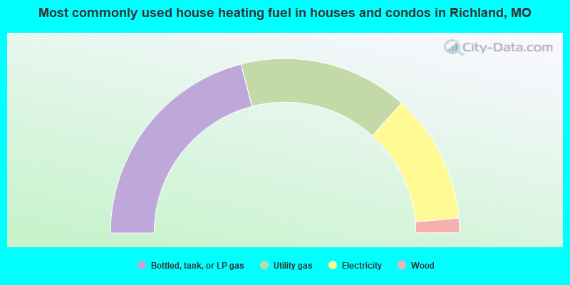
- 41.9%Bottled, tank, or LP gas
- 31.4%Utility gas
- 24.0%Electricity
- 2.7%Wood
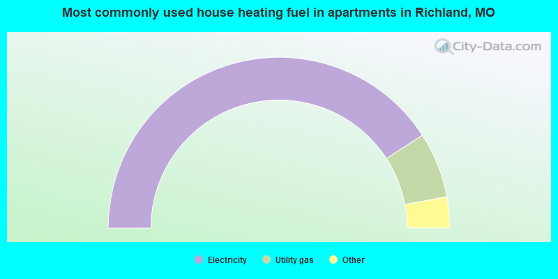
- 82.3%Electricity
- 12.5%Utility gas
- 3.4%Bottled, tank, or LP gas
- 1.7%No fuel used
Richland compared to Missouri state average:
- Median household income below state average.
- Median house value below state average.
- Unemployed percentage below state average.
- Black race population percentage significantly below state average.
- Hispanic race population percentage above state average.
- Median age above state average.
- Foreign-born population percentage significantly below state average.
- Length of stay since moving in significantly below state average.
- Percentage of population with a bachelor's degree or higher below state average.

|
Total of 2 patent applications in 2008-2024.