Rutland, Georgia
Submit your own pictures of this place and show them to the world
- OSM Map
- General Map
- Google Map
- MSN Map

| Males: 5,065 | |
| Females: 5,244 |
| Median resident age: | 38.2 years |
| Georgia median age: | 33.4 years |
Zip code: 31216
| Rutland: | $69,995 |
| GA: | $72,837 |
Estimated per capita income in 2022: $31,898 (it was $20,784 in 2000)
Rutland CCD income, earnings, and wages data
Estimated median house or condo value in 2022: $221,700 (it was $102,600 in 2000)
| Rutland: | $221,700 |
| GA: | $297,400 |
Mean prices in 2022: all housing units: $199,704; detached houses: $204,783; townhouses or other attached units: $182,594; in 2-unit structures: $139,104; in 3-to-4-unit structures: $117,341; in 5-or-more-unit structures: $241,784; mobile homes: $56,345
Detailed information about poverty and poor residents in Rutland, GA
Compare current foreclosures near Rutland, GA:
| Photo | Address | Area | Beds / Baths | Price | Details |
|---|---|---|---|---|---|

|
#1
Whippoorwill Dr
Macon, GA 31216
|
2,172 sq. feet
|
2 baths 3 beds |
$235,000
|
show details |

|
#2
Kaolin Heights Rd
Dry Branch, GA 31020
|
1,028 sq. feet
|
1 baths 3 beds |
$165,000
|
show details |

|
#3
Pharr Ave
Macon, GA 31204
|
1,134 sq. feet
|
1 baths 3 beds |
$145,000
|
show details |

|
#4
Carl Sutton Rd
Lizella, GA 31052
|
1,467 sq. feet
|
2 baths 3 beds |
$64,900
|
show details |

|
#5
Peach Rd
Byron, GA 31008
|
1,620 sq. feet
|
2 baths 3 beds |
show details | |

|
#6
Austin Ave
Macon, GA 31204
|
824 sq. feet
|
1 baths 2 beds |
show details | |

|
#7
Lake Valley Rd
Macon, GA 31210
|
1,950 sq. feet
|
2 baths 4 beds |
show details | |

|
#8
Chant Rd
Lizella, GA 31052
|
3,959 sq. feet
|
3 baths 6 beds |
show details | |

|
#9
Maynard St
Macon, GA 31217
|
1,905 sq. feet
|
3 baths 5 beds |
show details | |

|
#10
Hurley Park
Macon, GA 31206
|
- sq. feet
|
2 baths 3 beds |
show details |
| Photo | Address | Area | Beds / Baths | Price | Details |
|---|---|---|---|---|---|

|
#11
Erin Ln
Macon, GA 31216
|
2,643 sq. feet
|
2 baths 4 beds |
show details | |

|
#12
Pilgrim Mill Trl
Warner Robins, GA 31093
|
1,598 sq. feet
|
2 baths 3 beds |
show details | |

|
#13
Radio Dr
Macon, GA 31204
|
1,330 sq. feet
|
1 baths 2 beds |
show details | |

|
#14
Manchester Ln
Byron, GA 31008
|
1,536 sq. feet
|
2 baths 3 beds |
show details | |

|
#15
Altama Pl
Lizella, GA 31052
|
1,652 sq. feet
|
2 baths 3 beds |
show details | |

|
#16
Bankston Lake Rd
Macon, GA 31216
|
1,456 sq. feet
|
2 baths 3 beds |
show details | |

|
#17
Rebel Dr
Macon, GA 31211
|
2,190 sq. feet
|
3 baths 3 beds |
show details | |

|
#18
Willowdale Dr
Macon, GA 31204
|
1,652 sq. feet
|
2 baths 3 beds |
show details | |

|
#19
Upper River Rd
Macon, GA 31211
|
1,358 sq. feet
|
1 baths 2 beds |
show details | |

|
#20
Bloomfield Dr
Macon, GA 31206
|
1,604 sq. feet
|
2 baths 3 beds |
show details |
| Photo | Address | Area | Beds / Baths | Price | Details |
|---|---|---|---|---|---|

|
#21
Villa Ave
Macon, GA 31204
|
1,232 sq. feet
|
1 baths 3 beds |
show details | |

|
#22
Dana Dr
Macon, GA 31220
|
1,994 sq. feet
|
2 baths 2 beds |
show details | |

|
#23
Corbin Ave
Macon, GA 31204
|
1,514 sq. feet
|
2 baths 3 beds |
show details | |

|
#24
Albermarle Pl
Macon, GA 31204
|
2,742 sq. feet
|
4 baths 5 beds |
show details | |

|
#25
Thomas Dr
Macon, GA 31217
|
1,496 sq. feet
|
2 baths 3 beds |
show details | |

|
#26
Ayers Rd
Macon, GA 31210
|
961 sq. feet
|
1 baths 2 beds |
show details | |

|
#27
Bernice Ave
Macon, GA 31204
|
1,358 sq. feet
|
2 baths 3 beds |
show details | |

|
#28
Avera Ln
Byron, GA 31008
|
1,050 sq. feet
|
1 baths 3 beds |
show details | |

|
#29
Bon Ayer Cir
Macon, GA 31204
|
1,118 sq. feet
|
1 baths 3 beds |
show details | |

|
#30
Thomas Dr
Macon, GA 31217
|
1,512 sq. feet
|
2 baths 3 beds |
show details |
| Photo | Address | Area | Beds / Baths | Price | Details |
|---|---|---|---|---|---|

|
#31
Penny Ln
Warner Robins, GA 31088
|
2,008 sq. feet
|
2 baths 4 beds |
show details | |

|
#32
Bradstone Ct
Macon, GA 31217
|
1,314 sq. feet
|
2 baths 3 beds |
show details | |

|
#33
Woolfolk St
Macon, GA 31217
|
1,250 sq. feet
|
2 baths 4 beds |
show details | |

|
#34
Emery Hwy
Macon, GA 31217
|
1,148 sq. feet
|
2 baths 3 beds |
show details | |

|
#35
Steeplechase
Macon, GA 31204
|
1,120 sq. feet
|
2 baths 2 beds |
show details | |

|
#36
Northbrook Ave
Macon, GA 31201
|
954 sq. feet
|
1 baths 2 beds |
show details | |

|
#37
Amanda Dr
Byron, GA 31008
|
1,725 sq. feet
|
2 baths 3 beds |
show details | |

|
#38
Balkcom Ave
Macon, GA 31217
|
1,302 sq. feet
|
1 baths 2 beds |
show details | |

|
#39
Stephens Dr
Dry Branch, GA 31020
|
864 sq. feet
|
1 baths 3 beds |
show details | |

|
#40
Northbrook Ave
Macon, GA 31201
|
867 sq. feet
|
1 baths 2 beds |
show details |
| Photo | Address | Area | Beds / Baths | Price | Details |
|---|---|---|---|---|---|

|
#41
Knollwood Dr
Macon, GA 31204
|
2,459 sq. feet
|
2 baths 3 beds |
show details | |

|
#42
Waters Edge Dr
Lizella, GA 31052
|
2,362 sq. feet
|
3 baths 3 beds |
show details | |

|
#43
Bonnie Dr
Macon, GA 31204
|
1,361 sq. feet
|
2 baths 3 beds |
show details | |

|
#44
Baxter Ave
Macon, GA 31201
|
2,932 sq. feet
|
2 baths 3 beds |
show details | |

|
#45
Rogers Ave
Macon, GA 31204
|
1,574 sq. feet
|
2 baths 3 beds |
show details | |

|
#46
Ivy Brook Way
Macon, GA 31210
|
2,154 sq. feet
|
3 baths 3 beds |
show details | |

|
#47
Grant Ave
Macon, GA 31201
|
1,242 sq. feet
|
1 baths 2 beds |
show details | |

|
#48
Lincoln Ave # B
Macon, GA 31201
|
1,928 sq. feet
|
2 baths 3 beds |
show details | |

|
#49
Pennsylvania Ave
Warner Robins, GA 31088
|
1,250 sq. feet
|
2 baths 3 beds |
show details | |

|
Check over 1 million property listings on Foreclosure.com!
|
browse all offers | |||

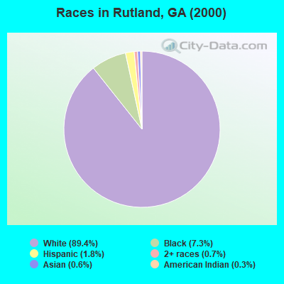
- 9,15189.4%White alone
- 7467.3%Black alone
- 1821.8%Hispanic
- 700.7%Two or more races
- 590.6%Asian alone
- 290.3%American Indian alone
- 20.02%Other race alone
- 10.01%Native Hawaiian and Other
Pacific Islander alone
Races in Rutland detailed stats: ancestries, foreign born residents, place of birth
 Recent articles from our blog. Our writers, many of them Ph.D. graduates or candidates, create easy-to-read articles on a wide variety of topics.
Current Local Time: EST time zone
Elevation: 349 feet
Land area: 40.3 square miles.
Population density: 256 people per square mile (very low).

| Rutland CCD: | 0.8% ($865) |
| Georgia: | 0.9% ($919) |
Nearest city with pop. 50,000+: Macon, GA  (8.5 miles , pop. 97,255).
Nearest city with pop. 200,000+: Atlanta, GA (83.1 miles , pop. 416,474).
Nearest city with pop. 1,000,000+: Chicago, IL (667.8 miles , pop. 2,896,016).
Nearest cities:
), ), Latitude: 32.72 N, Longitude: 83.67 W
Area code commonly used in this area: 478

| Here: | 3.5% |
| Georgia: | 2.9% |
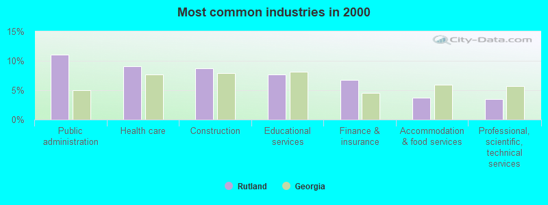
- Public administration (11.1%)
- Health care (9.1%)
- Construction (8.7%)
- Educational services (7.6%)
- Finance & insurance (6.7%)
- Accommodation & food services (3.7%)
- Professional, scientific, technical services (3.4%)
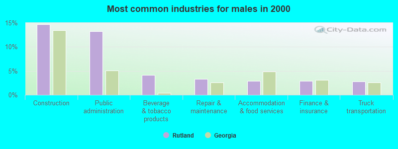
- Construction (14.7%)
- Public administration (13.2%)
- Beverage & tobacco products (4.1%)
- Repair & maintenance (3.3%)
- Accommodation & food services (2.9%)
- Finance & insurance (2.9%)
- Truck transportation (2.8%)
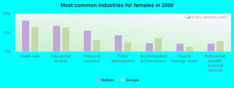
- Health care (16.4%)
- Educational services (13.7%)
- Finance & insurance (11.2%)
- Public administration (8.6%)
- Accommodation & food services (4.6%)
- Food & beverage stores (4.3%)
- Professional, scientific, technical services (4.2%)
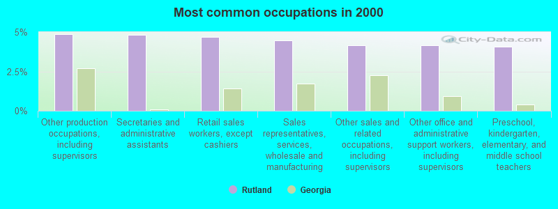
- Other production occupations, including supervisors (4.9%)
- Secretaries and administrative assistants (4.8%)
- Retail sales workers, except cashiers (4.7%)
- Sales representatives, services, wholesale and manufacturing (4.5%)
- Other sales and related occupations, including supervisors (4.2%)
- Other office and administrative support workers, including supervisors (4.1%)
- Preschool, kindergarten, elementary, and middle school teachers (4.1%)
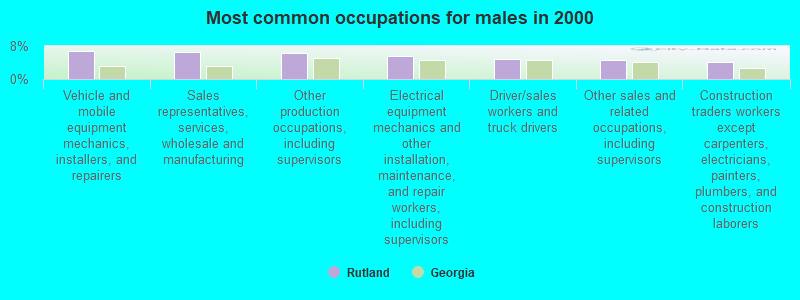
- Vehicle and mobile equipment mechanics, installers, and repairers (6.8%)
- Sales representatives, services, wholesale and manufacturing (6.6%)
- Other production occupations, including supervisors (6.3%)
- Electrical equipment mechanics and other installation, maintenance, and repair workers, including supervisors (5.5%)
- Driver/sales workers and truck drivers (4.9%)
- Other sales and related occupations, including supervisors (4.5%)
- Construction traders workers except carpenters, electricians, painters, plumbers, and construction laborers (4.0%)
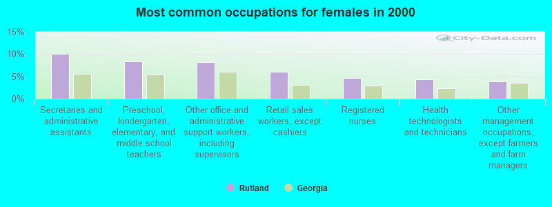
- Secretaries and administrative assistants (10.1%)
- Preschool, kindergarten, elementary, and middle school teachers (8.3%)
- Other office and administrative support workers, including supervisors (8.1%)
- Retail sales workers, except cashiers (6.0%)
- Registered nurses (4.7%)
- Health technologists and technicians (4.3%)
- Other management occupations, except farmers and farm managers (3.9%)
Average climate in Rutland, Georgia
Based on data reported by over 4,000 weather stations


(lower is better)
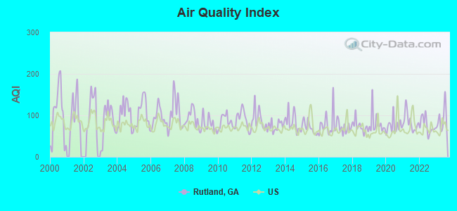
Air Quality Index (AQI) level in 2023 was 90.5. This is worse than average.
| City: | 90.5 |
| U.S.: | 72.6 |
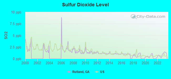
Sulfur Dioxide (SO2) [ppb] level in 2023 was 1.31. This is about average. Closest monitor was 3.9 miles away from the city center.
| City: | 1.31 |
| U.S.: | 1.51 |
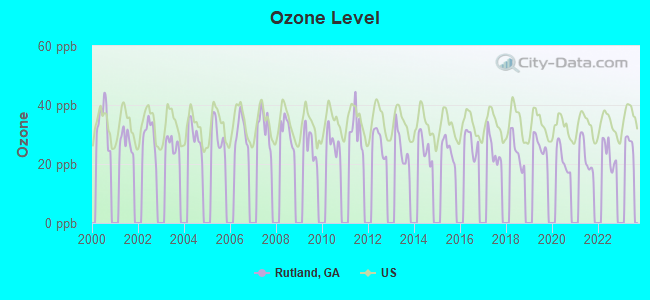
Ozone [ppb] level in 2022 was 23.4. This is significantly better than average. Closest monitor was 9.5 miles away from the city center.
| City: | 23.4 |
| U.S.: | 33.3 |
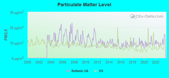
Particulate Matter (PM2.5) [µg/m3] level in 2023 was 11.5. This is significantly worse than average. Closest monitor was 4.2 miles away from the city center.
| City: | 11.5 |
| U.S.: | 8.1 |
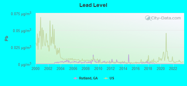
Lead (Pb) [µg/m3] level in 2018 was 0.00153. This is significantly better than average. Closest monitor was 5.8 miles away from the city center.
| City: | 0.00153 |
| U.S.: | 0.00931 |
Tornado activity:
Rutland-area historical tornado activity is near Georgia state average. It is 23% greater than the overall U.S. average.
On 4/30/1953, a category F4 (max. wind speeds 207-260 mph) tornado 9.6 miles away from the Rutland place center killed 18 people and injured 300 people and caused between $5,000,000 and $50,000,000 in damages.
On 3/3/1952, a category F3 (max. wind speeds 158-206 mph) tornado 5.1 miles away from the place center injured 4 people and caused between $50,000 and $500,000 in damages.
Earthquake activity:
Rutland-area historical earthquake activity is significantly above Georgia state average. It is 8% greater than the overall U.S. average.On 8/2/1974 at 08:52:09, a magnitude 4.9 (4.3 MB, 4.9 LG, Class: Light, Intensity: IV - V) earthquake occurred 105.0 miles away from the city center
On 4/29/2003 at 08:59:39, a magnitude 4.9 (4.4 MB, 4.6 MW, 4.9 LG) earthquake occurred 166.3 miles away from the city center
On 4/29/2003 at 08:59:39, a magnitude 4.6 (4.6 MW, Depth: 12.3 mi) earthquake occurred 166.4 miles away from the city center
On 1/18/1999 at 07:00:53, a magnitude 4.8 (4.8 MB, 4.0 LG, Depth: 0.6 mi) earthquake occurred 212.8 miles away from Rutland center
On 10/24/1997 at 08:35:17, a magnitude 4.9 (4.8 MB, 4.2 MS, 4.9 LG, Depth: 6.2 mi) earthquake occurred 238.4 miles away from the city center
On 11/22/1974 at 05:25:55, a magnitude 4.7 (4.7 MB) earthquake occurred 205.6 miles away from the city center
Magnitude types: regional Lg-wave magnitude (LG), body-wave magnitude (MB), surface-wave magnitude (MS), moment magnitude (MW)
Natural disasters:
The number of natural disasters in Bibb County (10) is smaller than the US average (15).Major Disasters (Presidential) Declared: 5
Emergencies Declared: 4
Causes of natural disasters: Floods: 4, Storms: 3, Tornadoes: 3, Tropical Storms: 2, Winter Storms: 2, Drought: 1, Heavy Rain: 1, Hurricane: 1, Snowfall: 1, Other: 1 (Note: some incidents may be assigned to more than one category).
Hospitals and medical centers near Rutland:
- MACON HEALTH CARE CENTER (Nursing Home, about 2 miles away; MACON, GA)
- PORTER FIELD HEALTH AND REHAB CENTER LLC (Nursing Home, about 2 miles away; MACON, GA)
- GOODWILL NH (Nursing Home, about 5 miles away; MACON, GA)
- GOODWILL NURSING HOME INC (Nursing Home, about 5 miles away; MACON, GA)
- BLOOMFIELD NH (Nursing Home, about 6 miles away; MACON, GA)
- CHERRY BLOSSOM HEALTH AND REHABILITATION (Nursing Home, about 6 miles away; MACON, GA)
- CHERRY BLOSSOM HEALTH CARE CENTER INC (Nursing Home, about 6 miles away; MACON, GA)
Colleges/universities with over 2000 students nearest to Rutland:
- Middle Georgia State College (about 7 miles; Macon, GA; Full-time enrollment: 7,091)
- Mercer University (about 8 miles; Macon, GA; FT enrollment: 6,297)
- Central Georgia Technical College (about 13 miles; Warner Robins, GA; FT enrollment: 6,829)
- Fort Valley State University (about 19 miles; Fort Valley, GA; FT enrollment: 3,200)
- Gordon State College (about 36 miles; Barnesville, GA; FT enrollment: 3,336)
- Georgia College and State University (about 36 miles; Milledgeville, GA; FT enrollment: 6,271)
- Georgia Military College-Distance Learning Campuses (about 36 miles; Milledgeville, GA; FT enrollment: 6,438)
Points of interest:
Notable locations in Rutland: Macon - Bibb County Fire Department Station 102 (A), Macon - Bibb County Fire Department Station 107 (B). Display/hide their locations on the map
Churches in Rutland include: New Hope Church (A), Mount Zion Church (B), Avondale Church (C), New Elim Church (D), Sardis Church (E). Display/hide their locations on the map
Cemeteries: Glen Haven Memorial Garden (1), Jones Chapel Cemetery (2). Display/hide their locations on the map
Reservoirs: Bankston Lake (A), Airport Lake (B), Gibson Lake (C), Sikes Lake (D), Attaway Lake (E), Stokes Lake (F). Display/hide their locations on the map
Streams, rivers, and creeks: Johns Branch (A), Echeconnee Creek (B), Coppas Branch (C). Display/hide their locations on the map
| This place: | 2.6 people |
| Georgia: | 2.6 people |
| This place: | 73.9% |
| Whole state: | 68.5% |
| This place: | 5.1% |
| Whole state: | 5.9% |
Likely homosexual households (counted as self-reported same-sex unmarried-partner households)
- Lesbian couples: 0.5% of all households
- Gay men: 0.3% of all households
| This place: | 6.6% |
| Whole state: | 13.0% |
| This place: | 2.7% |
| Whole state: | 6.1% |
6 people in workers' group living quarters and job corps centers in 2010
129 people in nursing homes in 2000
14 people in other group homes in 2000
For population 15 years and over in Rutland:
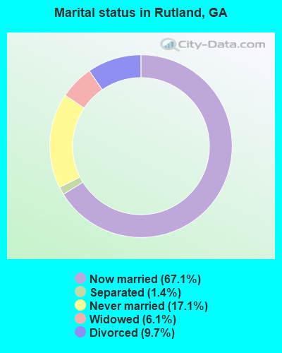
- Never married: 17.1%
- Now married: 67.1%
- Separated: 1.4%
- Widowed: 6.1%
- Divorced: 9.7%
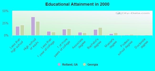
For population 25 years and over in Rutland:
- High school or higher: 81.7%
- Bachelor's degree or higher: 16.8%
- Graduate or professional degree: 4.6%
- Unemployed: 4.2%
- Mean travel time to work (commute): 21.1 minutes
| Here: | 10.1 |
| Georgia average: | 13.3 |
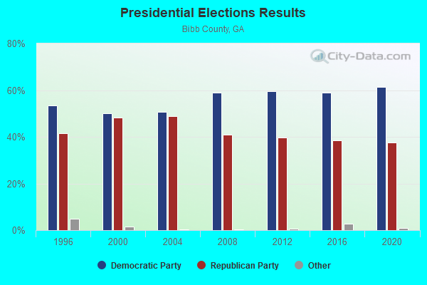
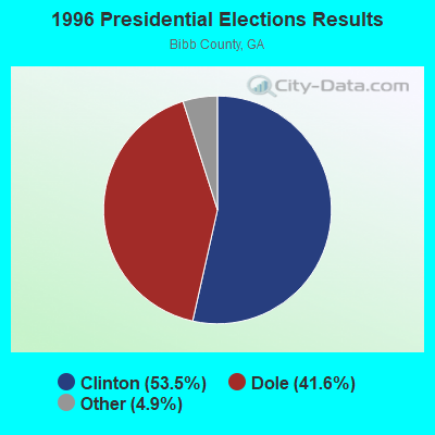
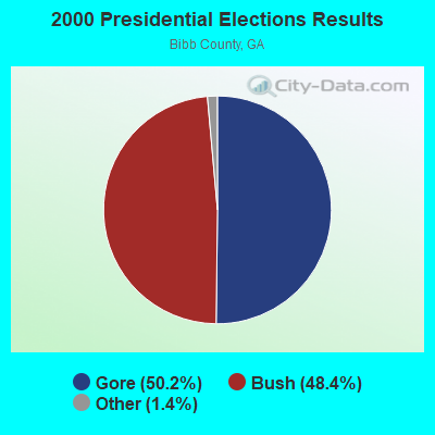
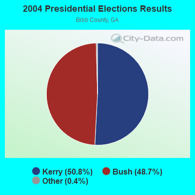
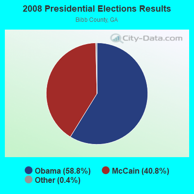
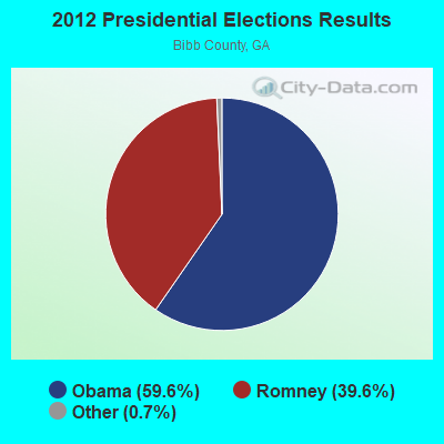
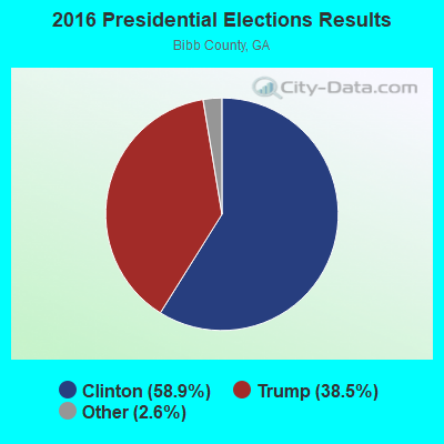
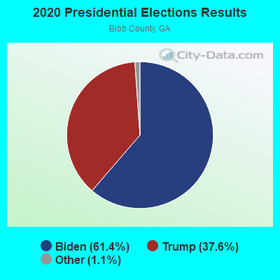
Graphs represent county-level data. Detailed 2008 Election Results
Religion statistics for Rutland, GA (based on Bibb County data)
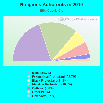
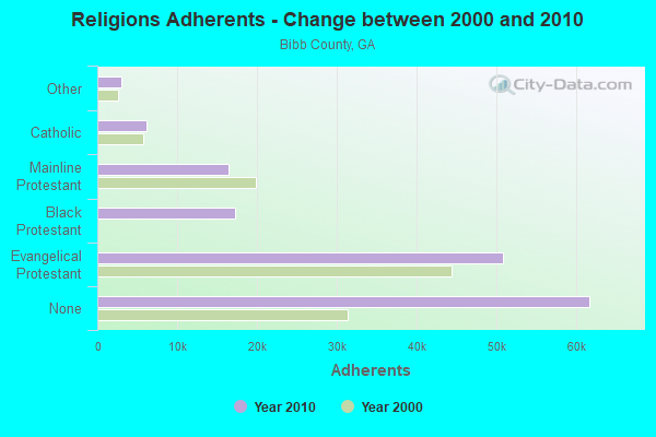
| Religion | Adherents | Congregations |
|---|---|---|
| Evangelical Protestant | 50,855 | 134 |
| Black Protestant | 17,209 | 52 |
| Mainline Protestant | 16,435 | 34 |
| Catholic | 6,153 | 3 |
| Other | 3,006 | 10 |
| Orthodox | 200 | 2 |
| None | 61,689 | - |
Food Environment Statistics:
| This county: | 2.52 / 10,000 pop. |
| Georgia: | 1.91 / 10,000 pop. |
| This county: | 0.19 / 10,000 pop. |
| Georgia: | 0.15 / 10,000 pop. |
| This county: | 1.49 / 10,000 pop. |
| Georgia: | 0.86 / 10,000 pop. |
| Bibb County: | 8.01 / 10,000 pop. |
| Georgia: | 5.12 / 10,000 pop. |
| Here: | 7.82 / 10,000 pop. |
| Georgia: | 7.41 / 10,000 pop. |
| Bibb County: | 12.8% |
| Georgia: | 10.4% |
| Bibb County: | 30.8% |
| Georgia: | 27.8% |
| This county: | 12.1% |
| Georgia: | 14.6% |
Strongest AM radio stations in Rutland:
- WMAC (940 AM; 50 kW; MACON, GA; Owner: CUMULUS LICENSING CORP.)
- WNNG (1350 AM; 15 kW; WARNER ROBINS, GA; Owner: CHASE BROADCASTING, INC.)
- WLCG (1280 AM; 5 kW; MACON, GA)
- WXJO (1120 AM; daytime; 10 kW; GORDON, GA; Owner: ROBERTS COMMUNICATIONS, INC.)
- WPGA (980 AM; 5 kW; PERRY, GA; Owner: RADIO PERRY, INC.)
- WBML (900 AM; 2 kW; MACON, GA; Owner: WBML, INC.)
- WDEN (1500 AM; daytime; 1 kW; MACON, GA; Owner: CUMULUS LICENSING CORP.)
- WDDO (1240 AM; 1 kW; MACON, GA; Owner: CUMULUS LICENSING CORP.)
- WGST (640 AM; 50 kW; ATLANTA, GA; Owner: CITICASTERS LICENSES, L.P.)
- WSB (750 AM; 50 kW; ATLANTA, GA; Owner: CXR HOLDINGS, INC.)
- WNEX (1400 AM; 1 kW; MACON, GA; Owner: RADIO PEACH, INC)
- WGUN (1010 AM; 50 kW; ATLANTA, GA; Owner: WGUN, INC.)
- WCNN (680 AM; 50 kW; NORTH ATLANTA, GA; Owner: DICKEY BROADCASTING COMPANY)
Strongest FM radio stations in Rutland:
- WQBZ (106.3 FM; FORT VALLEY, GA; Owner: CLEVELAND RADIO LICENSES, LLC)
- WAYS (105.5 FM; MACON, GA; Owner: CUMULUS LICENSING CORP.)
- WDEN-FM (99.1 FM; MACON, GA; Owner: CUMULUS LICENSING CORP.)
- WMKS (92.3 FM; MACON, GA; Owner: CUMULUS LICENSING CORP.)
- WBKG (88.9 FM; MACON, GA; Owner: AMERICAN FAMILY ASSOCIATION)
- WRBV (101.7 FM; WARNER ROBINS, GA; Owner: CLEVELAND RADIO LICENSES, LLC)
- WPEZ (93.7 FM; JEFFERSONVILLE, GA; Owner: CUMULUS LICENSING CORP.)
- WIBB-FM (97.9 FM; FORT VALLEY, GA; Owner: CLEVELAND RADIO LICENSES, LLC)
- WJTG (91.3 FM; FORT VALLEY, GA; Owner: JOY PUBLIC B/CNG CORP)
- W202BA (88.3 FM; WARNER ROBINS, GA; Owner: CALVARY CHAPEL OF TWIN FALLS, INC.)
- WPGA-FM (100.9 FM; PERRY, GA; Owner: RADIO PERRY, INC.)
- WELV-FM (102.5 FM; WARNER ROBINS, GA; Owner: CLEVELAND RADIO LICENSES, LLC)
- W282AE (104.3 FM; MACON, GA; Owner: BIBLE BROADCASTING NETWORK, INC.)
- WMGB (95.1 FM; MONTEZUMA, GA; Owner: CUMULUS LICENSING CORP.)
- WYNF (96.5 FM; GRAY, GA; Owner: CLEVELAND RADIO LICENSES, LLC)
- WDCO-FM (89.7 FM; COCHRAN, GA; Owner: GEORGIA PUBLIC TELECOMMUNICATIONS COMMISSION)
- W203BH (88.5 FM; MACON, GA; Owner: CALVARY CHAPEL OF TWIN FALLS, INC.)
- WQMJ (100.1 FM; FORSYTH, GA; Owner: ROBERTS COMMUNICATIONS, INC.)
- WFXM (107.1 FM; GORDON, GA; Owner: ROBERTS COMMUNICATIONS, INC.)
- WPWB (90.5 FM; BYRON, GA; Owner: AUGUSTA RADIO FELLOWSHIP INST., INC.)
TV broadcast stations around Rutland:
- WMGT-TV (Channel 41; MACON, GA; Owner: MORRIS NETWORK, INC.)
- WPGA-TV (Channel 58; PERRY, GA; Owner: RADIO PERRY, INC.)
- WGXA (Channel 24; MACON, GA; Owner: PIEDMONT TELEVISION OF MACON LICENSE LLC)
- WMAZ-TV (Channel 13; MACON, GA; Owner: GANNETT GEORGIA, L.P.)
- WGNM (Channel 64; MACON, GA; Owner: GOOD NEWS TELEVISION)
- WDMA-LP (Channel 32; MACON, GA; Owner: WORD OF GOD FELLOWSHIP, INC.)
- WDCO-TV (Channel 29; COCHRAN, GA; Owner: GEORGIA PUBLIC TELECOMMUNICATIONS COMMISSION)
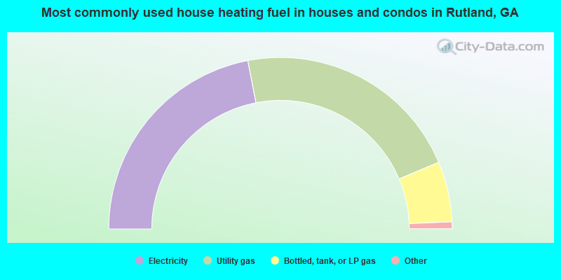
- 43.9%Electricity
- 43.4%Utility gas
- 11.4%Bottled, tank, or LP gas
- 0.8%Wood
- 0.6%Fuel oil, kerosene, etc.
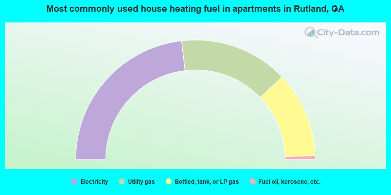
- 46.3%Electricity
- 29.4%Utility gas
- 23.3%Bottled, tank, or LP gas
- 1.0%Fuel oil, kerosene, etc.
Rutland compared to Georgia state average:
- Unemployed percentage significantly below state average.
- Black race population percentage significantly below state average.
- Hispanic race population percentage significantly below state average.
- Foreign-born population percentage significantly below state average.
- Renting percentage below state average.
- Length of stay since moving in significantly above state average.
- Number of rooms per house significantly below state average.
- House age significantly below state average.
- Number of college students below state average.
Rutland on our top lists:
- #4 on the list of "Top 101 cities with largest percentage of males in industries: beverage and tobacco products (population 5,000+)"
- #6 on the list of "Top 101 cities with largest percentage of females in industries: beverage and tobacco products (population 5,000+)"
- #15 on the list of "Top 101 cities with largest percentage of females in industries: lumber and other construction materials merchant wholesalers (population 5,000+)"
- #25 on the list of "Top 101 cities with largest percentage of females in industries: professional and commercial equipment and supplies merchant wholesalers (population 5,000+)"
- #39 on the list of "Top 101 cities with largest percentage of females in industries: jewelry, luggage, and leather goods stores (population 5,000+)"
- #39 on the list of "Top 101 cities with largest percentage of males in industries: machinery, equipment, and supplies merchant wholesalers (population 5,000+)"
- #45 on the list of "Top 101 cities with largest percentage of females in industries: used merchandise, gift, novelty, and souvenir, and other miscellaneous stores (population 5,000+)"
- #46 on the list of "Top 101 cities with largest percentage of males in occupations: vehicle and mobile equipment mechanics, installers, and repairers (population 5,000+)"
- #50 on the list of "Top 101 cities with the largest percentage of high school students in private schools (500+ students)"
- #57 on the list of "Top 101 cities with largest percentage of males in industries: miscellaneous durable goods merchant wholesalers (population 5,000+)"
- #57 on the list of "Top 101 cities with largest percentage of males in industries: motor vehicles, parts and supplies merchant wholesalers (population 5,000+)"
- #58 on the list of "Top 101 cities with largest percentage of males in industries: retail florists (population 5,000+)"
- #59 on the list of "Top 101 cities with largest percentage of males in occupations: religious workers (population 5,000+)"
- #59 on the list of "Top 101 cities with largest percentage of males in industries: drugs, sundries, and chemical and allied products merchant wholesalers (population 5,000+)"
- #60 on the list of "Top 101 cities with largest percentage of females in occupations: business operations specialists (population 5,000+)"
- #61 on the list of "Top 101 cities with largest percentage of females in occupations: secretaries and administrative assistants (population 5,000+)"
- #66 on the list of "Top 101 cities with largest percentage of females in occupations: retail sales workers except cashiers (population 5,000+)"
- #66 on the list of "Top 101 cities with largest percentage of males in occupations: sales representatives, services, wholesale and manufacturing (population 5,000+)"
- #76 on the list of "Top 101 cities with largest percentage of females in industries: nonmetallic mineral products (population 5,000+)"
- #82 on the list of "Top 101 cities with largest percentage of females in industries: electrical and electronic goods merchant wholesalers (population 5,000+)"
- #10 on the list of "Top 101 counties with the lowest lead air pollution readings in 2012 (µg/m3)"
- #22 on the list of "Top 101 counties with the highest lead air pollution readings in 2012 (µg/m3)"
- #33 on the list of "Top 101 counties with the smallest number of children under 18 without health insurance coverage in 2000 (pop. 50,000+)"
- #49 on the list of "Top 101 counties with the smallest number of people without health insurance coverage in 2000 (pop. 50,000+)"
- #50 on the list of "Top 101 counties with the highest number of births per 1000 residents 2007-2013"