Savoy, Massachusetts
Submit your own pictures of this town and show them to the world
Detailed information about poverty and poor residents in Savoy, MA
 Recent articles from our blog. Our writers, many of them Ph.D. graduates or candidates, create easy-to-read articles on a wide variety of topics.
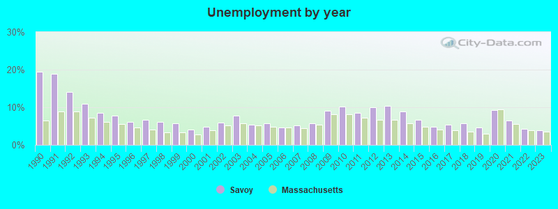
| Here: | 3.8% |
| Massachusetts: | 3.5% |
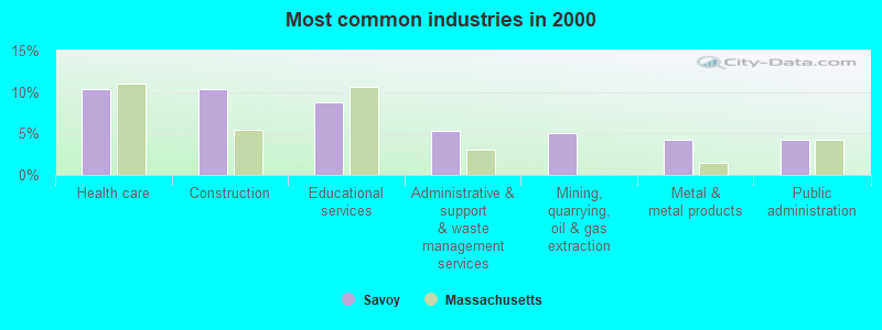
- Health care (10.4%)
- Construction (10.4%)
- Educational services (8.7%)
- Administrative & support & waste management services (5.3%)
- Mining, quarrying, oil & gas extraction (5.1%)
- Metal & metal products (4.2%)
- Public administration (4.2%)
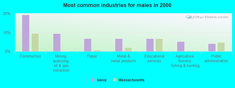
- Construction (19.4%)
- Mining, quarrying, oil & gas extraction (9.4%)
- Paper (6.8%)
- Metal & metal products (6.8%)
- Educational services (6.8%)
- Agriculture, forestry, fishing & hunting (5.2%)
- Public administration (4.2%)
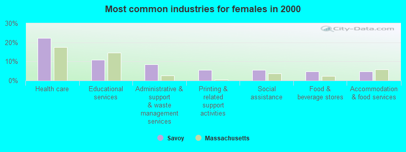
- Health care (22.4%)
- Educational services (10.9%)
- Administrative & support & waste management services (8.5%)
- Printing & related support activities (5.5%)
- Social assistance (5.5%)
- Food & beverage stores (4.8%)
- Accommodation & food services (4.8%)
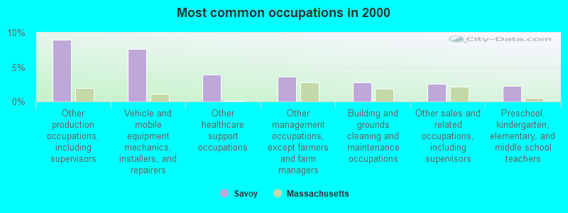
- Other production occupations, including supervisors (9.0%)
- Vehicle and mobile equipment mechanics, installers, and repairers (7.6%)
- Other healthcare support occupations (3.9%)
- Other management occupations, except farmers and farm managers (3.7%)
- Building and grounds cleaning and maintenance occupations (2.8%)
- Other sales and related occupations, including supervisors (2.5%)
- Preschool, kindergarten, elementary, and middle school teachers (2.2%)
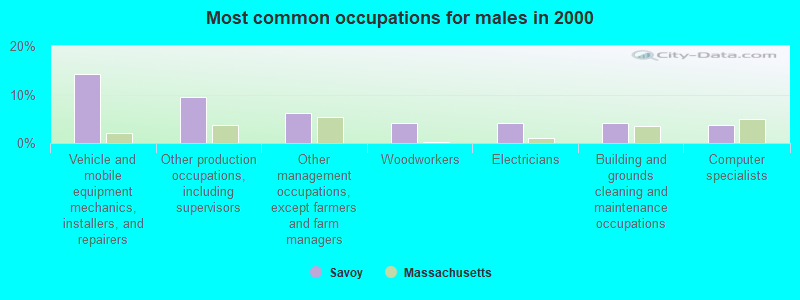
- Vehicle and mobile equipment mechanics, installers, and repairers (14.1%)
- Other production occupations, including supervisors (9.4%)
- Other management occupations, except farmers and farm managers (6.3%)
- Woodworkers (4.2%)
- Electricians (4.2%)
- Building and grounds cleaning and maintenance occupations (4.2%)
- Computer specialists (3.7%)
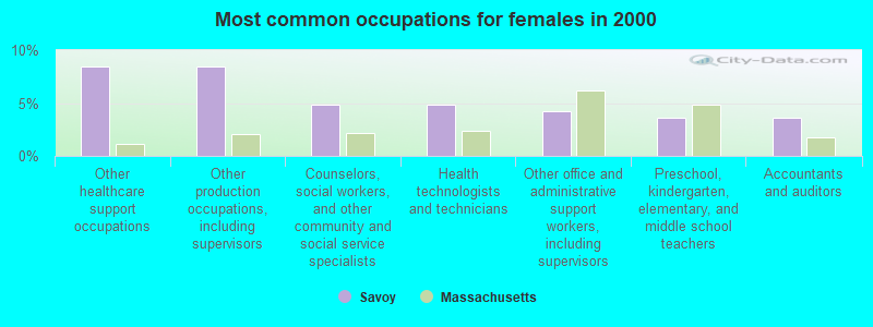
- Other healthcare support occupations (8.5%)
- Other production occupations, including supervisors (8.5%)
- Counselors, social workers, and other community and social service specialists (4.8%)
- Health technologists and technicians (4.8%)
- Other office and administrative support workers, including supervisors (4.2%)
- Preschool, kindergarten, elementary, and middle school teachers (3.6%)
- Accountants and auditors (3.6%)
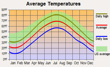
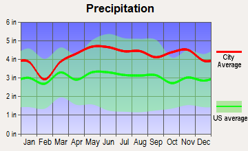
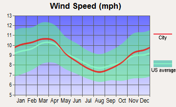
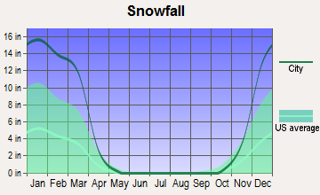
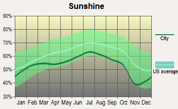
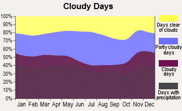
Average climate in Savoy, Massachusetts
Based on data reported by over 4,000 weather stations

(lower is better)
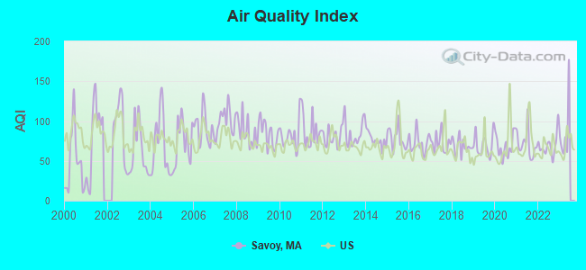
Air Quality Index (AQI) level in 2022 was 69.4. This is about average.
| City: | 69.4 |
| U.S.: | 72.6 |
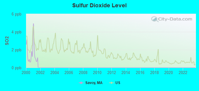
Sulfur Dioxide (SO2) [ppb] level in 2001 was 1.71. This is about average. Closest monitor was 8.4 miles away from the city center.
| City: | 1.71 |
| U.S.: | 1.51 |
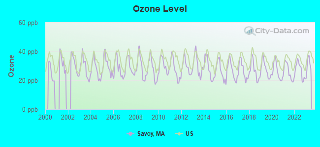
Ozone [ppb] level in 2022 was 26.8. This is better than average. Closest monitor was 13.7 miles away from the city center.
| City: | 26.8 |
| U.S.: | 33.3 |
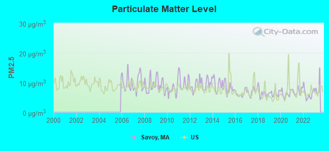
Particulate Matter (PM2.5) [µg/m3] level in 2022 was 6.17. This is better than average. Closest monitor was 9.1 miles away from the city center.
| City: | 6.17 |
| U.S.: | 8.11 |
Tornado activity:
Savoy-area historical tornado activity is slightly above Massachusetts state average. It is 20% smaller than the overall U.S. average.
On 8/28/1973, a category F4 (max. wind speeds 207-260 mph) tornado 24.0 miles away from the Savoy town center killed 4 people and injured 36 people and caused between $5,000,000 and $50,000,000 in damages.
On 5/29/1995, a category F4 tornado 30.3 miles away from the town center killed 3 people and injured 24 people and caused between $5,000,000 and $50,000,000 in damages.
Earthquake activity:
Savoy-area historical earthquake activity is significantly above Massachusetts state average. It is 69% smaller than the overall U.S. average.On 10/7/1983 at 10:18:46, a magnitude 5.3 (5.1 MB, 5.3 LG, 5.1 ML, Class: Moderate, Intensity: VI - VII) earthquake occurred 115.5 miles away from Savoy center
On 4/20/2002 at 10:50:47, a magnitude 5.3 (5.3 ML, Depth: 3.0 mi) earthquake occurred 137.2 miles away from Savoy center
On 4/20/2002 at 10:50:47, a magnitude 5.2 (5.2 MB, 4.2 MS, 5.2 MW, 5.0 MW) earthquake occurred 135.7 miles away from Savoy center
On 1/19/1982 at 00:14:42, a magnitude 4.7 (4.5 MB, 4.7 MD, 4.5 LG, Class: Light, Intensity: IV - V) earthquake occurred 95.0 miles away from Savoy center
On 10/16/2012 at 23:12:25, a magnitude 4.7 (4.7 ML, Depth: 10.0 mi) earthquake occurred 137.8 miles away from Savoy center
On 6/17/1991 at 08:53:16, a magnitude 4.1 (4.0 MB, 4.0 LG, Depth: 3.1 mi) earthquake occurred 84.9 miles away from Savoy center
Magnitude types: regional Lg-wave magnitude (LG), body-wave magnitude (MB), duration magnitude (MD), local magnitude (ML), surface-wave magnitude (MS), moment magnitude (MW)
Natural disasters:
The number of natural disasters in Berkshire County (21) is greater than the US average (15).Major Disasters (Presidential) Declared: 10
Emergencies Declared: 10
Causes of natural disasters: Floods: 5, Snowstorms: 5, Storms: 5, Hurricanes: 4, Winter Storms: 4, Blizzards: 2, Snows: 2, Snowfall: 1, Tropical Storm: 1, Wind: 1, Other: 1 (Note: some incidents may be assigned to more than one category).

Hospitals and medical centers near Savoy:
- NORTHERN BERKSHIRE COMPREHENSIVE CARE (Home Health Center, about 7 miles away; ADAMS, MA)
- HOSPICE OF N BERKSHIRE INC (Hospital, about 7 miles away; ADAMS, MA)
- NORTH ADAMS COMMONS NURSING AND REHABILITATION CENTE (Nursing Home, about 10 miles away; NORTH ADAMS, MA)
- ADAMS N H OF N ADAMS (Nursing Home, about 10 miles away; NORTH ADAMS, MA)
- NORTH ADAMS REGIONAL HOSPITAL Acute Care Hospitals (about 10 miles away; NORTH ADAMS, MA)
- WILLIAMSTOWN COMMONS NURSING AND REHAB (Nursing Home, about 12 miles away; WILLIAMSTOWN, MA)
- CRANEVILLE PLACE AT DALTON (Nursing Home, about 12 miles away; DALTON, MA)
Colleges/universities with over 2000 students nearest to Savoy:
- Williams College (about 13 miles; Williamstown, MA; Full-time enrollment: 2,141)
- Smith College (about 27 miles; Northampton, MA; FT enrollment: 3,549)
- University of Massachusetts-Amherst (about 29 miles; Amherst, MA; FT enrollment: 26,583)
- Mount Holyoke College (about 33 miles; South Hadley, MA; FT enrollment: 2,573)
- Holyoke Community College (about 34 miles; Holyoke, MA; FT enrollment: 4,911)
- Westfield State University (about 34 miles; Westfield, MA; FT enrollment: 5,548)
- Hudson Valley Community College (about 35 miles; Troy, NY; FT enrollment: 9,346)
Points of interest:
Notable location: Savoy Fire Department (A). Display/hide its location on the map
Cemeteries: New State Cemetery (1), Brier Cemetery (2), New State Cemetery (3), The Tomb Cemetery (4). Display/hide their locations on the map
Lakes, reservoirs, and swamps: South Pond (A), Tannery Pond (B), Bog Pond (C), Burnett Pond (D), Tyler Pond (E). Display/hide their locations on the map
Streams, rivers, and creeks: Tilton Brook (A), Tannery Brook (B), Horsefords Brook (C), Brown Brook (D), Black Brook (E), Savoy Hollow Brook (F), Ross Brook (G), Parker Brook (H), Drowned Land Brook (I). Display/hide their locations on the map
Birthplace of: Duane Leroy Bliss - Businessman.
| This town: | 2.3 people |
| Massachusetts: | 2.5 people |
| This town: | 65.1% |
| Whole state: | 63.0% |
| This town: | 9.4% |
| Whole state: | 7.0% |
Likely homosexual households (counted as self-reported same-sex unmarried-partner households)
- Lesbian couples: 0.7% of all households
- Gay men: 1.7% of all households
| This town: | 5.4% |
| Whole state: | 9.3% |
| This town: | 1.2% |
| Whole state: | 4.4% |
| Here: | 10.0 |
| Massachusetts average: | 13.1 |


Graphs represent county-level data. Detailed 2008 Election Results
Religion statistics for Savoy, MA (based on Berkshire County data)


| Religion | Adherents | Congregations |
|---|---|---|
| Catholic | 50,187 | 32 |
| Mainline Protestant | 9,895 | 63 |
| Other | 3,647 | 20 |
| Evangelical Protestant | 2,817 | 28 |
| Black Protestant | 233 | 2 |
| Orthodox | 225 | 2 |
| None | 64,215 | - |
Food Environment Statistics:
| This county: | 2.54 / 10,000 pop. |
| Massachusetts: | 1.98 / 10,000 pop. |
| Berkshire County: | 1.61 / 10,000 pop. |
| Massachusetts: | 2.22 / 10,000 pop. |
| Berkshire County: | 4.08 / 10,000 pop. |
| State: | 1.77 / 10,000 pop. |
| Berkshire County: | 15.00 / 10,000 pop. |
| Massachusetts: | 8.76 / 10,000 pop. |
| This county: | 8.0% |
| State: | 8.1% |
| Berkshire County: | 22.8% |
| Massachusetts: | 22.5% |
| Berkshire County: | 9.9% |
| Massachusetts: | 16.5% |
Strongest AM radio stations in Savoy:
- WNNZ (640 AM; 50 kW; WESTFIELD, MA; Owner: CLEAR CHANNEL BROADCASTING LICENSES, INC.)
- WGY (810 AM; 50 kW; SCHENECTADY, NY; Owner: CLEAR CHANNEL BROADCASTING LICENSES, INC.)
- WPTR (1540 AM; 50 kW; ALBANY, NY; Owner: KIMTRON, INC.)
- WCRN (830 AM; 50 kW; WORCESTER, MA; Owner: CARTER BROADCASTING CORPORATION)
- WIZZ (1520 AM; daytime; 10 kW; GREENFIELD, MA; Owner: P. & M. RADIO, LLC)
- WUHN (1110 AM; daytime; 5 kW; PITTSFIELD, MA; Owner: WEINER BROADCASTING, INC.)
- WTIC (1080 AM; 50 kW; HARTFORD, CT; Owner: INFINITY RADIO OPERATIONS INC.)
- WNAW (1230 AM; 1 kW; NORTH ADAMS, MA; Owner: BERKSHIRE BROADCASTING CO., INC.)
- WVNE (760 AM; daytime; 25 kW; LEICESTER, MA; Owner: BLOUNT MASSCOM, INC.)
- WRKO (680 AM; 50 kW; BOSTON, MA; Owner: ENTERCOM BOSTON LICENSE, LLC)
- WHYN (560 AM; 5 kW; SPRINGFIELD, MA; Owner: CLEAR CHANNEL BROADCASTING LICENSES, INC.)
- WALE (990 AM; 50 kW; GREENVILLE, RI; Owner: NORTH AMERICAN BROADCASTING CO., INC.)
- WEEI (850 AM; 50 kW; BOSTON, MA; Owner: ENTERCOM BOSTON LICENSE, LLC)
Strongest FM radio stations in Savoy:
- WAMC-FM (90.3 FM; ALBANY, NY; Owner: WAMC)
- WMNB (100.1 FM; NORTH ADAMS, MA; Owner: BERKSHIRE BROADCASTING CO., INC.)
- WVAY (100.7 FM; WILMINGTON, VT; Owner: GREAT NORTHERN RADIO, L.L.C.)
- WEQX (102.7 FM; MANCHESTER, VT; Owner: NORTHSHIRE COMMUNICATIONS, INC.)
- WJAN (95.1 FM; SUNDERLAND, VT; Owner: 6 JOHNSON ROAD LICENSES, INC.)
- WZEC (97.5 FM; HOOSICK FALLS, NY; Owner: GREAT NORTHERN RADIO, LLC)
- WPVQ (95.3 FM; GREENFIELD, MA; Owner: GREAT NORTHERN RADIO, L.L.C.)
- WBEC-FM (105.5 FM; PITTSFIELD, MA; Owner: GREAT NORTHERN RADIO, LLC)
- WUPE (95.9 FM; PITTSFIELD, MA; Owner: WEINER BROADCASTING, INC.)
- WRSY (101.5 FM; MARLBORO, VT; Owner: GREAT NORTHERN RADIO, L.L.C.)
- WHVP (91.1 FM; HUDSON, NY; Owner: SOUND OF LIFE, INC.)
- WHYN-FM (93.1 FM; SPRINGFIELD, MA; Owner: CLEAR CHANNEL BROADCASTING LICENSES, INC.)
- WRNX (100.9 FM; AMHERST, MA; Owner: WESTERN MASSACHUSETTS RADIO COMPANY)
- WJJR (98.1 FM; RUTLAND, VT; Owner: 6 JOHNSON ROAD LICENSES, INC.)
- WZRT (97.1 FM; RUTLAND, VT; Owner: CAPSTAR TX LIMITED PARTNERSHIP)
- WFCR (88.5 FM; AMHERST, MA; Owner: UNIVERSITY OF MASSACHUSETTS)
- WHAI (98.3 FM; GREENFIELD, MA; Owner: SAGA COMMUNICATIONS OF NEW ENGLAND, LLC)
- WHDQ (106.1 FM; CLAREMONT, NH; Owner: GREAT NORTHERN RADIO, L.L.C.)
- WVPR (89.5 FM; WINDSOR, VT; Owner: VERMONT PUBLIC RADIO)
- WRSI (93.9 FM; TURNERS FALLS, MA; Owner: GREAT NORTHERN RADIO, LLC)
TV broadcast stations around Savoy:
- WCDC-TV (Channel 19; ADAMS, MA; Owner: YOUNG BROADCASTING OF ALBANY, INC.)
- W35BK (Channel 35; PLAINFIELD, MA; Owner: LYDIA SYLVANE STOCKWELL)
- W38DL (Channel 38; ADAMS, ETC., MA; Owner: WNYT-TV, LLC)
Savoy fatal accident list:
Nov 4, 2005 03:19 PM, Sr-2, Lat: 42.694960, Lon: -73.042400, Vehicles: 1, Persons: 1, Fatalities: 1
Nov 1, 2004 03:00 PM, Sr-116, Vehicles: 1, Persons: 1, Fatalities: 1
- National Bridge Inventory (NBI) Statistics
- 14Number of bridges
- 52ft / 16.2mTotal length
- $10,632,000Total costs
- 9,790Total average daily traffic
- 1,396Total average daily truck traffic
- 11,300Total future (year 2031) average daily traffic
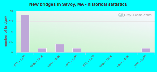
- New bridges - historical statistics
- 91930-1939
- 11940-1949
- 21950-1959
- 11960-1969
- 12000-2009
FCC Registered Cell Phone Towers:
1- 215 Windsor Rd (98482) (Lat: 42.554528 Lon: -73.038611), Type: Mtower, Structure height: 45.7 m, Overall height: 46.6 m, Call Sign: KNKA666
Assigned Frequencies: 880.020 MHz, 880.020 MHz, 880.020 MHz, 835.020 MHz, 835.020 MHz, 835.020 MHz, 891.510 MHz, 891.510 MHz, 891.510 MHz, 846.510 MHz, 846.510 MHz, 846.510 MHzGrant Date: 09/05/2018, Expiration Date: 10/01/2028, Certifier: Michael P GogginRegistrant: At&t Services, Inc., 208 S Akard St, 20f, Dallas, TX 75202, Phone: (855) 699-7073, Fax: (214) 746-6410, Email:
FCC Registered Broadcast Land Mobile Towers:
1- Borden Mountain (Lat: 42.600083 Lon: -73.027611), Type: Tower, Structure height: 33 m, Call Sign: WPMZ626,
Assigned Frequencies: 33.4800 MHz, 33.5400 MHz, 33.8600 MHz, Grant Date: 04/13/1999, Expiration Date: 04/13/2004, Cancellation Date: 06/13/2004, Certifier: John Taylor, Registrant: Motorola Inc, 9 Hazelnut Ln, Londonderry, NH 03053, Fax: (603) 434-0070
FCC Registered Microwave Towers:
7- 2.5 Mi N Of (Lat: 42.600083 Lon: -73.027583), Overall height: 33.2 m, Call Sign: WNTZ232,
Assigned Frequencies: 6730.62 MHz, Grant Date: 06/13/1995, Expiration Date: 06/13/2000, Cancellation Date: 09/24/2000, Phone: (617) 935-3424
- SAVOY, 2.5 Mi N Of (Lat: 42.600083 Lon: -73.027611), Type: Mast, Structure height: 33.2 m, Call Sign: WPXE364,
Assigned Frequencies: 6731.25 MHz, 6775.00 MHz, 10621.2 MHz, Grant Date: 02/22/2023, Expiration Date: 03/17/2033, Certifier: Linda Dunlevy, Registrant: Franklin Regional Council Of Governments, 12 Olive St Ste 2, Greenfield, MA 01301-3351, Phone: (413) 774-3167, Fax: (413) 774-3169, Email:
- BORDEN MTN, Tower Road (Lat: 42.600083 Lon: -73.027333), Type: Tower, Structure height: 30.5 m, Overall height: 33.5 m, Call Sign: WQDH236,
Assigned Frequencies: 6595.00 MHz, 957.550 MHz, 957.150 MHz, 934.375 MHz, Grant Date: 08/24/2005, Expiration Date: 08/24/2015, Cancellation Date: 10/24/2015, Certifier: Russell Sienkiewcz, Registrant: Cromack Industries, Inc., 22 Rockland Rd, Greenfield, MA 01302, Phone: (413) 774-6500, Email:
- Borden Mtn., Tower Road, Off Adams Rd. (Lat: 42.600222 Lon: -73.027500), Type: Tower, Structure height: 32.9 m, Overall height: 38 m, Call Sign: WQGV326,
Assigned Frequencies: 6078.62 MHz, 6212.06 MHz, 6695.00 MHz, 6655.00 MHz, Grant Date: 01/26/2017, Expiration Date: 04/24/2027, Certifier: John Nachilly, Registrant: Micronet Communications, Inc., 812 Lexington Dr, Plano, TX 75075, Phone: (972) 422-7200, Email:
- SAVOY, Cory Road Fire Lookout Twr (Lat: 42.600361 Lon: -73.029556), Type: Tower, Structure height: 30.5 m, Overall height: 31 m, Call Sign: WQHU379,
Assigned Frequencies: 958.350 MHz, Grant Date: 11/07/2007, Expiration Date: 11/07/2017, Cancellation Date: 01/13/2018, Certifier: William Brown, Registrant: Cromack Industries, Inc., Greenfield, MA 01302, Phone: (413) 774-6513, Email:
- BORDEN MTN, Tower Rd, Sw Of The Intersection Of Adams Rd And Bannis Rd 2.7 Mi N Of (Lat: 42.601194 Lon: -73.027611), Type: Mast, Structure height: 18.3 m, Overall height: 21.9 m, Call Sign: WQNC842,
Assigned Frequencies: 11385.0 MHz, 11265.0 MHz, 11585.0 MHz, 10603.1 MHz, 6625.00 MHz, 10643.1 MHz, 10627.5 MHz, Grant Date: 09/29/2020, Expiration Date: 12/21/2030, Certifier: Charles B Sutherland, Registrant: Massachusetts, Commonwealth Of, 470 Worcester Rd, Framingham, MA 01702, Phone: (508) 820-2264, Email:
- BORDEN SAVOY, End Of Tower Road (Lat: 42.601194 Lon: -73.027611), Type: Ltower, Structure height: 22.9 m, Call Sign: WRFL549, Licensee ID: L00758938,
Assigned Frequencies: 11445.0 MHz, 11445.0 MHz, 11445.0 MHz, 11445.0 MHz, 11445.0 MHz, 11445.0 MHz, 11445.0 MHz, 11445.0 MHz, Grant Date: 03/24/2020, Expiration Date: 03/24/2030, Certifier: Thomas Grady, Registrant: Berkshire County Sheriffs Office, 467 Cheshire Road, Pittsfield, MA 01201, Phone: (413) 447-7117, Fax: (413) 448-5328, Email:
FCC Registered Amateur Radio Licenses:
9 (See the full list of FCC Registered Amateur Radio Licenses in Savoy)FAA Registered Aircraft:
1- Aircraft: CESSNA 177RG (Category: Land, Seats: 4, Weight: Up to 12,499 Pounds, Speed: 120 mph), Engine: LYCOMING IO-360-A1B6D (200 HP) (Reciprocating)
N-Number: 8255G, N8255G, N-8255G, Serial Number: 177RG0155, Year manufactured: 1971, Airworthiness Date: 04/23/1971, Certificate Issue Date: 06/16/2008
Registrant (Individual): John Bromback, 1107 Main Rd, Savoy, MA 01256
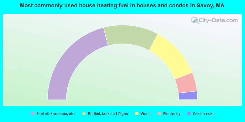
- 41.8%Fuel oil, kerosene, etc.
- 23.9%Bottled, tank, or LP gas
- 22.4%Wood
- 8.2%Electricity
- 3.7%Coal or coke
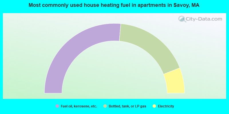
- 52.9%Fuel oil, kerosene, etc.
- 35.3%Bottled, tank, or LP gas
- 11.8%Electricity
Savoy compared to Massachusetts state average:
- Median house value below state average.
- Unemployed percentage significantly below state average.
- Black race population percentage significantly below state average.
- Hispanic race population percentage significantly below state average.
- Median age above state average.
- Foreign-born population percentage significantly below state average.
- Renting percentage significantly below state average.
- Length of stay since moving in significantly above state average.
- Number of rooms per house significantly below state average.
- House age significantly below state average.
- Number of college students below state average.
- Percentage of population with a bachelor's degree or higher below state average.