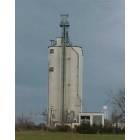
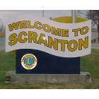
Scranton, Kansas
Submit your own pictures of this city and show them to the world
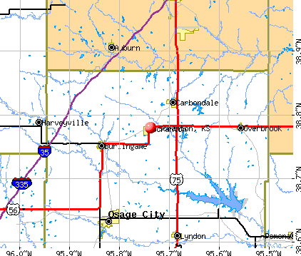
- OSM Map
- General Map
- Google Map
- MSN Map
Population change since 2000: -11.0%
 |
| Males: 286 | |
| Females: 358 |
| Median resident age: | 40.1 years |
| Kansas median age: | 37.6 years |
Zip codes: 66537.
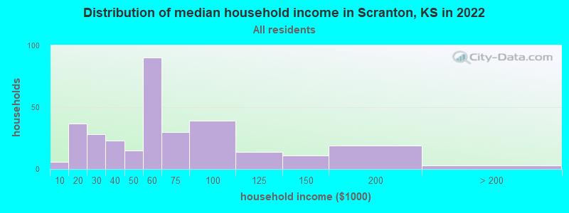
| Scranton: | $50,877 |
| KS: | $68,925 |
Estimated per capita income in 2022: $25,052 (it was $15,210 in 2000)
Scranton city income, earnings, and wages data
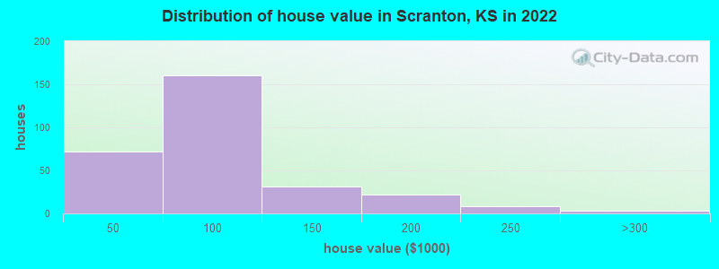
Estimated median house or condo value in 2022: $71,595 (it was $45,300 in 2000)
| Scranton: | $71,595 |
| KS: | $206,600 |
Mean prices in 2022: all housing units: $85,657; detached houses: $91,979; mobile homes: $43,525
Median gross rent in 2022: $551.
(20.9% for White Non-Hispanic residents, 6.2% for two or more races residents)
Detailed information about poverty and poor residents in Scranton, KS

Compare current foreclosures near Scranton, KS:
| Photo | Address | Area | Beds / Baths | Price | Details |
|---|---|---|---|---|---|

|
#1
W 157th St
Scranton, KS 66537
|
924 sq. feet
|
4 baths 6 beds |
show details | |

|
#2
W North St # 9
Scranton, KS 66537
|
- sq. feet
|
- baths - beds |
show details | |

|
#3
S Adams Rd
Scranton, KS 66537
|
- sq. feet
|
- baths - beds |
show details | |

|
#4
SE California Ave
Topeka, KS 66609
|
1,590 sq. feet
|
2 baths 3 beds |
$149,900
|
show details |

|
#5
SW Wood Valley Dr
Topeka, KS 66610
|
2,248 sq. feet
|
2 baths 3 beds |
show details | |

|
#6
Kellogg Ln
Auburn, KS 66402
|
1,742 sq. feet
|
2 baths 3 beds |
show details | |

|
#7
N Norris St
Carbondale, KS 66414
|
960 sq. feet
|
1 baths 3 beds |
show details | |

|
#8
SE 53rd St
Berryton, KS 66409
|
1,472 sq. feet
|
2 baths 3 beds |
show details | |

|
#9
Melody Ln
Vassar, KS 66543
|
1,316 sq. feet
|
2 baths 2 beds |
show details | |

|
#10
SW Twilight Dr
Topeka, KS 66614
|
1,144 sq. feet
|
1 baths 3 beds |
show details |
| Photo | Address | Area | Beds / Baths | Price | Details |
|---|---|---|---|---|---|

|
#11
SE Truman Ct
Topeka, KS 66605
|
816 sq. feet
|
1 baths 2 beds |
show details | |

|
#12
SW Commanche Rd
Topeka, KS 66614
|
1,242 sq. feet
|
2 baths 3 beds |
show details | |

|
#13
SW Twilight Dr
Topeka, KS 66614
|
1,171 sq. feet
|
1 baths 3 beds |
show details | |

|
#14
SE 37th St
Topeka, KS 66605
|
1,196 sq. feet
|
1 baths 3 beds |
show details | |

|
#15
SE Virginia Ave
Topeka, KS 66605
|
1,674 sq. feet
|
1 baths 3 beds |
show details | |

|
#16
SW Twilight Dr
Topeka, KS 66614
|
1,148 sq. feet
|
2 baths 3 beds |
show details | |

|
#17
SE 36th Ter
Topeka, KS 66605
|
775 sq. feet
|
1 baths 3 beds |
show details | |

|
#18
SW Arrowhead Rd
Topeka, KS 66614
|
1,470 sq. feet
|
1 baths 3 beds |
show details | |

|
#19
SW 33rd St
Topeka, KS 66611
|
1,280 sq. feet
|
3 baths 3 beds |
show details | |

|
#20
SE Kentucky Ave
Topeka, KS 66605
|
1,021 sq. feet
|
1 baths 3 beds |
show details |
| Photo | Address | Area | Beds / Baths | Price | Details |
|---|---|---|---|---|---|

|
#21
SW Westwood Ct
Topeka, KS 66614
|
1,244 sq. feet
|
2 baths 3 beds |
show details | |

|
#22
SE Powell Ct
Topeka, KS 66609
|
1,158 sq. feet
|
3 baths 3 beds |
show details | |

|
#23
SW Clontarf St
Topeka, KS 66611
|
1,100 sq. feet
|
1 baths 3 beds |
show details | |

|
#24
SW 32nd Ter
Topeka, KS 66611
|
2,017 sq. feet
|
2 baths 4 beds |
show details | |

|
#25
SW Clare Ave
Topeka, KS 66611
|
1,030 sq. feet
|
1 baths 3 beds |
show details | |

|
#26
SW Westwood Dr
Topeka, KS 66614
|
816 sq. feet
|
2 baths 4 beds |
show details | |

|
#27
SW 34th Ter
Topeka, KS 66614
|
1,072 sq. feet
|
2 baths 3 beds |
show details | |

|
#28
SW Harp Pl
Topeka, KS 66611
|
980 sq. feet
|
1 baths 2 beds |
show details | |

|
#29
SE Oakwood Ct
Topeka, KS 66609
|
3,354 sq. feet
|
3 baths 5 beds |
show details | |

|
#30
SE Minnesota Ave
Topeka, KS 66609
|
1,273 sq. feet
|
3 baths 3 beds |
show details |
| Photo | Address | Area | Beds / Baths | Price | Details |
|---|---|---|---|---|---|

|
#31
SW 40th Ter
Topeka, KS 66609
|
925 sq. feet
|
2 baths 3 beds |
show details | |

|
#32
SW Gamwell Rd
Topeka, KS 66610
|
2,669 sq. feet
|
3 baths 3 beds |
show details | |

|
#33
SE 43rd St
Topeka, KS 66609
|
1,234 sq. feet
|
2 baths 3 beds |
show details | |

|
#34
SE Oakridge Ln
Topeka, KS 66609
|
2,459 sq. feet
|
3 baths 3 beds |
show details | |

|
#35
SW Moundview
Topeka, KS 66610
|
1,767 sq. feet
|
2 baths 3 beds |
show details | |

|
#36
SE Truman Ave
Topeka, KS 66609
|
850 sq. feet
|
1 baths 2 beds |
show details | |

|
#37
SE 43rd Ter
Topeka, KS 66609
|
1,355 sq. feet
|
2 baths 2 beds |
show details | |

|
#38
SW Nottingham Rd
Topeka, KS 66610
|
1,386 sq. feet
|
3 baths 3 beds |
show details | |

|
#39
SW Glendale Dr
Topeka, KS 66614
|
1,936 sq. feet
|
2 baths 3 beds |
show details | |

|
#40
SW Suffolk Rd
Topeka, KS 66610
|
1,544 sq. feet
|
2 baths 3 beds |
show details |
| Photo | Address | Area | Beds / Baths | Price | Details |
|---|---|---|---|---|---|

|
#41
SW Kiowa St
Topeka, KS 66610
|
1,400 sq. feet
|
2 baths 3 beds |
show details | |

|
#42
SW Glendale Dr
Topeka, KS 66614
|
1,494 sq. feet
|
3 baths 4 beds |
show details | |

|
#43
SW Skyline Pkwy
Topeka, KS 66614
|
1,704 sq. feet
|
2 baths 3 beds |
show details | |

|
#44
SW Kiowa St
Topeka, KS 66614
|
1,112 sq. feet
|
3 baths 2 beds |
show details | |

|
#45
SW Atwood Ave
Topeka, KS 66614
|
1,310 sq. feet
|
3 baths 3 beds |
show details | |

|
#46
SW Tara Ave
Topeka, KS 66611
|
952 sq. feet
|
1 baths 3 beds |
show details | |

|
#47
SE Tecumseh Rd
Berryton, KS 66409
|
1,232 sq. feet
|
1 baths 3 beds |
show details | |

|
#48
SE Adams St
Topeka, KS 66605
|
1,081 sq. feet
|
1 baths 3 beds |
show details | |

|
#49
SW Grand Ct
Topeka, KS 66614
|
1,200 sq. feet
|
1 baths 3 beds |
show details | |

|
Check over 1 million property listings on Foreclosure.com!
|
browse all offers | |||


- 78290.1%White alone
- 596.8%Two or more races
- 263.0%Other race alone
- 80.9%Hispanic
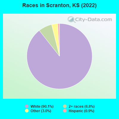
Races in Scranton detailed stats: ancestries, foreign born residents, place of birth
According to our research of Kansas and other state lists, there were 7 registered sex offenders living in Scranton, Kansas as of May 13, 2024.
The ratio of all residents to sex offenders in Scranton is 98 to 1.
Type |
2009 |
2010 |
2011 |
2012 |
2013 |
2014 |
2017 |
2021 |
2022 |
|---|---|---|---|---|---|---|---|---|---|
| Murders (per 100,000) | 0 (0.0) | 0 (0.0) | 0 (0.0) | 0 (0.0) | 0 (0.0) | 0 (0.0) | 0 (0.0) | 0 (0.0) | 0 (0.0) |
| Rapes (per 100,000) | 0 (0.0) | 0 (0.0) | 0 (0.0) | 0 (0.0) | 0 (0.0) | 0 (0.0) | 0 (0.0) | 0 (0.0) | 0 (0.0) |
| Robberies (per 100,000) | 0 (0.0) | 0 (0.0) | 0 (0.0) | 0 (0.0) | 0 (0.0) | 0 (0.0) | 0 (0.0) | 0 (0.0) | 0 (0.0) |
| Assaults (per 100,000) | 1 (147.9) | 1 (140.8) | 1 (139.9) | 0 (0.0) | 1 (142.7) | 1 (144.1) | 0 (0.0) | 0 (0.0) | 1 (153.6) |
| Burglaries (per 100,000) | 4 (591.7) | 2 (281.7) | 2 (279.7) | 2 (280.1) | 2 (285.3) | 4 (576.4) | 0 (0.0) | 3 (449.8) | 0 (0.0) |
| Thefts (per 100,000) | 2 (295.9) | 2 (281.7) | 4 (559.4) | 7 (980.4) | 12 (1,712) | 3 (432.3) | 0 (0.0) | 5 (749.6) | 5 (768.0) |
| Auto thefts (per 100,000) | 0 (0.0) | 0 (0.0) | 0 (0.0) | 0 (0.0) | 1 (142.7) | 0 (0.0) | 1 (146.4) | 0 (0.0) | 0 (0.0) |
| Arson (per 100,000) | 0 (0.0) | 0 (0.0) | 0 (0.0) | 0 (0.0) | 0 (0.0) | 0 (0.0) | 0 (0.0) | 0 (0.0) | 0 (0.0) |
| City-Data.com crime index | 82.8 | 59.2 | 69.9 | 58.8 | 128.4 | 86.5 | 11.7 | 61.5 | 61.4 |
The City-Data.com crime index weighs serious crimes and violent crimes more heavily. Higher means more crime, U.S. average is 246.1. It adjusts for the number of visitors and daily workers commuting into cities.
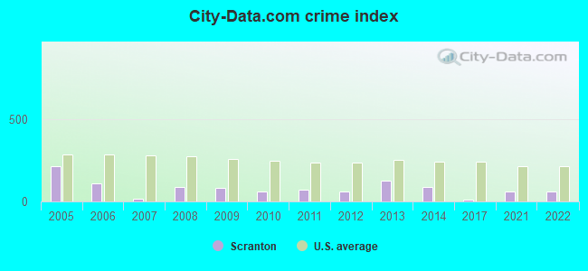
Crime rate in Scranton detailed stats: murders, rapes, robberies, assaults, burglaries, thefts, arson
Full-time law enforcement employees in 2021, including police officers: 1 (1 officers - 1 male; 0 female).
| Officers per 1,000 residents here: | 1.50 |
| Kansas average: | 2.70 |
 Recent articles from our blog. Our writers, many of them Ph.D. graduates or candidates, create easy-to-read articles on a wide variety of topics.

 | Wichita lands AAA baseball team and new stadium (26 replies) |
| Scranton Ks - children (7 replies) |
| Nice Little Town Outside of Topeka? (20 replies) |
| What kind of city is Topeka ??? Does anyone know ?? (49 replies) |
| No casino for Wichita (58 replies) |
| Wichita=80 year old woman (13 replies) |
Latest news from Scranton, KS collected exclusively by city-data.com from local newspapers, TV, and radio stations
Ancestries: European (44.7%), American (15.2%), Irish (6.5%), German (4.6%), Scotch-Irish (4.1%), English (2.8%).
Current Local Time: CST time zone
Elevation: 1123 feet
Land area: 1.07 square miles.
Population density: 601 people per square mile (low).
2 residents are foreign born
| This city: | 0.2% |
| Kansas: | 7.1% |
| Scranton city: | 1.1% ($516) |
| Kansas: | 1.2% ($999) |
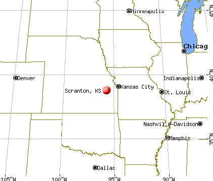
Nearest city with pop. 50,000+: Topeka, KS  (18.2 miles , pop. 122,377).
Nearest city with pop. 200,000+: Kansas City, MO (66.9 miles , pop. 441,545).
Nearest city with pop. 1,000,000+: Dallas, TX (417.8 miles , pop. 1,188,580).
Nearest cities:
), ), ), ), ), ), Latitude: 38.78 N, Longitude: 95.74 W
Area code: 785

Single-family new house construction building permits:
- 2022: 1 building, cost: $150,000
- 2021: 1 building, cost: $150,000
- 2020: 1 building, cost: $225,000
- 2016: 1 building, cost: $60,000
- 2015: 1 building, cost: $75,000
- 2013: 1 building, cost: $65,000
- 2011: 1 building, cost: $160,200
- 2010: 1 building, cost: $160,200
- 2009: 2 buildings, average cost: $125,700
- 2008: 2 buildings, average cost: $125,700
- 2007: 3 buildings, average cost: $125,700
- 2006: 3 buildings, average cost: $110,000
- 2005: 1 building, cost: $100,000
- 2004: 1 building, cost: $100,000
- 2003: 1 building, cost: $100,000
- 2002: 1 building, cost: $100,000
- 2001: 1 building, cost: $100,000
- 1999: 3 buildings, average cost: $86,700
- 1998: 2 buildings, average cost: $62,500
- 1997: 2 buildings, average cost: $62,500
| Here: | 2.0% |
| Kansas: | 2.0% |
- Health care (12.9%)
- Construction (12.0%)
- Department & other general merchandise stores (8.6%)
- Educational services (6.5%)
- Public administration (5.8%)
- Finance & insurance (4.9%)
- Food (4.0%)
- Construction (22.3%)
- Educational services (6.6%)
- Repair & maintenance (6.0%)
- Department & other general merchandise stores (5.4%)
- Food & beverage stores (4.8%)
- Truck transportation (4.8%)
- Agriculture, forestry, fishing & hunting (4.2%)
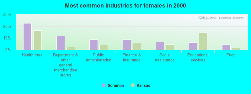
- Health care (22.6%)
- Department & other general merchandise stores (11.9%)
- Public administration (8.8%)
- Finance & insurance (8.8%)
- Social assistance (6.9%)
- Educational services (6.3%)
- Food (4.4%)
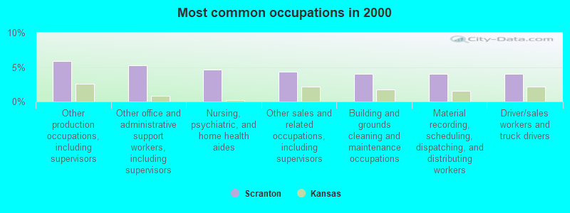
- Other production occupations, including supervisors (5.8%)
- Other office and administrative support workers, including supervisors (5.2%)
- Nursing, psychiatric, and home health aides (4.6%)
- Other sales and related occupations, including supervisors (4.3%)
- Building and grounds cleaning and maintenance occupations (4.0%)
- Material recording, scheduling, dispatching, and distributing workers (4.0%)
- Driver/sales workers and truck drivers (4.0%)
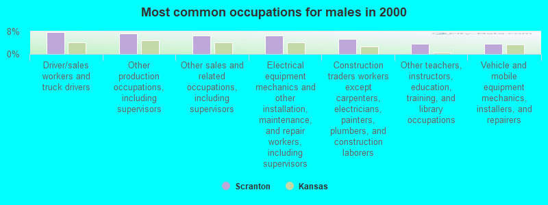
- Driver/sales workers and truck drivers (7.8%)
- Other production occupations, including supervisors (7.2%)
- Other sales and related occupations, including supervisors (6.6%)
- Electrical equipment mechanics and other installation, maintenance, and repair workers, including supervisors (6.6%)
- Construction traders workers except carpenters, electricians, painters, plumbers, and construction laborers (5.4%)
- Other teachers, instructors, education, training, and library occupations (3.6%)
- Vehicle and mobile equipment mechanics, installers, and repairers (3.6%)
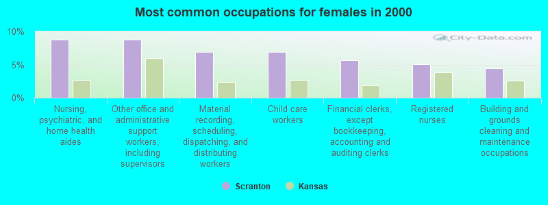
- Nursing, psychiatric, and home health aides (8.8%)
- Other office and administrative support workers, including supervisors (8.8%)
- Material recording, scheduling, dispatching, and distributing workers (6.9%)
- Child care workers (6.9%)
- Financial clerks, except bookkeeping, accounting and auditing clerks (5.7%)
- Registered nurses (5.0%)
- Building and grounds cleaning and maintenance occupations (4.4%)
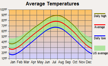
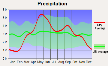
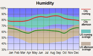
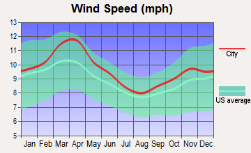
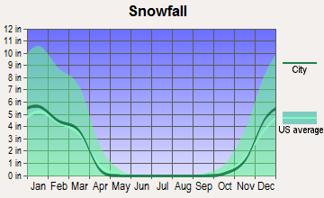
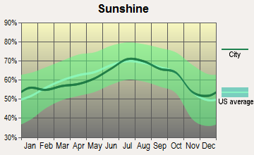
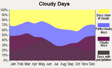
Average climate in Scranton, Kansas
Based on data reported by over 4,000 weather stations
(lower is better)
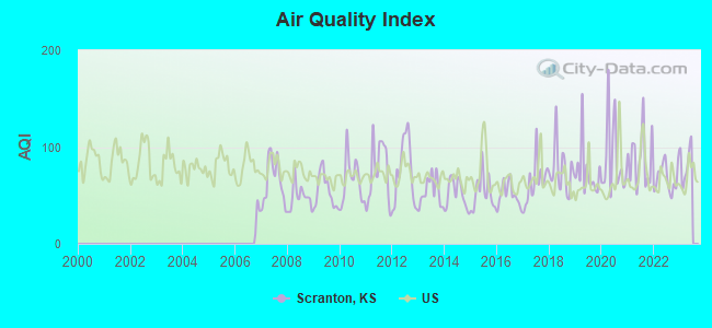
Air Quality Index (AQI) level in 2022 was 67.9. This is about average.
| City: | 67.9 |
| U.S.: | 72.6 |
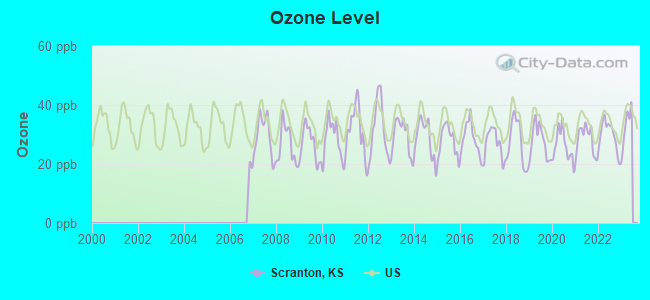
Ozone [ppb] level in 2022 was 29.6. This is about average. Closest monitor was 17.0 miles away from the city center.
| City: | 29.6 |
| U.S.: | 33.3 |
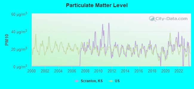
Particulate Matter (PM10) [µg/m3] level in 2022 was 24.7. This is worse than average. Closest monitor was 16.6 miles away from the city center.
| City: | 24.7 |
| U.S.: | 19.2 |
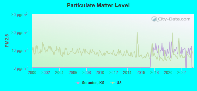
Particulate Matter (PM2.5) [µg/m3] level in 2022 was 9.39. This is about average. Closest monitor was 16.8 miles away from the city center.
| City: | 9.39 |
| U.S.: | 8.11 |
Tornado activity:
Scranton-area historical tornado activity is near Kansas state average. It is 96% greater than the overall U.S. average.
On 6/8/1966, a category F5 (max. wind speeds 261-318 mph) tornado 13.8 miles away from the Scranton city center killed 16 people and injured 450 people and caused between $50,000,000 and $500,000,000 in damages.
On 5/20/1957, a category F5 tornado 26.2 miles away from the city center killed 44 people and injured 207 people and caused between $500,000 and $5,000,000 in damages.
Earthquake activity:
Scranton-area historical earthquake activity is significantly above Kansas state average. It is 595% greater than the overall U.S. average.On 9/3/2016 at 12:02:44, a magnitude 5.8 (5.8 MW, Depth: 3.5 mi, Class: Moderate, Intensity: VI - VII) earthquake occurred 175.4 miles away from Scranton center
On 11/6/2011 at 03:53:10, a magnitude 5.7 (5.7 MW, Depth: 3.2 mi) earthquake occurred 231.6 miles away from the city center
On 11/12/2014 at 21:40:00, a magnitude 4.9 (4.9 MW, Depth: 2.5 mi, Class: Light, Intensity: IV - V) earthquake occurred 146.3 miles away from the city center
On 11/7/2016 at 01:44:24, a magnitude 5.0 (5.0 MW, Depth: 2.8 mi) earthquake occurred 201.6 miles away from the city center
On 2/13/2016 at 17:07:06, a magnitude 5.1 (5.1 MW, Depth: 5.2 mi) earthquake occurred 227.0 miles away from Scranton center
On 1/19/2020 at 19:08:42, a magnitude 4.5 (4.5 MW, Depth: 3.1 mi) earthquake occurred 131.9 miles away from Scranton center
Magnitude types: moment magnitude (MW)
Natural disasters:
The number of natural disasters in Osage County (19) is greater than the US average (15).Major Disasters (Presidential) Declared: 15
Emergencies Declared: 2
Causes of natural disasters: Floods: 12, Storms: 11, Tornadoes: 8, Winter Storms: 4, Winds: 3, Snowstorms: 2, Heavy Rain: 1, Hurricane: 1, Ice Storm: 1, Landslide: 1, Mudslide: 1, Other: 1 (Note: some incidents may be assigned to more than one category).

Hospitals and medical centers near Scranton:
- BROOKSIDE RETIREMENT COMMUNITY (Nursing Home, about 10 miles away; OVERBROOK, KS)
- OSAGE NURSING AND REHABILITATION CENTER (Nursing Home, about 11 miles away; OSAGE CITY, KS)
- PETERSON NURSING HOME (Nursing Home, about 11 miles away; OSAGE CITY, KS)
- HILLTOP HOME (Nursing Home, about 12 miles away; LYNDON, KS)
- MANOR OF TOPEKA,THE (Nursing Home, about 16 miles away; TOPEKA, KS)
- SOUTHGATE VILLAGE LIFE CARE CE (Nursing Home, about 16 miles away; TOPEKA, KS)
- MCCRITE PLAZA HEALTH CENTER (Nursing Home, about 16 miles away; TOPEKA, KS)
Colleges/universities with over 2000 students nearest to Scranton:
- Washburn University (about 18 miles; Topeka, KS; Full-time enrollment: 5,092)
- University of Kansas (about 30 miles; Lawrence, KS; FT enrollment: 22,788)
- Baker University (about 30 miles; Baldwin City, KS; FT enrollment: 2,752)
- Emporia State University (about 35 miles; Emporia, KS; FT enrollment: 4,687)
- MidAmerica Nazarene University (about 52 miles; Olathe, KS; FT enrollment: 2,158)
- Kansas State University (about 54 miles; Manhattan, KS; FT enrollment: 20,703)
- Johnson County Community College (about 56 miles; Overland Park, KS; FT enrollment: 11,976)
Public elementary/middle school in Scranton:
- SCRANTON ATTENDANCE CENTER (Students: 147, Location: 104 BURLINGAME AVE, Grades: PK-4)
Points of interest:
Notable locations in Scranton: Scranton Police Department (A), Scranton Fire Department (B), Scranton City Hall (C). Display/hide their locations on the map
Churches in Scranton include: Lighthouse Assembly of God Church (A), Scranton United Methodist Church (B), Crossroad Community Church (C), Saint Patrick Church (D). Display/hide their locations on the map
| This city: | 2.7 people |
| Kansas: | 2.5 people |
| This city: | 71.3% |
| Whole state: | 66.0% |
| This city: | 6.8% |
| Whole state: | 5.8% |
Likely homosexual households (counted as self-reported same-sex unmarried-partner households)
- Lesbian couples: 1.1% of all households
- Gay men: 0.0% of all households
Banks with branches in Scranton (2011 data):
- The Kansas State Bank Overbrook Kansas: Scranton Branch at 321 Brownie Avenue, branch established on 1988/11/21. Info updated 2006/11/03: Bank assets: $47.9 mil, Deposits: $37.9 mil, headquarters in Overbrook, KS, positive income, Agricultural Specialization, 2 total offices
For population 15 years and over in Scranton:
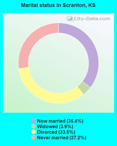
- Never married: 27.2%
- Now married: 35.4%
- Separated: 0.0%
- Widowed: 3.9%
- Divorced: 33.5%
For population 25 years and over in Scranton:
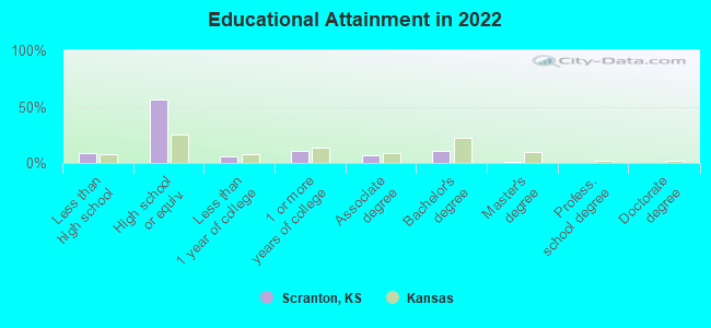
- High school or higher: 90.2%
- Bachelor's degree or higher: 11.9%
- Graduate or professional degree: 1.2%
- Unemployed: 6.1%
- Mean travel time to work (commute): 24.8 minutes
| Here: | 6.3 |
| Kansas average: | 11.5 |
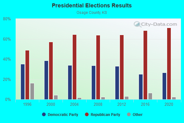
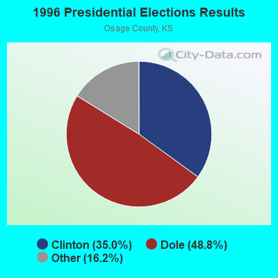
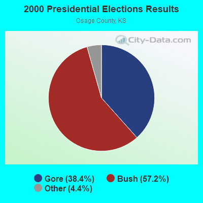
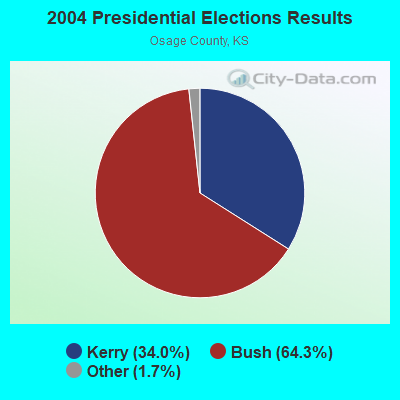
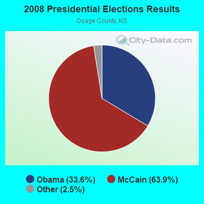

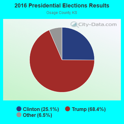
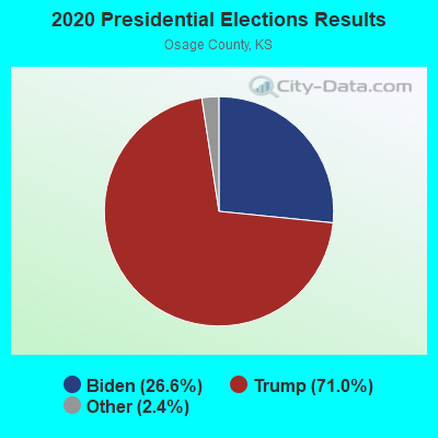
Graphs represent county-level data. Detailed 2008 Election Results
Religion statistics for Scranton, KS (based on Osage County data)
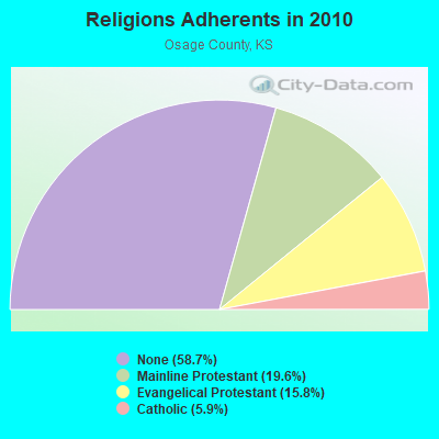
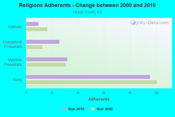
| Religion | Adherents | Congregations |
|---|---|---|
| Mainline Protestant | 3,187 | 12 |
| Evangelical Protestant | 2,573 | 19 |
| Catholic | 958 | 2 |
| Other | 7 | 1 |
| None | 9,570 | - |
Food Environment Statistics:
| Osage County: | 2.44 / 10,000 pop. |
| Kansas: | 1.96 / 10,000 pop. |
| This county: | 6.09 / 10,000 pop. |
| Kansas: | 3.84 / 10,000 pop. |
| Here: | 8.53 / 10,000 pop. |
| Kansas: | 7.33 / 10,000 pop. |
| Osage County: | 8.6% |
| Kansas: | 8.1% |
| This county: | 29.8% |
| Kansas: | 27.9% |
| Osage County: | 14.7% |
| State: | 13.4% |
Health and Nutrition:
| This city: | 54.6% |
| State: | 49.2% |
| Scranton: | 55.4% |
| State: | 46.3% |
| Scranton: | 28.5 |
| Kansas: | 28.6 |
| Scranton: | 18.1% |
| Kansas: | 21.2% |
| This city: | 6.7% |
| Kansas: | 10.5% |
| Here: | 6.9 |
| Kansas: | 6.8 |
| This city: | 36.7% |
| Kansas: | 33.5% |
| Scranton: | 62.0% |
| Kansas: | 56.0% |
| Here: | 81.1% |
| Kansas: | 78.6% |
More about Health and Nutrition of Scranton, KS Residents
| Local government employment and payroll (March 2022) | |||||
| Function | Full-time employees | Monthly full-time payroll | Average yearly full-time wage | Part-time employees | Monthly part-time payroll |
|---|---|---|---|---|---|
| Other Government Administration | 1 | $4,467 | $53,604 | 7 | $2,513 |
| Water Supply | 1 | $1,680 | $20,160 | 0 | $0 |
| Electric Power | 1 | $2,665 | $31,980 | 0 | $0 |
| Judicial and Legal | 0 | $0 | 1 | $164 | |
| Other and Unallocable | 0 | $0 | 1 | $145 | |
| Streets and Highways | 0 | $0 | 1 | $433 | |
| Fire - Other | 0 | $0 | 1 | $73 | |
| Police Protection - Officers | 0 | $0 | 5 | $5,273 | |
| Totals for Government | 3 | $8,812 | $35,248 | 16 | $8,601 |
Scranton government finances - Expenditure in 2017 (per resident):
- Current Operations - Electric Utilities: $1,004,000 ($1559.01)
Water Utilities: $150,000 ($232.92)
Police Protection: $84,000 ($130.43)
Sewerage: $62,000 ($96.27)
Solid Waste Management: $58,000 ($90.06)
Parks and Recreation: $42,000 ($65.22)
Regular Highways: $39,000 ($60.56)
Central Staff Services: $38,000 ($59.01)
Local Fire Protection: $16,000 ($24.84)
Judicial and Legal Services: $8,000 ($12.42)
- General - Interest on Debt: $86,000 ($133.54)
- Intergovernmental to Local - Other - General - Other: $28,000 ($43.48)
- Intergovernmental to State - General - Other: $251,000 ($389.75)
- Other Capital Outlay - General - Other: $12,000 ($18.63)
- Total Salaries and Wages: $217,000 ($336.96)
- Water Utilities - Interest on Debt: $84,000 ($130.43)
Scranton government finances - Revenue in 2017 (per resident):
- Charges - Sewerage: $164,000 ($254.66)
Solid Waste Management: $66,000 ($102.48)
- Local Intergovernmental - General Local Government Support: $568,000 ($881.99)
- Miscellaneous - General Revenue - Other: $25,000 ($38.82)
- Revenue - Water Utilities: $222,000 ($344.72)
- State Intergovernmental - Other: $56,000 ($86.96)
Highways: $18,000 ($27.95)
General Local Government Support: $1,000 ($1.55)
- Tax - Other License: $189,000 ($293.48)
Property: $38,000 ($59.01)
Public Utilities Sales: $6,000 ($9.32)
Scranton government finances - Debt in 2017 (per resident):
- Long Term Debt - Beginning Outstanding - Unspecified Public Purpose: $3,686,000 ($5723.60)
Outstanding Unspecified Public Purpose: $3,506,000 ($5444.10)
Retired Unspecified Public Purpose: $1,409,000 ($2187.89)
Issue, Unspecified Public Purpose: $1,229,000 ($1908.39)
Scranton government finances - Cash and Securities in 2017 (per resident):
- Bond Funds - Cash and Securities: $20,000 ($31.06)
- Other Funds - Cash and Securities: $1,527,000 ($2371.12)
Strongest AM radio stations in Scranton:
- WIBW (580 AM; 5 kW; TOPEKA, KS; Owner: MCC RADIO, LLC)
- WHB (810 AM; 50 kW; KANSAS CITY, MO; Owner: UNION BROADCASTING, INC.)
- KMAJ (1440 AM; 5 kW; TOPEKA, KS; Owner: CUMULUS LICENSING CORP.)
- KKHK (1250 AM; 25 kW; KANSAS CITY, KS)
- KCMO (710 AM; 10 kW; KANSAS CITY, MO; Owner: SUSQUEHANNA KANSAS CITY PARTNERSHIP)
- KCSP (610 AM; 5 kW; KANSAS CITY, MO; Owner: ENTERCOM KANSAS CITY LICENSE, LLC)
- KOIL (1020 AM; 50 kW; PLATTSMOUTH, NE; Owner: WAITT RADIO, INC.)
- KRMG (740 AM; 50 kW; TULSA, OK; Owner: CXR HOLDINGS, INC.)
- KFAB (1110 AM; 50 kW; OMAHA, NE; Owner: CAPSTAR TX LIMITED PARTNERSHIP)
- KCCV (760 AM; daytime; 6 kW; OVERLAND PARK, KS; Owner: BOTT BROADCASTING COMPANY)
- KTOP (1490 AM; 1 kW; TOPEKA, KS; Owner: CUMULUS LICENSING CORP.)
- KXTR (1660 AM; 10 kW; KANSAS CITY, KS; Owner: ENTERCOM KANSAS CITY LICENSE, LLC)
- KKAR (1290 AM; 50 kW; OMAHA, NE; Owner: WAITT RADIO, INC.)
Strongest FM radio stations in Scranton:
- KCHZ (95.7 FM; OTTAWA, KS; Owner: SYNCOM RADIO CORPORATION)
- KDVV (100.3 FM; TOPEKA, KS; Owner: CUMULUS LICENSING CORP.)
- WIBW-FM (94.5 FM; TOPEKA, KS; Owner: MCC RADIO, LLC)
- KMAJ-FM (107.7 FM; TOPEKA, KS; Owner: CUMULUS LICENSING CORP.)
- KTPK (106.9 FM; TOPEKA, KS; Owner: KANSAS CAPITAL BROADCASTING, INC.)
- KBUZ (90.3 FM; TOPEKA, KS; Owner: AMERICAN FAMILY ASSOCIATION, INC.)
- KLZR (105.9 FM; LAWRENCE, KS; Owner: ZIMMER RADIO OF MID-MISSOURI, INC)
- KWIC (99.3 FM; TOPEKA, KS; Owner: CUMULUS LICENSING CORP.)
- KCVT (92.5 FM; SILVER LAKE, KS; Owner: RICHARD P. BOTT, II)
- KANU (91.5 FM; LAWRENCE, KS; Owner: UNIVERSITY OF KANSAS)
- KANS (92.9 FM; OSAGE CITY, KS; Owner: C&C CONSULTING, INC.)
- KQTP (102.9 FM; ST. MARYS, KS; Owner: CUMULUS LICENSING CORP.)
- KJTY (88.1 FM; TOPEKA, KS; Owner: JOY PUBLIC BROADCASTING CORPORATION)
- K205CS (88.9 FM; TOPEKA, KS; Owner: CALVARY CHAPEL OF TWIN FALLS, INC.)
TV broadcast stations around Scranton:
- KTKA-TV (Channel 49; TOPEKA, KS; Owner: NORTHEAST KANSAS BROADCAST SERVICE, INC.)
- KTWU (Channel 11; TOPEKA, KS; Owner: WASHBURN UNIVERSITY OF TOPEKA)
- KSNT (Channel 27; TOPEKA, KS; Owner: EMMIS TELEVISION LICENSE CORPORATION OF TOPEKA)
- WIBW-TV (Channel 13; TOPEKA, KS; Owner: GRAY MIDAMERICA TV LICENSEE CORP.)
- KTMJ-CA (Channel 43; TOPEKA, KS; Owner: MONTGOMERY COMMUNICATIONS, INC.)
- K21AP (Channel 55; TOPEKA, KS; Owner: TRINITY BROADCASTING NETWORK)
- KETM-CA (Channel 17; EMPORIA, KS; Owner: MONTGOMERY COMMUNICATIONS, INC.)
Scranton fatal accident list:
- National Bridge Inventory (NBI) Statistics
- 10Number of bridges
- 89ft / 26.7mTotal length
- 9,248Total average daily traffic
- 1,242Total average daily truck traffic
- 12,257Total future (year 2039) average daily traffic
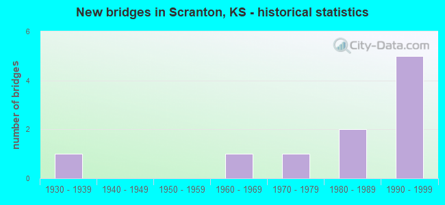
- New bridges - historical statistics
- 11930-1939
- 11960-1969
- 11970-1979
- 21980-1989
- 51990-1999
FCC Registered Cell Phone Towers:
1 (See the full list of FCC Registered Cell Phone Towers in Scranton)FCC Registered Antenna Towers:
28 (See the full list of FCC Registered Antenna Towers)FCC Registered Broadcast Land Mobile Towers:
2- Hwy 56 And Mercer (Lat: 38.779444 Lon: -95.738306), Call Sign: KNDU915,
Assigned Frequencies: 456.350 MHz, Grant Date: 07/20/2022, Expiration Date: 10/22/2031, Registrant: S&a Telephone, 413 Main Street, Allen, KS 66833, Phone: (620) 528-3223, Fax: (620) 528-3226, Email:
- Elevated Tank Braken St & Brownie St (Lat: 38.780556 Lon: -95.738306), Call Sign: KNER371,
Assigned Frequencies: 173.312 MHz, Grant Date: 12/30/1997, Expiration Date: 01/13/2003, Cancellation Date: 12/10/2002, Registrant: City Of Scranton, City Hall, Scranton, KS 66537
FCC Registered Microwave Towers:
9 (See the full list of FCC Registered Microwave Towers in this town)FCC Registered Amateur Radio Licenses:
12 (See the full list of FCC Registered Amateur Radio Licenses in Scranton)FAA Registered Aircraft:
2- Aircraft: PIPER J3F-65 (Category: Land, Seats: 2, Weight: Up to 12,499 Pounds, Speed: 67 mph), Engine: CONT MOTOR A&C65 SERIES (65 HP) (Reciprocating)
N-Number: 32737, N32737, N-32737, Serial Number: 5569, Year manufactured: 1940, Airworthiness Date: 11/28/1973, Certificate Issue Date: 10/27/2011
Registrant (Individual): Ronald D Baker, 684 E 189th St, Scranton, KS 66537 - Aircraft: STINSON 108-3 (Category: Land, Seats: 4, Weight: Up to 12,499 Pounds, Speed: 94 mph), Engine: FRANKLIN 6A4165 SERIES (165 HP) (Reciprocating)
N-Number: 6668M, N6668M, N-6668M, Serial Number: 108-4668, Year manufactured: 1948, Airworthiness Date: 03/20/1957, Certificate Issue Date: 07/28/2015
Registrant (Individual): Ronald D Baker, 684 E 189th St, Scranton, KS 66537
2003 - 2018 National Fire Incident Reporting System (NFIRS) incidents
- Fire incident types reported to NFIRS in Scranton, KS
- 8662.8%Outside Fires
- 4129.9%Structure Fires
- 85.8%Mobile Property/Vehicle Fires
- 21.5%Other
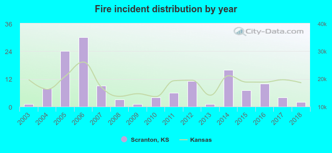 Based on the data from the years 2003 - 2018 the average number of fires per year is 9. The highest number of fire incidents - 30 took place in 2006, and the least - 1 in 2003. The data has an increasing trend.
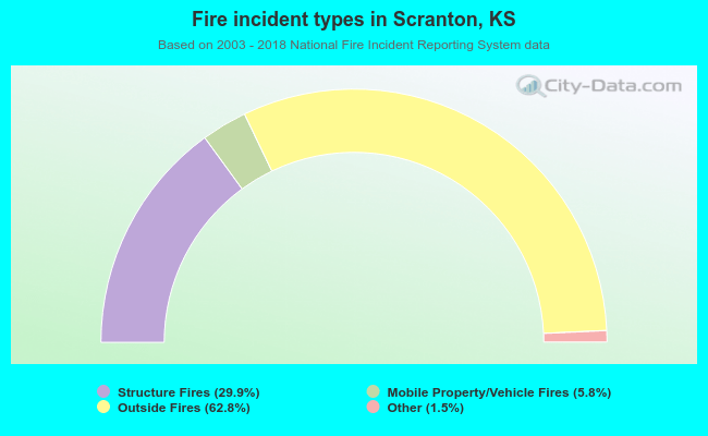 When looking into fire subcategories, the most incidents belonged to: Outside Fires (62.8%), and Structure Fires (29.9%).
| Most common first names in Scranton, KS among deceased individuals | ||
| Name | Count | Lived (average) |
|---|---|---|
| John | 13 | 79.0 years |
| William | 11 | 80.0 years |
| Robert | 9 | 74.2 years |
| Carl | 7 | 79.0 years |
| Charles | 7 | 69.8 years |
| Walter | 6 | 81.5 years |
| James | 5 | 81.2 years |
| Earl | 5 | 73.4 years |
| Florence | 5 | 88.0 years |
| Joseph | 5 | 86.4 years |
| Most common last names in Scranton, KS among deceased individuals | ||
| Last name | Count | Lived (average) |
|---|---|---|
| Rowe | 12 | 85.1 years |
| Smith | 7 | 73.1 years |
| Bodine | 6 | 73.0 years |
| Johnson | 6 | 78.3 years |
| Wilson | 6 | 76.0 years |
| Hutchison | 5 | 73.6 years |
| Isaacs | 5 | 88.4 years |
| Shepard | 5 | 79.6 years |
| Ullery | 5 | 87.4 years |
| Anderson | 4 | 85.2 years |
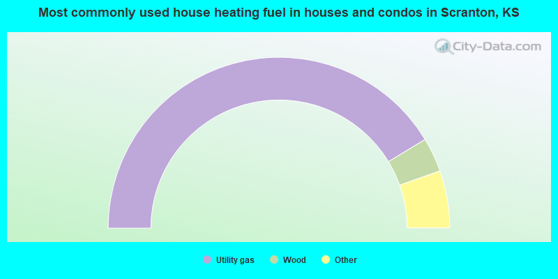
- 82.9%Utility gas
- 6.5%Wood
- 4.0%Bottled, tank, or LP gas
- 2.9%Electricity
- 1.8%Other fuel
- 1.8%No fuel used
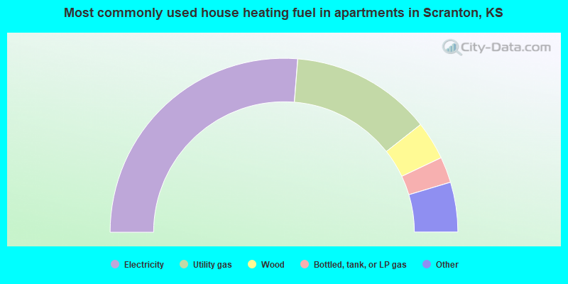
- 57.9%Electricity
- 28.9%Utility gas
- 7.9%Wood
- 5.3%Bottled, tank, or LP gas
Scranton compared to Kansas state average:
- Median house value significantly below state average.
- Unemployed percentage below state average.
- Black race population percentage significantly below state average.
- Hispanic race population percentage significantly below state average.
- Foreign-born population percentage significantly below state average.
- Renting percentage below state average.
- Length of stay since moving in significantly above state average.
- Number of college students below state average.
- Percentage of population with a bachelor's degree or higher below state average.
Scranton on our top lists:
- #59 on the list of "Top 101 cities with the most cars per house, population 500+"
- #36 on the list of "Top 101 counties with the lowest ground withdrawal of fresh water for public supply"