Shiloh, Kentucky
Submit your own pictures of this place and show them to the world
- OSM Map
- General Map
- Google Map
- MSN Map

| Males: 2,189 | |
| Females: 2,175 |
| Median resident age: | 38.6 years |
| Kentucky median age: | 35.9 years |
Zip code: 42071
| Shiloh: | $47,215 |
| KY: | $59,341 |
Estimated per capita income in 2022: $27,113 (it was $15,907 in 2000)
Shiloh CCD income, earnings, and wages data
Estimated median house or condo value in 2022: $149,013 (it was $61,500 in 2000)
| Shiloh: | $149,013 |
| KY: | $196,300 |
Detailed information about poverty and poor residents in Shiloh, KY


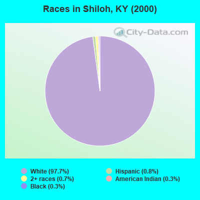
- 4,03197.7%White alone
- 340.8%Hispanic
- 300.7%Two or more races
- 120.3%Black alone
- 130.3%American Indian alone
- 40.10%Asian alone
Races in Shiloh detailed stats: ancestries, foreign born residents, place of birth
 Recent articles from our blog. Our writers, many of them Ph.D. graduates or candidates, create easy-to-read articles on a wide variety of topics.
Current Local Time: CST time zone
Elevation: 504 feet
Land area: 89.3 square miles.
Population density: 49 people per square mile (very low).

| Shiloh CCD: | 0.6% ($378) |
| Kentucky: | 0.8% ($610) |
Nearest city with pop. 50,000+: Clarksville, TN  (45.9 miles , pop. 103,455).
Nearest city with pop. 200,000+: Metropolitan Government, TN (86.1 miles , pop. 569,891).
Nearest city with pop. 1,000,000+: Chicago, IL (358.1 miles , pop. 2,896,016).
Nearest cities:
), ), ), ), ), Latitude: 36.68 N, Longitude: 88.17 W
Area code commonly used in this area: 270

| Here: | 4.2% |
| Kentucky: | 3.8% |
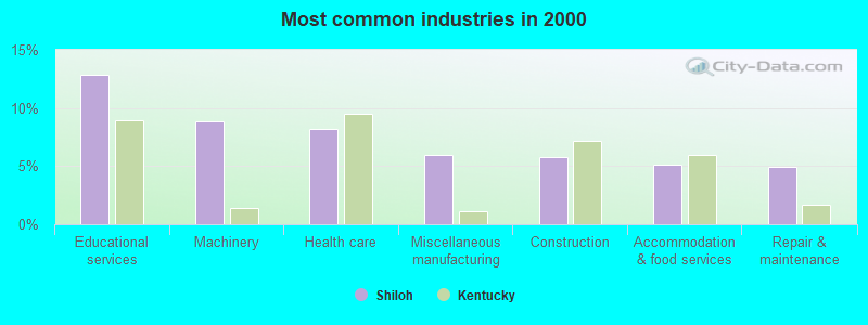
- Educational services (12.9%)
- Machinery (8.9%)
- Health care (8.2%)
- Miscellaneous manufacturing (6.0%)
- Construction (5.7%)
- Accommodation & food services (5.1%)
- Repair & maintenance (4.9%)
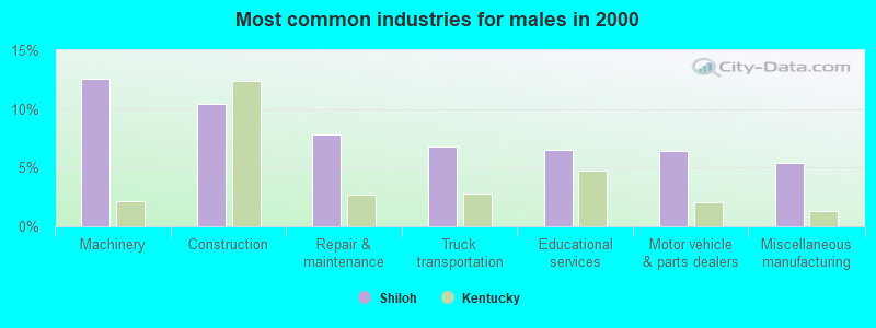
- Machinery (12.6%)
- Construction (10.4%)
- Repair & maintenance (7.8%)
- Truck transportation (6.8%)
- Educational services (6.5%)
- Motor vehicle & parts dealers (6.4%)
- Miscellaneous manufacturing (5.4%)
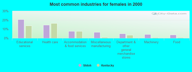
- Educational services (20.6%)
- Health care (14.6%)
- Accommodation & food services (7.8%)
- Miscellaneous manufacturing (6.7%)
- Department & other general merchandise stores (5.2%)
- Machinery (4.3%)
- Food (3.7%)
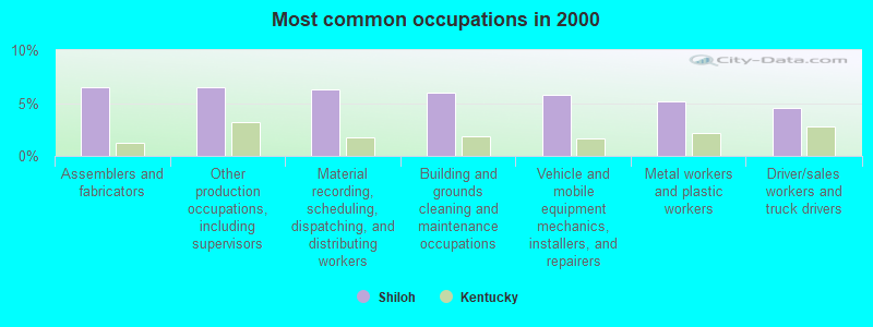
- Assemblers and fabricators (6.5%)
- Other production occupations, including supervisors (6.5%)
- Material recording, scheduling, dispatching, and distributing workers (6.3%)
- Building and grounds cleaning and maintenance occupations (5.9%)
- Vehicle and mobile equipment mechanics, installers, and repairers (5.7%)
- Metal workers and plastic workers (5.2%)
- Driver/sales workers and truck drivers (4.5%)
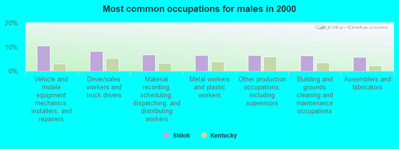
- Vehicle and mobile equipment mechanics, installers, and repairers (10.4%)
- Driver/sales workers and truck drivers (8.2%)
- Material recording, scheduling, dispatching, and distributing workers (6.8%)
- Metal workers and plastic workers (6.5%)
- Other production occupations, including supervisors (6.5%)
- Building and grounds cleaning and maintenance occupations (6.4%)
- Assemblers and fabricators (5.8%)

- Secretaries and administrative assistants (8.6%)
- Assemblers and fabricators (7.3%)
- Other production occupations, including supervisors (6.5%)
- Preschool, kindergarten, elementary, and middle school teachers (5.8%)
- Material recording, scheduling, dispatching, and distributing workers (5.6%)
- Building and grounds cleaning and maintenance occupations (5.4%)
- Retail sales workers, except cashiers (5.2%)
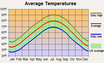
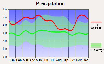
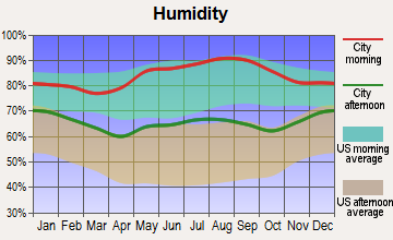
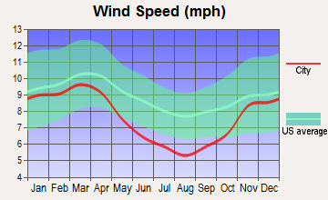
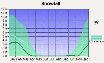
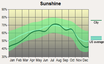
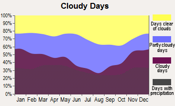
Average climate in Shiloh, Kentucky
Based on data reported by over 4,000 weather stations
(lower is better)
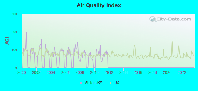
Air Quality Index (AQI) level in 2011 was 70.5. This is about average.
| City: | 70.5 |
| U.S.: | 72.6 |
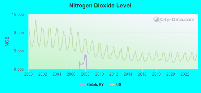
Nitrogen Dioxide (NO2) [ppb] level in 2007 was 1.91. This is significantly better than average. Closest monitor was 4.9 miles away from the city center.
| City: | 1.91 |
| U.S.: | 5.11 |
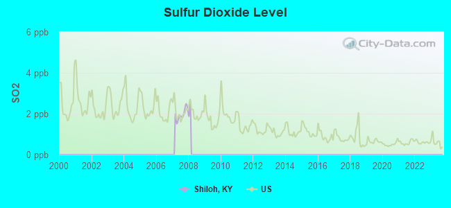
Sulfur Dioxide (SO2) [ppb] level in 2007 was 1.97. This is worse than average. Closest monitor was 4.9 miles away from the city center.
| City: | 1.97 |
| U.S.: | 1.51 |
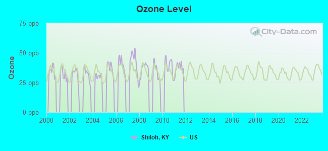
Ozone [ppb] level in 2011 was 37.2. This is about average. Closest monitor was 4.9 miles away from the city center.
| City: | 37.2 |
| U.S.: | 33.3 |
Tornado activity:
Shiloh-area historical tornado activity is slightly above Kentucky state average. It is 66% greater than the overall U.S. average.
On 4/3/1968, a category F4 (max. wind speeds 207-260 mph) tornado 7.9 miles away from the Shiloh place center killed 2 people and injured 30 people and caused between $500,000 and $5,000,000 in damages.
On 3/4/1964, a category F4 tornado 14.1 miles away from the place center killed 3 people and injured 24 people and caused between $50,000 and $500,000 in damages.
Earthquake activity:
Shiloh-area historical earthquake activity is significantly above Kentucky state average. It is 288% greater than the overall U.S. average.On 4/18/2008 at 09:36:59, a magnitude 5.4 (5.1 MB, 4.8 MS, 5.4 MW, 5.2 MW, Class: Moderate, Intensity: VI - VII) earthquake occurred 123.7 miles away from Shiloh center
On 4/18/2008 at 09:36:59, a magnitude 5.2 (5.2 MW, Depth: 8.9 mi) earthquake occurred 123.7 miles away from the city center
On 9/26/1990 at 13:18:51, a magnitude 5.0 (4.7 MB, 4.8 LG, 5.0 LG, Depth: 7.7 mi) earthquake occurred 82.6 miles away from Shiloh center
On 5/4/1991 at 01:18:54, a magnitude 5.0 (4.4 MB, 4.6 LG, 5.0 LG, Depth: 3.1 mi) earthquake occurred 92.0 miles away from the city center
On 6/18/2002 at 17:37:15, a magnitude 5.0 (4.3 MB, 4.6 MW, 5.0 LG) earthquake occurred 93.1 miles away from Shiloh center
On 6/10/1987 at 23:48:54, a magnitude 5.1 (4.9 MB, 4.4 MS, 4.6 MS, 5.1 LG) earthquake occurred 149.1 miles away from the city center
Magnitude types: regional Lg-wave magnitude (LG), body-wave magnitude (MB), surface-wave magnitude (MS), moment magnitude (MW)
Natural disasters:
The number of natural disasters in Calloway County (11) is smaller than the US average (15).Major Disasters (Presidential) Declared: 8
Emergencies Declared: 2
Causes of natural disasters: Floods: 6, Storms: 5, Winter Storms: 3, Tornadoes: 2, Blizzard: 1, Hurricane: 1, Landslide: 1, Mudslide: 1, Snowstorm: 1, Tropical Depression: 1, Wind: 1, Other: 1 (Note: some incidents may be assigned to more than one category).
Hospitals and medical centers near Shiloh:
- HOME HEALTH PLUS, INC (Home Health Center, about 9 miles away; MURRAY, KY)
- FMC - DIALYSIS OF MURRAY (Dialysis Facility, about 9 miles away; MURRAY, KY)
- MURRAY-CALLOWAY COUNTY HOSPITAL Acute Care Hospitals (about 9 miles away; MURRAY, KY)
- SPRING CREEK HEALTH CARE (Nursing Home, about 11 miles away; MURRAY, KY)
- WEST VIEW NURSING HOME (Nursing Home, about 11 miles away; MURRAY, KY)
- MARSHALL COUNTY HOSPITAL HHA (Home Health Center, about 16 miles away; BENTON, KY)
- MARSHALL CO HOSP SNF (Nursing Home, about 16 miles away; BENTON, KY)
Colleges/universities with over 2000 students nearest to Shiloh:
- Murray State University (about 10 miles; Murray, KY; Full-time enrollment: 8,930)
- West Kentucky Community and Technical College (about 38 miles; Paducah, KY; FT enrollment: 4,107)
- Hopkinsville Community College (about 41 miles; Hopkinsville, KY; FT enrollment: 2,269)
- Bethel University (about 42 miles; McKenzie, TN; FT enrollment: 5,878)
- The University of Tennessee-Martin (about 46 miles; Martin, TN; FT enrollment: 7,013)
- Austin Peay State University (about 47 miles; Clarksville, TN; FT enrollment: 8,621)
- Madisonville Community College (about 60 miles; Madisonville, KY; FT enrollment: 2,082)
Points of interest:
Notable locations in Shiloh: Center Ridge Cabin Area (A), Pottertown Fire Station (B), Faxon Fire Station (C). Display/hide their locations on the map
Churches in Shiloh include: Friendship Church (A), Ledbetter Church (B), Liberty Church (C), Palestine Church (D), Pleasant Valley Church (E), Poplar Springs Church (F), Sugar Creek Church (G), Temple Hill Church (H), Russell Chapel (I). Display/hide their locations on the map
Cemeteries: Bonner Cemetery (1), Byars Cemetery (2), Lone Oak Cemetery (3), Harris Cemetery (4), Terry Cemetery (5), Haynes Cemetery (6), Curd Cemetery (7). Display/hide their locations on the map
Streams, rivers, and creeks: Anderson Creek (A), Brush Creek (B), Crisp Branch (C), Sugar Creek (D), Wildcat Creek (E), Burr Branch (F), Snipe Creek (G), Little Jonathan Creek (H), Lick Branch (I). Display/hide their locations on the map
Park in Shiloh: Kenlake State Park (1). Display/hide its location on the map
| This place: | 2.4 people |
| Kentucky: | 2.5 people |
| This place: | 69.4% |
| Whole state: | 66.9% |
| This place: | 5.7% |
| Whole state: | 6.4% |
Likely homosexual households (counted as self-reported same-sex unmarried-partner households)
- Lesbian couples: 0.2% of all households
- Gay men: 0.3% of all households
| This place: | 17.4% |
| Whole state: | 15.8% |
| This place: | 6.7% |
| Whole state: | 6.6% |
For population 15 years and over in Shiloh:
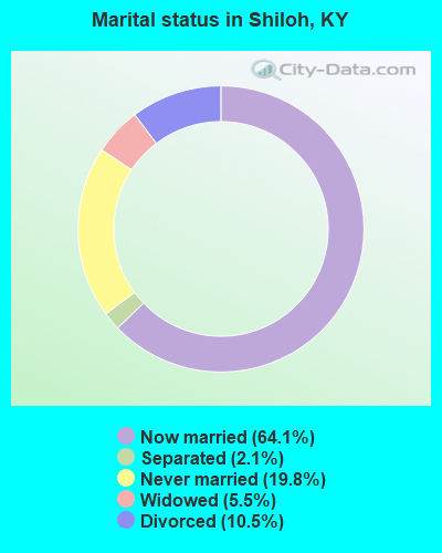
- Never married: 19.8%
- Now married: 64.1%
- Separated: 2.1%
- Widowed: 5.5%
- Divorced: 10.5%
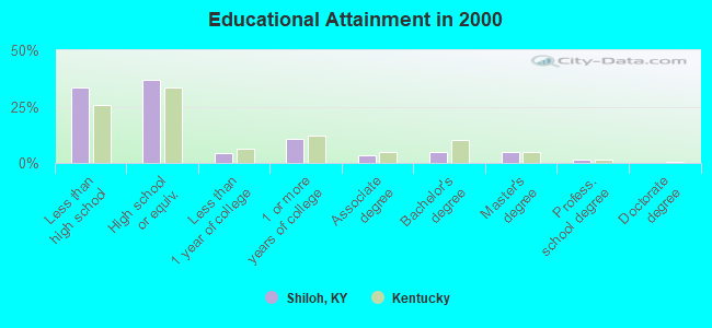
For population 25 years and over in Shiloh:
- High school or higher: 66.5%
- Bachelor's degree or higher: 11.0%
- Graduate or professional degree: 6.3%
- Unemployed: 6.7%
- Mean travel time to work (commute): 22.6 minutes
| Here: | 13.1 |
| Kentucky average: | 13.8 |
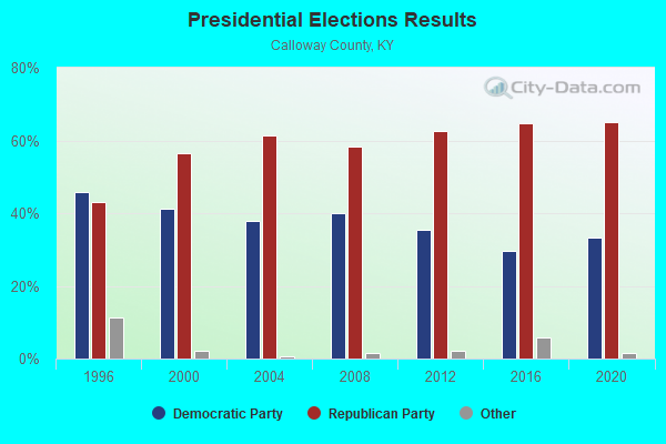
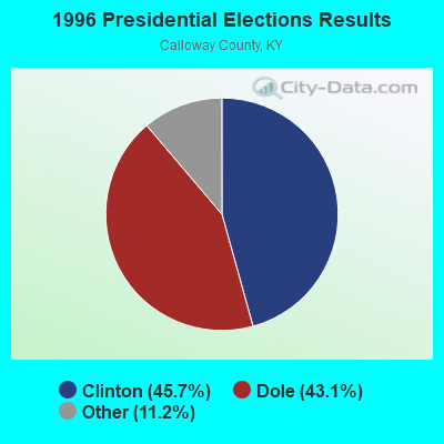
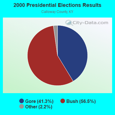
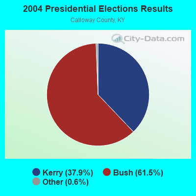
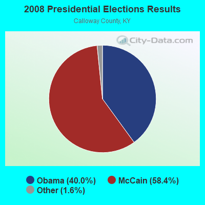
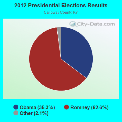
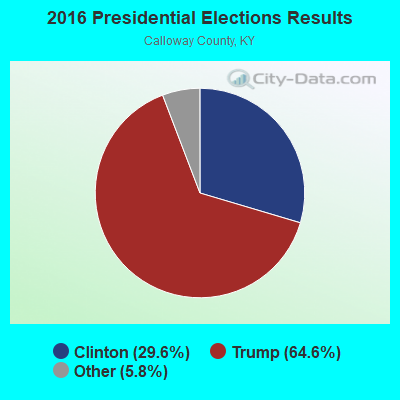
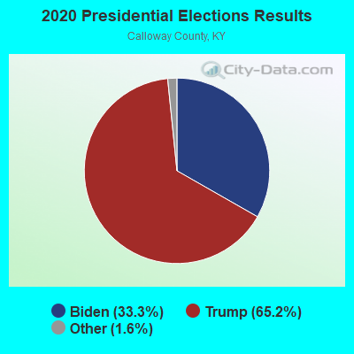
Graphs represent county-level data. Detailed 2008 Election Results
Religion statistics for Shiloh, KY (based on Calloway County data)
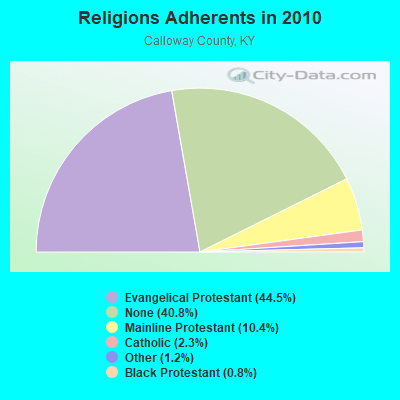
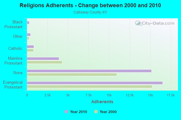
| Religion | Adherents | Congregations |
|---|---|---|
| Evangelical Protestant | 16,535 | 62 |
| Mainline Protestant | 3,880 | 20 |
| Catholic | 862 | 1 |
| Other | 451 | 3 |
| Black Protestant | 290 | 2 |
| None | 15,173 | - |
Food Environment Statistics:
| Here: | 1.11 / 10,000 pop. |
| State: | 2.19 / 10,000 pop. |
| Calloway County: | 0.28 / 10,000 pop. |
| State: | 0.25 / 10,000 pop. |
| Calloway County: | 3.05 / 10,000 pop. |
| State: | 4.36 / 10,000 pop. |
| Calloway County: | 7.48 / 10,000 pop. |
| State: | 5.74 / 10,000 pop. |
| Calloway County: | 9.5% |
| State: | 11.0% |
| This county: | 27.7% |
| Kentucky: | 30.0% |
| Here: | 12.4% |
| Kentucky: | 15.9% |
Strongest AM radio stations in Shiloh:
- WRKY (1130 AM; 2 kW; MURRAY, KY; Owner: FOREVER COMMUNICATIONS INC)
- WCBL (1290 AM; 5 kW; BENTON, KY; Owner: JIM W. FREELAND)
- WNBS (1340 AM; 1 kW; MURRAY, KY; Owner: FOREVER COMMUNICATIONS INC)
- WSM (650 AM; 50 kW; NASHVILLE, TN; Owner: GAYLORD ENTERTAINMENT COMPANY)
- WMUF (1000 AM; daytime; 5 kW; PARIS, TN; Owner: BENTON-WEATHERFORD B/CTING OF TN,INC)
- WKDA (1200 AM; 50 kW; NASHVILLE, TN; Owner: RADIO NASHVILLE, INC.)
- WNQM (1300 AM; 50 kW; NASHVILLE, TN; Owner: WNQM. INC.)
- WAMB (1160 AM; 50 kW; DONELSON, TN; Owner: GREAT SOUTHERN BROADCASTING COMPANY, INC.)
- WPAD (1560 AM; 10 kW; PADUCAH, KY; Owner: BRISTOL BROADCASTING COMPANY, INC.)
- WLAC (1510 AM; 50 kW; NASHVILLE, TN; Owner: CAPSTAR TX LIMITED PARTNERSHIP)
- WCRV (640 AM; 50 kW; COLLIERVILLE, TN; Owner: BOTT BROADCASTING COMPANY/TENNESSEE)
- WGSF (1030 AM; 50 kW; MEMPHIS, TN; Owner: FLINN BROADCASTING CORPORATION)
- WDIA (1070 AM; 50 kW; MEMPHIS, TN; Owner: CLEAR CHANNEL BROADCASTING LICENSES, INC.)
Strongest FM radio stations in Shiloh:
- WKMS-FM (91.3 FM; MURRAY, KY; Owner: MURRAY STATE UNIVERSITY)
- WFGE (103.7 FM; MURRAY, KY; Owner: FOREVER COMMUNICATIONS INC)
- WVHM (90.5 FM; BENTON, KY; Owner: HEARTLAND MINISTRIES, INC.)
- WAAJ (89.7 FM; BENTON, KY; Owner: HEARTLAND MINISTRIES, INC.)
- WVVR (100.3 FM; HOPKINSVILLE, KY; Owner: SAGA COMMUNICATIONS OF TUCKESSEE, LLC)
- WCVQ (107.9 FM; FORT CAMPBELL, KY; Owner: SAGA COMMUNICATIONS OF TUCKESSEE, LLC)
- WTRT (88.1 FM; BENTON, KY; Owner: HEARTLAND MINISTRIES, INC.)
- WKYQ (93.3 FM; PADUCAH, KY; Owner: BRISTOL BROADCASTING COMPANY, INC.)
- WCBL-FM (99.1 FM; BENTON, KY; Owner: JIM W. FREELAND)
- WTPR-FM (101.5 FM; MCKINNON, TN; Owner: WENK BROADCAST GROUP)
- WDDJ (96.9 FM; PADUCAH, KY; Owner: BRISTOL BROADCASTING COMPANY, INC.)
- WCCK (95.7 FM; CALVERT CITY, KY; Owner: JIM W. FREELAND DBA FREELAND BROADCASTING)
- WKDZ-FM (106.5 FM; CADIZ, KY; Owner: HAM BROADCASTING COMPANY, INC.)
- WLLE (94.7 FM; MAYFIELD, KY; Owner: FOREVER COMMUNICATIONS KY, LLC)
TV broadcast stations around Shiloh:
- WQTV-LP (Channel 24; MURRAY, KY; Owner: RAYCOM AMERICA, INC.)
- WKMU (Channel 21; MURRAY, KY; Owner: KENTUCKY AUTHORITY FOR EDUCATIONAL TV)
- WDKA (Channel 49; PADUCAH, KY; Owner: WDKA ACQUISITION CORPORATION)
- WCKV-LP (Channel 49; CLARKSVILLE, ETC., TN; Owner: TN MEDIA GROUP, INC.)
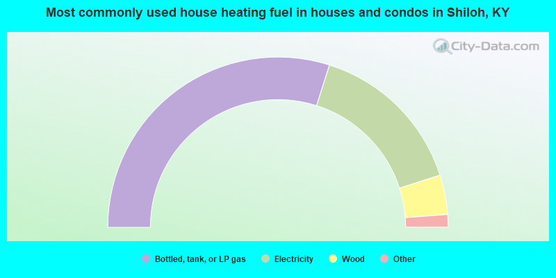
- 59.8%Bottled, tank, or LP gas
- 30.3%Electricity
- 7.5%Wood
- 1.4%Utility gas
- 1.0%Fuel oil, kerosene, etc.
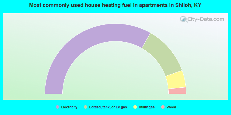
- 66.5%Electricity
- 22.6%Bottled, tank, or LP gas
- 7.8%Utility gas
- 3.1%Wood
Shiloh compared to Kentucky state average:
- Unemployed percentage below state average.
- Black race population percentage significantly below state average.
- Hispanic race population percentage significantly below state average.
- Foreign-born population percentage significantly below state average.
- Renting percentage below state average.
- Length of stay since moving in significantly above state average.
- Number of rooms per house significantly below state average.
- House age significantly below state average.
- Percentage of population with a bachelor's degree or higher below state average.