Shorterville, Alabama
Submit your own pictures of this place and show them to the world
- OSM Map
- General Map
- Google Map
- MSN Map

| Males: 1,486 | |
| Females: 1,531 |
| Median resident age: | 42.3 years |
| Alabama median age: | 35.8 years |
Zip code: 36310
| Shorterville: | $59,443 |
| AL: | $59,674 |
Estimated per capita income in 2022: $32,217 (it was $16,474 in 2000)
Shorterville CCD income, earnings, and wages data
Estimated median house or condo value in 2022: $143,146 (it was $55,900 in 2000)
| Shorterville: | $143,146 |
| AL: | $200,900 |
Mean prices in 2022: all housing units: $188,931; detached houses: $221,578; townhouses or other attached units: $81,519; mobile homes: $73,081
Detailed information about poverty and poor residents in Shorterville, AL


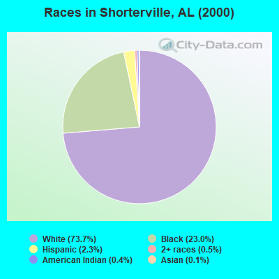
- 2,18273.7%White alone
- 68023.0%Black alone
- 672.3%Hispanic
- 150.5%Two or more races
- 130.4%American Indian alone
- 40.1%Asian alone
- 10.03%Native Hawaiian and Other
Pacific Islander alone
According to our research of Alabama and other state lists, there was 1 registered sex offender living in Shorterville, Alabama as of May 22, 2024.
The ratio of all residents to sex offenders in Shorterville is 3,017 to 1.
The ratio of registered sex offenders to all residents in this city is much lower than the state average.
 Recent articles from our blog. Our writers, many of them Ph.D. graduates or candidates, create easy-to-read articles on a wide variety of topics.
Current Local Time: CST time zone
Elevation: 419 feet
Land area: 130.5 square miles.
Population density: 23 people per square mile (very low).

| Shorterville CCD: | 0.4% ($199) |
| Alabama: | 0.4% ($289) |
Nearest city with pop. 50,000+: Dothan, AL  (32.1 miles , pop. 57,737).
Nearest city with pop. 200,000+: Montgomery, AL (84.1 miles , pop. 201,568).
Nearest city with pop. 1,000,000+: Houston, TX (622.8 miles , pop. 1,953,631).
Nearest cities:
), ), ), )Latitude: 31.63 N, Longitude: 85.13 W


| Here: | 2.9% |
| Alabama: | 2.6% |
- Textile mills & textile products (12.7%)
- Accommodation & food services (7.6%)
- Construction (6.6%)
- Health care (6.6%)
- Educational services (5.6%)
- Public administration (4.9%)
- Truck transportation (4.8%)
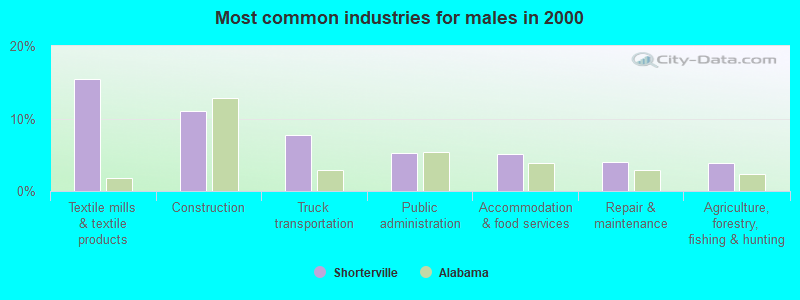
- Textile mills & textile products (15.4%)
- Construction (11.0%)
- Truck transportation (7.8%)
- Public administration (5.2%)
- Accommodation & food services (5.1%)
- Repair & maintenance (4.0%)
- Agriculture, forestry, fishing & hunting (3.8%)
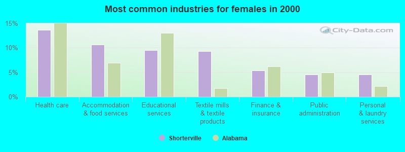
- Health care (13.6%)
- Accommodation & food services (10.7%)
- Educational services (9.5%)
- Textile mills & textile products (9.3%)
- Finance & insurance (5.3%)
- Public administration (4.5%)
- Personal & laundry services (4.5%)
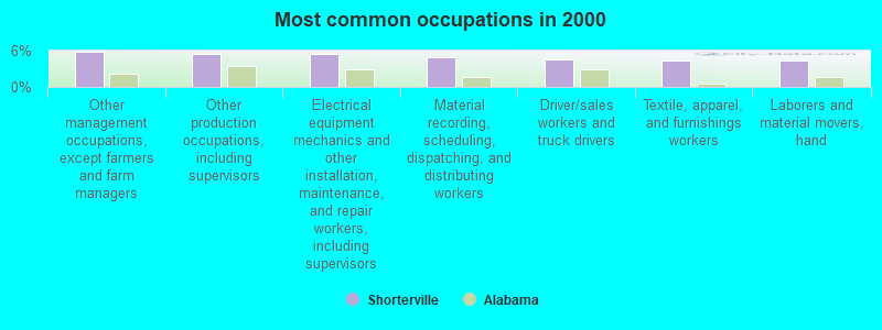
- Other management occupations, except farmers and farm managers (5.8%)
- Other production occupations, including supervisors (5.4%)
- Electrical equipment mechanics and other installation, maintenance, and repair workers, including supervisors (5.4%)
- Material recording, scheduling, dispatching, and distributing workers (4.9%)
- Driver/sales workers and truck drivers (4.5%)
- Textile, apparel, and furnishings workers (4.4%)
- Laborers and material movers, hand (4.4%)
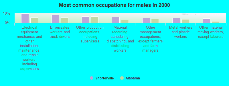
- Electrical equipment mechanics and other installation, maintenance, and repair workers, including supervisors (9.7%)
- Driver/sales workers and truck drivers (8.1%)
- Other production occupations, including supervisors (6.5%)
- Material recording, scheduling, dispatching, and distributing workers (6.0%)
- Other management occupations, except farmers and farm managers (4.9%)
- Metal workers and plastic workers (4.8%)
- Other material moving workers, except laborers (4.6%)
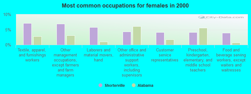
- Textile, apparel, and furnishings workers (7.1%)
- Other management occupations, except farmers and farm managers (6.9%)
- Laborers and material movers, hand (5.7%)
- Other office and administrative support workers, including supervisors (4.3%)
- Customer service representatives (4.2%)
- Preschool, kindergarten, elementary, and middle school teachers (4.2%)
- Food and beverage serving workers, except waiters and waitresses (4.0%)
Average climate in Shorterville, Alabama
Based on data reported by over 4,000 weather stations


Tornado activity:
Shorterville-area historical tornado activity is slightly below Alabama state average. It is 50% greater than the overall U.S. average.
On 12/29/1973, a category F3 (max. wind speeds 158-206 mph) tornado 9.2 miles away from the Shorterville place center injured 2 people and caused between $500,000 and $5,000,000 in damages.
On 1/13/1972, a category F3 tornado 15.7 miles away from the place center injured 2 people and caused between $50,000 and $500,000 in damages.
Earthquake activity:
Shorterville-area historical earthquake activity is significantly above Alabama state average. It is 12% greater than the overall U.S. average.On 10/24/1997 at 08:35:17, a magnitude 4.9 (4.8 MB, 4.2 MS, 4.9 LG, Depth: 6.2 mi, Class: Light, Intensity: IV - V) earthquake occurred 131.0 miles away from the city center
On 1/18/1999 at 07:00:53, a magnitude 4.8 (4.8 MB, 4.0 LG, Depth: 0.6 mi) earthquake occurred 174.3 miles away from Shorterville center
On 4/29/2003 at 08:59:39, a magnitude 4.9 (4.4 MB, 4.6 MW, 4.9 LG) earthquake occurred 200.2 miles away from the city center
On 8/2/1974 at 08:52:09, a magnitude 4.9 (4.3 MB, 4.9 LG) earthquake occurred 218.6 miles away from the city center
On 4/29/2003 at 08:59:39, a magnitude 4.6 (4.6 MW, Depth: 12.3 mi) earthquake occurred 200.2 miles away from Shorterville center
On 6/24/1975 at 11:11:36, a magnitude 4.5 (4.5 MB) earthquake occurred 213.8 miles away from Shorterville center
Magnitude types: regional Lg-wave magnitude (LG), body-wave magnitude (MB), surface-wave magnitude (MS), moment magnitude (MW)
Natural disasters:
The number of natural disasters in Henry County (21) is greater than the US average (15).Major Disasters (Presidential) Declared: 14
Emergencies Declared: 5
Causes of natural disasters: Storms: 11, Tornadoes: 9, Floods: 7, Hurricanes: 6, Winds: 4, Drought: 1, Snowfall: 1, Tropical Storm: 1, Winter Storm: 1, Other: 1 (Note: some incidents may be assigned to more than one category).
Colleges/universities with over 2000 students nearest to Shorterville:
- George C Wallace State Community College-Dothan (about 30 miles; Dothan, AL; Full-time enrollment: 3,611)
- Enterprise State Community College (about 48 miles; Enterprise, AL; FT enrollment: 2,101)
- Troy University (about 50 miles; Troy, AL; FT enrollment: 16,148)
- Darton State College (about 55 miles; Albany, GA; FT enrollment: 5,000)
- Albany Technical College (about 57 miles; Albany, GA; FT enrollment: 3,707)
- Albany State University (about 59 miles; Albany, GA; FT enrollment: 3,662)
- Columbus Technical College (about 62 miles; Columbus, GA; FT enrollment: 3,241)
Points of interest:
Notable locations in Shorterville: Farmers Landing (A), Double Bridges (B), West Bank Overlook (C), Screamer Volunteer Fire Department Station 1 (D), Screamer Volunteer Fire Department Station 2 (E), Shorterville Volunteer Fire Department (F), Screamer Volunteer Fire Department Station 3 (G). Display/hide their locations on the map
Churches in Shorterville include: Mount Olive Church (A), Old Salem Church (B), Old Zion Baptist Church (C), Piney Grove Church (D), Pleasant Grove Church (E), Poplar Springs Church (F), Liberty Methodist Church (G), Judson Missionary Baptist Church (H), Bethel Church (I). Display/hide their locations on the map
Cemeteries: Old Judson Cemetery (1), Shorterville Cemetery (2), Union Cemetery (3), Old Zion Cemetery (4), Judson Cemetery (5), Liberty Cemetery (6), Chester Chapel Cemetery (7). Display/hide their locations on the map
Reservoirs and swamps: Moneys Pond (A), Wilson Pond (B), Starlings Pond (C), Walter F George Reservoir (D), Tillis Pond (E), Merritts Pond (F), Lake Helen (G), Gum Swamp (H). Display/hide their locations on the map
Streams, rivers, and creeks: Spring Branch (A), Sandy Creek (B), Mountain Creek (C), McRae Mill Creek (D), McCloud Branch (E), Vann Mill Creek (F), Liberty Creek (G), Hardridge Creek (H), Gin Branch (I). Display/hide their locations on the map
Parks in Shorterville include: Thomas Mill Creek Park (1), Highland Park Public Use Area (2), Hardridge Creek Public Use Area (3). Display/hide their locations on the map
Drinking water stations with addresses in Shorterville that have no violations reported:
- WEST BANK DAMSITE/W F GEORGE LAKE (Population served: 30, Primary Water Source Type: Groundwater)
| This place: | 2.3 people |
| Alabama: | 2.5 people |
| This place: | 70.3% |
| Whole state: | 67.8% |
| This place: | 4.9% |
| Whole state: | 4.7% |
Likely homosexual households (counted as self-reported same-sex unmarried-partner households)
- Lesbian couples: 0.3% of all households
- Gay men: 0.5% of all households
| This place: | 19.5% |
| Whole state: | 16.1% |
| This place: | 8.2% |
| Whole state: | 7.3% |
For population 15 years and over in Shorterville:
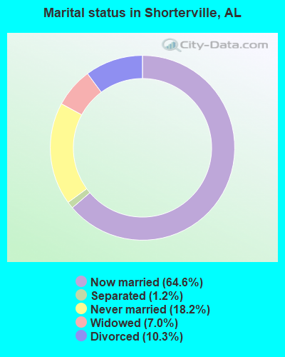
- Never married: 18.2%
- Now married: 64.6%
- Separated: 1.2%
- Widowed: 7.0%
- Divorced: 10.3%
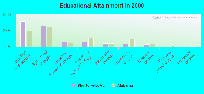
For population 25 years and over in Shorterville:
- High school or higher: 60.6%
- Bachelor's degree or higher: 8.3%
- Graduate or professional degree: 3.2%
- Unemployed: 7.6%
- Mean travel time to work (commute): 30.9 minutes
| Here: | 13.7 |
| Alabama average: | 13.2 |
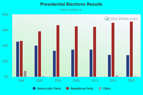
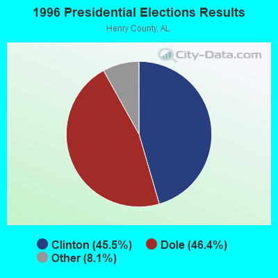
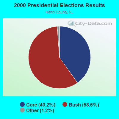
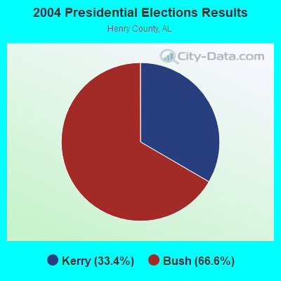
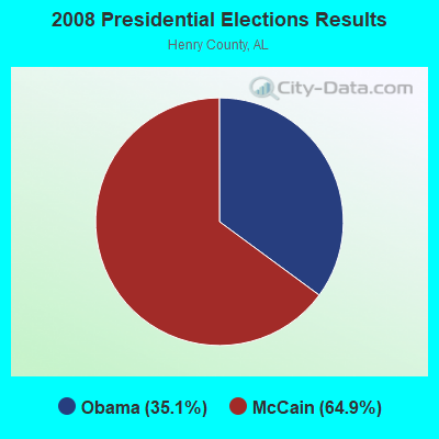

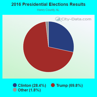

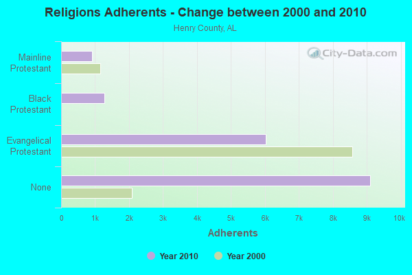
Graphs represent county-level data. Detailed 2008 Election Results
Religion statistics for Shorterville, AL (based on Henry County data)
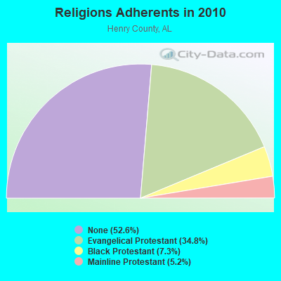
| Religion | Adherents | Congregations |
|---|---|---|
| Evangelical Protestant | 6,025 | 30 |
| Black Protestant | 1,266 | 8 |
| Mainline Protestant | 904 | 5 |
| Other | - | - |
| None | 9,107 | - |
Food Environment Statistics:
| Henry County: | 2.41 / 10,000 pop. |
| Alabama: | 1.89 / 10,000 pop. |
| Henry County: | 1.81 / 10,000 pop. |
| Alabama: | 0.65 / 10,000 pop. |
| Henry County: | 7.84 / 10,000 pop. |
| Alabama: | 6.32 / 10,000 pop. |
| Here: | 5.43 / 10,000 pop. |
| Alabama: | 5.75 / 10,000 pop. |
| This county: | 12.8% |
| Alabama: | 11.8% |
| Henry County: | 33.3% |
| State: | 31.7% |
| Henry County: | 15.9% |
| State: | 13.5% |
Strongest AM radio stations in Shorterville:
- WOOF (560 AM; 5 kW; DOTHAN, AL; Owner: WOOF, INC.)
- WQLS (1200 AM; 10 kW; OZARK, AL; Owner: STYLES BROADCASTING OF DOTHAN, INC.)
- WSTT (730 AM; 25 kW; THOMASVILLE, GA; Owner: MARION R. WILLIAMS)
- WMAC (940 AM; 50 kW; MACON, GA; Owner: CUMULUS LICENSING CORP.)
- WGST (640 AM; 50 kW; ATLANTA, GA; Owner: CITICASTERS LICENSES, L.P.)
- WDAK (540 AM; 5 kW; COLUMBUS, GA; Owner: CLEAR CHANNEL BROADCASTING LICENSES, INC.)
- WJOX (690 AM; 50 kW; BIRMINGHAM, AL; Owner: CITADEL BROADCASTING COMPANY)
- WSB (750 AM; 50 kW; ATLANTA, GA; Owner: CXR HOLDINGS, INC.)
- WCNN (680 AM; 50 kW; NORTH ATLANTA, GA; Owner: DICKEY BROADCASTING COMPANY)
- WNSI (810 AM; 50 kW; JACKSONVILLE, AL; Owner: UNITED BROADCASTING NETWORK, INC.)
- WKNG (1060 AM; daytime; 50 kW; TALLAPOOSA, GA; Owner: WKNG, INC.)
- WGUN (1010 AM; 50 kW; ATLANTA, GA; Owner: WGUN, INC.)
- WTBF (970 AM; 5 kW; TROY, AL; Owner: TROY BROADCASTING CORP.)
Strongest FM radio stations in Shorterville:
- WJWV (90.9 FM; FORT GAINES, GA; Owner: GEORGIA PUBLIC TELECOMMUNICATIONS COMMISSION)
- WTVY-FM (95.5 FM; DOTHAN, AL; Owner: STYLES BROADCASTING OF DOTHAN, INC.)
- WIZB (94.3 FM; ABBEVILLE, AL; Owner: CELEBRATIONS COMMUNICATIONS COMPANY, INC.)
- WIOL (92.7 FM; EUFAULA, AL; Owner: HATCHEE CREEK COMMUNICATIONS, INC.)
- WOOF-FM (99.7 FM; DOTHAN, AL; Owner: WOOF, INC.)
- WRAK-FM (97.3 FM; BAINBRIDGE, GA; Owner: CLEAR CHANNEL BROADCASTING LICENSES, INC.)
- W220BI (91.9 FM; EUFAULA, AL; Owner: MONTGOMERY CHRISTIAN EDUC., RADIO)
- WESP (102.5 FM; DOTHAN, AL; Owner: GULF SOUTH COMMUNICATIONS, INC)
- WAGF-FM (101.3 FM; DOTHAN, AL; Owner: WILSON BROADCASTING CO., INC.)
- WRVX (97.9 FM; EUFAULA, AL; Owner: RIVER VALLEY MEDIA, L.L.C.)
TV broadcast stations around Shorterville:
- WGIQ (Channel 43; LOUISVILLE, AL; Owner: ALABAMA EDUCATIONAL TELEVISION COMMISSION)
- WTVM (Channel 9; COLUMBUS, GA; Owner: RAYCOM AMERICA, INC.)
- WRBL (Channel 3; COLUMBUS, GA; Owner: MEDIA GENERAL BROADCASTING OF SO. CAROLINA HOLDINGS, INC.)
- WTVY (Channel 4; DOTHAN, AL; Owner: GRAY MIDAMERICA TV LICENSEE CORP.)
- WACS-TV (Channel 25; DAWSON, GA; Owner: GEORGIA PUBLIC TELECOMMUNICATIONS COMMISSION)
- WDHN (Channel 18; DOTHAN, AL; Owner: MORRIS NETWORK OF ALABAMA, INC.)
- WDFX-TV (Channel 34; OZARK, AL; Owner: WAITT LICENSE CO. OF ALABAMA, L.L.C.)
- W30BD (Channel 30; EUFAULA, AL; Owner: TRINITY BROADCASTING NETWORK)
FCC Registered Antenna Towers:
12 (See the full list of FCC Registered Antenna Towers in Shorterville)FCC Registered Broadcast Land Mobile Towers:
1- Alabama Hwy 10 .5 Mi N (Lat: 31.576556 Lon: -85.113250), Call Sign: KIS416, Licensee ID: L00014074,
Assigned Frequencies: 151.715 MHz, Grant Date: 04/24/1997, Expiration Date: 06/24/2002, Cancellation Date: 10/27/2002, Registrant: Robert E Phillips Jr, General Delivery, Shorterville, AL 36373, Phone: (205) 585-2018
FCC Registered Microwave Towers:
2- Walter F George Dam, Walter F George Dam (Lat: 31.624361 Lon: -85.065528), Type: Gtower, Structure height: 18.3 m, Overall height: 21.3 m, Call Sign: WQQB397,
Assigned Frequencies: 957.550 MHz, Grant Date: 10/15/2012, Expiration Date: 10/15/2022, Cancellation Date: 07/21/2022, Certifier: Larry F Butts, Registrant: Southern Company Services, 600 N. 18th St / Bin 5n-5409, Birmingham, AL 35203, Phone: (205) 257-7600, Fax: (205) 257-2134, Email:
- 9BH0617A, 8971 Sr-10 (Bh0617) (Lat: 31.578861 Lon: -85.094778), Type: Ltower, Structure height: 91.4 m, Overall height: 94.5 m, Call Sign: WQWW974,
Assigned Frequencies: 5945.20 MHz, 6034.15 MHz, 5945.20 MHz, 6034.15 MHz, 5945.20 MHz, 6034.15 MHz, 5945.20 MHz, 6034.15 MHz, 5945.20 MHz, 6034.15 MHz... (+12 more), Grant Date: 12/14/2015, Expiration Date: 12/14/2025, Certifier: David Werblow, Registrant: T-Mobile Usa, Inc., 12920 Se 38th Street, Bellevue, WA 98006, Phone: (425) 383-8401, Fax: (425) 383-4040, Email:
FCC Registered Amateur Radio Licenses:
1- Call Sign: KI4WYV, Licensee ID: L01302849, Grant Date: 05/11/2017, Expiration Date: 07/10/2027, Certifier: Daniel J Cooper, Registrant: Daniel J Cooper, Shorterville, AL 36373-0027
FAA Registered Aircraft:
1- Aircraft: TAYLORCRAFT BC12-D (Category: Land, Seats: 2, Weight: Up to 12,499 Pounds, Speed: 78 mph), Engine: CONT MOTOR A&C65 SERIES (65 HP) (Reciprocating)
N-Number: 43837, N43837, N-43837, Serial Number: 7496, Year manufactured: 1946, Airworthiness Date: 01/28/1957, Certificate Issue Date: 04/22/2015
Registrant (Individual): Marvin Rossen Jr Barnes, 3475 County Road 71, Shorterville, AL 36373
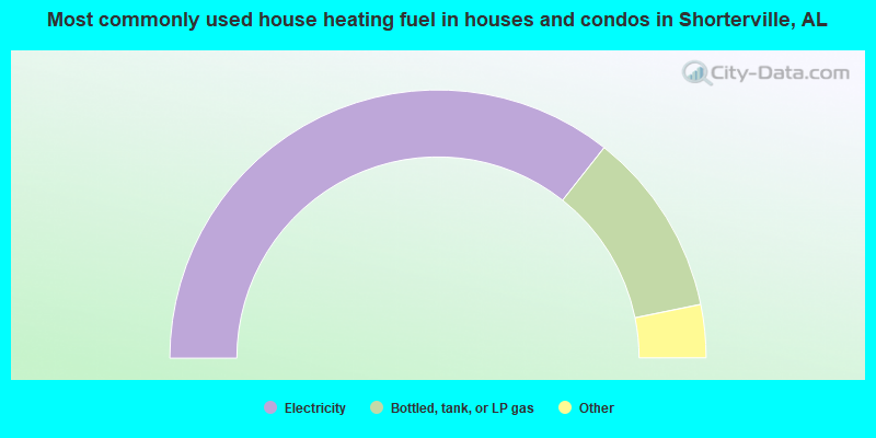
- 71.3%Electricity
- 22.3%Bottled, tank, or LP gas
- 2.0%Fuel oil, kerosene, etc.
- 2.0%Wood
- 1.9%Utility gas
- 0.7%Other fuel
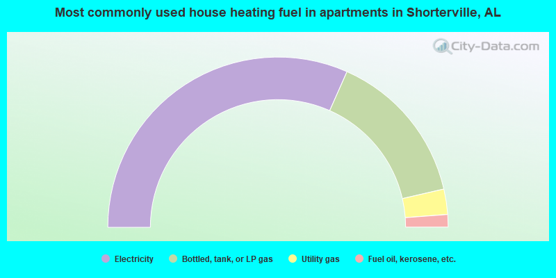
- 63.3%Electricity
- 29.5%Bottled, tank, or LP gas
- 4.8%Utility gas
- 2.4%Fuel oil, kerosene, etc.
Shorterville compared to Alabama state average:
- Unemployed percentage below state average.
- Hispanic race population percentage below state average.
- Foreign-born population percentage significantly below state average.
- Renting percentage below state average.
- Length of stay since moving in significantly above state average.
- Number of rooms per house significantly below state average.
- House age significantly below state average.
- Number of college students below state average.
- Percentage of population with a bachelor's degree or higher significantly below state average.
Shorterville on our top lists:
- #98 on the list of "Top 101 cities with the largest percentage of mobile homes (2,000+ housing units)"