Snake River, Washington
Submit your own pictures of this place and show them to the world
- OSM Map
- General Map
- Google Map
- MSN Map

| Males: 192 | |
| Females: 172 |
| Median resident age: | 39.5 years |
| Washington median age: | 35.3 years |
Zip code: 99347
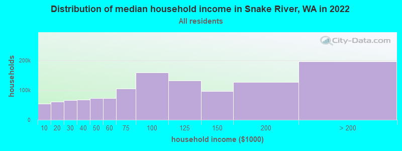
| Snake River: | $62,933 |
| WA: | $91,306 |
Estimated per capita income in 2022: $34,279 (it was $17,912 in 2000)
Snake River CCD income, earnings, and wages data
Estimated median house or condo value in 2022: $403,549 (it was $125,000 in 2000)
| Snake River: | $403,549 |
| WA: | $569,500 |
Mean prices in 2022: all housing units: $245,961; detached houses: $286,641; mobile homes: $91,189
Detailed information about poverty and poor residents in Snake River, WA
Compare current foreclosures near Snake River, WA:
| Photo | Address | Area | Beds / Baths | Price | Details |
|---|---|---|---|---|---|

|
#1
Main St
Pomeroy, WA 99347
|
- sq. feet
|
- baths - beds |
show details | |

|
Check over 1 million property listings on Foreclosure.com!
|
browse all offers | |||

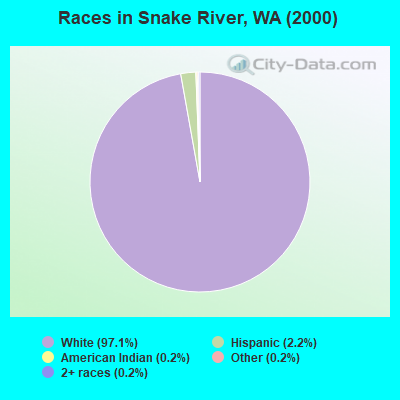
- 40497.1%White alone
- 92.2%Hispanic
- 10.2%American Indian alone
- 10.2%Other race alone
- 10.2%Two or more races
Races in Snake River detailed stats: ancestries, foreign born residents, place of birth
 Recent articles from our blog. Our writers, many of them Ph.D. graduates or candidates, create easy-to-read articles on a wide variety of topics.
Current Local Time: PST time zone
Land area: 506.0 square miles.
Population density: 0.7 people per square mile (very low).

| Snake River CCD: | 1.2% ($1,455) |
| Washington: | 1.2% ($1,915) |
Nearest city with pop. 50,000+: Kennewick, WA  (80.5 miles , pop. 54,693).
Nearest city with pop. 200,000+: East Seattle, WA (236.2 miles , pop. 480,100).
Nearest city with pop. 1,000,000+: Los Angeles, CA (851.8 miles , pop. 3,694,820).
Nearest cities:
), Latitude: 46.38 N, Longitude: 117.50 W
Area code commonly used in this area: 509

| Here: | 5.3% |
| Washington: | 4.6% |
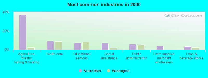
- Agriculture, forestry, fishing & hunting (37.1%)
- Health care (9.0%)
- Educational services (7.2%)
- Social assistance (6.8%)
- Public administration (5.9%)
- Farm supplies merchant wholesalers (4.1%)
- Food & beverage stores (3.6%)
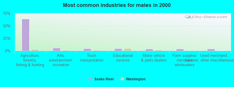
- Agriculture, forestry, fishing & hunting (64.2%)
- Arts, entertainment, recreation (5.7%)
- Truck transportation (4.9%)
- Educational services (4.9%)
- Motor vehicle & parts dealers (4.1%)
- Farm supplies merchant wholesalers (4.1%)
- Used merchandise, gift, novelty, souvenir, other miscellaneous stores (4.1%)
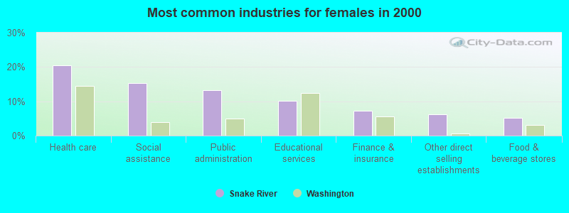
- Health care (20.4%)
- Social assistance (15.3%)
- Public administration (13.3%)
- Educational services (10.2%)
- Finance & insurance (7.1%)
- Other direct selling establishments (6.1%)
- Food & beverage stores (5.1%)
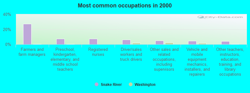
- Farmers and farm managers (27.1%)
- Preschool, kindergarten, elementary, and middle school teachers (7.2%)
- Registered nurses (7.2%)
- Driver/sales workers and truck drivers (6.3%)
- Other sales and related occupations, including supervisors (5.0%)
- Vehicle and mobile equipment mechanics, installers, and repairers (4.5%)
- Other teachers, instructors, education, training, and library occupations (4.1%)
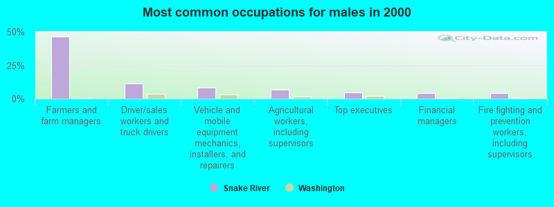
- Farmers and farm managers (46.3%)
- Driver/sales workers and truck drivers (11.4%)
- Vehicle and mobile equipment mechanics, installers, and repairers (8.1%)
- Agricultural workers, including supervisors (6.5%)
- Top executives (4.9%)
- Financial managers (4.1%)
- Fire fighting and prevention workers, including supervisors (4.1%)
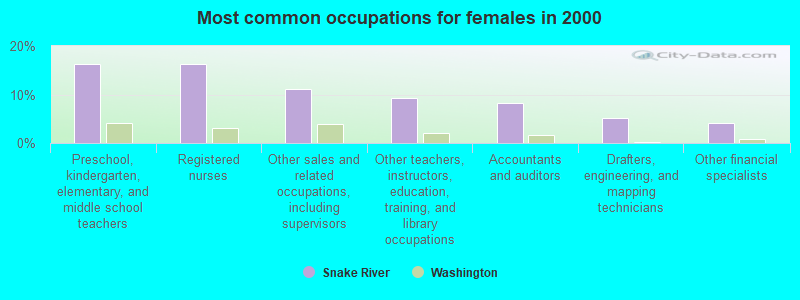
- Preschool, kindergarten, elementary, and middle school teachers (16.3%)
- Registered nurses (16.3%)
- Other sales and related occupations, including supervisors (11.2%)
- Other teachers, instructors, education, training, and library occupations (9.2%)
- Accountants and auditors (8.2%)
- Drafters, engineering, and mapping technicians (5.1%)
- Other financial specialists (4.1%)
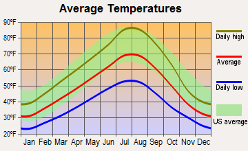
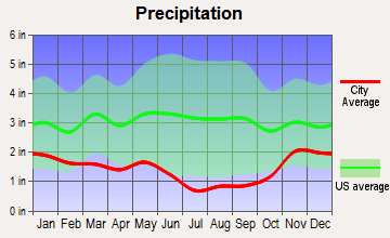
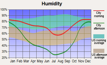
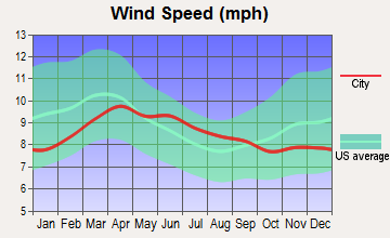
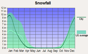
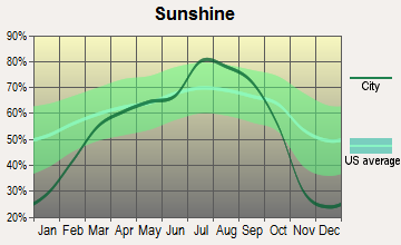
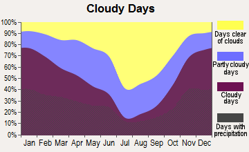
Average climate in Snake River, Washington
Based on data reported by over 4,000 weather stations
(lower is better)
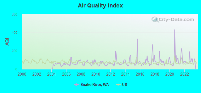
Air Quality Index (AQI) level in 2022 was 86.8. This is about average.
| City: | 86.8 |
| U.S.: | 72.6 |
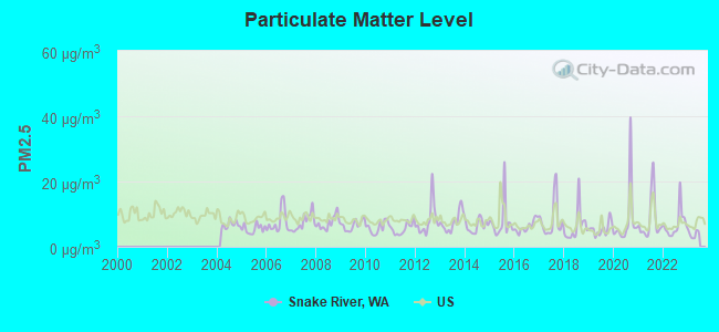
Particulate Matter (PM2.5) [µg/m3] level in 2022 was 6.90. This is about average. Closest monitor was 21.0 miles away from the city center.
| City: | 6.90 |
| U.S.: | 8.11 |
Earthquake activity:
Snake River-area historical earthquake activity is significantly above Washington state average. It is 1143% greater than the overall U.S. average.On 10/28/1983 at 14:06:06, a magnitude 7.3 (6.2 MB, 7.3 MS, 7.0 MW, Class: Major, Intensity: VIII - XII) earthquake occurred 240.4 miles away from the city center, causing 2 deaths (2 shaking deaths) and 3 injuries, causing $15,000,000 total damage
On 8/18/1959 at 06:37:13, a magnitude 7.7 (7.7 UK) earthquake occurred 354.7 miles away from Snake River center, causing $26,000,000 total damage
On 4/13/1949 at 19:55:42, a magnitude 7.0 (7.0 UK) earthquake occurred 244.3 miles away from Snake River center, causing $80,000,000 total damage
On 3/31/2020 at 23:52:30, a magnitude 6.5 (6.5 MW, Depth: 7.5 mi, Class: Strong, Intensity: VII - IX) earthquake occurred 175.9 miles away from Snake River center
On 10/3/1915 at 06:52:48, a magnitude 7.6 (7.6 UK) earthquake occurred 407.0 miles away from Snake River center
On 2/28/2001 at 18:54:32, a magnitude 6.8 (6.5 MB, 6.6 MS, 6.8 MW) earthquake occurred 245.9 miles away from the city center, causing $2,000,000,000 total damage and $305,000,000 insured losses
Magnitude types: body-wave magnitude (MB), surface-wave magnitude (MS), moment magnitude (MW)
Natural disasters:
The number of natural disasters in Garfield County (13) is near the US average (15).Major Disasters (Presidential) Declared: 10
Emergencies Declared: 1
Causes of natural disasters: Floods: 8, Mudslides: 4, Storms: 4, Landslides: 3, Winter Storms: 3, Heavy Rains: 2, Snows: 2, Fire: 1, Hurricane: 1, Volcanic Eruption: 1, Wind: 1, Other: 1 (Note: some incidents may be assigned to more than one category).
Colleges/universities with over 2000 students nearest to Snake River:
- Lewis-Clark State College (about 23 miles; Lewiston, ID; Full-time enrollment: 3,199)
- Washington State University (about 29 miles; Pullman, WA; FT enrollment: 25,055)
- University of Idaho (about 33 miles; Moscow, ID; FT enrollment: 10,416)
- Walla Walla Community College (about 44 miles; Walla Walla, WA; FT enrollment: 4,263)
- Eastern Washington University (about 77 miles; Cheney, WA; FT enrollment: 11,643)
- Columbia Basin College (about 79 miles; Pasco, WA; FT enrollment: 5,111)
- Eastern Oregon University (about 79 miles; La Grande, OR; FT enrollment: 3,127)
Points of interest:
Notable locations in Snake River: Alder Thicket Campground (A), Offield Landing (B), Willow Landing (C), H A McEachan Ranch (D), F Kessler Ranch (E), Pataha Research Natural Area (F), Columbia Center (G), First Creek Cabin (H), Misery Spring Campground (I), Pataha Campground (J), Powell Camp (K), Ruchert Camp (L), Clearwater Lookout (M), Cecil Bott Ranch (N), C H Neal Ranch (O), J R Evans Ranch (P), Sheephead Corral (Q), Spruce Spring Campground (R), Valentine (S), Wickiup Campground (T). Display/hide their locations on the map
Cemeteries: Kirby Cemetery (1), Mayview Cemetery (2), Pioneer Cemetery (3). Display/hide their locations on the map
Creeks: Bear Creek (A), Casey Creek (B), Cherry Creek (C), Coyote Creek (D), Donaldson Creek (E), Dry Pataha Creek (F), First Creek (G), Meadow Creek (H), Melton Creek (I). Display/hide their locations on the map
Park in Snake River: Grouse Flat State Wildlife Recreation Area (1). Display/hide its location on the map
| This place: | 2.5 people |
| Washington: | 2.5 people |
| This place: | 73.0% |
| Whole state: | 64.4% |
| This place: | 3.8% |
| Whole state: | 7.7% |
No gay or lesbian households reported
| This place: | 17.5% |
| Whole state: | 10.6% |
| This place: | 11.6% |
| Whole state: | 4.6% |
For population 15 years and over in Snake River:
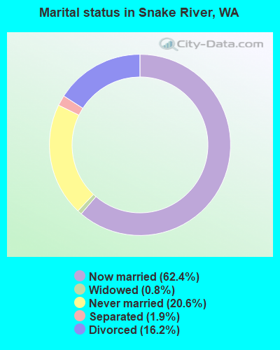
- Never married: 20.6%
- Now married: 62.4%
- Separated: 1.9%
- Widowed: 0.8%
- Divorced: 16.2%
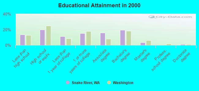
For population 25 years and over in Snake River:
- High school or higher: 86.2%
- Bachelor's degree or higher: 24.2%
- Graduate or professional degree: 4.7%
- Mean travel time to work (commute): 19.6 minutes
| Here: | 10.6 |
| Washington average: | 11.3 |
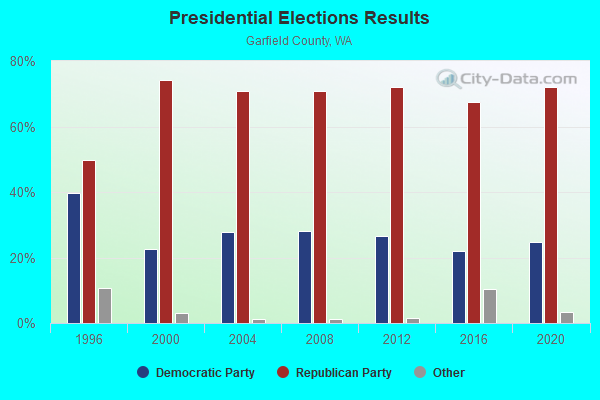
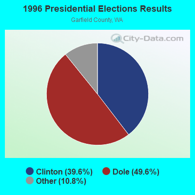


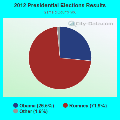

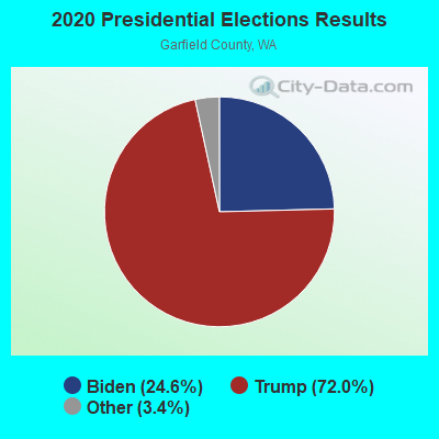
Graphs represent county-level data. Detailed 2008 Election Results
Religion statistics for Snake River, WA (based on Garfield County data)
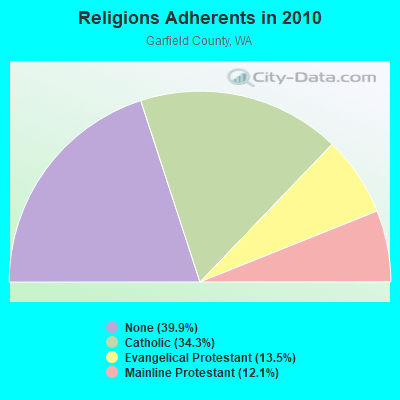
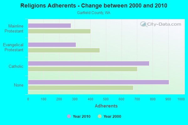
| Religion | Adherents | Congregations |
|---|---|---|
| Catholic | 777 | 1 |
| Evangelical Protestant | 307 | 2 |
| Mainline Protestant | 275 | 2 |
| Other | 2 | - |
| None | 905 | - |
Food Environment Statistics:
| Garfield County: | 4.89 / 10,000 pop. |
| State: | 2.06 / 10,000 pop. |
| Garfield County: | 14.68 / 10,000 pop. |
| Washington: | 8.26 / 10,000 pop. |
| Garfield County: | 11.7% |
| Washington: | 7.7% |
| This county: | 29.9% |
| State: | 25.7% |
Strongest AM radio stations in Snake River:
- KQQQ (1150 AM; 25 kW; PULLMAN, WA; Owner: RADIO PALOUSE, INC.)
- KOZE (950 AM; 5 kW; LEWISTON, ID; Owner: 4-K RADIO, INC.)
- KMAX (840 AM; 10 kW; COLFAX, WA; Owner: PALOUSE COUNTRY, INC.)
- KCLK (1430 AM; 5 kW; ASOTIN, WA; Owner: CLARKSTON BROADCASTERS, INC.)
- KWSU (1250 AM; 5 kW; PULLMAN, WA; Owner: WASHINGTON STATE UNIVERSITY)
- KRLC (1350 AM; 5 kW; CLARKSTON LEWISTON,, WA; Owner: IDA-VEND COMPANY, INC.)
- KGA (1510 AM; 50 kW; SPOKANE, WA; Owner: CITADEL BROADCASTING COMPANY)
- KTBI (810 AM; daytime; 50 kW; EPHRATA, WA; Owner: TACOMA BROADCASTERS, INCORPORATED)
- KXLY (920 AM; 20 kW; SPOKANE, WA; Owner: SPOKANE RADIO, INC.)
- KERR (750 AM; 50 kW; POLSON, MT; Owner: ANDERSON RADIO BROADCASTING, INC.)
- KMJY (700 AM; 10 kW; NEWPORT, WA; Owner: JAMES E. AND HELEN G. STARGEL)
- KFLD (870 AM; 10 kW; PASCO, WA; Owner: CAPSTAR TX LIMITED PARTNERSHIP)
- KWEI (1260 AM; 50 kW; WEISER, ID; Owner: TREASURE VALLEY BROADCASTING CO.)
Strongest FM radio stations in Snake River:
- KCLK-FM (94.1 FM; CLARKSTON, WA; Owner: CLARKSTON BROADCASTERS, INC.)
- KVAB (102.9 FM; CLARKSTON, WA; Owner: CLARKSTON BROADCASTERS, INC.)
- KNWV (90.5 FM; CLARKSTON, WA; Owner: WASHINGTON STATE UNIVERSITY)
- KMOK (106.9 FM; LEWISTON, ID; Owner: IDA-VEND COMPANY, INC.)
- KZHR (92.5 FM; DAYTON, WA; Owner: COMMONWEALTH LICENSE SUBSIDIARY, LLC)
- KVTY (105.1 FM; LEWISTON, ID; Owner: IDAVEND CO. INC.)
- KOZE-FM (96.5 FM; LEWISTON, ID; Owner: 4-K RADIO, INC.)
- KATW (101.5 FM; LEWISTON, ID; Owner: PACIFIC EMPIRE COMMUNICATIONS CORP.)
- KHTR (104.3 FM; PULLMAN, WA; Owner: RADIO PALOUSE, INC.)
- KRLF (88.5 FM; PULLMAN, WA; Owner: LIVING FAITH F/SHIP EDUC. MINISTRIES)
- KZZL-FM (99.5 FM; PULLMAN, WA; Owner: PALOUSE COUNTRY, INC.)
- KNWO (90.1 FM; COTTONWOOD, ID; Owner: WASHINGTON STATE UNIVERSITY)
- KNLT (95.7 FM; WALLA WALLA, WA; Owner: NEW NORTHWEST BROADCASTERS, LLC)
- KZFN (106.1 FM; MOSCOW, ID; Owner: KRPL, INC.)
- KUBQ (98.7 FM; LA GRANDE, OR; Owner: GRANDE RADIO, INC.)
- KWWS (89.7 FM; WALLA WALLA, WA; Owner: WASHINGTON STATE UNIVERSITY)
- KRFA-FM (91.7 FM; MOSCOW, ID; Owner: WASHINGTON STATE UNIVERSITY)
- KRAO-FM (102.5 FM; COLFAX, WA; Owner: PALOUSE COUNTRY, INC.)
- KGTS (91.3 FM; COLLEGE PLACE, WA; Owner: WALLA WALLA COLLEGE)
- KHSS (100.7 FM; WALLA WALLA, WA; Owner: TWO HEARTS COMMUNICATIONS, LLC)
TV broadcast stations around Snake River:
- KLEW-TV (Channel 3; LEWISTON, ID; Owner: FISHER BROADCASTING - WASHINGTON TV, L.L.C.)
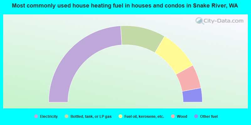
- 48.0%Electricity
- 19.0%Bottled, tank, or LP gas
- 17.0%Fuel oil, kerosene, etc.
- 10.0%Wood
- 6.0%Other fuel
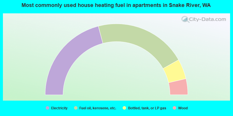
- 41.8%Electricity
- 41.8%Fuel oil, kerosene, etc.
- 9.1%Bottled, tank, or LP gas
- 7.3%Wood
Snake River compared to Washington state average:
- Unemployed percentage significantly below state average.
- Black race population percentage significantly below state average.
- Hispanic race population percentage significantly below state average.
- Median age above state average.
- Foreign-born population percentage significantly below state average.
- Length of stay since moving in significantly above state average.
- Number of rooms per house significantly below state average.
- House age significantly below state average.