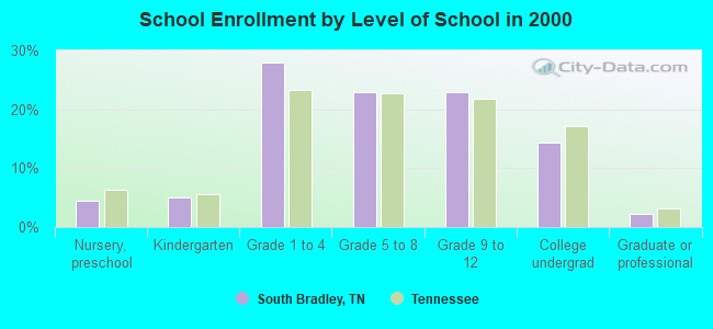
South Bradley, Tennessee
Submit your own pictures of this place and show them to the world
- OSM Map
- General Map
- Google Map
- MSN Map

| Males: 3,648 | |
| Females: 3,589 |
| Median resident age: | 37.3 years |
| Tennessee median age: | 35.9 years |
Zip code: 37311
| South Bradley: | $72,437 |
| TN: | $65,254 |
Estimated per capita income in 2022: $30,037 (it was $17,493 in 2000)
South Bradley CCD income, earnings, and wages data
Estimated median house or condo value in 2022: $264,314 (it was $95,300 in 2000)
| South Bradley: | $264,314 |
| TN: | $284,800 |
Mean prices in 2022: all housing units: $261,195; detached houses: $277,566; townhouses or other attached units: $186,044; in 2-unit structures: $169,221; mobile homes: $91,385
Detailed information about poverty and poor residents in South Bradley, TN


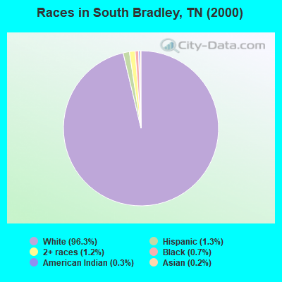
- 6,43796.3%White alone
- 841.3%Hispanic
- 801.2%Two or more races
- 460.7%Black alone
- 210.3%American Indian alone
- 110.2%Asian alone
- 60.09%Other race alone
Races in South Bradley detailed stats: ancestries, foreign born residents, place of birth
 Recent articles from our blog. Our writers, many of them Ph.D. graduates or candidates, create easy-to-read articles on a wide variety of topics.
Current Local Time: EST time zone
Land area: 67.5 square miles.
Population density: 107 people per square mile (very low).

| South Bradley CCD: | 0.6% ($573) |
| Tennessee: | 0.8% ($715) |
Nearest city with pop. 50,000+: Chattanooga, TN  (19.2 miles , pop. 155,554).
Nearest city with pop. 200,000+: Atlanta, GA (95.3 miles , pop. 416,474).
Nearest city with pop. 1,000,000+: Chicago, IL (491.5 miles , pop. 2,896,016).
Nearest cities:
), ), ), ), ), Latitude: 35.07 N, Longitude: 84.93 W
Area code commonly used in this area: 423

| Here: | 3.1% |
| Tennessee: | 3.0% |
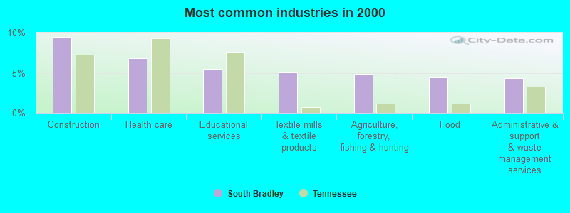
- Construction (9.5%)
- Health care (6.8%)
- Educational services (5.5%)
- Textile mills & textile products (5.0%)
- Agriculture, forestry, fishing & hunting (4.8%)
- Food (4.4%)
- Administrative & support & waste management services (4.3%)
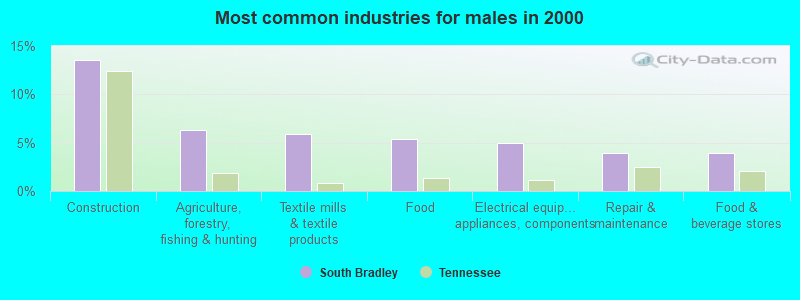
- Construction (13.6%)
- Agriculture, forestry, fishing & hunting (6.4%)
- Textile mills & textile products (5.9%)
- Food (5.4%)
- Electrical equipment, appliances, components (4.9%)
- Repair & maintenance (4.0%)
- Food & beverage stores (3.9%)
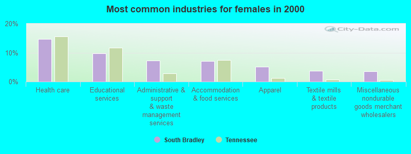
- Health care (14.7%)
- Educational services (9.8%)
- Administrative & support & waste management services (7.3%)
- Accommodation & food services (7.1%)
- Apparel (5.1%)
- Textile mills & textile products (3.7%)
- Miscellaneous nondurable goods merchant wholesalers (3.6%)
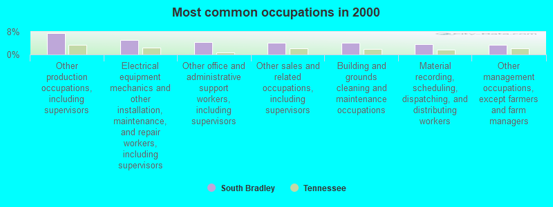
- Other production occupations, including supervisors (7.4%)
- Electrical equipment mechanics and other installation, maintenance, and repair workers, including supervisors (5.1%)
- Other office and administrative support workers, including supervisors (4.3%)
- Other sales and related occupations, including supervisors (4.2%)
- Building and grounds cleaning and maintenance occupations (4.2%)
- Material recording, scheduling, dispatching, and distributing workers (3.7%)
- Other management occupations, except farmers and farm managers (3.5%)
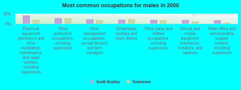
- Electrical equipment mechanics and other installation, maintenance, and repair workers, including supervisors (8.6%)
- Other production occupations, including supervisors (6.0%)
- Other management occupations, except farmers and farm managers (4.7%)
- Driver/sales workers and truck drivers (4.7%)
- Other sales and related occupations, including supervisors (4.3%)
- Vehicle and mobile equipment mechanics, installers, and repairers (4.1%)
- Other office and administrative support workers, including supervisors (3.9%)
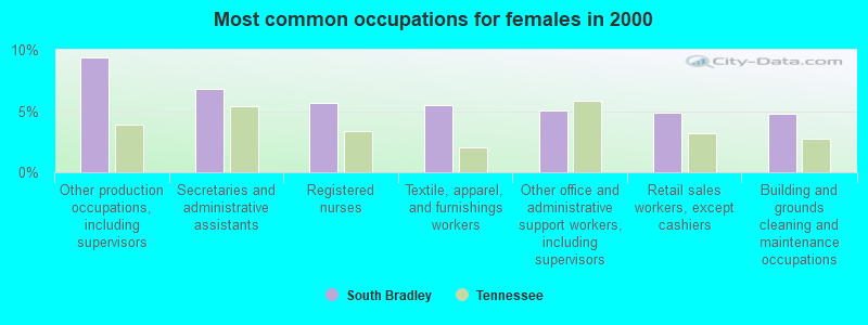
- Other production occupations, including supervisors (9.4%)
- Secretaries and administrative assistants (6.8%)
- Registered nurses (5.6%)
- Textile, apparel, and furnishings workers (5.5%)
- Other office and administrative support workers, including supervisors (5.0%)
- Retail sales workers, except cashiers (4.9%)
- Building and grounds cleaning and maintenance occupations (4.8%)
Average climate in South Bradley, Tennessee
Based on data reported by over 4,000 weather stations


(lower is better)
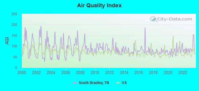
Air Quality Index (AQI) level in 2023 was 94.7. This is worse than average.
| City: | 94.7 |
| U.S.: | 72.6 |
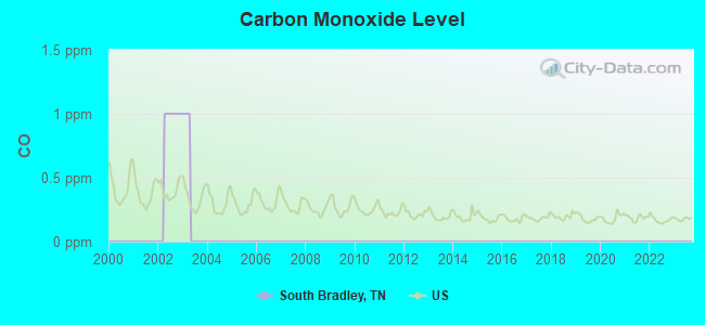
Carbon Monoxide (CO) [ppm] level in 2002 was 1.00. This is significantly worse than average. Closest monitor was 15.4 miles away from the city center.
| City: | 1.00 |
| U.S.: | 0.25 |
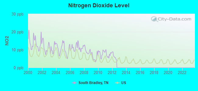
Nitrogen Dioxide (NO2) [ppb] level in 2012 was 6.38. This is worse than average. Closest monitor was 12.0 miles away from the city center.
| City: | 6.38 |
| U.S.: | 5.11 |
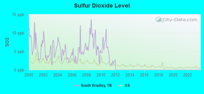
Sulfur Dioxide (SO2) [ppb] level in 2011 was 2.26. This is significantly worse than average. Closest monitor was 12.0 miles away from the city center.
| City: | 2.26 |
| U.S.: | 1.51 |
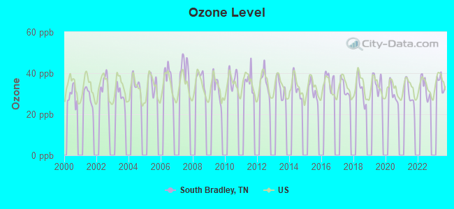
Ozone [ppb] level in 2023 was 35.3. This is about average. Closest monitor was 12.6 miles away from the city center.
| City: | 35.3 |
| U.S.: | 33.3 |
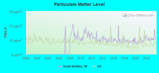
Particulate Matter (PM2.5) [µg/m3] level in 2023 was 11.7. This is significantly worse than average. Closest monitor was 18.3 miles away from the city center.
| City: | 11.7 |
| U.S.: | 8.1 |
Tornado activity:
South Bradley-area historical tornado activity is near Tennessee state average. It is 31% greater than the overall U.S. average.
On 4/3/1974, a category F4 (max. wind speeds 207-260 mph) tornado 22.6 miles away from the South Bradley place center killed 9 people and injured 67 people and caused between $500,000 and $5,000,000 in damages.
On 4/3/1974, a category F3 (max. wind speeds 158-206 mph) tornado 2.3 miles away from the place center killed one person and injured 100 people and caused between $50,000 and $500,000 in damages.
Earthquake activity:
South Bradley-area historical earthquake activity is significantly above Tennessee state average. It is 103% greater than the overall U.S. average.On 4/29/2003 at 08:59:39, a magnitude 4.9 (4.4 MB, 4.6 MW, 4.9 LG, Class: Light, Intensity: IV - V) earthquake occurred 56.2 miles away from South Bradley center
On 11/30/1973 at 07:48:41, a magnitude 4.7 (4.7 MB, 4.6 ML) earthquake occurred 74.4 miles away from the city center
On 4/29/2003 at 08:59:39, a magnitude 4.6 (4.6 MW, Depth: 12.3 mi) earthquake occurred 56.2 miles away from the city center
On 12/12/2018 at 09:14:43, a magnitude 4.4 (4.4 MW, Depth: 4.9 mi) earthquake occurred 39.3 miles away from the city center
On 8/2/1974 at 08:52:09, a magnitude 4.9 (4.3 MB, 4.9 LG) earthquake occurred 161.9 miles away from the city center
On 7/27/1980 at 18:52:21, a magnitude 5.2 (5.1 MB, 4.7 MS, 5.0 UK, 5.2 UK, Class: Moderate, Intensity: VI - VII) earthquake occurred 223.8 miles away from the city center
Magnitude types: regional Lg-wave magnitude (LG), body-wave magnitude (MB), local magnitude (ML), surface-wave magnitude (MS), moment magnitude (MW)
Natural disasters:
The number of natural disasters in Bradley County (14) is near the US average (15).Major Disasters (Presidential) Declared: 10
Emergencies Declared: 2
Causes of natural disasters: Floods: 7, Storms: 7, Tornadoes: 7, Winds: 3, Flash Floods: 2, Heavy Rains: 2, Winter Storms: 2, Hurricane: 1, Ice Storm: 1, Snowfall: 1, Other: 1 (Note: some incidents may be assigned to more than one category).
Hospitals and medical centers near South Bradley:
- LIFE CARE CENTER OF CLEVELAND (Nursing Home, about 6 miles away; CLEVELAND, TN)
- HOME CARE SOLUTIONS (Home Health Center, about 8 miles away; OOLTEWAH, TN)
- OPEN ARMS CARE CORP SITE #14 (Hospital, about 8 miles away; OOLTEWAH, TN)
- LIFE CARE CTR OF COLLEGEDALE (Nursing Home, about 9 miles away; COLLEGEDALE, TN)
- KIDNEY CENTER OF CLEVELAND (Dialysis Facility, about 9 miles away; CLEVELAND, TN)
- BRADLEY COUNTY MEMORIAL HOSPITAL (Hospital, about 9 miles away; CLEVELAND, TN)
- SKYRIDGE MEDICAL CENTER Acute Care Hospitals (about 9 miles away; CLEVELAND, TN)
Operable nuclear power plants near South Bradley:
- 20 miles: Sequoyah 1 and 2 in Soddy-Daisy, TN.
Colleges/universities with over 2000 students nearest to South Bradley:
- Southern Adventist University (about 8 miles; Collegedale, TN; Full-time enrollment: 2,898)
- Lee University (about 8 miles; Cleveland, TN; FT enrollment: 4,422)
- Cleveland State Community College (about 10 miles; Cleveland, TN; FT enrollment: 2,500)
- Chattanooga State Community College (about 18 miles; Chattanooga, TN; FT enrollment: 6,827)
- Dalton State College (about 21 miles; Dalton, GA; FT enrollment: 3,846)
- The University of Tennessee-Chattanooga (about 22 miles; Chattanooga, TN; FT enrollment: 10,158)
- Berry College (about 56 miles; Mount Berry, GA; FT enrollment: 2,102)
Points of interest:
Notable locations in South Bradley: Weatherly Switch (A), Red Clay Council Grounds (B), Cleveland-Bradley County Industrial Park (C), Marble Switch (D), Hidden Valley Camp (E), Bradley County Fire and Rescue Station 3 (F). Display/hide their locations on the map
Churches in South Bradley include: Black Fox Methodist Church (A), Bethel Baptist Church (B), Flint Springs Presbyterian Church (C), Lebanon Church (D), Pine Hill Church of God (E), Pine Hill Presbyterian Church (F), Red Hill Methodist Church (G), Antioch Baptist Church (H), Coahulla Baptist Church (I). Display/hide their locations on the map
Cemeteries: Tucker Cemetery (1), Lee Cemetery (2), Loftis Cemetery (3), Lusk Cemetery (4), Taylor Cemetery (5), Triplett Cemetery (6), McKamey Cemetery (7). Display/hide their locations on the map
Reservoir: Davis Lake (A). Display/hide its location on the map
Streams, rivers, and creeks: Johnson Branch (A), Jerry Branch (B), Dry Creek (C), Drumgool Creek (D), Brymer Creek (E), Blue Springs Branch (F), Black Fox Creek (G), Phillips Branch (H), Allen Branch (I). Display/hide their locations on the map
Park in South Bradley: Red Clay State Historic Area (1). Display/hide its location on the map
| This place: | 2.7 people |
| Tennessee: | 2.5 people |
| This place: | 66.0% |
| Whole state: | 69.8% |
| This place: | 3.3% |
| Whole state: | 4.2% |
Likely homosexual households (counted as self-reported same-sex unmarried-partner households)
- Lesbian couples: 0.0% of all households
- Gay men: 0.1% of all households
| This place: | 9.4% |
| Whole state: | 13.5% |
| This place: | 3.5% |
| Whole state: | 5.8% |
For population 15 years and over in South Bradley:
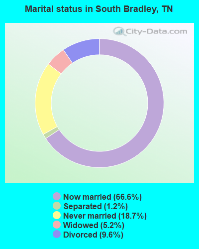
- Never married: 18.7%
- Now married: 66.6%
- Separated: 1.2%
- Widowed: 5.2%
- Divorced: 9.6%
For population 25 years and over in South Bradley:
- High school or higher: 73.3%
- Bachelor's degree or higher: 12.8%
- Graduate or professional degree: 3.3%
- Unemployed: 3.7%
- Mean travel time to work (commute): 27.7 minutes
| Here: | 13.4 |
| Tennessee average: | 13.3 |
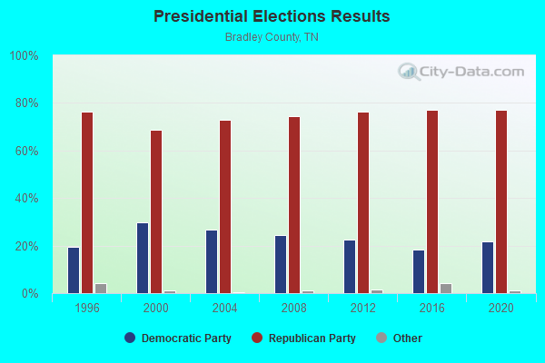
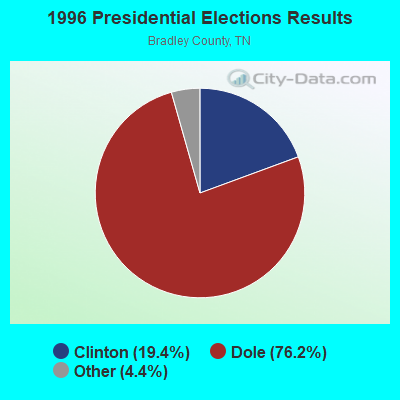

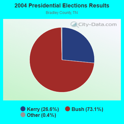
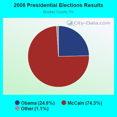
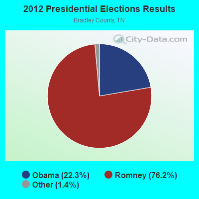
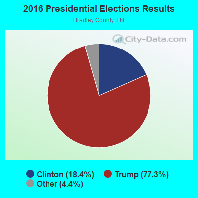
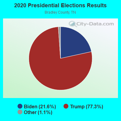
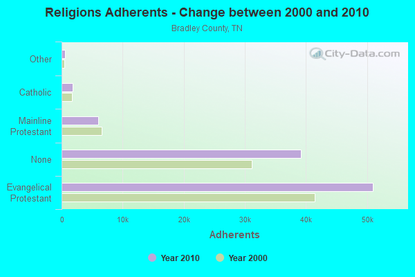
Graphs represent county-level data. Detailed 2008 Election Results
Religion statistics for South Bradley, TN (based on Bradley County data)
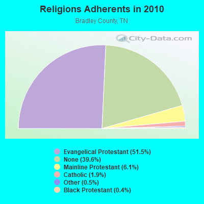
| Religion | Adherents | Congregations |
|---|---|---|
| Evangelical Protestant | 51,000 | 145 |
| Mainline Protestant | 6,000 | 25 |
| Catholic | 1,863 | 1 |
| Other | 510 | 2 |
| Black Protestant | 425 | 6 |
| None | 39,165 | - |
Food Environment Statistics:
| Bradley County: | 1.57 / 10,000 pop. |
| Tennessee: | 1.99 / 10,000 pop. |
| Here: | 0.10 / 10,000 pop. |
| State: | 0.17 / 10,000 pop. |
| This county: | 0.52 / 10,000 pop. |
| Tennessee: | 0.65 / 10,000 pop. |
| Here: | 6.82 / 10,000 pop. |
| Tennessee: | 5.16 / 10,000 pop. |
| Here: | 5.77 / 10,000 pop. |
| State: | 6.56 / 10,000 pop. |
| This county: | 12.5% |
| State: | 11.4% |
| This county: | 27.6% |
| Tennessee: | 30.2% |
| Bradley County: | 12.7% |
| Tennessee: | 13.5% |
Strongest AM radio stations in South Bradley:
- WFLI (1070 AM; 50 kW; LOOKOUT MOUNTAIN, TN; Owner: WFLI, INC.)
- WCLE (1570 AM; 5 kW; CLEVELAND, TN)
- WWAM (820 AM; daytime; 50 kW; JASPER, TN; Owner: SHELTON BROADCASTING SYSTEM)
- WTTI (1530 AM; daytime; 10 kW; DALTON, GA; Owner: PYE WILSON BROADCASTING, INC.)
- WBAC (1340 AM; 1 kW; CLEVELAND, TN; Owner: J. L. BREWER BROADCASTING OF CLEVELAND, LLC)
- WNOO (1260 AM; 5 kW; CHATTANOOGA, TN; Owner: PYE BROADCASTING, INC.)
- WCNN (680 AM; 50 kW; NORTH ATLANTA, GA; Owner: DICKEY BROADCASTING COMPANY)
- WFTD (1080 AM; daytime; 50 kW; MARIETTA, GA; Owner: PRIETO ENTERPRISES, INC.)
- WGST (640 AM; 50 kW; ATLANTA, GA; Owner: CITICASTERS LICENSES, L.P.)
- WGOW (1150 AM; 5 kW; CHATTANOOGA, TN; Owner: CITADEL BROADCASTING COMPANY)
- WKVL (850 AM; daytime; 50 kW; KNOXVILLE, TN; Owner: HORNE RADIO, LLC)
- WSB (750 AM; 50 kW; ATLANTA, GA; Owner: CXR HOLDINGS, INC.)
- WDOD (1310 AM; 5 kW; CHATTANOOGA, TN; Owner: WDOD OF CHATTANOOGA, INC.)
Strongest FM radio stations in South Bradley:
- WALV (95.3 FM; CLEVELAND, TN; Owner: J. L. BREWER BROADCASTING OF CLEVELAND, LLC)
- WSGC-FM (101.9 FM; RINGGOLD, GA; Owner: CLEAR CHANNEL BROADCASTING LICENSES, INC.)
- WUSY (100.7 FM; CLEVELAND, TN; Owner: CAPSTAR TX LIMITED PARTNERSHIP)
- W234AG (94.7 FM; CHATSWORTH, GA; Owner: IMMANUEL BROADCASTING NETWORK, INC.)
- WOCE (93.1 FM; BENTON, TN; Owner: LB RADIO OF CHATTANOOGA, LLC)
- WMBW (88.9 FM; CHATTANOOGA, TN; Owner: THE MOODY BIBLE INSTITUTE OF CHICAGO)
- WQMT (98.9 FM; CHATSWORTH, GA; Owner: CLEAR CHANNEL BROADCASTING LICENSES, INC.)
- WDEF-FM (92.3 FM; CHATTANOOGA, TN; Owner: JACKSON TELECASTERS, INC.)
- W257AZ (99.3 FM; LOOKOUT MOUNTAIN, TN; Owner: CAPSTAR TX LIMITED PARTNERSHIP)
- WSMC-FM (90.5 FM; COLLEGEDALE, TN; Owner: SOUTHERN COLLEGE OF SEVENTH-DAY ADVT)
- WDOD-FM (96.5 FM; CHATTANOOGA, TN; Owner: WDOD OF CHATTANOOGA, INC.)
- WSKZ (106.5 FM; CHATTANOOGA, TN; Owner: CITADEL BROADCASTING COMPANY)
- W217AN (91.3 FM; PROSPECT, TN; Owner: WAY-FM MEDIA GROUP, INC.)
- W260AJ (99.9 FM; RINGGOLD, GA; Owner: WCCV)
- WBDX (102.7 FM; TRENTON, GA; Owner: PARTNERS FOR CHRISTIAN RADIO, INC.)
- WOGT (107.9 FM; EAST RIDGE, TN; Owner: CITADEL BROADCASTING COMPANY)
- WCLE-FM (104.1 FM; CALHOUN, TN; Owner: WILLIAMS COMMUNICATIONS, INC.)
- WUTC (88.1 FM; CHATTANOOGA, TN; Owner: UNIVERSITY OF TENNESSEE)
- W278AC (103.5 FM; WALDEN, TN; Owner: CAPSTAR TX LIMITED PARTNERSHIP)
- W268AA (101.5 FM; FALLING WATER, TN; Owner: S/WEST FLORIDA COMMUNITY RADIO, INC.)
TV broadcast stations around South Bradley:
- WFLI-TV (Channel 53; CLEVELAND, TN; Owner: CHATTANOOGA MEDIA HOLDINGS, L.L.C.)
- W66CG (Channel 66; ACTON, TN; Owner: MS COMMUNICATIONS, LLC)
- W50AB (Channel 50; HIAWASSEE, GA; Owner: GEORGIA PUBLIC TELECOMMUNICATIONS COMMISSION)
- WDSI-TV (Channel 61; CHATTANOOGA, TN; Owner: WDSI LICENSE CORP.)
- W21BZ (Channel 21; COLLEGEDALE, TN; Owner: THREE ANGELS BROADCASTING NETWORK)
- W26BE (Channel 26; CHATTANOOGA, TN; Owner: THREE ANGELS BROADCASTING NETWORK)
- WTCI (Channel 45; CHATTANOOGA, TN; Owner: THE GREATER CHATTANOOGA PUBLIC TELEVISION CORP)
- WTNB-CA (Channel 27; CLEVELAND, TN; Owner: NORTH GEORGIA TELEVISION)
- WDEF-TV (Channel 12; CHATTANOOGA, TN; Owner: MEDIA GENERAL COMMUNICATIONS, INC.)
- WRCB-TV (Channel 3; CHATTANOOGA, TN; Owner: SARKES TARZIAN, INC.)
- WELF (Channel 23; DALTON, GA; Owner: TRINITY BROADCASTING NETWORK)
- WPDP-LP (Channel 25; CLEVELAND, TN; Owner: WDSI LICENSE CORP.)
- WRNG-LP (Channel 63; RINGGOLD, GA; Owner: NORTH GEORGIA TELEVISION)
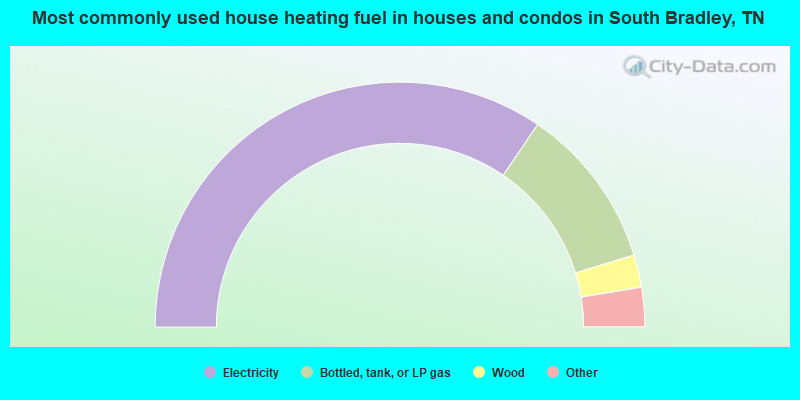
- 69.1%Electricity
- 21.5%Bottled, tank, or LP gas
- 4.3%Wood
- 2.2%Utility gas
- 1.8%Fuel oil, kerosene, etc.
- 0.8%Other fuel
- 0.4%Solar energy
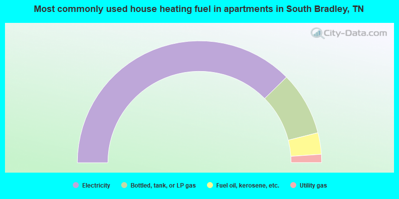
- 75.3%Electricity
- 16.9%Bottled, tank, or LP gas
- 5.7%Fuel oil, kerosene, etc.
- 2.2%Utility gas
South Bradley compared to Tennessee state average:
- Unemployed percentage significantly below state average.
- Black race population percentage significantly below state average.
- Hispanic race population percentage significantly below state average.
- Foreign-born population percentage significantly below state average.
- Renting percentage significantly below state average.
- Length of stay since moving in significantly above state average.
- Number of rooms per house significantly below state average.
- House age significantly below state average.
- Percentage of population with a bachelor's degree or higher below state average.
South Bradley on our top lists:
- #5 on the list of "Top 101 cities with largest percentage of females in industries: miscellaneous nondurable goods merchant wholesalers (population 5,000+)"
- #6 on the list of "Top 101 cities with largest percentage of males in industries: electrical equipment, appliances, and components (population 5,000+)"
- #8 on the list of "Top 101 cities with largest percentage of females in occupations: other production occupations including supervisors (population 5,000+)"
- #14 on the list of "Top 101 cities with largest percentage of females in industries: electrical equipment, appliances, and components (population 5,000+)"
- #16 on the list of "Top 101 cities with largest percentage of females in industries: apparel (population 5,000+)"
- #16 on the list of "Top 101 cities with largest percentage of females in industries: furniture and home furnishing merchant wholesalers (population 5,000+)"
- #17 on the list of "Top 101 cities with largest percentage of males in industries: religious, grantmaking, civic, professional, and similar organizations (population 5,000+)"
- #18 on the list of "Top 101 cities with largest percentage of females in industries: furniture and related product manufacturing (population 5,000+)"
- #21 on the list of "Top 101 cities with largest percentage of females in occupations: farmers and farm managers (population 5,000+)"
- #22 on the list of "Top 101 cities with largest percentage of males in industries: food (population 5,000+)"
- #23 on the list of "Top 101 cities with largest percentage of males in industries: hardware, plumbing and heating equipment, and supplies merchant wholesalers (population 5,000+)"
- #24 on the list of "Top 101 cities with largest percentage of males in industries: furniture and home furnishing merchant wholesalers (population 5,000+)"
- #26 on the list of "Top 101 cities with largest percentage of males in industries: apparel (population 5,000+)"
- #30 on the list of "Top 101 cities with largest percentage of males in industries: textile mills and textile products (population 5,000+)"
- #32 on the list of "Top 101 cities with the smallest percentage of likely homosexual households (counted as self-reported same-sex unmarried-partner households) (population 5,000+)"
- #38 on the list of "Top 101 cities with largest percentage of females in occupations: textile, apparel, and furnishings workers (population 5,000+)"
- #39 on the list of "Top 101 cities with largest percentage of females in occupations: woodworkers (population 5,000+)"
- #40 on the list of "Top 101 cities with largest percentage of males in occupations: entertainers and performers, sports, and related workers (population 5,000+)"
- #40 on the list of "Top 101 cities with largest percentage of males in occupations: other office and administrative support workers including supervisors (population 5,000+)"
- #47 on the list of "Top 101 cities with largest percentage of females in industries: textile mills and textile products (population 5,000+)"
- #27 on the list of "Top 101 counties with highest percentage of residents voting for Romney (Republican) in the 2012 Presidential Election (pop. 50,000+)"
- #51 on the list of "Top 101 counties with the highest Sulfur Oxides Annual air pollution readings in 2012 (µg/m3)"
- #90 on the list of "Top 101 counties with the lowest Nitrogen Dioxide air pollution readings in 2012 (ppm)"