South Cherokee, Oklahoma
Submit your own pictures of this place and show them to the world
- OSM Map
- General Map
- Google Map
- MSN Map

| Males: 3,035 | |
| Females: 2,988 |
| Median resident age: | 34.9 years |
| Oklahoma median age: | 35.5 years |
Zip code: 74451
| South Cherokee: | $50,879 |
| OK: | $59,673 |
Estimated per capita income in 2022: $26,349 (it was $12,831 in 2000)
South Cherokee CCD income, earnings, and wages data
Estimated median house or condo value in 2022: $154,776 (it was $59,500 in 2000)
| South Cherokee: | $154,776 |
| OK: | $191,700 |
Mean prices in 2022: all housing units: $234,495; detached houses: $265,988; townhouses or other attached units: $207,196; in 2-unit structures: $695,895; in 3-to-4-unit structures: $184,304; mobile homes: $78,241; occupied boats, rvs, vans, etc.: $11,935
South Cherokee, OK residents, houses, and apartments details
Detailed information about poverty and poor residents in South Cherokee, OK


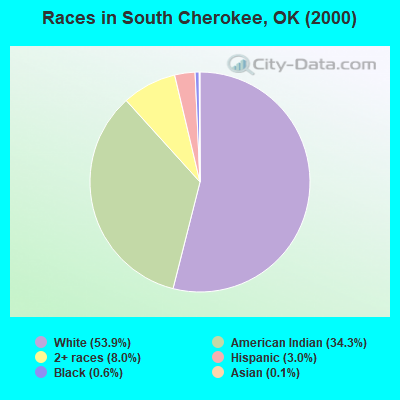
- 3,07253.9%White alone
- 1,95934.3%American Indian alone
- 4548.0%Two or more races
- 1723.0%Hispanic
- 340.6%Black alone
- 80.1%Asian alone
- 50.09%Other race alone
Races in South Cherokee detailed stats: ancestries, foreign born residents, place of birth
 Recent articles from our blog. Our writers, many of them Ph.D. graduates or candidates, create easy-to-read articles on a wide variety of topics.
Current Local Time: CST time zone
Land area: 137.0 square miles.
Population density: 44 people per square mile (very low).

| South Cherokee CCD: | 0.5% ($287) |
| Oklahoma: | 0.8% ($523) |
Nearest city with pop. 50,000+: Fort Smith, AR  (43.2 miles , pop. 80,268).
Nearest city with pop. 200,000+: Tulsa, OK (58.5 miles , pop. 393,049).
Nearest city with pop. 1,000,000+: Dallas, TX (228.2 miles , pop. 1,188,580).
Nearest cities:
), ), ), ), ), ), ), )Latitude: 35.75 N, Longitude: 95.00 W

| Here: | 3.4% |
| Oklahoma: | 3.2% |
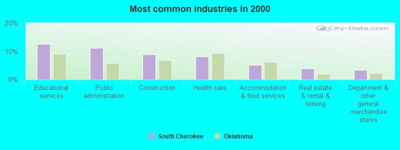
- Educational services (12.5%)
- Public administration (11.2%)
- Construction (8.8%)
- Health care (8.1%)
- Accommodation & food services (5.0%)
- Real estate & rental & leasing (3.9%)
- Department & other general merchandise stores (3.4%)
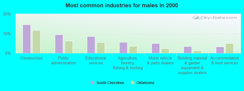
- Construction (14.7%)
- Public administration (9.5%)
- Educational services (8.6%)
- Agriculture, forestry, fishing & hunting (5.5%)
- Motor vehicle & parts dealers (4.9%)
- Building material & garden equipment & supplies dealers (3.4%)
- Accommodation & food services (3.3%)
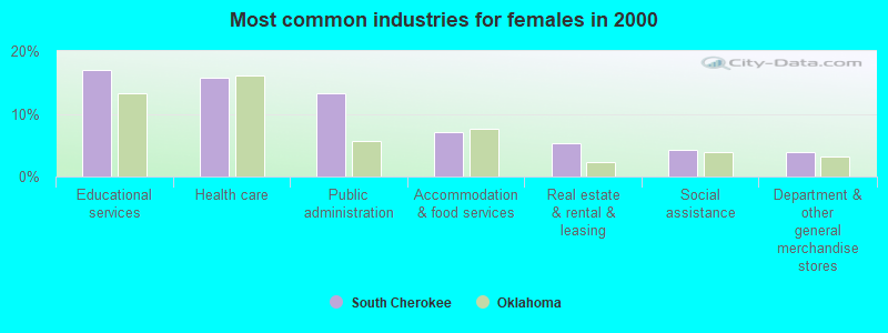
- Educational services (17.0%)
- Health care (15.7%)
- Public administration (13.2%)
- Accommodation & food services (7.1%)
- Real estate & rental & leasing (5.4%)
- Social assistance (4.3%)
- Department & other general merchandise stores (3.9%)
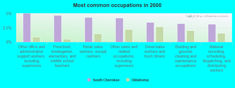
- Other office and administrative support workers, including supervisors (5.0%)
- Preschool, kindergarten, elementary, and middle school teachers (4.7%)
- Retail sales workers, except cashiers (4.3%)
- Other sales and related occupations, including supervisors (4.2%)
- Driver/sales workers and truck drivers (3.4%)
- Building and grounds cleaning and maintenance occupations (3.3%)
- Material recording, scheduling, dispatching, and distributing workers (3.2%)
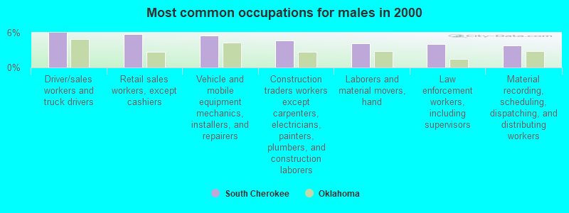
- Driver/sales workers and truck drivers (6.0%)
- Retail sales workers, except cashiers (5.7%)
- Vehicle and mobile equipment mechanics, installers, and repairers (5.5%)
- Construction traders workers except carpenters, electricians, painters, plumbers, and construction laborers (4.6%)
- Laborers and material movers, hand (4.2%)
- Law enforcement workers, including supervisors (4.1%)
- Material recording, scheduling, dispatching, and distributing workers (3.7%)
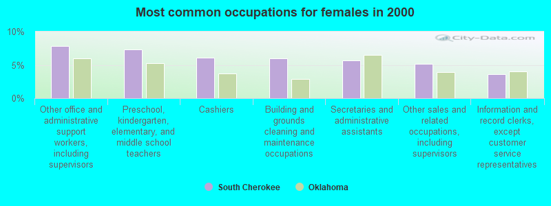
- Other office and administrative support workers, including supervisors (7.9%)
- Preschool, kindergarten, elementary, and middle school teachers (7.4%)
- Cashiers (6.1%)
- Building and grounds cleaning and maintenance occupations (6.0%)
- Secretaries and administrative assistants (5.7%)
- Other sales and related occupations, including supervisors (5.2%)
- Information and record clerks, except customer service representatives (3.6%)
Average climate in South Cherokee, Oklahoma
Based on data reported by over 4,000 weather stations


(lower is better)
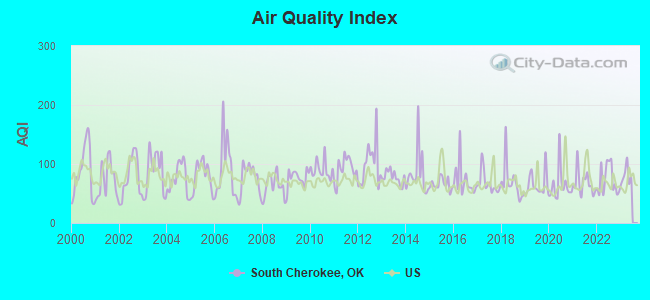
Air Quality Index (AQI) level in 2022 was 72.9. This is about average.
| City: | 72.9 |
| U.S.: | 72.6 |
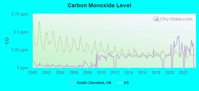
Carbon Monoxide (CO) [ppm] level in 2022 was 0.243. This is about average. Closest monitor was 7.2 miles away from the city center.
| City: | 0.243 |
| U.S.: | 0.251 |
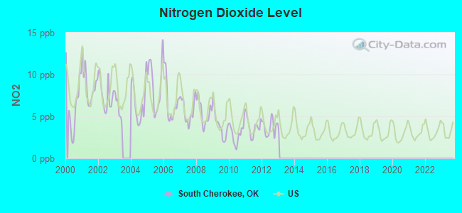
Nitrogen Dioxide (NO2) [ppb] level in 2012 was 3.69. This is better than average. Closest monitor was 7.2 miles away from the city center.
| City: | 3.69 |
| U.S.: | 5.11 |
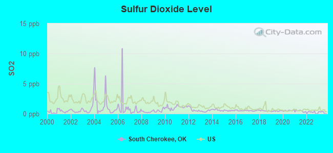
Sulfur Dioxide (SO2) [ppb] level in 2022 was 0.305. This is significantly better than average. Closest monitor was 7.2 miles away from the city center.
| City: | 0.305 |
| U.S.: | 1.515 |
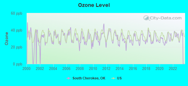
Ozone [ppb] level in 2022 was 33.0. This is about average. Closest monitor was 7.2 miles away from the city center.
| City: | 33.0 |
| U.S.: | 33.3 |
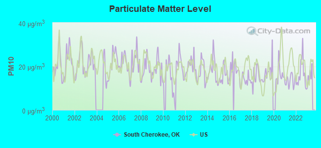
Particulate Matter (PM10) [µg/m3] level in 2022 was 16.4. This is about average. Closest monitor was 7.2 miles away from the city center.
| City: | 16.4 |
| U.S.: | 19.2 |
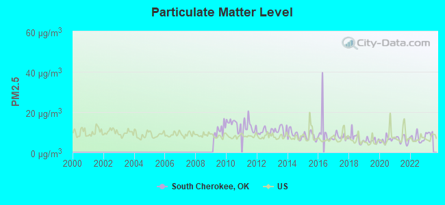
Particulate Matter (PM2.5) [µg/m3] level in 2022 was 6.76. This is about average. Closest monitor was 7.2 miles away from the city center.
| City: | 6.76 |
| U.S.: | 8.11 |
Tornado activity:
South Cherokee-area historical tornado activity is near Oklahoma state average. It is 134% greater than the overall U.S. average.
On 5/26/1973, a category F4 (max. wind speeds 207-260 mph) tornado 19.1 miles away from the South Cherokee place center killed 5 people and injured 25 people and caused between $50,000 and $500,000 in damages.
On 5/5/1960, a category F4 tornado 23.3 miles away from the place center killed 16 people and injured 106 people and caused between $500,000 and $5,000,000 in damages.
Earthquake activity:
South Cherokee-area historical earthquake activity is significantly above Oklahoma state average. It is 700% greater than the overall U.S. average.On 9/3/2016 at 12:02:44, a magnitude 5.8 (5.8 MW, Depth: 3.5 mi, Class: Moderate, Intensity: VI - VII) earthquake occurred 117.2 miles away from South Cherokee center
On 11/6/2011 at 03:53:10, a magnitude 5.7 (5.7 MW, Depth: 3.2 mi) earthquake occurred 100.1 miles away from South Cherokee center
On 11/7/2016 at 01:44:24, a magnitude 5.0 (5.0 MW, Depth: 2.8 mi) earthquake occurred 102.2 miles away from the city center
On 11/5/2011 at 07:12:45, a magnitude 4.8 (4.8 MW, Depth: 1.9 mi, Class: Light, Intensity: IV - V) earthquake occurred 99.9 miles away from the city center
On 11/8/2011 at 02:46:57, a magnitude 4.8 (4.8 MW, Depth: 3.1 mi) earthquake occurred 101.4 miles away from South Cherokee center
On 2/13/2016 at 17:07:06, a magnitude 5.1 (5.1 MW, Depth: 5.2 mi) earthquake occurred 213.2 miles away from the city center
Magnitude types: moment magnitude (MW)
Natural disasters:
The number of natural disasters in Cherokee County (23) is greater than the US average (15).Major Disasters (Presidential) Declared: 13
Emergencies Declared: 6
Causes of natural disasters: Floods: 11, Storms: 11, Winter Storms: 10, Tornadoes: 6, Winds: 3, Hurricane: 1, Snow: 1, Other: 1 (Note: some incidents may be assigned to more than one category).
Hospitals and medical centers near South Cherokee:
- AMEDISYS HOME HEALTH (Home Health Center, about 10 miles away; TAHLEQUAH, OK)
- CORNERSTONE HEALTH CARE, INC (Home Health Center, about 11 miles away; TAHLEQUAH, OK)
- DAVITA - TAHLEQUAH (Dialysis Facility, about 12 miles away; TAHLEQUAH, OK)
- W W HASTINGS INDIAN HOSPITAL Acute Care Hospitals (about 12 miles away; TAHLEQUAH, OK)
- CARTER HEALTHCARE AND HOSPICE (Hospital, about 12 miles away; TAHLEQUAH, OK)
- TRINITY HOSSPICE OF TAHLEQUAH (Hospital, about 12 miles away; TAHLEQUAH, OK)
- TAHLEQUAH CITY HOSPITAL Acute Care Hospitals (about 12 miles away; TAHLEQUAH, OK)
Colleges/universities with over 2000 students nearest to South Cherokee:
- Northeastern State University (about 12 miles; Tahlequah, OK; Full-time enrollment: 6,895)
- John Brown University (about 40 miles; Siloam Springs, AR; FT enrollment: 2,097)
- University of Arkansas-Fort Smith (about 44 miles; Fort Smith, AR; FT enrollment: 6,103)
- University of Arkansas (about 52 miles; Fayetteville, AR; FT enrollment: 22,163)
- Rogers State University (about 53 miles; Claremore, OK; FT enrollment: 3,482)
- Oklahoma State University Institute of Technology (about 54 miles; Okmulgee, OK; FT enrollment: 3,243)
- Carl Albert State College (about 54 miles; Poteau, OK; FT enrollment: 2,041)
Points of interest:
Notable locations in South Cherokee: Oklahoma Department of Agriculture Forestry Northeast Area (A), Woodall Fire Department Station 1 (B), Keys Fire Department Station 2 (C), Cherokee Nation Ambulance (D), Keys Fire Department Station 1 (E). Display/hide their locations on the map
Churches in South Cherokee include: Carter Church (A), Cherokee Home Mission (B), Keys Mission Church (C). Display/hide their locations on the map
Cemeteries: Park Hill Mission Cemetery (1), White Oak Cemetery (2), Pettit Cemetery (3), Lowrey Cemetery (4), Chambers Cemetery (5), Park Hill Cemetery (6), Philipps Cemetery (7). Display/hide their locations on the map
Reservoir: Oknoname 111088 Reservoir (A). Display/hide its location on the map
Streams, rivers, and creeks: White Oak Branch (A), Spaniard Creek (B), Sisemore Creek (C), Salt Branch (D), Gum Creek (E), Burnt Cabin Creek (F), Pettit Creek (G), Park Hill Branch (H), Goodman Branch (I). Display/hide their locations on the map
Parks in South Cherokee include: Tenkiller Wildlife Managment Area (1), Cookson Bluff Public Use Area (2), Burnt Cabin Ridge State Park (3), Strayhorn Landing Public Use Area (4), Sisemore Landing Public Use Area (5), Carters Landing Public Use Area (6), Pettit Bay Public Use Area (7), Murrell Home Park (8), Cherokee Landing State Park (9). Display/hide their locations on the map
| This place: | 2.6 people |
| Oklahoma: | 2.5 people |
| This place: | 75.0% |
| Whole state: | 66.8% |
| This place: | 5.9% |
| Whole state: | 5.9% |
Likely homosexual households (counted as self-reported same-sex unmarried-partner households)
- Lesbian couples: 0.3% of all households
- Gay men: 0.4% of all households
| This place: | 26.3% |
| Whole state: | 14.7% |
| This place: | 11.1% |
| Whole state: | 6.1% |
17 people in correctional facilities intended for juveniles in 2010
People in group quarters in South Cherokee in 2000:
- 209 people in job corps and vocational training facilities
- 17 people in unknown juvenile institutions
- 4 people in other noninstitutional group quarters
For population 15 years and over in South Cherokee:
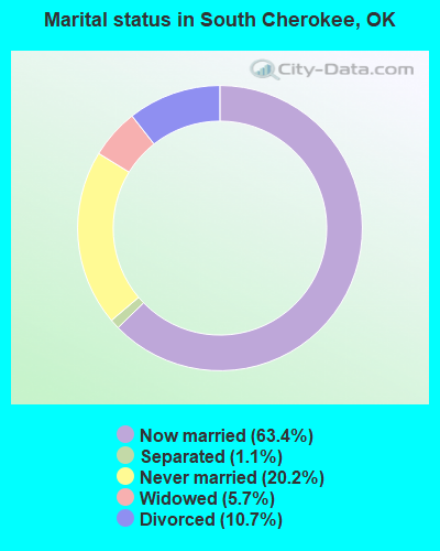
- Never married: 20.2%
- Now married: 63.4%
- Separated: 1.1%
- Widowed: 5.7%
- Divorced: 10.7%
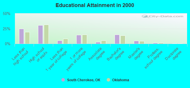
For population 25 years and over in South Cherokee:
- High school or higher: 75.2%
- Bachelor's degree or higher: 21.7%
- Graduate or professional degree: 6.7%
- Unemployed: 13.7%
- Mean travel time to work (commute): 23.3 minutes
| Here: | 12.7 |
| Oklahoma average: | 11.7 |
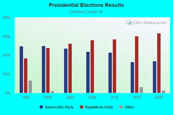


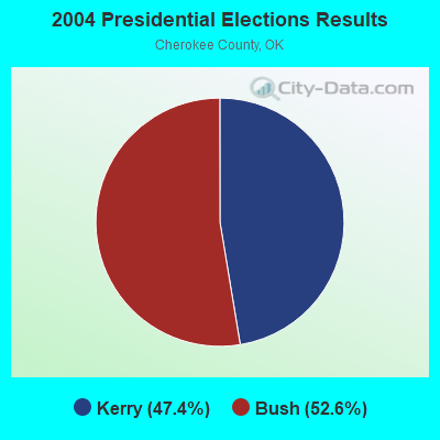
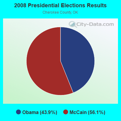
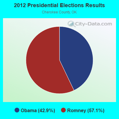
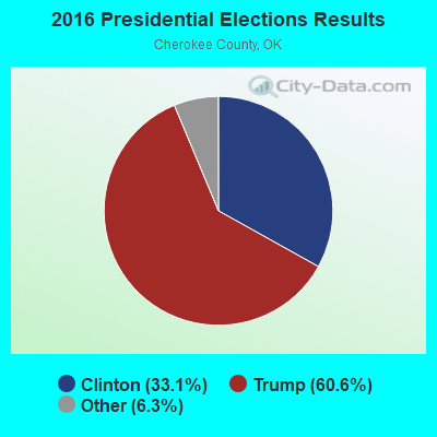
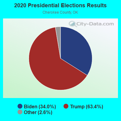
Graphs represent county-level data. Detailed 2008 Election Results
Religion statistics for South Cherokee, OK (based on Cherokee County data)
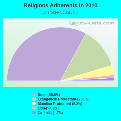
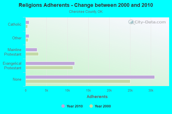
| Religion | Adherents | Congregations |
|---|---|---|
| Evangelical Protestant | 11,733 | 65 |
| Mainline Protestant | 2,717 | 12 |
| Other | 842 | 3 |
| Catholic | 800 | 2 |
| None | 30,895 | - |
Food Environment Statistics:
| Cherokee County: | 2.00 / 10,000 pop. |
| Oklahoma: | 1.97 / 10,000 pop. |
| Cherokee County: | 0.22 / 10,000 pop. |
| Oklahoma: | 0.20 / 10,000 pop. |
| Cherokee County: | 2.00 / 10,000 pop. |
| State: | 0.76 / 10,000 pop. |
| This county: | 4.66 / 10,000 pop. |
| Oklahoma: | 4.35 / 10,000 pop. |
| Cherokee County: | 6.21 / 10,000 pop. |
| State: | 6.89 / 10,000 pop. |
| This county: | 11.0% |
| Oklahoma: | 10.3% |
| Here: | 31.0% |
| Oklahoma: | 29.2% |
Strongest AM radio stations in South Cherokee:
- KFAQ (1170 AM; 50 kW; TULSA, OK; Owner: JOURNAL BROADCAST CORPORATION)
- KRMG (740 AM; 50 kW; TULSA, OK; Owner: CXR HOLDINGS, INC.)
- KTLQ (1350 AM; 1 kW; TAHLEQUAH, OK; Owner: JOHNSON COMMUNICATIONS, INC.)
- KTBZ (1430 AM; 25 kW; TULSA, OK; Owner: CLEAR CHANNEL BROADCASTING LICENSES, INC.)
- KYHN (1320 AM; 10 kW; FORT SMITH, AR; Owner: CAPSTAR TX LIMITED PARTNERSHIP)
- KFAY (1030 AM; 10 kW; FARMINGTON, AR; Owner: CUMULUS LICENSING CORP)
- KMUS (1380 AM; 20 kW; MUSKOGEE, OK; Owner: ABC, INC.)
- KXTD (1530 AM; daytime; 5 kW; WAGONER, OK; Owner: GAYTAN-GALVAN LIMITED LIABILITY COMP)
- KWHN (1650 AM; 10 kW; FT. SMITH, AR; Owner: CAPSTAR TX LIMITED PARTNERSHIP)
- KUOA (1290 AM; 5 kW; SILOAM SPRINGS, AR; Owner: KUOA, INC.)
- KGHT (880 AM; 50 kW; SHERIDAN, AR; Owner: METROPOLITAN RADIO GROUP, INC.)
- KOMA (1520 AM; 50 kW; OKLAHOMA CITY, OK; Owner: RENDA BROADCASTING CORP. OF NEVADA)
- KURM (790 AM; 5 kW; ROGERS, AR; Owner: KERM, INC)
Strongest FM radio stations in South Cherokee:
- KEOK (101.7 FM; TAHLEQUAH, OK; Owner: JOHNSON COMMUNICATIONS, INC.)
- KNYD (90.5 FM; BROKEN ARROW, OK; Owner: CREATIVE EDUCATIONAL MEDIA CORP. INC)
- KZBB (97.9 FM; POTEAU, OK; Owner: CAPSTAR TX LIMITED PARTNERSHIP)
- KMAG (99.1 FM; FORT SMITH, AR; Owner: CAPSTAR TX LIMITED PARTNERSHIP)
- KTCS-FM (99.9 FM; FORT SMITH, AR; Owner: BIG CHIEF BROADCASTING COMPANY)
- K204EW (88.7 FM; POTEAU, OK; Owner: CALVARY CHAPEL OF TWIN FALLS, INC.)
- K219CN (91.7 FM; POTEAU, OK; Owner: AMERICAN FAMILY ASSOCIATION)
- KARG (91.7 FM; POTEAU, OK; Owner: AMERICAN FAMILY ASSOCIATION)
- KISR (93.7 FM; FORT SMITH, AR; Owner: STEREO 93, INC.)
- KJSR (103.3 FM; TULSA, OK; Owner: CXR HOLDINGS, INC.)
- K204CA (88.7 FM; TAHLEQUAH, OK; Owner: THE MOODY BIBLE INSTITUTE OF CHICAGO)
- KMMY (97.1 FM; MUSKOGEE, OK; Owner: KMMY, Inc.)
- KMYZ-FM (104.5 FM; PRYOR, OK; Owner: SHAMROCK COMMUNICATIONS, INC.)
- KTKL (88.5 FM; STIGLER, OK; Owner: EDUCATIONAL MEDIA FOUNDATION)
- KREU (92.3 FM; ROLAND, OK; Owner: STAR 92 CO.)
- KWGS (89.5 FM; TULSA, OK; Owner: THE UNIVERSITY OF TULSA)
- KKBD (95.9 FM; SALLISAW, OK; Owner: CAPSTAR TX LIMITED PARTNERSHIP)
- KDAB (94.9 FM; PRAIRIE GROVE, AR; Owner: CUMULUS LICENSING CORP.)
- KHTT (106.9 FM; MUSKOGEE, OK; Owner: RENDA BROADCASTING CORP. OF NEVADA)
- KCXR (100.3 FM; TAFT, OK; Owner: KXOJ INC.)
TV broadcast stations around South Cherokee:
- KTUL (Channel 8; TULSA, OK; Owner: KTUL, LLC)
- KJRH (Channel 2; TULSA, OK; Owner: SCRIPPS HOWARD BROADCASTING COMPANY)
- KOED-TV (Channel 11; TULSA, OK; Owner: OKLAHOMA EDUCATIONAL TELEVISION AUTHORITY)
- KOTV (Channel 6; TULSA, OK; Owner: GRIFFIN LICENSING, L.L.C.)
- KFSM-TV (Channel 5; FORT SMITH, AR; Owner: NEW YORK TIMES MANAGEMENT SERVICES)
- KTFO (Channel 41; TULSA, OK; Owner: CLEAR CHANNEL BROADCASTING LICENSES, INC.)
- KWHB (Channel 47; TULSA, OK; Owner: LESEA BROADCASTING CORPORATION)
- K31DY (Channel 31; MUSKOGEE, OK; Owner: LOCKE SUPPLY CO.)
- K48FL (Channel 48; FORT SMITH, AR; Owner: TV 34, INC.)
- KOKI-TV (Channel 23; TULSA, OK; Owner: CLEAR CHANNEL BROADCASTING LICENSES, INC.)
- K25GJ (Channel 25; MUSKOGEE, OK; Owner: TRINITY BROADCASTING NETWORK)
- K52GX (Channel 52; TAHLEQUAH, OK; Owner: TRINITY BROADCASTING NETWORK)
- K04DY (Channel 4; TAHLEQUAH, OK; Owner: NORTHEASTERN STATE UNIVERSITY)
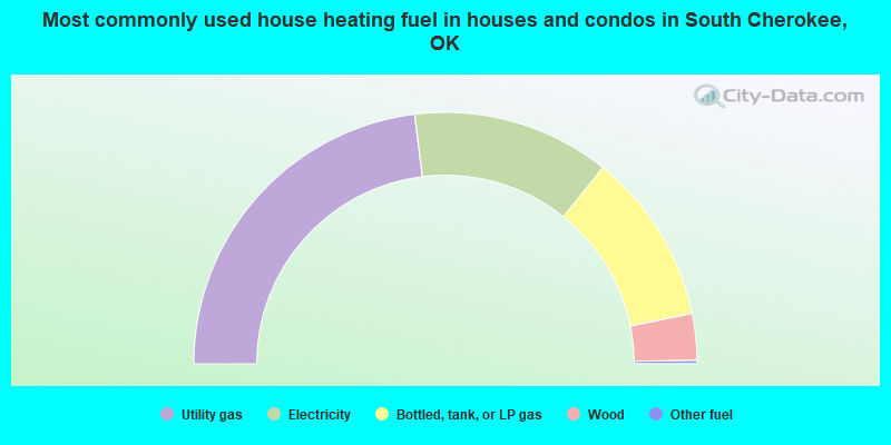
- 46.1%Utility gas
- 25.4%Electricity
- 22.1%Bottled, tank, or LP gas
- 6.0%Wood
- 0.4%Other fuel
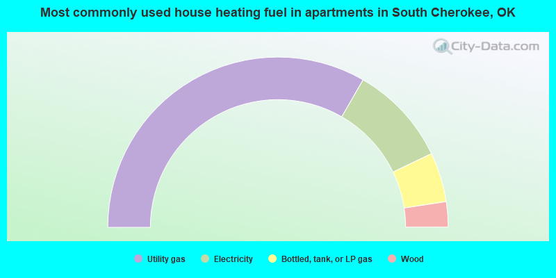
- 66.6%Utility gas
- 19.1%Electricity
- 9.4%Bottled, tank, or LP gas
- 4.8%Wood
South Cherokee compared to Oklahoma state average:
- Black race population percentage significantly below state average.
- Hispanic race population percentage significantly below state average.
- Foreign-born population percentage significantly below state average.
- Length of stay since moving in significantly above state average.
- Number of rooms per house significantly below state average.
- House age significantly below state average.
South Cherokee on our top lists:
- #11 on the list of "Top 101 cities with largest percentage of males in occupations: other teachers and instructors, education, training, and library occupations (population 5,000+)"
- #15 on the list of "Top 101 cities with largest percentage of males in occupations: retail sales workers except cashiers (population 5,000+)"
- #17 on the list of "Top 101 cities with largest percentage of males in industries: miscellaneous durable goods merchant wholesalers (population 5,000+)"
- #23 on the list of "Top 101 cities with the largest percentage of people in job corps and vocational training facilities (population 1,000+)"
- #25 on the list of "Top 101 cities with largest percentage of males in industries: motor vehicle and parts dealers (population 5,000+)"
- #26 on the list of "Top 101 cities with largest percentage of males in industries: building material and garden equipment and supplies dealers (population 5,000+)"
- #28 on the list of "Top 101 cities with largest percentage of males in industries: u. s. postal service (population 5,000+)"
- #32 on the list of "Top 101 cities with largest percentage of males in industries: miscellaneous nondurable goods merchant wholesalers (population 5,000+)"
- #38 on the list of "Top 101 cities with largest percentage of males in industries: department and other general merchandise stores (population 5,000+)"
- #38 on the list of "Top 101 cities with largest percentage of males in industries: social assistance (population 5,000+)"
- #48 on the list of "Top 101 cities with largest percentage of males in occupations: extraction workers (population 5,000+)"
- #50 on the list of "Top 101 cities with largest percentage of males in industries: lumber and other construction materials merchant wholesalers (population 5,000+)"
- #51 on the list of "Top 101 cities with largest percentage of females in occupations: other transportation workers (population 5,000+)"
- #65 on the list of "Top 101 cities with largest percentage of males in occupations: life and physical scientists (population 5,000+)"
- #66 on the list of "Top 101 cities with largest percentage of males in occupations: preschool, kindergarten, elementary and middle school teachers (population 5,000+)"
- #20 on the list of "Top 101 counties with the worst general health status score of residents (1-5), 3 years of data"
- #47 on the list of "Top 101 counties with the lowest percentage of residents that exercised in the past month"
- #56 on the list of "Top 101 counties with the lowest ground withdrawal of fresh water for public supply"
- #80 on the list of "Top 101 counties with the highest percentage of residents that drank alcohol in the past 30 days"
- #100 on the list of "Top 101 counties with the highest percentage of residents that smoked 100+ cigarettes in their lives"