South Fork, Montana
Submit your own pictures of this place and show them to the world
- OSM Map
- General Map
- Google Map
- MSN Map

| Males: 1,448 | |
| Females: 1,361 |
| Median resident age: | 39.6 years |
| Montana median age: | 37.5 years |
Zip code: 59919
| South Fork: | $51,954 |
| MT: | $67,631 |
Estimated per capita income in 2022: $31,111 (it was $15,540 in 2000)
South Fork CCD income, earnings, and wages data
Estimated median house or condo value in 2022: $389,118 (it was $85,700 in 2000)
| South Fork: | $389,118 |
| MT: | $366,400 |
Mean prices in 2022: all housing units: $609,615; detached houses: $672,934; townhouses or other attached units: $524,287; in 2-unit structures: $378,963; in 3-to-4-unit structures: $406,851; in 5-or-more-unit structures: $506,066; mobile homes: $126,032; occupied boats, rvs, vans, etc.: $117,959
Detailed information about poverty and poor residents in South Fork, MT


- 2,25393.6%White alone
- 672.8%American Indian alone
- 472.0%Two or more races
- 341.4%Hispanic
- 50.2%Asian alone
- 10.04%Other race alone

Races in South Fork detailed stats: ancestries, foreign born residents, place of birth
 Recent articles from our blog. Our writers, many of them Ph.D. graduates or candidates, create easy-to-read articles on a wide variety of topics.
Current Local Time: MST time zone
Land area: 1728.3 square miles.
Population density: 1.6 people per square mile (very low).

| South Fork CCD: | 1.1% ($903) |
| Montana: | 1.3% ($1,212) |
Nearest city with pop. 50,000+: Missoula, MT  (97.4 miles , pop. 57,053).
Nearest city with pop. 200,000+: East Seattle, WA (389.0 miles , pop. 480,100).
Nearest city with pop. 1,000,000+: Los Angeles, CA (1008.5 miles , pop. 3,694,820).
Nearest cities:
), ), ), Latitude: 48.27 N, Longitude: 113.82 W
Area code commonly used in this area: 406


South Fork tourist attractions:
| Here: | 4.7% |
| Montana: | 3.8% |

- Accommodation & food services (15.0%)
- Construction (11.9%)
- Wood products (9.1%)
- Health care (6.9%)
- Administrative & support & waste management services (5.6%)
- Educational services (4.0%)
- Furniture & related product manufacturing (3.8%)

- Construction (19.6%)
- Wood products (14.3%)
- Accommodation & food services (9.5%)
- Furniture & related product manufacturing (5.7%)
- Administrative & support & waste management services (5.3%)
- Agriculture, forestry, fishing & hunting (5.1%)
- Building material & garden equipment & supplies dealers (5.1%)

- Accommodation & food services (22.4%)
- Health care (15.7%)
- Food & beverage stores (7.0%)
- Educational services (6.5%)
- Administrative & support & waste management services (6.0%)
- Professional, scientific, technical services (4.5%)
- Social assistance (4.0%)

- Driver/sales workers and truck drivers (6.2%)
- Woodworkers (5.6%)
- Building and grounds cleaning and maintenance occupations (5.6%)
- Electrical equipment mechanics and other installation, maintenance, and repair workers, including supervisors (4.9%)
- Other management occupations, except farmers and farm managers (4.6%)
- Laborers and material movers, hand (4.0%)
- Other production occupations, including supervisors (4.0%)

- Driver/sales workers and truck drivers (10.1%)
- Woodworkers (9.7%)
- Electrical equipment mechanics and other installation, maintenance, and repair workers, including supervisors (8.4%)
- Other production occupations, including supervisors (7.0%)
- Laborers and material movers, hand (6.2%)
- Construction traders workers except carpenters, electricians, painters, plumbers, and construction laborers (6.2%)
- Carpenters (4.8%)

- Building and grounds cleaning and maintenance occupations (10.9%)
- Bookkeeping, accounting, and auditing clerks (6.5%)
- Nursing, psychiatric, and home health aides (6.0%)
- Secretaries and administrative assistants (6.0%)
- Other management occupations, except farmers and farm managers (5.5%)
- Cashiers (4.7%)
- Other office and administrative support workers, including supervisors (4.7%)
Average climate in South Fork, Montana
Based on data reported by over 4,000 weather stations


(lower is better)

Air Quality Index (AQI) level in 2023 was 77.8. This is about average.
| City: | 77.8 |
| U.S.: | 72.6 |

Carbon Monoxide (CO) [ppm] level in 2005 was 0.323. This is worse than average. Closest monitor was 21.4 miles away from the city center.
| City: | 0.323 |
| U.S.: | 0.251 |

Ozone [ppb] level in 2023 was 29.7. This is about average. Closest monitor was 18.7 miles away from the city center.
| City: | 29.7 |
| U.S.: | 33.3 |

Particulate Matter (PM10) [µg/m3] level in 2022 was 17.3. This is about average. Closest monitor was 17.0 miles away from the city center.
| City: | 17.3 |
| U.S.: | 19.2 |

Particulate Matter (PM2.5) [µg/m3] level in 2022 was 8.52. This is about average. Closest monitor was 18.1 miles away from the city center.
| City: | 8.52 |
| U.S.: | 8.11 |
Earthquake activity:
South Fork-area historical earthquake activity is significantly above Montana state average. It is 700% greater than the overall U.S. average.On 8/18/1959 at 06:37:13, a magnitude 7.7 (7.7 UK, Class: Major, Intensity: VIII - XII) earthquake occurred 297.1 miles away from South Fork center, causing $26,000,000 total damage
On 10/28/1983 at 14:06:06, a magnitude 7.3 (6.2 MB, 7.3 MS, 7.0 MW) earthquake occurred 289.7 miles away from the city center, causing 2 deaths (2 shaking deaths) and 3 injuries, causing $15,000,000 total damage
On 7/6/2017 at 06:30:17, a magnitude 5.8 (5.8 MW, Depth: 7.6 mi, Class: Moderate, Intensity: VI - VII) earthquake occurred 112.0 miles away from South Fork center
On 3/31/2020 at 23:52:30, a magnitude 6.5 (6.5 MW, Depth: 7.5 mi, Class: Strong, Intensity: VII - IX) earthquake occurred 270.0 miles away from the city center
On 4/13/1949 at 19:55:42, a magnitude 7.0 (7.0 UK) earthquake occurred 409.3 miles away from the city center, causing $80,000,000 total damage
On 2/28/2001 at 18:54:32, a magnitude 6.8 (6.5 MB, 6.6 MS, 6.8 MW) earthquake occurred 415.6 miles away from South Fork center, causing $2,000,000,000 total damage and $305,000,000 insured losses
Magnitude types: body-wave magnitude (MB), surface-wave magnitude (MS), moment magnitude (MW)
Natural disasters:
The number of natural disasters in Flathead County (12) is smaller than the US average (15).Major Disasters (Presidential) Declared: 6
Emergencies Declared: 1
Causes of natural disasters: Fires: 5, Floods: 5, Storms: 4, Snows: 2, Hurricane: 1, Landslide: 1, Other: 1 (Note: some incidents may be assigned to more than one category).
Colleges/universities with over 2000 students nearest to South Fork:
- The University of Montana (about 98 miles; Missoula, MT; Full-time enrollment: 13,602)
- North Idaho College (about 144 miles; Coeur d'Alene, ID; FT enrollment: 4,684)
- Spokane Community College (about 169 miles; Spokane, WA; FT enrollment: 6,482)
- Whitworth University (about 171 miles; Spokane, WA; FT enrollment: 2,689)
- Gonzaga University (about 171 miles; Spokane, WA; FT enrollment: 6,780)
- Spokane Falls Community College (about 174 miles; Spokane, WA; FT enrollment: 6,052)
- Eastern Washington University (about 183 miles; Cheney, WA; FT enrollment: 11,643)
Points of interest:
Notable locations in South Fork: Coram RV Park (A), North American RV Park and Campground (B), Half-Way Motel Campground (C), Stanton Creek Lodge Campground (D), Crooked Tree Motel and RV Park (E), Canyon RV and Campground (F), Duval RV and Bike Park (G), Mountain Meadow RV Park and Campground (H), Middle Fork Motel and RV Park (I), Sundance RV Campground (J), Strawberry Lake Forest Service Station (K), Black Bear Forest Service (L), Riverside Boat Landing (M), Grizzly (N), Lost Johnny Boat Landing (O), Red Eagle (P), Java (Q), Meadow Creek Recreaton Site (R), Quintokon Forest Service Station (S), Peters Creek Sportsmans Access (T). Display/hide their locations on the map
Churches in South Fork include: Lion Hill Baptist Church (A), Hungry Horse Baptist Church (B), Hungry Horse Chapel (C), Canyon Community Church (D). Display/hide their locations on the map
Cemetery: Baptiste Graye (1). Display/hide its location on the map
Lakes, reservoirs, and swamps: Blackfoot Lake (A), Black Lake (B), Almeda Lake (C), Olor Lake (D), Alpha Lake (E), Birch Lake (F), Margaret Lake (G), Diamond Lake (H). Display/hide their locations on the map
Rivers and creeks: Deerlick Creek (A), Flat Creek (B), Abbot Creek (C), Ada Creek (D), Addition Creek (E), Aeneas Creek (F), Alcove Creek (G), Alice Creek (H), Alora Creek (I). Display/hide their locations on the map
Park in South Fork: Coram Experimental Forest (1). Display/hide its location on the map
| This place: | 2.2 people |
| Montana: | 2.4 people |
| This place: | 60.8% |
| Whole state: | 62.8% |
| This place: | 7.2% |
| Whole state: | 6.7% |
Likely homosexual households (counted as self-reported same-sex unmarried-partner households)
- Lesbian couples: 0.7% of all households
- Gay men: 0.5% of all households
| This place: | 22.6% |
| Whole state: | 14.6% |
| This place: | 8.4% |
| Whole state: | 5.8% |
For population 15 years and over in South Fork:

- Never married: 19.7%
- Now married: 59.9%
- Separated: 1.8%
- Widowed: 4.5%
- Divorced: 15.9%
For population 25 years and over in South Fork:
- High school or higher: 84.1%
- Bachelor's degree or higher: 9.8%
- Graduate or professional degree: 2.4%
- Unemployed: 13.8%
- Mean travel time to work (commute): 24.9 minutes


| Here: | 8.7 |
| Montana average: | 10.4 |
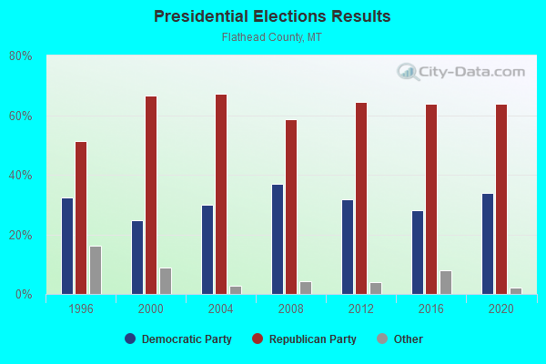
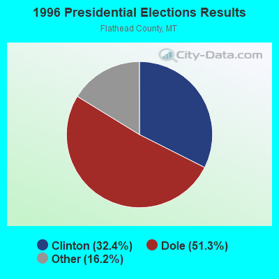

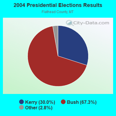

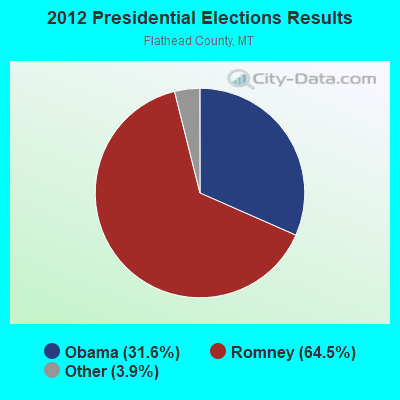
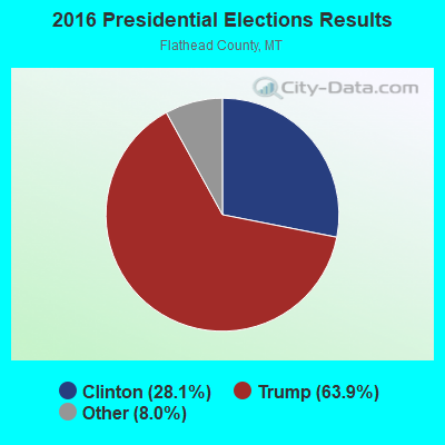

Graphs represent county-level data. Detailed 2008 Election Results
Religion statistics for South Fork, MT (based on Flathead County data)
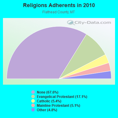
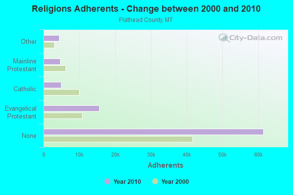
| Religion | Adherents | Congregations |
|---|---|---|
| Evangelical Protestant | 15,544 | 83 |
| Catholic | 4,933 | 6 |
| Mainline Protestant | 4,594 | 17 |
| Other | 4,370 | 20 |
| Black Protestant | 15 | 1 |
| None | 61,472 | - |
Food Environment Statistics:
| Flathead County: | 1.73 / 10,000 pop. |
| State: | 2.55 / 10,000 pop. |
| Flathead County: | 0.12 / 10,000 pop. |
| Montana: | 0.20 / 10,000 pop. |
| Flathead County: | 0.23 / 10,000 pop. |
| State: | 0.48 / 10,000 pop. |
| This county: | 5.19 / 10,000 pop. |
| Montana: | 4.69 / 10,000 pop. |
| This county: | 11.18 / 10,000 pop. |
| State: | 10.38 / 10,000 pop. |
| This county: | 5.8% |
| Montana: | 7.2% |
| Here: | 20.0% |
| Montana: | 23.1% |
| Flathead County: | 8.4% |
| Montana: | 10.7% |
Strongest AM radio stations in South Fork:
- KOFI (1180 AM; 50 kW; KALISPELL, MT; Owner: KOFI, INC.)
- KERR (750 AM; 50 kW; POLSON, MT; Owner: ANDERSON RADIO BROADCASTING, INC.)
- KJJR (880 AM; 10 kW; WHITEFISH, MT; Owner: BEE BROADCASTING, INCORPORATED)
- KGEZ (600 AM; 5 kW; KALISPELL, MT; Owner: SKYLINE BROADCASTERS, INC.)
- KGA (1510 AM; 50 kW; SPOKANE, WA; Owner: CITADEL BROADCASTING COMPANY)
- KSEN (1150 AM; 10 kW; SHELBY, MT; Owner: CAPSTAR TX LIMITED PARTNERSHIP)
- KTBI (810 AM; daytime; 50 kW; EPHRATA, WA; Owner: TACOMA BROADCASTERS, INCORPORATED)
- KXLY (920 AM; 20 kW; SPOKANE, WA; Owner: SPOKANE RADIO, INC.)
- KQQQ (1150 AM; 25 kW; PULLMAN, WA; Owner: RADIO PALOUSE, INC.)
- KBOI (670 AM; 50 kW; BOISE, ID; Owner: CITADEL BROADCASTING COMPANY)
- KLCY (930 AM; 5 kW; EAST MISSOULA, MT; Owner: CAPSTAR TX LIMITED PARTNERSHIP)
- KMON (560 AM; 5 kW; GREAT FALLS, MT; Owner: COMMONWEALTH LICENSE SUBSIDIARY, LLC)
- KMJY (700 AM; 10 kW; NEWPORT, WA; Owner: JAMES E. AND HELEN G. STARGEL)
Strongest FM radio stations in South Fork:
- KDBR (106.3 FM; KALISPELL, MT; Owner: BEE BROADCASTING, INC.)
- KKMT (95.9 FM; COLUMBIA FALLS, MT; Owner: BEE BROADCASTING, INC.)
- KALS (97.1 FM; KALISPELL, MT; Owner: KALISPELL CHRISTIAN RADIO FELLOWSHIP, INC.)
- KBBZ (98.5 FM; KALISPELL, MT; Owner: BEE BROADCASTING, INC.)
- KSIL (100.7 FM; WALLACE, ID; Owner: ANDERSON RADIO BROADCASTING, INC.)
- KQRK (92.3 FM; RONAN, MT; Owner: ANDERSON RADIO BROADCASTING, INC.)
- KPLG (91.5 FM; PLAINS, MT; Owner: YOUR NETWORK OF PRAISE, INC.)
- KZMN (103.9 FM; KALISPELL, MT; Owner: KOFI, INC.)
- KUKL (89.9 FM; KALISPELL, MT; Owner: THE UNIVERSITY OF MONTANA)
- K204CJ (88.7 FM; KALISPELL, MT; Owner: YOUR CHRISTIAN COMPANION NETWORK, INC.)
- K208DI (89.5 FM; KALISPELL, MT; Owner: EDUCATIONAL MEDIA FOUNDATION)
- K259AD (99.7 FM; KALISPELL, MT; Owner: BEE B/C INC.)
TV broadcast stations around South Fork:
- K05EE (Channel 5; BIG ARM, ETC., MT; Owner: BLACKTAIL TV TAX DISTRICT)
- K59BW (Channel 59; BONNERS FERRY, ID; Owner: STATE BOARD OF EDUCATION (IEPBS))

- 52.9%Utility gas
- 18.9%Electricity
- 15.2%Wood
- 11.6%Bottled, tank, or LP gas
- 1.1%No fuel used
- 0.3%Other fuel

- 64.2%Utility gas
- 18.8%Wood
- 10.9%Electricity
- 3.5%Bottled, tank, or LP gas
- 2.6%Other fuel
South Fork compared to Montana state average:
- Black race population percentage significantly below state average.
- Hispanic race population percentage significantly below state average.
- Foreign-born population percentage significantly below state average.
- Length of stay since moving in significantly above state average.
- Number of rooms per house significantly below state average.
- House age significantly below state average.
- Number of college students below state average.
- Percentage of population with a bachelor's degree or higher significantly below state average.
South Fork on our top lists:
- #65 on the list of "Top 100 cities with largest land areas"
- #33 on the list of "Top 101 counties with the highest percentage of residents that drank alcohol in the past 30 days"
- #41 on the list of "Top 101 counties with the lowest average weight of females"
- #45 on the list of "Top 101 counties with highest percentage of residents voting for 3rd party candidates in the 2012 Presidential Election (pop. 50,000+)"
- #47 on the list of "Top 101 counties with the lowest percentage of residents that visited a dentist within the past year"
- #64 on the list of "Top 101 counties with the lowest Ozone (1-hour) air pollution readings in 2012 (ppm)"