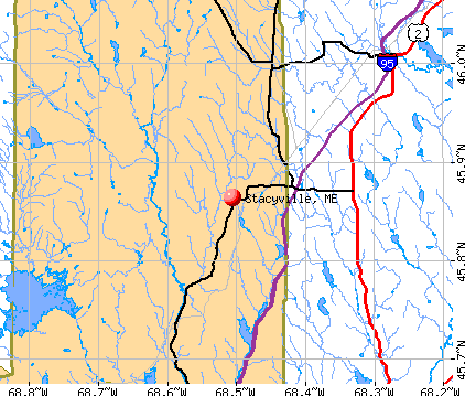
Stacyville, Maine

Stacyville: Trail riding at Sunset Stacyville Maine

Stacyville: Mountain view

Stacyville: Hiking with Moose
- add
your
Submit your own pictures of this town and show them to the world
- OSM Map
- General Map
- Google Map
- MSN Map
Population change since 2000: -2.2%
 |
| Males: 217 | |
| Females: 179 |
| Median resident age: | 42.0 years |
| Maine median age: | 43.0 years |
Zip codes: 04777.
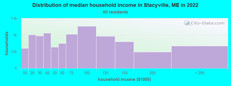
| Stacyville: | $47,566 |
| ME: | $69,543 |
Estimated per capita income in 2022: $24,025 (it was $11,951 in 2000)
Stacyville town income, earnings, and wages data
Estimated median house or condo value in 2022: $126,460 (it was $48,600 in 2000)
| Stacyville: | $126,460 |
| ME: | $290,600 |
Mean prices in 2022: all housing units: $235,563; detached houses: $252,705; townhouses or other attached units: $267,749; in 2-unit structures: $255,332; in 3-to-4-unit structures: $815,300; in 5-or-more-unit structures: $185,873; mobile homes: $93,017; occupied boats, rvs, vans, etc.: $21,333
Detailed information about poverty and poor residents in Stacyville, ME


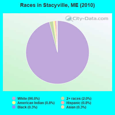
- 38096.0%White alone
- 82.0%Two or more races
- 30.8%American Indian alone
- 30.8%Hispanic
- 10.3%Black alone
- 10.3%Asian alone
Races in Stacyville detailed stats: ancestries, foreign born residents, place of birth
 Recent articles from our blog. Our writers, many of them Ph.D. graduates or candidates, create easy-to-read articles on a wide variety of topics.

 | Are there really people who never ventured out of state? (42 replies) |
| Vote NO on Federal Park (94 replies) |
| MOre Windmills!!! (18 replies) |
| Furnace question, new home. (81 replies) |
| Leasing land for a camp - Stacyville (0 replies) |
| Home for sale in Corinth (46 replies) |
Latest news from Stacyville, ME collected exclusively by city-data.com from local newspapers, TV, and radio stations
Ancestries: Irish (31.1%), French (19.5%), English (15.8%), United States (13.8%), German (4.9%), Swedish (3.2%).
Current Local Time: EST time zone
Elevation: 569 feet
Land area: 39.9 square miles.
Population density: 9.9 people per square mile (very low).
16 residents are foreign born (3.5% North America, 0.5% Europe).
| This town: | 4.0% |
| Maine: | 2.9% |
| Stacyville town: | 1.1% ($536) |
| Maine: | 1.5% ($1,417) |
Nearest city with pop. 50,000+: Portland, ME  (178.1 miles , pop. 64,249).
Nearest city with pop. 200,000+: Boston, MA (279.7 miles , pop. 589,141).
Nearest city with pop. 1,000,000+: Bronx, NY (442.6 miles , pop. 1,332,650).
Nearest cities:
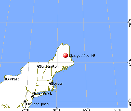
), )Latitude: 45.90 N, Longitude: 68.47 W
Area code commonly used in this area: 207

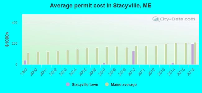
Single-family new house construction building permits:
- 2016: 1 building, cost: $200,000
- 2014: 4 buildings, average cost: $17,800
- 2010: 1 building, cost: $129,000
- 2007: 1 building, cost: $16,000
- 1999: 1 building, cost: $40,000

| Here: | 3.9% |
| Maine: | 3.4% |


- Agriculture, forestry, fishing & hunting (14.6%)
- Food & beverage stores (10.2%)
- Educational services (10.2%)
- Truck transportation (9.5%)
- Wood products (8.8%)
- Health care (8.0%)
- Paper (7.3%)

- Agriculture, forestry, fishing & hunting (23.1%)
- Truck transportation (16.7%)
- Paper (12.8%)
- Educational services (9.0%)
- Wood products (7.7%)
- Food & beverage stores (7.7%)
- Construction (6.4%)

- Health care (18.6%)
- Food & beverage stores (13.6%)
- Educational services (11.9%)
- Wood products (10.2%)
- Finance & insurance (10.2%)
- Accommodation & food services (8.5%)
- Public administration (5.1%)
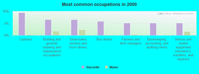
- Cashiers (9.5%)
- Building and grounds cleaning and maintenance occupations (6.6%)
- Driver/sales workers and truck drivers (6.6%)
- Bus drivers (5.8%)
- Farmers and farm managers (5.1%)
- Bookkeeping, accounting, and auditing clerks (5.1%)
- Vehicle and mobile equipment mechanics, installers, and repairers (5.1%)

- Driver/sales workers and truck drivers (11.5%)
- Bus drivers (10.3%)
- Building and grounds cleaning and maintenance occupations (9.0%)
- Farmers and farm managers (9.0%)
- Vehicle and mobile equipment mechanics, installers, and repairers (9.0%)
- Fishing, hunting, and forestry occupations (7.7%)
- Electricians (5.1%)

- Cashiers (16.9%)
- Bookkeeping, accounting, and auditing clerks (11.9%)
- Registered nurses (10.2%)
- Secretaries and administrative assistants (10.2%)
- Cooks and food preparation workers (8.5%)
- Health technologists and technicians (8.5%)
- Financial clerks, except bookkeeping, accounting and auditing clerks (6.8%)
Average climate in Stacyville, Maine
Based on data reported by over 4,000 weather stations


Earthquake activity:
Stacyville-area historical earthquake activity is significantly above Maine state average. It is 84% smaller than the overall U.S. average.On 4/20/2002 at 10:50:47, a magnitude 5.3 (5.3 ML, Depth: 3.0 mi, Class: Moderate, Intensity: VI - VII) earthquake occurred 272.3 miles away from the city center
On 4/20/2002 at 10:50:47, a magnitude 5.2 (5.2 MB, 4.2 MS, 5.2 MW, 5.0 MW) earthquake occurred 273.9 miles away from Stacyville center
On 10/16/2012 at 23:12:25, a magnitude 4.7 (4.7 ML, Depth: 10.0 mi, Class: Light, Intensity: IV - V) earthquake occurred 192.2 miles away from Stacyville center
On 10/7/1983 at 10:18:46, a magnitude 5.3 (5.1 MB, 5.3 LG, 5.1 ML) earthquake occurred 317.6 miles away from the city center
On 7/14/2006 at 09:34:48, a magnitude 3.9 (3.9 MD, Depth: 8.6 mi, Class: Light, Intensity: II - III) earthquake occurred 68.3 miles away from Stacyville center
On 1/19/1982 at 00:14:42, a magnitude 4.7 (4.5 MB, 4.7 MD, 4.5 LG) earthquake occurred 226.4 miles away from Stacyville center
Magnitude types: regional Lg-wave magnitude (LG), body-wave magnitude (MB), duration magnitude (MD), local magnitude (ML), surface-wave magnitude (MS), moment magnitude (MW)
Natural disasters:
The number of natural disasters in Penobscot County (19) is greater than the US average (15).Major Disasters (Presidential) Declared: 11
Emergencies Declared: 7
Causes of natural disasters: Floods: 9, Storms: 8, Snows: 5, Heavy Rains: 2, Blizzard: 1, Hurricane: 1, Ice Storm: 1, Snowfall: 1, Wind: 1, Winter Storm: 1, Other: 2 (Note: some incidents may be assigned to more than one category).
Colleges/universities with over 2000 students nearest to Stacyville:
- University of Maine (about 71 miles; Orono, ME; Full-time enrollment: 8,931)
- Husson University (about 76 miles; Bangor, ME; FT enrollment: 2,421)
- University of Maine at Farmington (about 119 miles; Farmington, ME; FT enrollment: 2,036)
- University of Maine at Augusta (about 127 miles; Augusta, ME; FT enrollment: 3,204)
- Saint Joseph's College of Maine (about 175 miles; Standish, ME; FT enrollment: 2,010)
- Southern Maine Community College (about 179 miles; South Portland, ME; FT enrollment: 4,666)
- University of Southern Maine (about 179 miles; Portland, ME; FT enrollment: 6,647)
Public high school in Stacyville:
Public elementary/middle school in Stacyville:
- KATAHDIN ELEMENTARY SCHOOL (Location: 805 STATION ROAD, Grades: PK-6)
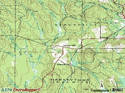
Points of interest:
Notable location: Stacyville Volunteer Fire Department (A). Display/hide its location on the map
Swamps: Kelly Bog (A). Display/hide its location on the map
Streams, rivers, and creeks: Torrie Brook (A), West Branch Mud Brook (B), West Branch Swift Brook (C), Sandy Brook (D), East Branch Swift Brook (E), Middle Branch Swift Brook (F), East Branch Mud Brook (G), Bog Brook (H). Display/hide their locations on the map
| This town: | 2.4 people |
| Maine: | 2.3 people |
| This town: | 66.0% |
| Whole state: | 62.9% |
| This town: | 8.6% |
| Whole state: | 9.4% |
No gay or lesbian households reported
| This town: | 17.7% |
| Whole state: | 10.9% |
| This town: | 8.3% |
| Whole state: | 4.1% |
For population 15 years and over in Stacyville:

- Never married: 11.7%
- Now married: 71.9%
- Separated: 1.3%
- Widowed: 6.7%
- Divorced: 8.4%
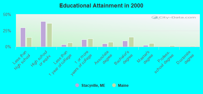
For population 25 years and over in Stacyville:
- High school or higher: 70.4%
- Bachelor's degree or higher: 11.6%
- Graduate or professional degree: 2.2%
- Unemployed: 13.3%
- Mean travel time to work (commute): 21.5 minutes

| Here: | 11.4 |
| Maine average: | 11.2 |


Graphs represent county-level data. Detailed 2008 Election Results
Religion statistics for Stacyville, ME (based on Penobscot County data)


| Religion | Adherents | Congregations |
|---|---|---|
| Catholic | 16,581 | 15 |
| Mainline Protestant | 9,715 | 59 |
| Evangelical Protestant | 7,523 | 80 |
| Other | 2,936 | 22 |
| Orthodox | 300 | 1 |
| None | 116,868 | - |
Food Environment Statistics:
| This county: | 2.29 / 10,000 pop. |
| State: | 2.80 / 10,000 pop. |
| Penobscot County: | 0.13 / 10,000 pop. |
| Maine: | 0.14 / 10,000 pop. |
| Penobscot County: | 2.56 / 10,000 pop. |
| Maine: | 2.20 / 10,000 pop. |
| Here: | 5.72 / 10,000 pop. |
| Maine: | 5.75 / 10,000 pop. |
| Penobscot County: | 7.41 / 10,000 pop. |
| Maine: | 11.02 / 10,000 pop. |
| Penobscot County: | 9.0% |
| State: | 8.2% |
| This county: | 28.0% |
| Maine: | 25.0% |
Strongest AM radio stations in Stacyville:
- WREM (710 AM; daytime; 5 kW; MONTICELLO, ME; Owner: ALLAN H WEINER)
- WSYY (1240 AM; 1 kW; MILLINOCKET, ME; Owner: KATAHDIN BROADCASTING, INC.)
- WFST (600 AM; 5 kW; CARIBOU, ME; Owner: NORTHERN BROADCAST MINISTRIES, INC.)
- WZON (620 AM; 5 kW; BANGOR, ME; Owner: THE ZONE CORPORATION)
- WEGP (1390 AM; 5 kW; PRESQUE ISLE, ME; Owner: DECELLES/SMITH MEDIA, INC.)
- WRKO (680 AM; 50 kW; BOSTON, MA; Owner: ENTERCOM BOSTON LICENSE, LLC)
- WABI (910 AM; 5 kW; BANGOR, ME; Owner: CLEAR CHANNEL BROADCASTING LICENSES, INC.)
- WSKW (1160 AM; 10 kW; SKOWHEGAN, ME; Owner: MOUNTAIN WIRELESS, INCORPORATED)
- WCHP (760 AM; 35 kW; CHAMPLAIN, NY; Owner: CHAMPLAIN RADIO, INC.)
- WEEI (850 AM; 50 kW; BOSTON, MA; Owner: ENTERCOM BOSTON LICENSE, LLC)
- WNNZ (640 AM; 50 kW; WESTFIELD, MA; Owner: CLEAR CHANNEL BROADCASTING LICENSES, INC.)
- WTME (780 AM; 10 kW; RUMFORD, ME; Owner: MOUNTAIN VALLEY BROADCASTING, INC.)
- WCRN (830 AM; 50 kW; WORCESTER, MA; Owner: CARTER BROADCASTING CORPORATION)
Strongest FM radio stations in Stacyville:
- WSYY-FM (94.9 FM; MILLINOCKET, ME; Owner: KATAHDIN COMMUNICATIONS, INC.)
- WVOM (103.9 FM; HOWLAND, ME; Owner: CLEAR CHANNEL BROADCASTING LICENSES, INC.)
- WHCF (88.5 FM; BANGOR, ME; Owner: BANGOR BAPTIST CHURCH)
- WHOU-FM (100.1 FM; HOULTON, ME; Owner: COUNTY COMMUNICATIONS, INC.)
Stacyville fatal accident list:
Feb 26, 1994 08:05 PM, 11, Vehicles: 1, Persons: 2, Fatalities: 1, Drunk persons involved: 1
Apr 20, 1988 07:29 PM, 25922593, Vehicles: 1, Persons: 4, Fatalities: 1
- National Bridge Inventory (NBI) Statistics
- 2Number of bridges
- 20ft / 5.9mTotal length
- 2,931Total average daily traffic
- 146Total average daily truck traffic
- 4,275Total future (year 2036) average daily traffic
FCC Registered Antenna Towers:
7- Mark L Gartley, Kelly Hill Road (Lat: 45.867722 Lon: -68.433889), Type: 77.7, Overall height: 76.2 m, Registrant: Holland & Knight LLP, Pconnolly@hklaw.Com, , Washi-ngton, Phone: (202) 862-5989
- Mark L Gartley, Kelly Hill Road (Lat: 45.867722 Lon: -68.433889), Type: 77.7, Overall height: 76.2 m, Registrant: Holland & Knight LLP, Pconnolly@hklaw.Com, , Washi-ngton, Phone: (202) 862-5989
- Kristopher D Williams, 251 Kelly Hill Road (Lat: 45.867722 Lon: -68.433889), Type: 77.7, Structure height: 23019 m, Overall height: 76.2 m, Registrant: Holland & Knight LLP, Peter.Connolly@hklaw.Com, , Washi-ngton, Phone: (202) 862-5989
- Kristopher D Williams, 251 Kelly Hill Road (Lat: 45.867722 Lon: -68.433889), Type: 77.7, Structure height: 23019 m, Overall height: 76.2 m, Registrant: Holland & Knight LLP, Peter.Connolly@hklaw.Com, , Washi-ngton, Phone: (202) 862-5989
- Cayla Gamble, Kelly Hill Road (Lat: 45.867722 Lon: -68.433889), Type: 77.7, Structure height: 23019 m, Overall height: 76.2 m, Registrant: Wilkinson Barker Knauer, LLP, Gwerner@wbklaw.Com, , Washi-ngton, Phone: (202) 383-3420
- Cayla Gamble, Kelly Hill Road (Lat: 45.867722 Lon: -68.433889), Type: 77.7, Structure height: 23019 m, Overall height: 76.2 m, Registrant: Wilkinson Barker Knauer, LLP, Gwerner@wbklaw.Com, , Washi-ngton, Phone: (202) 383-3420
- Cayla Gamble, Kelly Hill Road (Lat: 45.867722 Lon: -68.433889), Type: 77.7, Structure height: 23019 m, Overall height: 76.2 m, Registrant: Wilkinson Barker Knauer, LLP, Gwerner@wbklaw.Com, , Washi-ngton, Phone: (202) 383-3420
FCC Registered Microwave Towers:
2- STACYVILLE_USF, Kelly Hill Road (Lat: 45.867722 Lon: -68.433889), Type: Tower, Structure height: 76.2 m, Overall height: 77.7 m, Call Sign: WQHZ262,
Assigned Frequencies: 6585.00 MHz, Grant Date: 12/05/2017, Expiration Date: 12/04/2027, Cancellation Date: 04/18/2019, Certifier: John E Rooney, Registrant: Holland & Knight LLP, 800 17th Street, Nw, Suite 1100, Washington, DC 20006-3906, Phone: (202) 955-3000, Fax: (202) 955-5564, Email:
- Stacyville, Kelly Hill Road (Lat: 45.867722 Lon: -68.433889), Type: Ltower, Structure height: 76.2 m, Overall height: 77.7 m, Call Sign: WQTY366,
Assigned Frequencies: 11265.0 MHz, 11265.0 MHz, 11265.0 MHz, 11265.0 MHz, 11265.0 MHz, 11345.0 MHz, 11345.0 MHz, 11345.0 MHz, 11345.0 MHz, 11345.0 MHz... (+18 more), Grant Date: 05/05/2014, Expiration Date: 05/05/2024, Cancellation Date: 10/21/2020, Certifier: Jessica B Lyons, Registrant: At&t Mobility LLC, 208 S. Akard Street, Room 2100, Dallas, TX 75202, Phone: (855) 699-7073, Email:
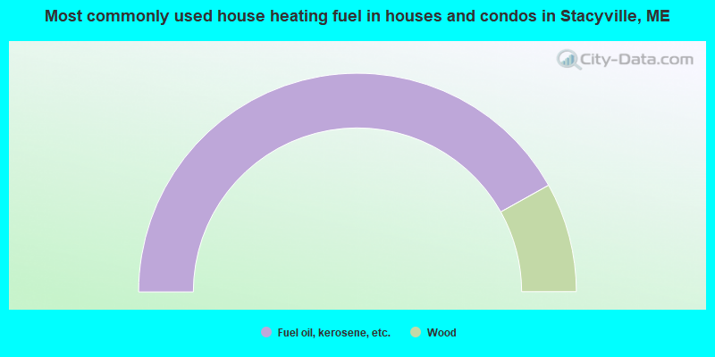
- 83.8%Fuel oil, kerosene, etc.
- 16.2%Wood
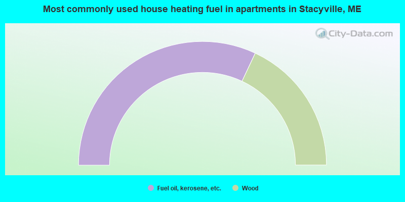
- 64.0%Fuel oil, kerosene, etc.
- 36.0%Wood
Stacyville compared to Maine state average:
- Median house value significantly below state average.
- Black race population percentage significantly below state average.
- Hispanic race population percentage below state average.
- Renting percentage below state average.
- Length of stay since moving in significantly above state average.
- Number of rooms per house significantly below state average.
- House age significantly below state average.
- Number of college students below state average.
- Percentage of population with a bachelor's degree or higher significantly below state average.