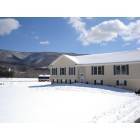
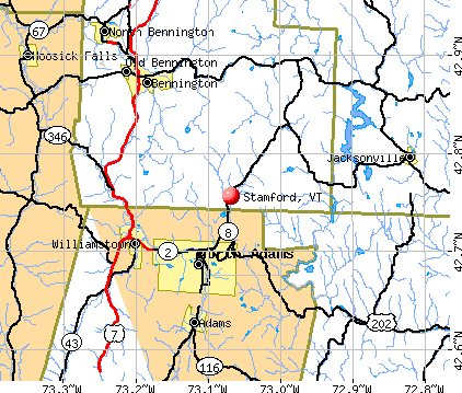
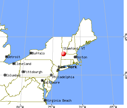
Stamford, Vermont
Submit your own pictures of this town and show them to the world
- OSM Map
- General Map
- Google Map
- MSN Map
Population change since 2000: +1.4%
 |
| Males: 423 | |
| Females: 401 |
| Median resident age: | 47.5 years |
| Vermont median age: | 45.8 years |
Zip codes: 05352.
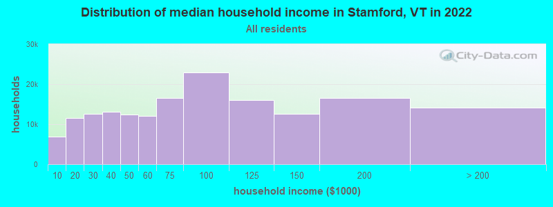
| Stamford: | $84,092 |
| VT: | $73,991 |
Estimated per capita income in 2022: $37,187 (it was $19,575 in 2000)
Stamford town income, earnings, and wages data
Estimated median house or condo value in 2022: $276,372 (it was $115,200 in 2000)
| Stamford: | $276,372 |
| VT: | $304,700 |
Mean prices in 2022: all housing units: $328,619; detached houses: $344,818; townhouses or other attached units: $277,995; in 2-unit structures: $228,670; in 3-to-4-unit structures: $413,467; in 5-or-more-unit structures: $239,659; mobile homes: $88,728
Detailed information about poverty and poor residents in Stamford, VT


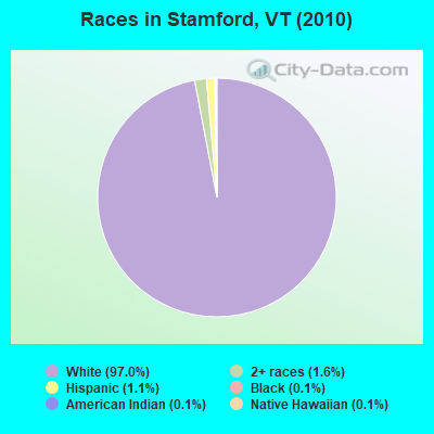
- 79997.0%White alone
- 131.6%Two or more races
- 91.1%Hispanic
- 10.1%Black alone
- 10.1%American Indian alone
- 10.1%Native Hawaiian and Other
Pacific Islander alone
Races in Stamford detailed stats: ancestries, foreign born residents, place of birth
According to our research of Vermont and other state lists, there was 1 registered sex offender living in Stamford, Vermont as of May 18, 2024.
The ratio of all residents to sex offenders in Stamford is 824 to 1.
The ratio of registered sex offenders to all residents in this city is lower than the state average.
 Recent articles from our blog. Our writers, many of them Ph.D. graduates or candidates, create easy-to-read articles on a wide variety of topics.

 | New Amtrak Service Between Rutland and Burlington? (10 replies) |
| Amtrak may discontinue service in Vermont (5 replies) |
| Vermont Rail Ideas (125 replies) |
| Tell me about Bennington, VT (29 replies) |
| Here we go again Vermont.... (16 replies) |
| Cost of living for an individual (10 replies) |
Latest news from Stamford, VT collected exclusively by city-data.com from local newspapers, TV, and radio stations
Ancestries: French (19.4%), Italian (18.3%), Irish (18.0%), English (17.2%), German (11.8%), French Canadian (7.7%).
Current Local Time: EST time zone
Elevation: 1130 feet
Land area: 39.5 square miles.
Population density: 21 people per square mile (very low).
17 residents are foreign born (1.5% Europe, 0.6% Asia).
| This town: | 2.1% |
| Vermont: | 3.8% |
| Stamford town: | 1.5% ($1,705) |
| Vermont: | 2.0% ($2,196) |
Nearest city with pop. 50,000+: Albany, NY  (36.4 miles , pop. 95,658).
Nearest city with pop. 200,000+: Boston, MA (106.1 miles , pop. 589,141).
Nearest city with pop. 1,000,000+: Bronx, NY (139.2 miles , pop. 1,332,650).
Nearest cities:
), ), ), Latitude: 42.77 N, Longitude: 73.08 W
Area code: 802

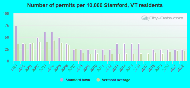
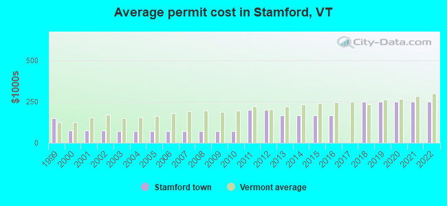
Single-family new house construction building permits:
- 2022: 2 buildings, average cost: $249,800
- 2021: 2 buildings, average cost: $249,800
- 2020: 2 buildings, average cost: $249,800
- 2019: 2 buildings, average cost: $249,800
- 2018: 2 buildings, average cost: $249,800
- 2016: 3 buildings, average cost: $166,500
- 2015: 3 buildings, average cost: $166,500
- 2014: 3 buildings, average cost: $166,500
- 2013: 3 buildings, average cost: $166,500
- 2012: 2 buildings, average cost: $200,000
- 2011: 2 buildings, average cost: $200,000
- 2010: 2 buildings, average cost: $70,000
- 2009: 2 buildings, average cost: $70,000
- 2008: 2 buildings, average cost: $70,000
- 2007: 2 buildings, average cost: $70,000
- 2006: 3 buildings, average cost: $70,000
- 2005: 4 buildings, average cost: $70,000
- 2004: 5 buildings, average cost: $70,000
- 2003: 5 buildings, average cost: $70,000
- 2002: 4 buildings, average cost: $76,700
- 2001: 3 buildings, average cost: $76,700
- 2000: 3 buildings, average cost: $76,700
- 1999: 6 buildings, average cost: $150,000
| Here: | 4.5% |
| Vermont: | 2.0% |
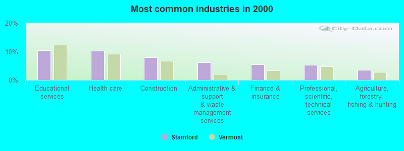
- Educational services (10.5%)
- Health care (10.2%)
- Construction (8.0%)
- Administrative & support & waste management services (6.2%)
- Finance & insurance (5.5%)
- Professional, scientific, technical services (5.2%)
- Agriculture, forestry, fishing & hunting (3.5%)
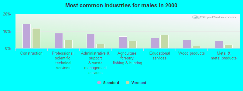
- Construction (14.4%)
- Professional, scientific, technical services (8.9%)
- Administrative & support & waste management services (8.4%)
- Agriculture, forestry, fishing & hunting (6.9%)
- Educational services (5.9%)
- Wood products (5.0%)
- Metal & metal products (4.5%)
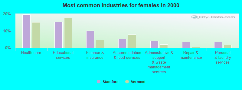
- Health care (19.7%)
- Educational services (15.2%)
- Finance & insurance (10.1%)
- Accommodation & food services (5.1%)
- Administrative & support & waste management services (4.0%)
- Repair & maintenance (3.5%)
- Personal & laundry services (3.5%)
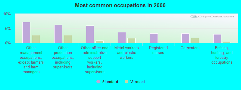
- Other management occupations, except farmers and farm managers (7.2%)
- Other production occupations, including supervisors (6.2%)
- Other office and administrative support workers, including supervisors (6.0%)
- Metal workers and plastic workers (3.8%)
- Registered nurses (3.2%)
- Carpenters (3.2%)
- Fishing, hunting, and forestry occupations (3.0%)
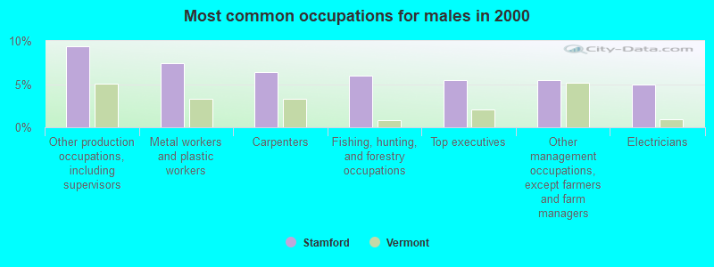
- Other production occupations, including supervisors (9.4%)
- Metal workers and plastic workers (7.4%)
- Carpenters (6.4%)
- Fishing, hunting, and forestry occupations (5.9%)
- Top executives (5.4%)
- Other management occupations, except farmers and farm managers (5.4%)
- Electricians (5.0%)
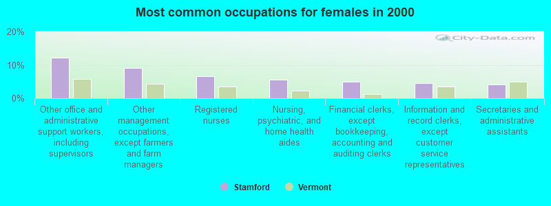
- Other office and administrative support workers, including supervisors (12.1%)
- Other management occupations, except farmers and farm managers (9.1%)
- Registered nurses (6.6%)
- Nursing, psychiatric, and home health aides (5.6%)
- Financial clerks, except bookkeeping, accounting and auditing clerks (5.1%)
- Information and record clerks, except customer service representatives (4.5%)
- Secretaries and administrative assistants (4.0%)
Average climate in Stamford, Vermont
Based on data reported by over 4,000 weather stations


(lower is better)
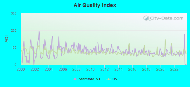
Air Quality Index (AQI) level in 2022 was 63.9. This is about average.
| City: | 63.9 |
| U.S.: | 72.6 |
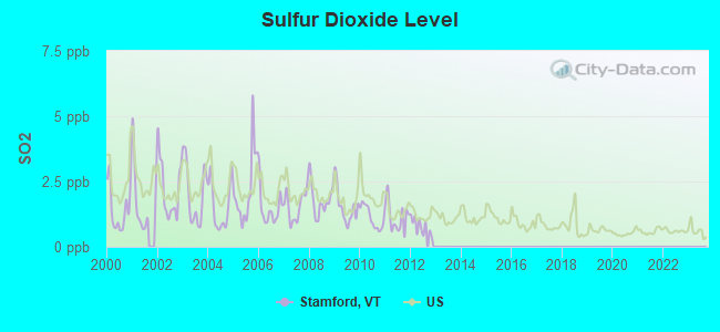
Sulfur Dioxide (SO2) [ppb] level in 2012 was 0.789. This is significantly better than average. Closest monitor was 5.0 miles away from the city center.
| City: | 0.789 |
| U.S.: | 1.515 |
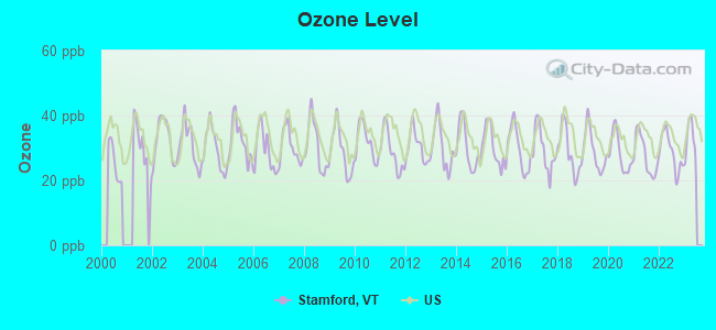
Ozone [ppb] level in 2022 was 28.8. This is about average. Closest monitor was 7.4 miles away from the city center.
| City: | 28.8 |
| U.S.: | 33.3 |
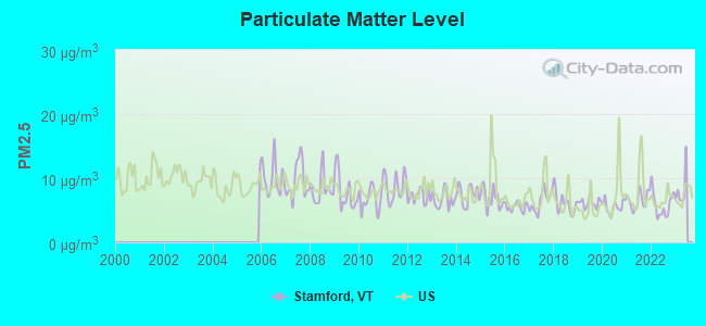
Particulate Matter (PM2.5) [µg/m3] level in 2022 was 5.88. This is better than average. Closest monitor was 4.9 miles away from the city center.
| City: | 5.88 |
| U.S.: | 8.11 |
Tornado activity:
Stamford-area historical tornado activity is significantly above Vermont state average. It is 29% smaller than the overall U.S. average.
On 8/28/1973, a category F4 (max. wind speeds 207-260 mph) tornado 29.8 miles away from the Stamford town center killed 4 people and injured 36 people and caused between $5,000,000 and $50,000,000 in damages.
On 5/31/1998, a category F3 (max. wind speeds 158-206 mph) tornado 12.2 miles away from the town center injured 68 people and caused $71 million in damages.
Earthquake activity:
Stamford-area historical earthquake activity is significantly above Vermont state average. It is 69% smaller than the overall U.S. average.On 10/7/1983 at 10:18:46, a magnitude 5.3 (5.1 MB, 5.3 LG, 5.1 ML, Class: Moderate, Intensity: VI - VII) earthquake occurred 103.6 miles away from the city center
On 4/20/2002 at 10:50:47, a magnitude 5.3 (5.3 ML, Depth: 3.0 mi) earthquake occurred 124.4 miles away from Stamford center
On 4/20/2002 at 10:50:47, a magnitude 5.2 (5.2 MB, 4.2 MS, 5.2 MW, 5.0 MW) earthquake occurred 123.0 miles away from Stamford center
On 1/19/1982 at 00:14:42, a magnitude 4.7 (4.5 MB, 4.7 MD, 4.5 LG, Class: Light, Intensity: IV - V) earthquake occurred 90.2 miles away from the city center
On 10/16/2012 at 23:12:25, a magnitude 4.7 (4.7 ML, Depth: 10.0 mi) earthquake occurred 135.0 miles away from the city center
On 6/17/1991 at 08:53:16, a magnitude 4.1 (4.0 MB, 4.0 LG, Depth: 3.1 mi) earthquake occurred 81.8 miles away from the city center
Magnitude types: regional Lg-wave magnitude (LG), body-wave magnitude (MB), duration magnitude (MD), local magnitude (ML), surface-wave magnitude (MS), moment magnitude (MW)
Natural disasters:
The number of natural disasters in Bennington County (15) is near the US average (15).Major Disasters (Presidential) Declared: 10
Emergencies Declared: 2
Causes of natural disasters: Floods: 8, Storms: 8, Tropical Storms: 2, Winter Storms: 2, Hurricane: 1, Landslide: 1, Snowstorm: 1, Wind: 1, Other: 1 (Note: some incidents may be assigned to more than one category).
Hospitals and medical centers near Stamford:
- NORTH ADAMS COMMONS NURSING AND REHABILITATION CENTE (Nursing Home, about 5 miles away; NORTH ADAMS, MA)
- NORTH ADAMS REGIONAL HOSPITAL Acute Care Hospitals (about 5 miles away; NORTH ADAMS, MA)
- ADAMS N H OF N ADAMS (Nursing Home, about 5 miles away; NORTH ADAMS, MA)
- WILLIAMSTOWN COMMONS NURSING AND REHAB (Nursing Home, about 8 miles away; WILLIAMSTOWN, MA)
- NORTHERN BERKSHIRE COMPREHENSIVE CARE (Home Health Center, about 9 miles away; ADAMS, MA)
- HOSPICE OF N BERKSHIRE INC (Hospital, about 9 miles away; ADAMS, MA)
- CRESCENT MANOR CARE CTRS (Nursing Home, about 10 miles away; BENNINGTON, VT)
Colleges/universities with over 2000 students nearest to Stamford:
- Williams College (about 8 miles; Williamstown, MA; Full-time enrollment: 2,141)
- Rensselaer Polytechnic Institute (about 31 miles; Troy, NY; FT enrollment: 6,940)
- Hudson Valley Community College (about 32 miles; Troy, NY; FT enrollment: 9,346)
- The Sage Colleges (about 32 miles; Troy, NY; FT enrollment: 2,499)
- Siena College (about 35 miles; Loudonville, NY; FT enrollment: 3,153)
- The College of Saint Rose (about 37 miles; Albany, NY; FT enrollment: 4,085)
- SUNY at Albany (about 39 miles; Albany, NY; FT enrollment: 15,490)
Public elementary/middle school in Stamford:
- STAMFORD ELEMENTARY SCHOOL (Students: 77, Location: 986 MAIN ROAD, Grades: KG-8)
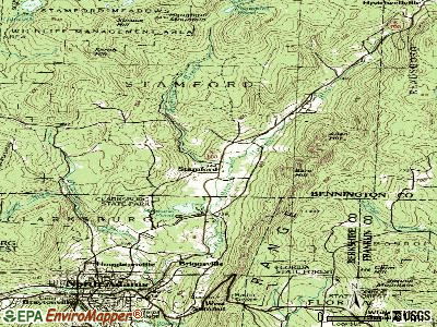
Points of interest:
Notable locations in Stamford: Col Seth Warner Camp (A), Stamford Town Hall (B), Stamford Community Library (C), Stamford Volunteer Fire Department (D). Display/hide their locations on the map
Cemeteries: Miller Cemetery (1), Houghton Cemetery (2). Display/hide their locations on the map
Lakes and swamps: Stamford Pond (A), Lake Hancock (B), Mud Pond (C), Stamford Meadows (D). Display/hide their locations on the map
Streams, rivers, and creeks: Sumner Brook (A), Crazy John Stream (B), Cardinal Brook (C), Brown Brook (D), Roaring Brook (E), Goodrich Brook (F), Fuller Brook (G), Nunge Brook (H), Basin Brook (I). Display/hide their locations on the map
Park in Stamford: Stamford Meadows Wildlife Management Area (1). Display/hide its location on the map
Birthplace of: Frank D. Stafford - Politician.
Drinking water stations with addresses in Stamford and their reported violations in the past:
STAMFORD VALLEY GOLF COURSE (Address: 194 THE LANE , Population served: 130, Groundwater):Past health violations:STAMFORD ELEMENTARY SCHOOL (Address: 986 MAIN RD , Population served: 115, Groundwater):Past monitoring violations:
- MCL, Monthly (TCR) - In JUN-2012, Contaminant: Coliform. Follow-up actions: St Tech Assistance Visit (JUL-26-2012), St Formal NOV issued (JUL-26-2012), St Public Notif requested (JUL-26-2012), St Boil Water Order (JUL-26-2012), St Compliance achieved (AUG-24-2012)
- Monitoring, Repeat Major (TCR) - Between APR-2014 and JUN-2014, Contaminant: Coliform (TCR)
- Monitoring, Source Water (GWR) - In JUL-12-2013, Contaminant: E. COLI. Follow-up actions: St Public Notif requested (AUG-20-2013), St Formal NOV issued (AUG-20-2013), St Compliance achieved (DEC-26-2013)
- Monitoring, Repeat Major (TCR) - Between APR-2013 and JUN-2013, Contaminant: Coliform (TCR). Follow-up actions: St Public Notif requested (AUG-15-2013), St Formal NOV issued (AUG-15-2013), St Compliance achieved (DEC-26-2013)
- Monitoring, Source Water (GWR) - In JUL-11-2012, Contaminant: E. COLI. Follow-up actions: St Formal NOV issued (JUL-25-2012), St Compliance achieved (DEC-26-2013)
- 8 routine major monitoring violations
- One regular monitoring violation
Past monitoring violations:
- 2 routine major monitoring violations
| This town: | 2.5 people |
| Vermont: | 2.3 people |
| This town: | 71.0% |
| Whole state: | 62.5% |
| This town: | 6.3% |
| Whole state: | 9.2% |
Likely homosexual households (counted as self-reported same-sex unmarried-partner households)
- Lesbian couples: 0.3% of all households
- Gay men: 0.6% of all households
| This town: | 3.8% |
| Whole state: | 9.4% |
| This town: | 1.6% |
| Whole state: | 3.6% |
For population 15 years and over in Stamford:
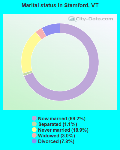
- Never married: 18.9%
- Now married: 69.2%
- Separated: 1.1%
- Widowed: 3.0%
- Divorced: 7.8%
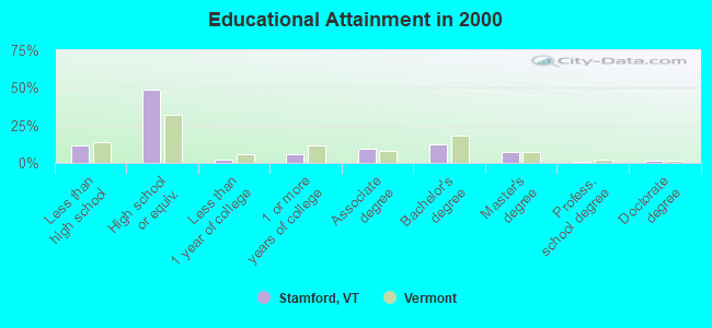
For population 25 years and over in Stamford:
- High school or higher: 88.1%
- Bachelor's degree or higher: 22.0%
- Graduate or professional degree: 9.6%
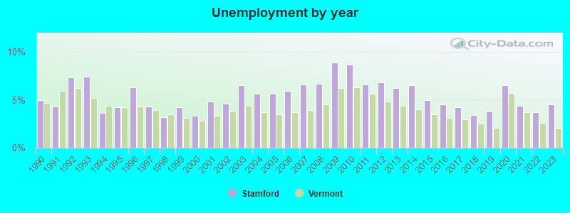
- Unemployed: 5.9%
- Mean travel time to work (commute): 28.8 minutes

| Here: | 11.1 |
| Vermont average: | 11.7 |
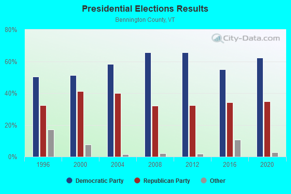
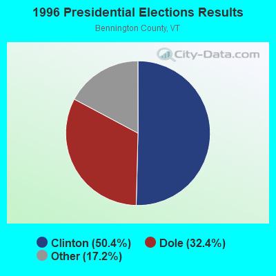
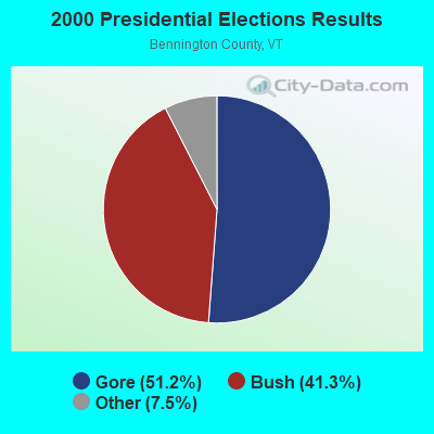
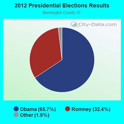
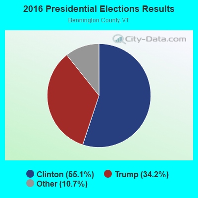
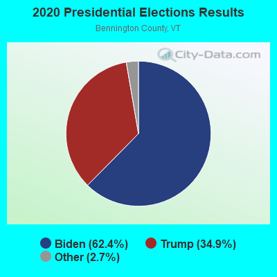
Graphs represent county-level data. Detailed 2008 Election Results
Religion statistics for Stamford, VT (based on Bennington County data)

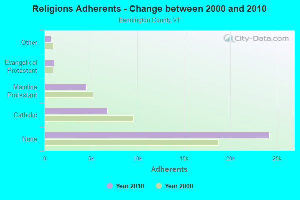
| Religion | Adherents | Congregations |
|---|---|---|
| Catholic | 6,742 | 8 |
| Mainline Protestant | 4,490 | 26 |
| Evangelical Protestant | 1,005 | 12 |
| Other | 693 | 5 |
| None | 24,195 | - |
Food Environment Statistics:
| Bennington County: | 3.85 / 10,000 pop. |
| State: | 3.84 / 10,000 pop. |
| Bennington County: | 3.30 / 10,000 pop. |
| State: | 1.95 / 10,000 pop. |
| This county: | 5.77 / 10,000 pop. |
| Vermont: | 6.40 / 10,000 pop. |
| Bennington County: | 16.48 / 10,000 pop. |
| State: | 11.52 / 10,000 pop. |
| Bennington County: | 8.4% |
| Vermont: | 6.8% |
| Bennington County: | 22.9% |
| State: | 22.3% |
| Bennington County: | 11.6% |
| State: | 13.3% |
Strongest AM radio stations in Stamford:
- WNNZ (640 AM; 50 kW; WESTFIELD, MA; Owner: CLEAR CHANNEL BROADCASTING LICENSES, INC.)
- WGY (810 AM; 50 kW; SCHENECTADY, NY; Owner: CLEAR CHANNEL BROADCASTING LICENSES, INC.)
- WNAW (1230 AM; 1 kW; NORTH ADAMS, MA; Owner: BERKSHIRE BROADCASTING CO., INC.)
- WPTR (1540 AM; 50 kW; ALBANY, NY; Owner: KIMTRON, INC.)
- WCRN (830 AM; 50 kW; WORCESTER, MA; Owner: CARTER BROADCASTING CORPORATION)
- WIZZ (1520 AM; daytime; 10 kW; GREENFIELD, MA; Owner: P. & M. RADIO, LLC)
- WTIC (1080 AM; 50 kW; HARTFORD, CT; Owner: INFINITY RADIO OPERATIONS INC.)
- WVNE (760 AM; daytime; 25 kW; LEICESTER, MA; Owner: BLOUNT MASSCOM, INC.)
- WRKO (680 AM; 50 kW; BOSTON, MA; Owner: ENTERCOM BOSTON LICENSE, LLC)
- WUHN (1110 AM; daytime; 5 kW; PITTSFIELD, MA; Owner: WEINER BROADCASTING, INC.)
- WEEI (850 AM; 50 kW; BOSTON, MA; Owner: ENTERCOM BOSTON LICENSE, LLC)
- WBTN (1370 AM; 1 kW; BENNINGTON, VT; Owner: SOUTHERN VERMONT COLLEGE)
- WALE (990 AM; 50 kW; GREENVILLE, RI; Owner: NORTH AMERICAN BROADCASTING CO., INC.)
Strongest FM radio stations in Stamford:
- WAMC-FM (90.3 FM; ALBANY, NY; Owner: WAMC)
- WMNB (100.1 FM; NORTH ADAMS, MA; Owner: BERKSHIRE BROADCASTING CO., INC.)
- WVAY (100.7 FM; WILMINGTON, VT; Owner: GREAT NORTHERN RADIO, L.L.C.)
- WEQX (102.7 FM; MANCHESTER, VT; Owner: NORTHSHIRE COMMUNICATIONS, INC.)
- WJAN (95.1 FM; SUNDERLAND, VT; Owner: 6 JOHNSON ROAD LICENSES, INC.)
- WZEC (97.5 FM; HOOSICK FALLS, NY; Owner: GREAT NORTHERN RADIO, LLC)
- WRSY (101.5 FM; MARLBORO, VT; Owner: GREAT NORTHERN RADIO, L.L.C.)
- WJJR (98.1 FM; RUTLAND, VT; Owner: 6 JOHNSON ROAD LICENSES, INC.)
- WZRT (97.1 FM; RUTLAND, VT; Owner: CAPSTAR TX LIMITED PARTNERSHIP)
- WPVQ (95.3 FM; GREENFIELD, MA; Owner: GREAT NORTHERN RADIO, L.L.C.)
- WEBK (105.3 FM; KILLINGTON, VT; Owner: 6 JOHNSON ROAD LICENSES, INC.)
- WVPR (89.5 FM; WINDSOR, VT; Owner: VERMONT PUBLIC RADIO)
- WHDQ (106.1 FM; CLAREMONT, NH; Owner: GREAT NORTHERN RADIO, L.L.C.)
- WNGN (91.9 FM; ARGYLE, NY; Owner: NORTHEAST GOSPEL BROADCASTING INC)
- WKVT-FM (92.7 FM; BRATTLEBORO, VT; Owner: SAGA COMMUNICATIONS OF NEW ENGLAND, LLC)
- WGLV (91.7 FM; WOODSTOCK, VT; Owner: CHRISTIAN MINISTRIES INC)
- WHDQ-FM1 (106.1 FM; RUTLAND, VT; Owner: GREAT NORTHERN RADIO, L.L.C.)
- WCMK (91.9 FM; PUTNEY, VT; Owner: CHRISTIAN MINISTRIES INC)
- WHVP (91.1 FM; HUDSON, NY; Owner: SOUND OF LIFE, INC.)
- WBEC-FM (105.5 FM; PITTSFIELD, MA; Owner: GREAT NORTHERN RADIO, LLC)
TV broadcast stations around Stamford:
- WCDC-TV (Channel 19; ADAMS, MA; Owner: YOUNG BROADCASTING OF ALBANY, INC.)
- W38DL (Channel 38; ADAMS, ETC., MA; Owner: WNYT-TV, LLC)
- WNGN-LP (Channel 26; TROY, NY; Owner: BRIAN A. LARSON)
- W35BK (Channel 35; PLAINFIELD, MA; Owner: LYDIA SYLVANE STOCKWELL)
Stamford fatal accident list:
Sep 4, 1988 01:30 AM, 12, Vehicles: 1, Persons: 1, Fatalities: 1, Drunk persons involved: 1
Oct 29, 1982 04:50 PM, Vt8, Vehicles: 1, Persons: 1, Fatalities: 1, Drunk persons involved: 1
Apr 28, 1979 09:25 PM, Vehicles: 1, Persons: 2, Fatalities: 2, Drunk persons involved: 1
- National Bridge Inventory (NBI) Statistics
- 13Number of bridges
- 59ft / 18.5mTotal length
- $584,000Total costs
- 6,422Total average daily traffic
- 384Total average daily truck traffic
- 6,746Total future (year 2026) average daily traffic
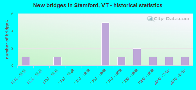
- New bridges - historical statistics
- 11910-1919
- 11930-1939
- 51960-1969
- 11970-1979
- 21980-1989
- 11990-1999
- 12000-2009
- 12010-2019
FCC Registered Amateur Radio Licenses:
5- Call Sign: K1DEU, Licensee ID: L00268314, Grant Date: 01/05/2005, Expiration Date: 09/22/2014, Cancellation Date: 09/23/2016, Registrant: John D Shaw, 5338 Main Rd, Stamford, VT 05352
- Call Sign: N1KNL, Licensee ID: L00455462, Grant Date: 09/22/2011, Expiration Date: 11/12/2021, Cancellation Date: 11/14/2023, Registrant: Bruce C Robare, 315 Main Rd, Stamford, VT 05352-9726
- Call Sign: W1CLW, Previous Call Sign: AA1XH, Licensee ID: L00297024, Grant Date: 10/15/2020, Expiration Date: 12/19/2030, Certifier: Charles L Welsch, Registrant: Charles L Welsch, 1682 East Road, Stamford, VT 05352
- Call Sign: KB1WCW, Licensee ID: L01664203, Grant Date: 09/10/2021, Expiration Date: 09/29/2031, Certifier: Bruce F Bensen, Registrant: Bruce F Bensen, 146 Brookside Dr, Stamford, VT 05352
- Call Sign: KC1MLX, Licensee ID: L02317548, Grant Date: 01/14/2020, Expiration Date: 01/14/2030, Certifier: Stewart D Johnson, Registrant: Stewart D Johnson, 370 Boulger Rd, Stamford, VT 05352
FAA Registered Aircraft:
2- Aircraft: HELDEBERG DESIGNS LLC BLUE HERON MARATHON (Category: Land, Seats: 2, Weight: Up to 12,499 Pounds), Engine: ROTAX 582SER (65 HP) (2 Cycle)
N-Number: 55FZ, N55FZ, N-55FZ, Serial Number: HD00044M, Year manufactured: 2000, Airworthiness Date: 07/03/2007, Certificate Issue Date: 02/16/2007
Registrant (Individual): Michael J Kuranda, 323 The Lane, Stamford, VT 05352 - Aircraft: CESSNA 172N (Category: Land, Seats: 4, Weight: Up to 12,499 Pounds, Speed: 105 mph), Engine: LYCOMING 0-320 SERIES (180 HP) (Reciprocating)
N-Number: 738CG, N738CG, N-738CG, Serial Number: 17269867, Year manufactured: 1977, Airworthiness Date: 11/30/1977, Certificate Issue Date: 10/22/1991
Registrant (Individual): Peter C French, 4581 Main Rd, Stamford, VT 05352
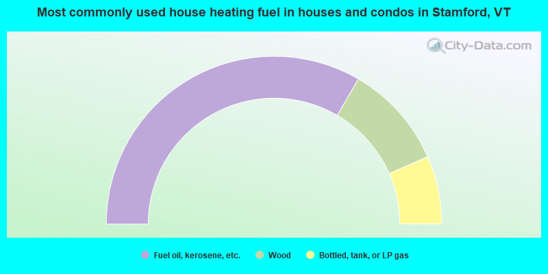
- 66.8%Fuel oil, kerosene, etc.
- 20.1%Wood
- 13.1%Bottled, tank, or LP gas
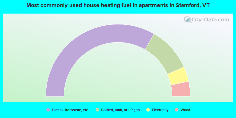
- 66.7%Fuel oil, kerosene, etc.
- 20.0%Bottled, tank, or LP gas
- 6.7%Electricity
- 6.7%Wood
Stamford compared to Vermont state average:
- Unemployed percentage below state average.
- Black race population percentage significantly below state average.
- Hispanic race population percentage below state average.
- Foreign-born population percentage below state average.
- Renting percentage significantly below state average.
- Length of stay since moving in significantly above state average.
- Number of rooms per house significantly below state average.
- House age significantly below state average.
- Number of college students below state average.

|
Total of 1 patent application in 2008-2024.